122 316 résultats
1393o.J.
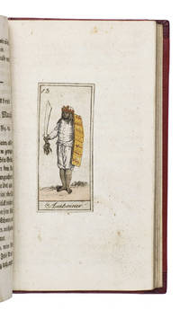
181118884Köln 1811. 12mo. Later gold-tooled half red morocco red paper over boards with the title in gold on the spine. With 24 numbered engravings 7 x 3 cm showing the peoples discussed in their traditional costumes each mounted on a blank leaf. With the engravings coloured as published as indicated on the title page. 170 4 pp. Extremely rare copy of the second edition of an already very rare work presenting the geography and anthropology of the foreign world in the form of a story told in 24 winter evenings by a father to his children. It is divided into 24 chapters each describing the inhabitants of a specific region in Africa the Americas Australia Asia and Europe each with a hand-coloured illustration. The equally rare first edition published by Bieling in Nürnberg in 1810 contains the plates from Johann Sigmund Stoy Bilder-Akademie für die Jugend 1784 while the illustrations in present anonymous edition are printed from new plates implying a possible pirated edition.It treats the Khoikhoi the inhabitants of Guinea the Caribbean Florida and Mexico the Eskimos the inhabitants of Greenland and Patagonia the "Pescherans" from Tierra del Fuego the inhabitants of New Zealand the Australian aboriginies called "New Hollanders" the inhabitants of Java and Amboina & Makassar the Moguls in India the inhabitants of Bukhara and China the Kalmyks Mongols and Buryatians the inhabitants of Tunguska and Kamchatka the Ostyaks the Samoyedic peoples and the Laplanders. Although published as a complete work by itself it was so successful that Bieling published a companion volume covering different regions in 1811: Schilderung der Vornehmsten Völker.The title-page mentions the work is written by the author of Unterhaltende Erzählungen für das erste Kindesalter 1809 apparently the same anonymous author who also wrote Julius merkwürdige Abentheuer 1813-1817 and Das goldene Buch für Kinder 1811 all published by Bieling in Nürnberg.The boards show very minor signs of wear the title-page shows traces of earlier endleaves some very minor occasional spotting. Otherwise in very good condition. An extremely rare copy of an early 19th-century German children's book teaching geography and anthropology.l WorldCat 1082152367 1 copy Universität Frankfurt; cf. GVK 2 copies of the first edition; Wegehaupt 1154 first edition lacking title-page; not in Lipperheide; Sabin etc. ABE CAT Anthropology & Ethnography ABE CAT Costumes & Uniforms hardcover
191748289China, 1910-1917. Oblong folio (306 x 252 mm). Contemporary half leather album of 230 photographs (average size 9 x 12 cm).
190651692[Indien], um 1906. 227 Original-Photographien (meist ca. 18 x 24 cm bzw. 23 x 28 cm), aufgezogen auf 181 Kartonblätter (37 x 29,5 cm). In 2 Schubern. - II: "Indien" (Einbandtitel). Album mit 33 Original-Photographien (meist 24 x 30 cm), auf Kartonblätter montiert. Um 1900-1910. Leinenband der Zeit.
180148366London, printed by T. Rickaby for J. Debrett and the author, 1801. Folio (285 x 447 mm). (2), II, 144, (6) pp. With 20 hand-coloured aquatint plates, each showing several coastal views, and 24 hand-coloured detailed plans on 12 plates, engraved by John Luffman. Contemporary half calf over marbled boards with giltstamped red spine label. Later endpapers.
180845594Paris, l'Imprimerie Impériale (J.J. Marcel) for Treuttel and Würtz, 1808. 3 text volumes (8vo) & atlas volume (folio). The atlas with 92 engraved illustrations on 61 leaves by De Guines after Deserve and 6 engraved maps (4 folding) by d'Houdan. Contemporary gold-tooled tree calf with marbled endpapers (text vols.), modern gold-tooled half sheepskin, marbled sides (atlas). The atlas untrimmed, leaving deckles intact.
166747866Amsterdam, Janssonius, Waesberge & Weystraet, 1667. Folio. (14), 237, (10) pp. With frontispiece, vignette on title, portrait of the author, 2 engraved maps (folded), 23 plates (one folded), and 59 engraved illustrations in the text. Contemporary calf.
In Venetia, per Gioan. Baptista Pedrezano, 1548, in-8, legatura seicentesca in piena pergamena floscia, cc. [8], 214, [64], la c. DD8 bianca. Con bordi laterali del frontespizio decorati in xilografia, bella figura di Tolomeo che osserva il cielo impresso in xilografia al recto della seconda carta, illustrazioni xilografiche n.t. e 60 carte geografiche incise in rame su tavole doppie f.t. (incluse due carte mondiali). Le tavole recano il testo esplicativo sul verso. Due marche in xilografia dell'editore Pedrezano: una alla fine del testo e una alla fine dell'indice, sull'ultima carta del volume. Al colophon, posto alla fine del testo (carta c. DD7r): "In Venetia, ad instantia di messer Giovanbattista Pedrezano libraro al segno della torre a pie del ponte di Rialto stampato per Nicolo Bascarini, 1547, del mese di ottobre". Prima edizione con le carte geografiche incise da Giacomo Gastaldi; prima edizione della traduzione italiana di Pietro Andrea Mattioli. "This important edition, printed in a portable format and thus the first to address the needs of travellers, contains the first full series of Ptolemaic maps to appear since the incunable editions of the preceding century. The maps of the present edition were engraved by the prolific Giacomo Gastaldi (c.1500-c.1565), cosmographer to the Republic of Venice; while Gastaldi based his engravings of the 26 Ptolemaic maps on the woodcuts by Münster which illustrated the 1540 Basel edition, the 34 modern maps (which are interposed between the ancient maps), were of his own design, and contain significant innovations. The Americas appear, linked by a land extension to Asia, in the modern World map (map 59) and in the 'Carta marina' (map 60; the first sea chart depicting the modern world) and five maps are devoted exclusively to the Americas. These five maps are the earliest printed American regional maps: they include the first separate map of the South American Continent ('Tierra nova', map 54); the earliest separate map of the Gulf Coast, Mexico, and the present south-western United States ('Nueva Hispania', map 55); the earliest individual map of the east coast of North America ('Tierra nueva [del Bacalaos]', map 56), showing the discoveries of Verrazzano and Cartier. The translation by the botanist Pietro Andrea Mattioli appears in this edition only; it was superseded by Girolamo Ruscelli's translation, which was first published in 1561 and frequently reprinted. The only earlier Italian version was Berlinghieri's verse paraphrase (Florence: ca. 1482)". L'esemplare si presenta in buone condizioni, tranne che per la carta geografica n. 54 (Tierranova) che presenta degli strappi restaurati nel campo inciso, all'angolo superiore sinistro, con lievi perdite e, nell'angolo inferiore destro, un piccolo tassello di carta che reintegra, in maniera manoscritta, una piccola porzione mancante di campo inciso. La tavola n. 55 reca due strappetti ben restaurati, senza alcuna perdita.
192645588Paris & Brussels, G. Vanoest, 1926. 3 volumes. VI, 73, [3 blank]; [3], [1 blank]; [3], [1 blank] pp. With 12 plans and 2 maps (mostly folding), and a total of 274 plates with heliotypes. Publisher's original printed blue paper wrappers.
1909000140<p><strong>80 × 75 cm. Produced by KolaÄŸası Osman Nuri secretary of the Military School of Geography in 1323 AH 1907 AD.</strong></p><p>The map rarely includes a small inset map of the city of DirÊ¿iyyah in the Najd region together with additional inset maps of Medina ṬÄʾif Mecca and the harbor of Jeddah.</p> The Ottoman geographical military school, war press
161048877Altenburg in Meißen, for Henning Grosse (in Leipzig), 1610. 8vo. (16), 180, (6) pp. Title printed in red and black. With 6 folding engraved plates. - (Bound after) II: Megiser, Hieronymus. Paradisus deliciarum; das ist, eigentliche und wahrhafftige Beschreibung der wunderbaren, mechtigen und in aller Welt hochberümbten Stadt Venedig [...]. Leipzig, (Michael Lantzenberger for) Henning Grosse, 1610. (24), 495, (13) pp. Title printed in red and black. With engraved Dietrichstein arms on the verso of title and 25 (instead of 26) engraved plates (mostly folded, one double-page-sized). - (Includes:) Chronologia Veneta. (94) pp., 1 blank f., (62) pp., final blank f. Contemporary blindstamped leather with handwritten labels to spine; remains of clasps. Edges goffered and coloured blue.
In folio (mm. 425 x 288), p. pergamena moderna con legacci, 4 cc.nn. (compreso il bel frontespizio inc. in rame da Oliviero Gatti, e l’Indice), 24 pp.num. (di descrizione generale dell’Italia), con 61 carte geografiche dedicate agli stati italiani, pure inc. in rame e a doppia pag. [salvo 2 a una pag. (Territorio Cremasco - Il Cadorino) e 1 in ‘quarto’ (Elba isola)]. L'opera è dedicata da Fabio Magini a Ferdinando Gonzaga, Duca di Mantova e di Monferrato. Al “verso” della 4a c.nn. si ha la scritta: In Bologna, MDCXXX, presso Clemente Ferroni. La prima edizione si pubblicò nel 1620 a Bologna, per Sebastiano Bonomi; le edizioni successive recarono al frontespizio la data dell'edizione originale portando invece al verso della 4a carta la data reale. "Seconda edizione" di questo celebrato Atlante. Cfr. Almagià “L’Italia di G.A. Magini” (1922), p. V: “La più vasta e importante opera cartografica sull’Italia.. messa insieme dall’astronomo padovano Giovanni Antonio Magini (1555-1617)” e a p. 7: “Ristampa che porta il nome dello stampatore bolognese Clemente Ferroni.. Il Ferroni dovette poi, negli anni successivi, continuare a dar fuori l’opera, perchè se ne hanno molteplici esemplari ma senza più la data 1630 e accresciuti invece di un ritratto del Magini.. Il testo della descrizione dell’Italia è ovunque il medesimo, e quel che più importa, le carte sono sempre identiche e riprodotte sempre dagli stessi rami”. Cat. Piantanida,1350: "Atlante rinomato e pregiato al quale l'A. dedicò gran parte delle sue fatiche nell'ultimo ventennio della sua vita.. egli preparò carte in gran parte originali, delineate cioè in base a rilievi ufficiali fatti eseguire dai vari governi italiani e che egli riuscì a procurarsi per il benevolo interessamento dei Gonzaga. Il lavoro di raccolta, di coordinazione, di revisione e di disegno e incisione non fu molto semplice: l'A. dovette mantenere presso di sè abili incisori specializzati; alcune carte furono stampate e messe in circolazione isolatamente per saggio; nel 1608 fu pubblicata col titolo di "Italia Nuova" una carta generale, insigne lavoro di sintesi; ma la definitiva elaborazione dell'intero atlante tardò ancora e la stampa era appena avviata quando l'A. mori'. Esso pertanto fu pubblicato postumo dal figlio Fabio. Questo atlante esercitò un'immensa influenza: le sue tavole furono ricopiate, contraffatte, imitate moltissime volte in Italia e all'estero; entrarono, senza modificazioni, a far parte di atlanti stranieri notissimi, come quelli del Bleau; in Italia rimasero monumento insuperato per oltre un secolo”. Le seguenti 5 carte presentano: Ducato di Mantova (aloni e fiorit.) - Ducato di Ferrara (qualche alone solo margin.) - Dominio Fiorentino e Stato della Chiesa (restauri per picc. strappi margin.) - Regno di Napoli (con alone) e, sul margine di alc. carte, sbavature di inchiostro tipografico. A parte questi difetti, il ns. esemplare è ben conservato.
2 tomi in un vol. in-folio, ff. (2), 62, 21, 14; 212, (30), bella leg. coeva p.perg. rigida, dorso a nervi con titolo e fregio a mano. Impresa tipogr. sui due titoli, varie iniziali istoriate ed ornate, figure geografiche silogr., 64 belle ed esatte carte geografiche inc. in rame da G.Porro su mezza pag. (il planisfero su pag.intera). Prima edizione italiana del Tolomeo curato da G.A.Magini, famoso cosmografo e matematico padovano. Esemplare completo del mappamondo a piena pag. che sovente manca. Comprende 33 carte dell'Europa, 20 dell'Asia, 6 dell'Africa, una dell'America e 4 mappamondi. L'opera costituisce il fondamentale compendio delle conoscenze geografiche generali e storico-topografiche sino alla fine del XVI secolo. E' corredato di copiosi indici sistematici che ne facilitano la consultazione. Questa versione del Magini dell'opera tolemaica è tra le più attraenti per il suo formato in-folio. Bell'esemplare, fresco, in legatura del tempo.. Sabin 66506. Phillips 405.Shirley, Early Printed Maps of the Brit. Isles 377 f. Alden 598/83..
Leiden, Iodocus à Colster, 1617. 4to. Completely uncut, in the original interim boards, rebacked in matching paper and with leather cords. A bit of soiling to especially front board. Internally a nice, clean, fresh, and unrestored copy. (12), 263, (1) pp. Illustrated.
179653643No place, ca. 1796. Large 4to (214 x 257 mm). Album of 18 original watercolours, all pasted to tabs. Later straight-grained red morocco with prettily gilt spine and spine and upper cover labels.
187048006No place, circa 1870. 2 panoramas, each composed of four consecutive albumen prints. 1100 x 210 mm.
180149522London, A. Arrowsmith No. 24 Rathbone Place, 1801. Engraved map, fine original hand-colour, edged with blue silk, housed in original marbled paper chemise and slipcase, with red morocco label, lettered in gilt. 1470 x 1290 mm.
184357442Würzburg, Eckert & Christian Weiss, (1838-1843). Folio (250 x 359 mm). 2 vols. Together 382 (instead of 384) coloured lithographed plates, some heightened with egg-white. The majority mounted on thick paper with the blind stamp of Eckert & Weiß. Captioned in German. Contemporary half calf with giltstamped spine and spine-title. Marbled endpapers.
173159772Lisbon, Officina Ferreiriana, 1731. Folio (208 x 280 mm). (16), 100 pp. Title printed in red and black. With woodcut title vignette and full-page woodcut of the author at the end of the preliminaries. Contemporary mottled calf ruled in blind, spine tooled in gilt, red morocco spine label titled in gilt.
181846929Frankfurt am Main, Gebr. Wilmans (gedruckt bei Carl Ludwig Brede in Offenbach), 1818. 2 Bde. (12), 376 SS. (8), 283, (1) SS. Mit 2 gest. Titeln, 25 Kupfertafeln (zumeist nach Radl) und 1 gef. Tabelle (Bevölkerungstafel). Ohne dem gefalteten Plan von Frankfurt. Rote genarbte Ziegenlederbände der Zeit mit goldgepr. Rückenschildchen sowie reicher Rücken-, Deckel-, Steh- und Innenkantenvergoldung. Seidenvorsätze; dreiseitiger Goldschnitt. Kl.-Folio (224 x 284 mm).
168748792Augsburg, Jakob Koppmayer, 1685-1687. Folio (230 x 350 mm). Parts 1 and 2 (of 4) in one volume, each with separate title-page printed in red and black. (8), 163, (9), 12 pp. With engraved frontispiece, engr. portrait, 2 folding engr. maps, 46 double-page-sized or folding engr. views of cities and fortresses, naval battles, historical scenes, equestrian portraits, plants, etc. (the Tower of Babylon on two unconjoined plates), 3 engravings in the text, and 12 woodcuts in the text (4 of which are full-page). (4), 140, (4) pp. With engr. frontispiece, 2 double-page-sized engraved maps, and 36 mostly double-page-sized or folded views and plates (including two plates showing two smaller views each). 18th century red half calf over marbled boards.
60409 ½ inches 24 cm. diameter; 21 inches 53 cm. total height. Single pedestal globe with horizon ring armature & meridian all of wood wear and staining on meridian at point where fits into stand some chipping at extremities else fine; globe with vibrant original color and clear sharp patina; some abrasion & losses mostly in lower and upper extremities; overall very good plus condition.<br /><br />An attractive very capably executed table or desk globe in the distinctive style of the Delamarche firm <i>"the most successful French entrepreneurs in maps and globes"</i> Dekker/ van der Krogt. This was an original work by the son Felix who succeeded his father in the management of the firm in 1817. The globe is geographically up-to-date notably in the South Pacific and Alaska with information from then recent Russian voyages such as Krusenstern's. Related to this at the time the globe appeared and reflected on it Europeans were beginning to differentiate between various regions of the Pacific. These were based on a better understanding of cultural and other differences between the peoples of various areas encountered on these recent voyages. For example in 1831 the French explorer Dumont d'Urville proposed the use of the terms "Micronesia" and "Melanesia" for various parts of the Pacific as distinguished from Polynesia. Printed dashed lines on this globe labeled "Division Oceanique" roughly approximate the three eventually accepted divisions of what is referred to as the South Pacific though the regions are not named on the globe. Delamarche also clearly identifies on the globe the more traditional divisions of the Pacific between "Grand Ocean Boreal" "Grand Ocean Equinoxial" and "Grand Ocean Austral."<br /><br />The Delamarche firm was the first to successfully reach a fairly sizable general market of globe buyers. It accomplished this by reducing the cost of constructing globe stands and other parts while maintaining a high level of quality in the maps of their globes which are cleanly and attractively engraved. Traditional brass meridians were replaced by wooden ones and the horizon rings and armatures supporting the rings were greatly simplified and made from either wood or stiff board. Also the firm generally used simpler single-pedestal stands rather than four-legged designs. Yet as this well-preserved example demonstrates Delamarche's design and materials proved to be very durable.<br /><br />Charles-Francois Delamarche 1740-1817 the founder of the family firm was the successor of the great map and globe-making family the Robert De Vaugondys as is cited in the title of this globe. Delamarche in fact seemed to have cornered the globe market in France by also incorporating the stocks of Jean Fortin and Jean Lattre. Delamarche's son Felix took over the firm upon his father's death and managed it until 1848 when Gosselin succeeded him. The firm continued well into the latter 19th century under yet another Delamarche descendent.<br /><br />Dekker/ Van der Krogt <i>Globes from the Western World</i> pp. 63 74; Dekker E. <i>Globes at Greenwich</i> pp. 321-25; Suarez T. <i>Early Mapping of the Pacific</i> p. 25.
60409 ½ inches 24 cm. diameter; 21 inches 53 cm. total height. Single pedestal globe with horizon ring armature & meridian all of wood wear and staining on meridian at point where fits into stand some chipping at extremities else fine; globe with vibrant original color and clear sharp patina; some abrasion & losses mostly in lower and upper extremities; overall very good plus condition.<br /><br />An attractive very capably executed table or desk globe in the distinctive style of the Delamarche firm <i>"the most successful French entrepreneurs in maps and globes"</i> Dekker/ van der Krogt. This was an original work by the son Felix who succeeded his father in the management of the firm in 1817. The globe is geographically up-to-date notably in the South Pacific and Alaska with information from then recent Russian voyages such as Krusenstern's. Related to this at the time the globe appeared and reflected on it Europeans were beginning to differentiate between various regions of the Pacific. These were based on a better understanding of cultural and other differences between the peoples of various areas encountered on these recent voyages. For example in 1831 the French explorer Dumont d'Urville proposed the use of the terms "Micronesia" and "Melanesia" for various parts of the Pacific as distinguished from Polynesia. Printed dashed lines on this globe labeled "Division Oceanique" roughly approximate the three eventually accepted divisions of what is referred to as the South Pacific though the regions are not named on the globe. Delamarche also clearly identifies on the globe the more traditional divisions of the Pacific between "Grand Ocean Boreal" "Grand Ocean Equinoxial" and "Grand Ocean Austral."<br /><br />The Delamarche firm was the first to successfully reach a fairly sizable general market of globe buyers. It accomplished this by reducing the cost of constructing globe stands and other parts while maintaining a high level of quality in the maps of their globes which are cleanly and attractively engraved. Traditional brass meridians were replaced by wooden ones and the horizon rings and armatures supporting the rings were greatly simplified and made from either wood or stiff board. Also the firm generally used simpler single-pedestal stands rather than four-legged designs. Yet as this well-preserved example demonstrates Delamarche's design and materials proved to be very durable.<br /><br />Charles-Francois Delamarche 1740-1817 the founder of the family firm was the successor of the great map and globe-making family the Robert De Vaugondys as is cited in the title of this globe. Delamarche in fact seemed to have cornered the globe market in France by also incorporating the stocks of Jean Fortin and Jean Lattre. Delamarche's son Felix took over the firm upon his father's death and managed it until 1848 when Gosselin succeeded him. The firm continued well into the latter 19th century under yet another Delamarche descendent.<br /><br />Dekker/ Van der Krogt <i>Globes from the Western World</i> pp. 63 74; Dekker E. <i>Globes at Greenwich</i> pp. 321-25; Suarez T. <i>Early Mapping of the Pacific</i> p. 25. books
182211087Paris, de l’imprimerie de Jules Didot l’aîné, imprimeur du Roi, 1822-1826. 2 volumes in-plano, [8] pages pour le faux-titre, le titre, la dédicace et l'avis de l’éditeur; 40 pages pour le précis historique de la Sicile, [90] pages de notices; 1 carte et 45 planches; [4] pages pour le faux-titre, le titre; [94] pages de notices, 2 pages de table; 48 planches. Demi-chagrin rouge à coins. Quelques défauts aux reliures (coins frottés, épidermures), rousseurs parfois prononcées. Le doreur a inscrit au dos "Voyage en Cicile"!
187464884Berlin, R. Wagner, (1871-1874). Imp.-Fol. (62 x 53 cm). Mit 34 chromolithogr. Farbtafeln v. R. Steinbock (27) u. W. Loeillot (7) nach Eduard Hildebrandt, vom Verlag auf Untersatzkartons montiert. Zus. m. dem letzten Orig.-Lieferungsumschlag lose in schwarz- u. goldgepr. illustr. OLwd.-Mappe.