[ATLAS COMPOSITE/COMPOSITE ATLAS] FER (Nicolas de).Livre Rare Book
199 résultats
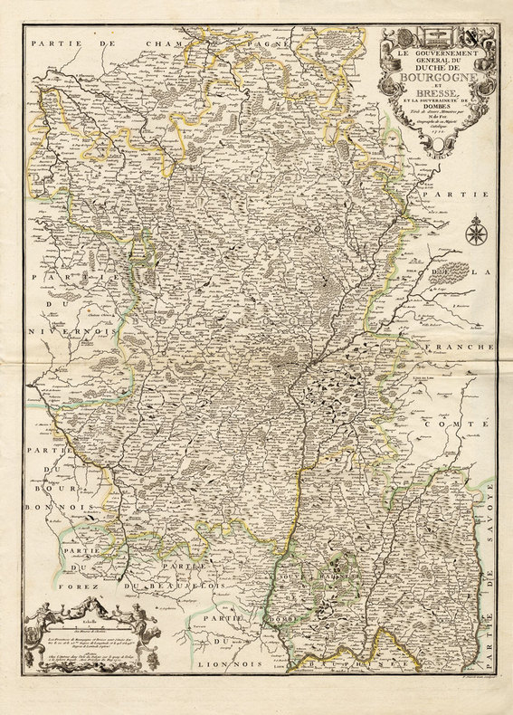
17284155Paris, de Beaurain Geographe du Roy, 1728. 1728 1 vol. in-4° (273 x 250 mm) de : 1 titre manuscrit avec lettres caligraphiées en rouge, bleu et or dans un encadrement de frises ; [188] ff. (dont 50 ff. de texte sur double page, 5 ff. de texte sur page simple, 133 cartes et planches sur double page dont 13 dépliantes). (Corps d'ouvrage très frais). Plein maroquin brun d'époque, dos à nerfs orné, triple encadrement de filets dorés sur les plats avec fleurons angulaires, roulette dorée sur les coupes, dentelles intérieures tranches dorées.
171216203Paris, chez l'Auteur, 1712 ; grande carte (cuvette du cuivre : 67,5 x 49 cm), coloris d'époque.
17671186551767 in-folio [A Paris, chez SAILLANT & NYON, DESAINT,] imprimerie L. F. DELATOUR, 1767, 1 volume in-folio de 285x430 mm environ, (1) f., page de titre, IIJ, 302 pages, complet des 43 planches in-fine (dont une bis). Demi-basane havane postérieure, dos long portant titres et ex libris dorés, tranches mouchetées, gardes blanches. Reliure usée (coiffe de queue manquante, cuir épidermé par endroits, étiquette papier sur le dos, manque de papier sur le plat inférieur) mais exemplaire solide, rares traces de manipulation en marge de certains feuillets, bon état général.
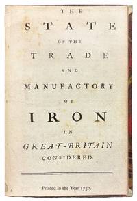
175042149London 1750. 8vo. 6 7/8 x 4 1/4 inches. 15 pp. An abridgement of the Interest of Great Britain in supplying herself with Iron circa 1747. Half red morocco and marble paper boards. Marginal notes trimmed<br/> <br/> A conflicted call for economic protectionism on the eve of industrial transformation and a snapshot of British iron trade policy in 1750 caught between timber tariffs and transatlantic competition.<br/> <br/> An important and revealing mid-eighteenth-century pamphlet addressing the British iron industry at a moment of significant economic and technological transition. This work is considered an abridged version of The Interest of Great Britain in Supplying Herself with Iron published circa 1747 and offers a pointed critique of foreign and colonial competition in iron production. The anonymous author provides a rare quantitative estimate of domestic iron output 18000 tons annually and laments the numerous challenges facing British ironmasters including the rising cost and increasing scarcity of timber then still the primary fuel used in smelting. In a notably conflicted argument the tract decries the influx of Swedish iron while expressing even greater alarm over the growth of ironworks in Britain's North American colonies viewing both as threats to the domestic market. Strikingly the pamphlet makes no mention of the use of pit coal i.e. mineral coal in iron manufacturing a technological development that would prove pivotal. This omission is particularly curious given that Lord Dudley had patented the process in 1619 and that Abraham Darby's pioneering use of coke at Coalbrookdale had been underway for over a decade by the time of this publication. The absence of such a reference suggests either a conservative industrial perspective or a lack of awareness of emergent metallurgical practices that would soon transform the industry and pave the way for Britain's dominance during the Industrial Revolution. Referenced by J.R. McCulloch in his A Select Collection of Scarce and Valuable Tracts on Commerce 1859 who found it "curious" for its data and omissions alike this tract provides not only valuable insight into 18th-century economic policy and protectionist sentiment but also a fascinating snapshot of the iron trade on the cusp of technological upheaval.<br/> <br/> ESTC T76989; Sabin 90635. McCulloch The Literature of Political Economy 1845. unknown
1702143641Paris: Nicolas de Fer 1702. Very Good. Paris Nicolas de Fer circa 1702. A hand-coloured engraved map printed surface 225 × 339 mm sheet size 250 × 361 mm. Engraved by Charles Inselin. Light tanning; a few unobtrusive spots and marks; crease to the border in the top right-hand corner with minimal loss to the marginal corner-tip; in very good condition. A map of the Philippines the Indonesian archipelago mainland Southeast Asia as far north as Taiwan and the Mariana Islands from de Fer's 'Atlas Curieux' 1700-1705. Nicolas de Fer unknown
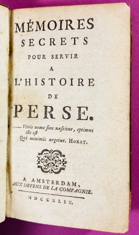
17451441745 Couverture rigide Amsterdam, aux dépens de la Compagnie, 1745. In-12, demi-maroquin rouge à coins, dos à cinq nerfs orné, coins supérieurs légèrement émoussés, reliure du XIXème siècle. Grandes marges, coupes parfois irrégulières sans atteindre le texte. 4 feuillets non chiffrés, 302 pages, (11) pages d'index des noms propres cités. Cet ouvrage, attribué tour à tour à Antoine Pecquet, au chevalier de Resseguier, ou encore à Madame de Vieux-Maisons, "une des femmes les plus méchantes de son temps". BARBIER (Dictionnaire des Anonymes, III, 245) ne consacre pas moins de deux colonnes à cet ouvrage et à ses diverses attributions. C'est en tout cas le premier ouvrage où l'on parle du Masque de Fer. Bon état intérieur, belle reliure, pour cette édition originale.
174519251745 Couverture rigide Amsterdam, aux Depens de la Compagnie, 1749. Un petit volume in-12 (13 x 8 cm), pleine basane fauve marbrée de l’époque, dos à nerfs orné de fleurons dorés, quelques épidermures et rongements sur les coupes, coiffe supérieure arasée, petit manque de cuir en pied au 1er plat. Xxij 386 pages, rares rousseurs et mouillures claires, quelques annotations au crayon, ex-libris manuscrit au 1er contreplat. 3ème édition après l'originale parue en 1745. En tête figure la clé des personnages (17 pages). On sait que dans ces prétendus Mémoires on trouve, sous des noms orientaux, un récit satirique de tout ce qui s'est passé en Europe depuis la mort de Louis XIV, pendant la Régence et pendant les premières années du règne de Louis XV. Bien des personnages, aujourd'hui fort obscurs, figurent dans ces « Mémoires » que le gouvernement de la Restauration crut devoir encore faire saisir et mettre à l'index. (Drujon). Serait d’après Barbier (III, 245) le premier ouvrage où l’on parle du Masque de fer. Bon état intérieur.
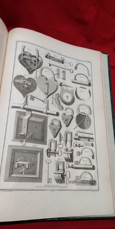
17628659S.l. s.e. 1762 Un volume in-folio plein veau raciné de l'époque, dos à nerfs orné, pièce de titre en maroquin rouge, double-filet doré sur les coupes, réunissant: - M. de Réaumur, Nouvel Art d'adoucir le fer fondu et de faire des ouvrages de fer fondu aussi finis que de fer forgé. 1762. viii+124pp., 7pl.- M. le Marquis de Courtivron et M. Bouchu, De la forge des enclumes. 1762. 11pp., 1pl. - M. Duhamel du Monceau, Art des forges et fourneaux à fer. 1762. 198pp., 9pl.- M. de Réaumur et M. Duhamel du Monceau, Fabrique des ancres. 54pp., 6pl.Épidermures, manque à la coiffe supérieure, léger travail de vers sur les plats et premiers feuillets, mouillure claire en marge supérieure à la fin de l'ouvrage.
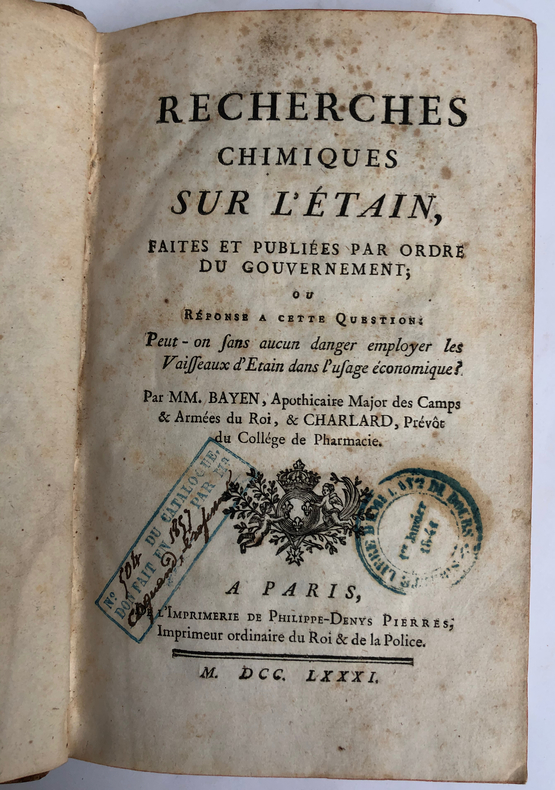
1781ARC-113870Préface, dans laquelle le traducteur indique les problèmes rencontrés par la conversion des mesures suédoises en mesures françaises alors fort nombreuses (pp. I-XVI). Dissertation chimique de l'analyse du fer. Précédée d'un en tête gravé sur bois par Jean Beugnat, qui représente un laboratoire de chimie avec un fourneau et une cornue ; importantes notes de l'auteur et du traducteur (pp. 1-124). Appendice contenant des Observations particulières du Traducteur (pp. 125-186). Mémoire sur les moyens de perfectionner le travail des ancres de marine, par M. Grignon (pp. 187-197). Mémoire qui présente plusieurs moyens de perfectionner les opérations de métallurgie, par M. Grignon (pp. 198-219). Observations sur l'action réciproque que le feu et l'eau ont l'un sur l'autre, par M. Grignon (pp. 220-232). Mémoire contenant les détails, analyses et résultats des expériences faites en 1780 dans les forges du comté de Buffon en Bourgogne et dans la manufacture Royale d'Acier fin de Néronville en Gâtinois, par M. Grignon (pp. 234-284). Paris, Philippe-Denys Pierre, Méquignon, 1781 / 1783, 2 ouvrages en 1 volume, in-8, relié, VIII-285 pages. 1 feuillet non chiffré XVI-286 pages..
1750S376681750. paperback. gebraucht gut Bon état. Ein Einriss 3 cm verso fachmännisch geschlossen Papier altersbedingt leicht fleckig und geknickt sonst GUTES EXEMPLAR. 235 x 345 cm. In französischer Sprache. 112. Par N. de Fer Geog. de Sa Majeste' Catolique et de Monseigneur le Dauphin. Für Ihre Zufriedenheit versenden wir mit DHL und ausschließlich mit Trackingcode für eine sichere Sendungsverfolgung! Weitere Angebote unter antiquariat-kastanienhof paperback
1725M4694Paris 1725. Excellent. Notes: A decorative and beautifully hand coloured title page of the important atlas L'Atlas Curieux ou Le Monde" by Nicholas de Fer. Size : 220x335 mm 8.625x13.125 Inches Coloring: Hand Colored Category: Maps Misc Curiosities Title Pages Games etc. unknown
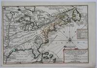
1705M4344Paris 1705. Excellent. Notes: This decorative map focuses on the French possessions in North America. The treatment of French Florida is intriguing. The map shows the United States of America and parts of Southern Canada East of the Mississippi river.<br>"Territorial expansion of New France had reached the Mississipi River with the establishment of the first European settlement at Fort Maurepas by Pierre Le Moyne d'Iberville in 1699 sixteen years after La Salle had reached the mouth of the river. This attractive map from 'L'Atlas Curieux ou le Monde' paris 1705 although containing geographical errors has many interesting historical notes" -The Macdonald Stewart Foundation Size : 232x342 mm 9.125x13.5 Inches Coloring: Hand Colored in Outline Reference: The Macdonald Stewart Foundation "La Decouverte du Monde Cartographes et Cosmographes" Map # 44; McCorkle 702.2 Category: ; Maps North America Great Lakes; Maps Canada; Maps Canada East; Maps United States East; Maps United States South unknown
1705M4627Paris 1705. Very Good. Size : 230x340 mm 9x13.375 Inches Coloring: Hand Colored Category: Maps City Maps; Maps Europe United Kingdom England London unknown
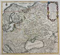
1711M4915Paris 1711. Very Good upper and lower margin have been extended. Laid on acid free paper for long term preservation. Notes: Stolen Size : 520x565 mm 20.5x22.25 Inches Coloring: Original Outline Coloring Category: ; Maps Europe Poland Lithuania; Maps Europe Ukraine unknown
1705M4699Paris 1705. Excellent. Size : 245x340 mm 9.625x13.375 Inches Coloring: Hand Colored Category: Maps City Maps; Maps Europe Austria unknown
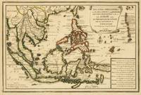
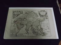
1722biblio10<p>Engraved double page map 28" x 20" wide margins hand colored in outline two uncolored pictorial cartouches. Expert and nearly invisible repairs along centerfold normal aging; about near fine. Impression is bright and clean. Nicholas De Fer 1646-1720 was a highly respected and prolific French cartographer whose maps were valued for their decorative appeal. Around 1690 he was made the geographer to the Dauphin and published his first atlas. He would become geographer to other high-ranking individuals in French and Spanish society. The present map is detailed and attractive map of Asia with a cartouche showing Chinese at the upper left and Indians in the upper right. The map covers a lot of territory showing Arabia and the Persian Empire in the West and Japan in the east but goes as far south as the Isle of Borneo and Java. Part of Eastern Europe is also visible. Library missouri website.</p> books
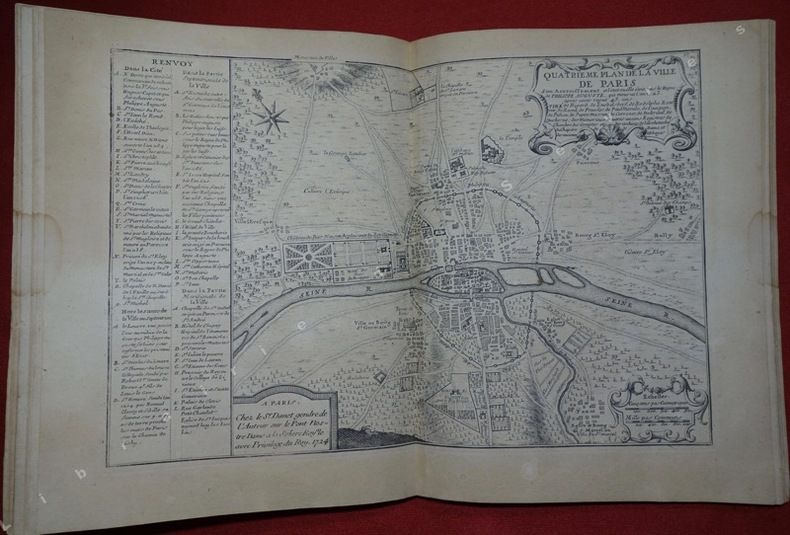
1724197811724 Sans page de titre, Paris,( chez le S.r Danet, 1724), in-4 composé de 17 feuillets comportant 9 plans de Paris et 8 notices gravées, de format 38,5 cm x 26 cm, pliés en 2 et montés sur onglets, l'ensemble placé dans une ancienne reliure de l'époque (plus courte), de plein velin ivoire avec titre de maroquin rouge dans la hauteur du dos, Le dernier plan qui n'est pas accompagné de notice comme les précédents est un " Plan de la conduite des eaües des fontaines publiques de la ville de Paris" daté de 1716, anciennes réparations à quelques pages, bon ex.
1705180573Paris: Published by the author 1705. First Edition . Hardcover. Very Good/No Jacket. Wide 8vo. An atlas comprising 19 maps 1. Des cercels de Longitude et de Latitude et des Diverses Positions de la Sphere; 2. Carte General du Globe Terrestre et Aquatiques ou Mappemonde en deux Plans-hemisphere 1705; 3. l'Europe Dresee sur diverse Relations; 4. L'Asie Dressee Sur Divers Relations 1705; 5. L'Aftique Dressez sur les dernieres Relations; 6. L'Amerique Meridionale; 7. L'Amerique Septentrionale et les Terres Polaires Arctique; 8. La France Avec Ses Acquisitions Insqu'a l'Annee 1705; 9. Les Environs de Paris 1705; 10. Les XVII Provinces des Pais Bas Divisees 1705; 11. Les Isles Britanniques ou Sont les Royaumes D'Angleterre D'Ecosse et D'Irleland avec les Costes Septentrionales de France et Celles de Pais Bas; 12. Suede Norvegue et Dannemarck 1705; 13. Les Estats de la Couronne de Pologne 1705; 14. L'Allemagne Divisee En Dix Cercles Dressee sur les Derniers memoires; 15. Estats du Grand Duc de Moscovie suivant les derniere relations; 16. Hongrie ou Partie Septent de la Turque en Europe; 17. L'Espagne Divisee en Galice Asturies Biscaye Navarre Leon Vielle et Nouvelle Castille Arragon Andalousie Mursie Valence et Catalogne avec Les Isles Majorque Minorque et Yvica au Roy d'Espagne; Le Portugal et L'Algarve avec Roy de Portugal; 18. L'Italie Divisee en ses Pricipaux Estats; 19. Partie Mediridionale de la Turquie D'Europe ou La Grece. Each map has a written descritpion in French. The first 2 pages are lacking the paper on the right-hand edge and have been repaired. The remainder of the maps and text are in very good original condition. A newer binding in 3/4 brown calf over brown boards with marbled endpapers with the bookplate of Antonio Barrette on the blank ffep. An excellent copy of a very scarce work. <br/> <br/> Published by the author hardcover
170219554Paris: N. de Fer 1702. Other. One old crease in the paper else in very good condition. 232 by 349mm 9 by 13 inches. 232 by 349mm 9 by 13 inches. Hand-Colored Original Copperplate Engraving by Nicolaus de Fer depicting Cologne. Published Paris N. de Fer 1702. Sheet: 232 by 349mm 9 by 13 inches. A fine and original hand-colored example of de Fer's celebrated cartographic work documenting this region of Germany with the precision and decorative artistry characteristic of the 17000s. Nicolaus de Fer was a cartographer active in the 1700s working in the tradition of European copper-engraved cartography. Their maps are valued by collectors for their historical accuracy and decorative quality.This original copperplate engraving with original hand coloring depicts the region of Cologne published in Paris N. de Fer 1702. The map records the political and geographic boundaries of the region as understood in 1702 offering a fascinating window into the history of German territorial organization. Sheet measures 232 by 349mm 9 by 13 inches. In excellent condition. Ready to frame. N. de Fer unknown
1705M1429A detailed map of Normandy also showing the islands of Guernsey Jersey and part of Brittany.<br /> From "L'Atlas Curieux ou le Monde Represente ans des Cartes Generales et Particulieres du Ciel et de la Terre..."
1722biblio10<p>Engraved double page map 28" x 20" wide margins hand colored in outline two uncolored pictorial cartouches. Expert and nearly invisible repairs along centerfold normal aging; about near fine. Impression is bright and clean. Nicholas De Fer 1646-1720 was a highly respected and prolific French cartographer whose maps were valued for their decorative appeal. Around 1690 he was made the geographer to the Dauphin and published his first atlas. He would become geographer to other high-ranking individuals in French and Spanish society. The present map is detailed and attractive map of Asia with a cartouche showing Chinese at the upper left and Indians in the upper right. The map covers a lot of territory showing Arabia and the Persian Empire in the West and Japan in the east but goes as far south as the Isle of Borneo and Java. Part of Eastern Europe is also visible. Library missouri website.</p>
1705356958Paris. 1705. Good old repair to right margin smoke stains to top margin no affecting the image short tears to lower margin. 26.5x29x0.1 cm. Image size: 21x32.2 to neatline. Uncolored engraved map of Duchy of Milan by the prolific French mapmaker. weight: 0.1 lb. unknown
170423542Paris: N. de Fer 1704. Other. In very good condition. 244 by 345mm 9½ by 13½ inches. Copper engraving uncolored as published. N. de Fer unknown
172426462Carte gravée au format 60 x 46 cm, Chez le Sr Danet, Gendre de l'Auteur sur le Pont Notre Dame à la Sphère Royale, 1724, à l'échelle de 500 pas communs
1705279621705 Paris, 1705 - Blatt-Maße: ca. 27 x 38 cm. -- gut erhalten. || Original copper engraved map from 1714.