Stahl (Georg Ernst ; 1660-1734) :Livre Rare Book

199 résultats
176621550Paris, Pierre-François Didot, le Jeune, 1766 ; in-12, veau marbré, dos lisse à faux nerfs dorés, décoré et doré, pièce de titre grenat, tranches rouges (reliure de l’époque) ; [8], 392 pp.
17853860Aus dem Schwedischen übersetzt von Johann Gottlieb Georgi. 2 Bände. Mit 2 gest. Tafeln. Berlin, Haude & Spener, 1785. 8vo. (20,2 x 11,2 cm). 1: XVI, 512 S. 2: 4 Bll., 456 S., 19 Bll. Register. Gesprenkelte Kalblederbände d. Zt. mit etwas Rückenvergoldung u. grünem Lederrückenschild.
1722152321722 reliure plein veau havane in-quarto carré (binding full calfskin in-quarto), dos 5 nerfs (spine with 5 raised bands) - entre-nerfs à double filets or à fleuron au fer évidé et rinceaux aux angles avec des petits fers en remplissage (between the raised bands double gilt lines - floweret with hollowed out blocking stamp - with foliages executed in the curved lines in angles - with small blocking stamp in filling) - pièce de titre comportant le titre abrégé de l'ouvrage sur fond havane clair (label of the title with the title abbreviated by the work) - rinceaux en tête et en pied (top and at the foot of spine with foliages carried out with the curved line), petits manques de cuir sur le dos (missing pieces of leather on the spine), coiffe supérieure légèrement accidentée (head of the spine damaged), coiffe inférieure manquante (is missing tail of the spine), charnière du quatrième plat fortement épidermée jusqu'au carton (joint of the back cover with strongly scratches up to the cardboard), coins de queue fortement écornés (corners of the bottom strongly dog-eared), roulettes à froid sur les coupes (fillets with blind-stamping decoration on the cuts), toutes tranches peignées (all painting edges), pages de garde peignées (painting endpapers), texte à manchette (marginal note), illustrations : orné de bandeaux - lettrines et de culs-de-lampe et gravures hors-texte (illustrations : illuminated of headpieces and dropped initials and of tailpieces and illustrations full page engravings), cicatrices de mouillures (scars of waterstains), galeries de vers en particulier en fin d'ouvrage atteignant le texte mais sans conséquence sur sa compréhension (worm's gallery in particular at the end of work on the text but without consequence on its understanding), 9 feuillets de pièces liminaires (9 leaves of introductory pieces) + 566 pages + 1 feuillet (1 leaf), 1722 à Paris Chez Michel Brunet - Grand'Salle du Palais au Mercure Galant,
175412504Notes de Charles Rollin.Texte en latin. Plein veau moucheté d'époque, dos longs très ornés avec un fer à l'oiseau. Très bon Paris Estienne 1754 2 volumes in-12°
1702237451702 Format (23 x 30 cm), sous vitre et cadre doré moderne (31 x 38 cm).
1760M7182Paris: Desnos c. 1760. Very Good. Notes: These maps was originally designed by de la Hire 1640-1718 in 1705. Size : 461x461 mm 18.15x18.15 Inches Coloring: Hand Colored Reference: Tooley III:72 Category: Maps Celestial; Desnos unknown
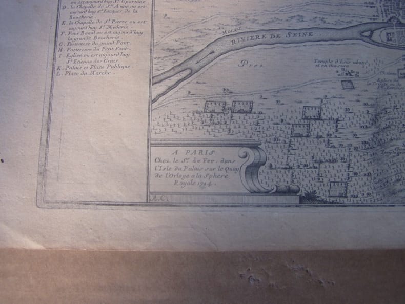
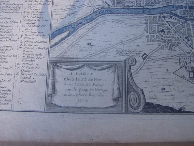
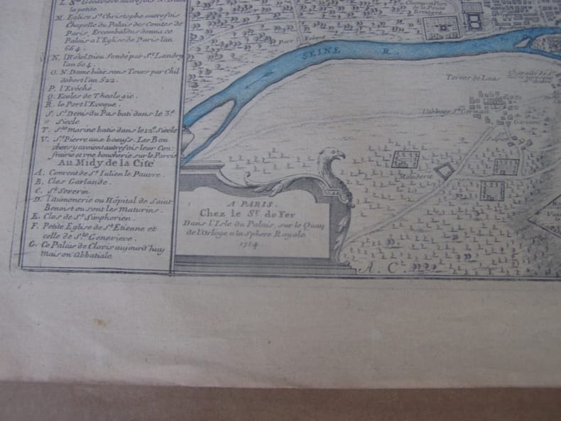
1714279201714. A Paris : Chez le Sr. de Fer, dans l'Isle du Palais, sur le Quay de l'Orloge a la Sphere Royale, 1714. Size with margins : 37,5 x 25,4 cm / 14,5 x 9,8 inches
1714279191714 A Paris : Chez le Sr. de Fer, dans l'Isle du Palais, sur le Quay de l'Orloge a la Sphere Royale, 1714.Size with margins : 37,5 x 25,4 cm / 14,5 x 9,8 inches
1714279171714 A PARIS Chez le Sr. De Fer, dans l'Isle du Palais sur le Quay de l'Orloge a la Sphere Royale 1714. Size with margins : 37,5 x 25,4 cm / 14,5 x 9,8 inches
1714279181714 A Paris : Chez le Sr. de Fer, dans l'Isle du Palais, sur le Quay de l'Orloge a la Sphere Royale, 1714.Size with margins : 37,5 x 25,4 cm / 14,5 x 9,8 inches
1705B2350Paris: Nicolas de Fer c. 1705. Upper fore-corner of the Toulon Grenoble St. Esprit Verceil and Veue de Verue plates all repaired professionally; otherwise a very good copy text and maps are clean and crisp. Binding: Recent ½ calf with contemporary marbled boards spine in five compartments of raised bands gilt title on two endpapers renewed. With 172 engraved plates by Nicolas de Fer and 8 in-text plates including the title. Notes: Introduction a la Fortification was a famous atlas at its timefirst published in 1690-1695. <br>The author Nicolas de Fer inherited his father’s cartography business. Being a prolific cartographer his reputation grew such that he became the official geographer of King Louis XIV of France and King Philip V of Spain. He made maps of both North America and Europe notably including maps of the War of Spanish Succession. <br> Size: Oblong folio Illustration: With 172 engraved plates by Nicolas de Fer and 8 in-text plates including the title. Lacks 9 plates St. Malo Environs de St. Malo Gravelines Nieuport Combat de Leuse Liege Camp de Weil and Civita Vecchia; but has 5 extras not called for in the plate list Aire Hesdin Menin Batavia and Quebec. Pages: P. plate index title engraved maps and text plates. Category: Book Atlas & Cartography; Book Military Nicolas de Fer hardcover
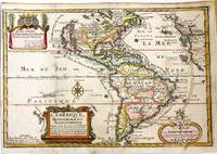
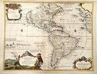
1717M11008Paris: Chez l'autheur dans l'Isle du Palais sur le Quay de l'Orloge a la Sphere Royale 1717. Very Good. Notes: Beautiful example of the map of the Americas by renowned 17th century French cartographer Nicolas De Fer.<br><br> Size : 225x337 mm 8.86x13.27 Inches Coloring: Hand Colored Category: Maps North America; Maps South America Countries; Chez l'autheur dans l'Isle du Palais sur le Quay de l'Orloge a la Sphere Royale unknown
1705M11362Paris c.1705. Very Good. Notes: Detailed French map of the Americas with decorative cartouches.<br>Nicolas de Fer 1646–1720 was a French cartographer and geographer. He also was an engraver and publisher. His work was most often praised for being beautiful and artistic. Size : 464x600 mm 18.27x23.62 Inches Coloring: Hand Colored Category: Maps North America; Maps South America Continent; unknown
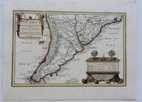
1704M5174Paris 1704. Excellent. Notes: French Map of Chile by renowned French cartographer. Size : 235x340 mm 9.25x13.375 Inches Coloring: Original Outline Coloring Category: Maps South America Countries; unknown
1760M5799Paris: Desnos 1760. Very Good. Notes: French map of Poland Lithuania and the surrounding region.<br>1760 edition of rare Nicolas De Fer's map. Size : 480x590 mm 18.875x23.25 Inches Coloring: Hand Colored in Outline Category: Maps Europe Poland Lithuania Desnos unknown
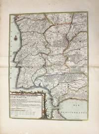
1790M10223Paris: Chez Desnos 1790. Very Good. Notes: Detailed map of Portugal and western Spain showing Gibraltar region. Size : 580x432 mm 22.83x17.01 Inches Coloring: Original Hand Coloring Category: Maps Europe Portugal; Maps Europe Spain; Chez Desnos unknown
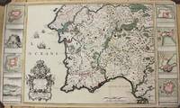
1706M6655Paris c. 1706. Very Good;. Notes: Cartouche in upper right corner depicts the shield of the Royal coat of arms of the United Kingdom three hunting dogs and a cockfight. The cartouche in the upper left defines the geographical coordinates of London Edinburgh Dublin and Dunkirk. Size : 460x486 mm 18.11x19.13 Inches Coloring: Original Outline Coloring Category: Maps Europe United Kingdom; Maps Europe Ireland; unknown
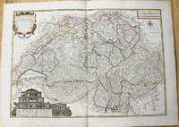
1764M10199Paris c. 1764. Very Good. Notes: An important and decorative map of Switzerland published in mid 18th century. The map originally was drawn by De Fer and later updated and improved by Desnos. Size : 485x670 mm 19.09x26.38 Inches Coloring: Hand Colored Category: Maps Europe Switzerland; unknown
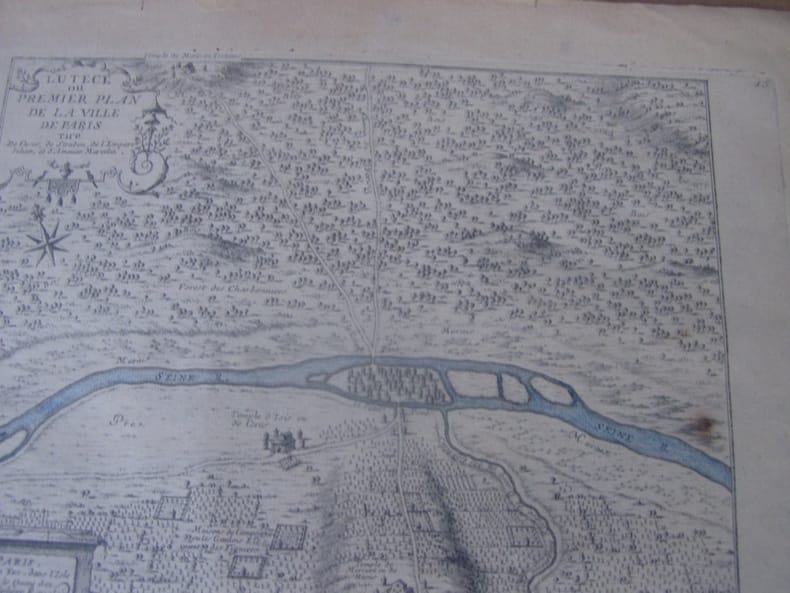
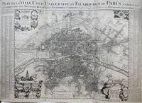
1720M9651Paris: Nicolas de Fer c. 1720. Very Good backed on 19th century paper. Notes: A large-scale and detailed map of the city of Paris and its surroundings during the early 18th century. The map has ornate cartouches in all corners and indexes in the left and right margins. <br>Nicolas de Fer 1646–1720 was a French cartographer and geographer. He also was an engraver and publisher. His work was most often praised for being beautiful and artistic. Size : 637x905 mm 25.08x35.63 Inches Coloring: Hand Colored Category: Maps City Maps; Maps Folding Maps; Maps Europe France Paris; Nicolas de Fer unknown
171458931714. : 7 In four places along the edges of the map some discoloration from tape is visible. This does not affect the map itself. Dimensions of the map excluding the white borders: Height: 22 cm Width: 325 cm Height cm: 25 CM Width cm: 375 CM unknown
1704M10805Paris: St. Gaspar Baillieu 1704. Very Good backed on acid free tissue paper for long term preservation. Notes: Fine large scale map focused on Southern Portugal and Southern Spain. The map is surrounded by inset maps of Olivenca Castello Ferreire Aronches Badaioz Lisbonne Setubal Chateau St. Iulien Evora.<br> Size : 561x940 mm 22.09x37.01 Inches Coloring: Original Hand Coloring Category: Maps Europe Spain; Maps Europe Portugal; St. Gaspar Baillieu unknown
170123030Paris: Nicolas De Fer 1701. First Edition. Very Good. Ginville Vincent de. Ginville Vincent de. First Edition. Paper size 42.5 cm x 28.5 cm. Plate mark 34 x 22.5 cm. Marked "sculpsit Vincent de Ginville" lower left. Paper clip mark just to the plate mark upper margin '109' inked upper right corner some marginal chipping to the paper marginal old pencil price lower right. A few unobtrusive spots inside the plate marks. Copperplate engraving with later hand color. From Nicolas De Fer's Atlas Curieux. Highlights locations of Indian villages found by La Salle during his explorations of the coastal areas of the United States. LOC online We see the Gulf of Mexico Cap de la Floride and many inland village names. A nice map showing some early history of the southern United States. Nicolas De Fer unknown books
170123030Paris: Nicolas De Fer 1701. First Edition. Very Good. Ginville Vincent de. Ginville Vincent de. First Edition. Paper size 42.5 cm x 28.5 cm. Plate mark 34 x 22.5 cm. Marginal paper clip stain inked '109' upper right corner some marginal chipping to the paper and old penciled price lower right. A few unobtrusive spots inside the plate marks. Copperplate engraving by Vincent de Ginville with later awfully bright hand color. This map would frame up nicely. There appears to be several versions of this map. The David Rumsey Collection has an example dated on the cartouch 1705 which he notes as being from Nicolas De Fer's Atlas Curieux published later. <br /> <br /> The Library of Congress has an example of the map offered here with the 1701 date and a separate page with explanations of the map. We don't know where this 1701 example came from separately issued or another atlas. The map highlights locations of Indian villages found by La Salle during his explorations of the coastal areas of the United States. We see the Gulf of Mexico Cap de la Floride and many inland village names. A nice map showing some early history of the southern United States. It includes parts of modern-day Louisiana Mississippi Alabama and Florida as well as the Bahamas and Cuba. Nicolas De Fer unknown
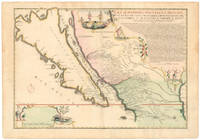
1720NL-01644<p>This exquisite and scarce map was published in Paris in 1720. The maker Nicolas de Fer was one of the most prolific and influential French cartographers of the late 17th and early 18th centuries who worked for the French King and <em>dauphin </em>crown prince.</p><p>The map depicts the most iconic cartographic myth in the European exploration of the Americas: California as a large island. This notable misconception impacted the accuracy of mapmaking for centuries and full acceptance that California was part of the continental mainland was not achieved until the mid-18th century.</p><p><strong>But why '<em>Nouvelle Caroline</em>'</strong></p><p>We can actually start at the eastern edge of the map where we see the great Mississippi River emptying into the Gulf. At first its position seems somewhat anachronistic as it follows an antiquated 17th-century notion of the Mississippi Delta located far to the west. Cartographers began rejecting this configuration after French explorer Sieur de la Salle navigated the entire lower river in 1682. Yet De Fer's choice to position the delta further west was in fact a keen political move executed in service to his patron the <em>dauphin</em>. By positioning the Mississippi so far west as to include it in this map he automatically implies a significantly enlarged French Louisiana even if it remains unseen.</p><p>The French were gradually beginning to encroach on the silver-rich regions in Upper Mexico which at that time belonged firmly to New Spain. But a great upheaval had recently taken place in Spain altering the entire political landscape of Europe. When the Spanish King Charles II died in 1700 this closed the chapter on the powerful dynasty of the Spanish Habsburgs following a long period of decline. When power subsequently transferred to Charles' nephew Phillipe of Anjou who became Philip V of Spain it passed from the Habsburgs to the Bourbons to which the French kings belonged. It was almost a personal victory for De Fer as Philip was the son of the French <em>dauphin</em> who in turn was De Fer's main patron.</p><p>A political element of cartographic land grabbing is echoed in the map's title which refers to the island as 'California or New Carolina' <em>Nouvelle Caroline</em>. This bold new proposal for an alternate name was loaded with political meaning. Following the Spanish succession some still challenged Philip's claim just as some feared an amalgamation of French and Spanish interests and power in the New World. De Fer's maps were part of the counter-propaganda touting the ambitions of his patrons as fact to exaggerate their global influence. While the term 'California' was very much tied to the envisioned island renaming the entire region <em>Nouvelle Caroline</em> New Carolina would make borders more fluid and national ownership less defined.</p><p>Beneath the title De Fer has included extensive text that constitutes an invaluable record of late 17th century missions and Indian villages in this remote part of the New World. The inclusion of this text helped cement De Fer's map as a seminal contribution to West Coast cartography. The mapmaker seems to have been well aware of the importance of this annotation as he surrounded it with fascinating vignettes depicting scenes of Native American life and the abundance of the land. He further compliments these scenes with depictions of fauna in the lower-left corner including an aardvark a sloth and a pelican or spoonbill set around the scale bar.</p><p><strong>Census and details</strong></p><p><em>La Californie ou Nouvelle Caroline </em>was published in the <em>Atlas ou recueil de cartes gegraphiques</em>. It is not only one of the most significant depictions of the California island theory but also its largest separate <em>i.e.</em> regional representation on a printed map. It is essentially an enlarged and far more focused version of his <em>Californie et Nouveau Mexique</em> published twenty years prior in <em>L'Atlas Curieux ou le Monde</em>.</p><p>De Fer's California maps drew on information provided by the Jesuit missionary Father Eusebio Kino who traveled throughout the region in the 1680s and 90s and made extensive observations including the compilation of his own maps. We know that Kino was a significant source because the map's title is taken directly from his original expedition notes and important discoveries made by Kino – such as the mouth of the St. Thomas River discovered in 1684 – have been copied directly onto De Fer's map from his original. The source is hardly a secret: De Fer uses the inset text in the upper right corner to note how his work was drawn from a map that came via the Viceroy of New Spain to the <em>Academie de Sciences in France</em>. The text also provides a history of California's exploration and subjugation up until 1695 – including the initial discovery of Baja California by Hernan Cortes – further underscoring the original author.</p><p>De Fer made several significant changes for the present map. He plots more than 300 towns and villages including many locations on the mainland and in what today is known as New Mexico and southern Arizona. The toponyms generally confirm the influence of Father Kino. Among the many places listed we find the ruins of Casa Grande identified by Kino in 1694 and appeared on this map for the first time. Important towns like San Diego Santa Fe and Mexico City are noted clearly if not prominently. We even see the first inkling of the settlements that soon would grow into Tucson and Phoenix. The spelling of many of the place names also changed on this new map just as De Fer incorporated the first Indian toponyms along the Gila River.</p><p>While the southern coastline is relatively accurately documented there are almost no place names present along the northern mainland or on the eastern side of the island reflecting how little was known about this region at the time. Along California's exterior coast we do find some toponyms in many cases related to the coves and inlets that ships would have frequented. Yet even at this early stage we are already seeing multiple toponymic references to Saint Francis San Francisco in Spanish in the island's northern part.</p><p>Turning to the toponyms of the northern interior we find <em>Gran Quivira</em> which refers to the legend of Cibola or the Seven Cities of Gold supposedly discovered by the Spanish explorer Francisco Vasquez de Coronado in 1539. While we know this terminology from many iconic early West Coast charts like Cornelis de Jode's famous map of the Northwest Pacific 1593 the myth had such pervasive power that the notion persisted well into the 18th century. In this case it has even been complimented by a second quasi-mythological eldorado reference in the toponym <em>Gran Teguaio Coqui</em>. This term originates from the <em>Benevides Memorial </em>1630 which describes it as rivaling Quivira in wealth.</p><p><strong>Context</strong></p><p>Between 1500 and 1747 confusion ensued over whether or not California previously documented in medieval folklore as a mysterious island filled with an abundance of gold was considered part of a series of various mythical islands in an unknown ocean. The "island theory" was perpetuated by Spanish explorers including Juan de la Fuca who suggested in reports published in 1592 that the large opening identifying the mouth of Mexico's Baja peninsula joined a grand bay in the northern part of the continent.</p><p>In 1622 Henry Briggs produced a map based on these reports and the travels of Samuel Purchas. Published in London Briggs' map was accompanied by an article that referred to California as a large island off the coast of <em>Newe Spaine</em>. This "island" appeared to have a rough and rocky coastline complete with smaller islands offshore. Brigg's map became the standard outline for depicting California's insularity and was copied and incorporated onto the maps of influential publishers and geographers throughout Europe.</p><p>Father Kino would eventually dispel the Island of California myth when he discovered Baja California was indeed landbound. Father Kino published this insight in Paris in 1705 some fifteen years before our map was issued quickly becoming the authoritative source for rejecting the island hypothesis. The notion stubbornly persisted despite Kino's publication of his latest observations and map. In addition to influential French cartographers like Nicolas de Fer and Philippe Buache one of the great English mapmakers of the period Herman Moll remained convinced of California's insularity. He even went so far as to claim that he had met sailors who had circumnavigated it. Soon however even the most ardent defenders would have to yield when Ferdinand VII of Spain decreed California to be a peninsula in 1747.</p><p>Cartographers:</p><p><strong>Nicolas De Fer 1646–1720</strong> was a French cartographer and geographer who also worked as an engraver and publisher. He was renowned for his massive output and his pleasant visual designs. He was the son of a Parisian cartographer and began apprenticing at an early age. By twelve however he shifted his apprenticeship to the closely associated field of engraving – a move his father no doubt encouraged as it might enhance his competitive position on the market with his son as a trained engraver.</p><p>De Fer's father died in 1673 but Nicolas did not take over the company until 1687 at which point it had been virtually run into the ground. Nevertheless Nicolas had a knack for business and soon turned things around. By 1690 he was so successful that he won employment as the official geographer to Louis <em>Le Grand Dauphin</em> of France and son of the reigning French king Louis XIV. Soon after with support from the Spanish and French courts De Fer was appointed the official geographer for King Louis XIV. In 1720 shortly before his death he was even appointed royal geographer to Philip V king of Spain.</p><p>De Fer's popularity in the Bourbon royal circles was primarily due to his appreciation of the propagandistic effects of strategic cartography. But no doubt his keen sense of aesthetics helped as well. Whatever the case his maps were hugely popular well-funded and widely distributed. He was impressively productive publishing over 600 sheets from his atelier and covering everything from town plans to world maps. Many of his maps rode the political conjunctures of the age. Hardly would a territory have been won or surrendered before De Fer's atelier was working on a map delineating the new realities.</p>
1705R300113009A PARIS CHEZ L'AUTEUR DANS L'ISLE DU PALAIS A LA SPHERE ROYALE. 1705. In-4. Cartonné. Etat d'usage, Plats abîmés, Dos satisfaisant, Intérieur frais. Atlas comportant 18 cartes en noir et blanc et 18 pages de texte (textes sur deux colonnes) - DESCRIPTIONS DES CARTES : Correspondance du globe terrestre a la sphère céleste situation des habitans du monde des cercles de longitude et de latitude et des diverses positions de la sphère - carte générale du globe terrestre et aquatiques ou mappemonde en deux plans hémisphere - L'Europe dressée sur diverse relations - L'Asie dressée sur divers relations - L'Afrique dressez sur les dernières relations - L'Amérique Méridionale - L'Amérique septentrionale et les terres polaires artiques - La France avec des acquisitions jusqu'a l'année 1705 - Les environs de Paris - Les XVII Provinces des Païs Bas divisées en Provinces Unies en Païs Bas catholiq et en Païs Bas François - Les Isles Britanniques ou sont les Royaumes d'Angleterre d'Escosse et d'Irlande avec les costes septentrionales de France et celles des Païs Bas - Suede Norvegue et Dannemarck - Allemagne divisée en dix cercles dressées sur les derniers memoires - Les Estats de la couronne de Pologne - Estats du Grand Duc de Moscovie suivant les derniere relations - Hongrie ou partie sepentrionale de la Turquie en Europe - L'Espagne divisée en Galice Asturies Biscaye Navarre Leon Vielle et Nouvelle Castille Arragon Andalousie Mursi Valence et Catalogne avec les Isles Majorque Minorque et Yvica - L'Italie divisée en ses principaux Estats - plats cartonnés - coins frottés - annotations sur la page de garde - 10 photos disponibles.. . . A l'italienne. Classification Dewey : 840.05-XVIII ème siècle