FER, Nicolas deBiblio.com
11 843 résultats
1695ABC_49413Paris: chez lauteur / van Loon 1695. Approximately 114 x 165 cm each. Copperplate engravings in original outline colour tissue-backed for stability laid down to modern cartographic linen. All with title banner dated 1698 with the Royal Privilege and text panels dated 1703. Each map printed on four joined sheets with title surmounted and engraved text panels at sides and bottom. A magnificent set of five Enlightenment wall maps of the continents & world all in early states: the only known set of all five unknown in any public or private collection. In the late 17th century mapmaking was emerging from an equal focus on the decorative and descriptive to a more analytic sensibility. Nicolas de Fer 1646-1720 successfully navigated the early Enlightenment era with these monumental wall maps created with the patronage of the Dauphin of France. The dramatic cartouches and vignettes in the maps are masterpieces of baroque imagery capturing the people wonders resources and cultures of faraway lands eagerly sought by Europeans during this dynamic period. A very limited number of large wall maps were produced by the major cartographic houses for the nobility and for wealthy merchants to satisfy curiosity about the world beyond Europe. Grand wall maps such as these were usually mounted for display and their exposure led to the great majority of examples from this period having been lost; the incidence of this type of map passing down to our era is astonishingly small. 1 America: LAmerique divisee selon letendue de ses principales parties et dont les points principaux sont placez sur les observations de messieurs de lAcademie Royale des Sciences 1698. Second state of 1698 first edition adding the dedication to the Dauphin within an ornamental cartouche. One of the most glorious cartographic expressions of the spirit of 17th century French expansionism in North America. The geography is of the type in fashion at Paris during the short interval between La Salles descent of the Mississippi in 1682 and the founding of Louisiana in 1699. De Fer properly aligned Hudson Bay above the Great Lakes which are portrayed with exceptional accuracy and the southern reaches to the Great Lakes are better aligned with the east coast. The map shows advanced knowledge of the Mississippi River drainage although still emptying in the Gulf of Mexico in Texas too far to the west following the school of Coronelli. Two of the most iconic 18th century images of America those of beavers at work and of a cod-fishery were introduced on this map before being made famous by the English cartographer Herman Moll. The beaver scene shows dozens of the industrious creatures against a backdrop of Niagara Falls which is most likely based on Hennepins first printed view of the falls published a year earlier in 1697. 2 Africa: LAfrique divisée selon letendue de ses principales parties et dont les points principaux sont placez sur les observations de messieurs de lAcadémie Royale des Sciences 1698. The African continent on a fantastic scale with extensive annotations and panelled legends throughout; dedicatory cartouche in the southern Indian Ocean. The side panels have extensive text entries for the division of the continent cities islands capes rivers mountains and a lengthy description of the source of the Nile. Richly decorated with more than 20 elaborate scenes showing art industry clothing customs farming hunting trade battle and landscapes. Numerous animals include ostrich monkey crocodile lion elephant and camel. With a plan of the Dutch fort at the Cape of Good Hope in a draped paneled inset. The Arabian Peninsula is shown in its entirety. Based in part on the work of de lIsle it shows an early conception of the Middle East: in particular it omits the Sinai Peninsula included in several of de Fers earlier efforts. Among the toponyms along the coast of the Gulf are Abadan Sur Ahsa Janama Bahr El Catif Bischa Borou Godo Vodana Calba Dadana and Pinder. Although the coastlines are well mapped there is a notable lack of understanding of the interior: the Niger delta is shown divulging on the west coast instead of the Gulf of Benin while the massive extent of the Congo rivers drainage basin is here only hinted at. The Nile is finally freed from the twin Ptolemaic lakes and begins to take on its more accurate course.3 Asia: LAsie divisée selon letendue de ses principales parties et dont les points principaux sont placez sur les observations de messieurs de lAcadémie Royale des Sciences 1696. The earliest known state dated 1696 in the dedication. Includes the rare letterpress historical text panels dated 1703. Much of the continent is well-charted based largely on Dutch for the Philippines Malaysia Southeast Asia and Jesuit sources for areas such as China. The coastlines north of Korea correctly shown as a peninsula curving west and northward begin and end in ambiguity. Inset map of Arctic Asia; two inset maps of Northeast China based on the writings of the Jesuits Martino Martini and Ferdinand Verbiest. The richly decorated borders depict the people art religion commerce and cultures of Asia. Vignettes show Chinese Japanese Turks Indians Tartars Philippines inhabitants of the Molucca and Sunda islands Ceylonese Arabs peoples from Goa and Mongolia Armenians Georgians people from Golconda Malaysia Siam Cochin and Tonkin. Among the images are those of the faithful during the Hajj visiting the Kaaba at Mecca. The rare letterpress panels provide extensive text references; rivers towns capes lakes and straights including more detailed descriptions of Turkey Arabia China Persia India Russia and Arabic islands in the Indian Ocean. 4 Europe: LEurope divisée selon letendue de ses principales parties et dont les points principaux sont placez sur les observations de messieurs de lAcadémie Royale des Sciences 1695. The earliest known state dated 1695 within the dedication. With 16 legends in elaborate Baroque vignettes describing the French Polish Germans Austrians English and other peoples the vignettes interspersed with views of cities hunting coats of arms pageantry and other fascinating glimpses of a dynamic continent with culture flowering everywhere. The side panels have extensive text entries for the division of the continent countries principalities nobility cities principal islands capes rivers mountains etc. Widely acknowledged as one of the foremost French cartographers of the late 17th century Nicolas de Fer published more than 600 maps and many atlases documenting French fortified towns strongholds and the explorations and discoveries of new territories. Unlike most Dutch cartographers who mainly made maps for navigational purposes he worked in the French decorative style creating a total of 26 large wall maps to adorn walls in the palaces and castles of European royalty clergy and wealthy merchants.A superb set previously unobtainable: no other set of the de Fer wall maps of the continents in their earliest incarnation with or without the side panels other than the present example are known to have survived. Examples of individual continental maps in the earliest states as here rarely appear on the market. Later states of the map often appear without the surmounted title and text panels. No comparable set traced in auction records; an example of the first-state America map alone sold by Cohen & Taliaferro in 2010 commanded $185000.Provenance: Long in an aristocratic collection based near Novara. Acquired in the U.S. trade. Absolutely untouched by facsimile only some reinstatement of paper in text panels and much less so to very minor loss in maps. Old outline colour retouched; cartouches and vignettes with recent colour. Stabilised cracks occasional scuffing overall age toning.l Burden P. The Mapping of North America II no. 744; Dahl E. The Original Beaver Map: De Fers 1698 Wall Map of America in: The Map Collector 29 Dec. 1984 pp. 22-26; Suarez T. Shedding the Veil Singapore 1992 no. 48; not in WorldCat. chez lauteur / van Loon, hardcover
170223526Paris 1702. Oblong 1mo 30 x 37 cm. chez l'auteur" = Nicolas de Fer a false imprint Contemporary tanned sheepskin sewn on 5 cords gold-tooled spine with the title in the 2nd of 6 compartments. Ad 1 with 10 letterpress title pages in red and black for the 10 parts; 5 engraved titles for parts 1-5 that for part 5 repeating that for part 2; plus 234 beautifully engraved plates a few folding with 366 maps and views of fortified cities. Ad 2 with an engraved title page 2 letterpress title pages in red and black and 40 engraved plates including 2 folding labelled A-S in part 1 and T-Oo in part 2. 2 works in 12 parts or volumes bound as 1. Splendid atlas of fortifications of the cities of Europe plus Malta and some other Mediterranean sites combined with a maritime atlas of the French coasts published by Pieter Mortier 1661-1711. Both are based on the similar publications of Nicolas de Fer 1646-1720 and falsely indicate that they were published by him.Ad 1: The atlas of fortified cities of Europe. Many of the plans show the work of the greatest 17th-century masters of the art and science of fortification including Samuel Marolois Simon Stevin and Sébastien Le Prestre de Vauban. The last two parts contain primarily smaller maps printed 4 to the page. Ad 2: The maritime atlas of the coasts of France. It also shows the fortifications along the coasts so it complements the fortifications atlas and was clearly designed to match it in format and style. With the caption of one plate cut off and 2 plates and 1 letterpress title-page somewhat browned. Further in good condition. A couple plates are bound in the wrong volume. A splendid fortifications atlas.l Ad 1: Muller Historieplaten 3034a; cf. Pastoureau Atlas français IX A & H pp. 203-209 213: Paris Fer ed. 1690-1695 & Amsterdam Mortier ed. 1702 with different title; Phillips pp. 256-7 other ed.; Ad 2: Muller Historieplaten 3034a; Pastoureau Les atlas français XVIe-XVIIe siècles Fer VIII B p. 203 cf. pp. 201-203; for Mortier see: Koeman III pp. 4-10 and IV p. 423. unknown
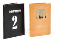
19152787Lisbon 1915. First editon. In bit later decorated bindings. In very good condition. First editon. In bit later decorated bindings. Complete collection of the famous Portuguese avant-garde magazine directed by Fernando Pessoa and Mario de Sá-Carneiro.<br /> <p><br /> The first Portuguese review entirely dedicated to Futurism.<br /> <p><br /> Financial difficulties prevented the publication of the third volume ready for printing.<br /> Despite its short-lived existence the magazine had a decisive influence on Portuguese literature.<br /> On the occasion of its centenary Gallimard Editions published a facsimile edition in French.<br /> The second issue reproduces four "resolutely futuristic" drawings by the painter Santa Rita as well as the famous phonetic poem Poemas sem suporte by Mario de Sá-Carneiro and Chuva obliqua poemes interseccionistas by Fernando Pessoa.<br /> <p><br /> Illustrations and texts by Pessoa Santa Rita Mario de Sa Carneiro Raul Leal Viloente de Cysneiros Armando Cortes Rodrigues and others<br /> <p> <br /> Very rare.<br /> <p> <br /> Collection of Jean-Paul Kahn. unknown
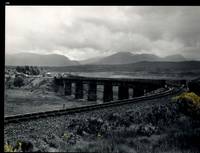
32483AB1974. Scotland 1974-2002. Oblong-Folio 44 cm wide x 36 cm high. Hardcover / Original Full-Leather Folders with stong black cardboards and original tissue-guards. Excellent condition with only minor signs of wear. With hundreds of manuscript annotations on the photography the photography-technique film used and with extensive elaborations on each photograph in these albums. More images on request ! Album 1: Covers the years 1974 1977 and 1978. The West Highland Line is walked from Arrochar a 1977 driving and camping holiday and a 1978 seventeen day touring holiday with many nights sleeping in a car fill the leaves with c. 200 b/w original photographs. Album 2: Covers the years 1991 and 1992. It is noted that 1990 is the fourth year that returning locomotives from the Mallaig line will work south over the West Highland main line. Images of Corrour Summit Glasgow to Fort William trains and many many more bridges viaducts tunnels stations and signalling equipment fill the leaves. c.182 b/w original photographs. Album 3: Covers 1993. More colour photographs now fill the leaves and annotations cease to second half of album. c 270 b/w colour and tinted original photographs. Album 4: Covers 1999 and 2002. Many images from The Highlands Rail Festival in Sept 1999. c.250 b/w and colour original photographs. An extraordinary photographic record and passion project presented in 4 huge well-bound albums containing over 900 fine photographs taken curated and annotated by an unidentified railway enthusiast and talented photographer. The albums span 4 decades recording trips to some of the most scenic and famous rail locations in the UK. The West Highland Line is returned to again and again over the decades and our photographer captures Scotlands most dramatic landscapes and railways as the route passes on its way from Glasgow to Mallaig through sections including Corrour and Rannoch Moor. Albums and contents in fine condition. A tissue guard between every leaf protects the photographs within. A single photograph of a middle aged man among every other photograph which records a detail of the railway is the only clue to the albums previous ownership and perhaps authorship. Partial description by our colleague Dr.Christian White from Christian White Rare Books in Ilkley UK. __________________________________________________________________________________________________________ The West Highland Line Scottish Gaelic: Rathad Iarainn nan Eilean "Iron Road to the Isles" is a railway line linking the ports of Mallaig and Oban in the Scottish Highlands to Glasgow in Central Scotland. The line was voted the top rail journey in the world by readers of independent travel magazine Wanderlust in 2009 ahead of the notable Trans-Siberian line in Russia and the Cuzco to Machu Picchu line in Peru. The ScotRail website has since reported that the line has been voted the most scenic railway line in the world for the second year running. The West Highland Line is one of two railway lines that access the remote and mountainous west coast of Scotland the other being the Kyle of Lochalsh Line which connects Inverness with Kyle of Lochalsh. The line is the westernmost railway line in Great Britain. At least in part the West Highland Line is the same railway line as that referred to as the West Highland Railway. History: The route was built in several sections: Glasgow Queen Street to Cowlairs Junction - Edinburgh and Glasgow Railway Cowlairs Junction to Bowling - Glasgow Dumbarton and Helensburgh Railway later absorbed into the Edinburgh and Glasgow Railway Bowling to Dumbarton Central - Lanarkshire and Dumbartonshire Railway operated by the Caledonian Railway Dumbarton Central to Dalreoch - Caledonian and Dumbartonshire Junction Railway Dalreoch to Craigendoran - Glasgow Dumbarton and Helensburgh Railway Craigendoran to Fort William opened 11 August 1894 - West Highland Railway sponsored by the North British Railway Crianlarich to Oban - Callander and Oban Railway operated by the Caledonian Railway. There is an additional section from Fort William or a junction near Fort William to Mallaig built as the Mallaig Extension Railway. The West Highland Railway approved the construction of the line at their annual meeting in January 1895. The line faced potential closure as part of the Beeching cuts in 1963 and again in 1995 due to reduced revenues. Route description: Shortly after leaving Glasgow Queen Street station and beyond Queen Street Tunnel the line diverges from the main trunk route to Edinburgh Waverley and Perth at Cowlairs and follows a northwesterly course through the suburbs of Maryhill and Kelvindale. Between Westerton and Dumbarton the route is shared with the North Clyde Line to Helensburgh Central before branching northward at Craigendoran Junction towards Garelochhead the section where the West Highland Line itself is generally accepted to begin. It gives high-level views of the Gare Loch and Loch Long before emerging alongside the northwesterly shores of Loch Lomond then climbs Glen Falloch to Crianlarich. The branch to Oban diverges at Crianlarich an important Highland junction of both road and rail and runs through Glen Lochy to Dalmally and through the Pass of Brander to reach salt water at Taynuilt and Connel Ferry before a final climb over a hill to Oban. About three miles five kilometres from Crianlarich the Mallaig and Oban routes both pass through the village of Tyndrum but they are served by separate stations making it an unusually small settlement to be served by more than one railway station. After Bridge of Orchy the line to Mallaig climbs onto Rannoch Moor past the former crossing point at Gorton Crossing to Rannoch station. In winter the moor is often covered with snow and deer may be seen running from the approaching train. The station at Corrour on the moor is one of the most remote stations in Britain and is not accessible by any public road. This is the summit of the line at 1347 ft 410 m above sea level. Carrying on northwards the line descends above the shores of Loch Treig and through the narrow Monessie Gorge. The final stop before Fort William is Spean Bridge. The section between Fort William and Mallaig passes over the Glenfinnan Viaduct through Arisaig with its views of the Small Isles of Rùm Eigg Muck and Canna and the white sands of Morar before coming to Mallaig itself. With the exception of the route between Glasgow Queen Street and Helensburgh Upper and the short section between Fort William Junction and Fort William station the railway is signalled using the Radio Electronic Token Block controlled from the signal box at Banavie station. Notable railway-related features Glenfinnan Viaduct The Horse Shoe Curve between Upper Tyndrum and Bridge of Orchy The Cruach Rock snowshed between Rannoch and Corrour Glenfinnan Viaduct between Locheilside and Glenfinnan The Pass of Brander stone signals between Dalmally and Taynuilt Arisaig is the most westerly railway station in Great Britain West Highland Line in film: Train crossing bridge at Banavie The summit of the line just north of Corrour Glenfinnan Viaduct on the line between Fort William and Mallaig is a filming location for the Hogwarts Express in the Harry Potter series of films. Eddie McConnell's poetic documentary A Line for All Seasons 1970 showcases the line and its history set against the scenery of the western highlands as it changes through the seasons. Corrour features in Trainspotting 1996 directed by Danny Boyle. Source: Wikipedia hardcover
156417hardcover. Dediees a Monseigneur le Dauphin par Sontres Humble et tres Obeissant Serviteur et Geographe De Fer. Beautiful double-page engraved title page 4 38 2 60 28pp. This splendid atlas is illustrated with 32 engraved coastal charts including a folding wind chart and a general index chart of France. The double page maps have delicate outline hand coloring. An engraved divisional title page number 26 entitled "Les Costes de la Mer Mediterranee" is the 33rd plate. Short 4to 9.5 x 7.75 inches 17th Century calf well-worn; neatly rebacked; marbled endpapers red edges. Paris: Chez le Sr. de Fer dans l'Isle du Palais sur Quay de l'Orloge a la Sphere Royale. Avec Pri. du Roy 1690.<br/><br/> Nicolas de Fer 1646-1720 was a prolific cartographer engraver and publisher who took over the family map business from his mother when she retired in 1687. The business flourished and he gained a great reputation in his lifetime and was appointed 'Geographer to the King' in 1690. This original edition the first atlas to bear his name was published in 1690 on the basis of an atlas published in 1634 by order of Cardinal Richelieu by the publisher Tassin who sold his plates in 1644 to Antoine de Fer Nicolas's father. Scarce.<br/><br/> unknown books
156417hardcover. Dediees a Monseigneur le Dauphin par Sontres Humble et tres Obeissant Serviteur et Geographe De Fer. Beautiful double-page engraved title page 4 38 2 60 28pp. This splendid atlas is illustrated with 32 engraved coastal charts including a folding wind chart and a general index chart of France. The double page maps have delicate outline hand coloring. An engraved divisional title page number 26 entitled "Les Costes de la Mer Mediterranee" is the 33rd plate. Short 4to 9.5 x 7.75 inches 17th Century calf well-worn; neatly rebacked; marbled endpapers red edges. Inscription in ink first fly leaf. Paris: Chez le Sr. de Fer dans l'Isle du Palais sur Quay de l'Orloge a la Sphere Royale. Avec Pri. du Roy 1690.<br/> <br/> Nicolas de Fer 1646-1720 was a prolific cartographer engraver and publisher who took over the family map business from his mother when she retired in 1687. The business flourished and he gained a great reputation in his lifetime and was appointed 'Geographer to the King' in 1690. This original edition the first atlas to bear his name was published in 1690 on the basis of an atlas published in 1634 by order of Cardinal Richelieu by the publisher Tassin who sold his plates in 1644 to Antoine de Fer Nicolas's father. Scarce.<br/> <br/> unknown
17284155Paris, de Beaurain Geographe du Roy, 1728. 1728 1 vol. in-4° (273 x 250 mm) de : 1 titre manuscrit avec lettres caligraphiées en rouge, bleu et or dans un encadrement de frises ; [188] ff. (dont 50 ff. de texte sur double page, 5 ff. de texte sur page simple, 133 cartes et planches sur double page dont 13 dépliantes). (Corps d'ouvrage très frais). Plein maroquin brun d'époque, dos à nerfs orné, triple encadrement de filets dorés sur les plats avec fleurons angulaires, roulette dorée sur les coupes, dentelles intérieures tranches dorées.
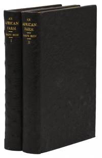
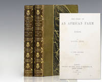
188330040London: Chapman and Hall 1883. First edition of this highspot <span class="match">of</span> Afric<span class="match">an</span> literature. Octavo original olive cloth 2 volumes. Published under <span class="match">the</span> pseudonym 'Ralph Iron'. <span class="match">The</span> entire printing <span class="match">of</span> this first edition has been estimated to be about 300 copies. and most were destined to libraries. Housed in a custom half morocco clamshell box. Rare especially in the original cloth. The Story of an African Farm published in 1883 under the pseudonym Ralph Iron was South African author Olive Schreiner's first published novel. It was an immediate success and has become recognized as one of the first feminist novels. In writing the first great South African novel Schreiner drew on childhood memories of life on the isolated African veld to fashion a powerful indictment of the rigid Boer and English social conventions of her day. It was greeted by both praise and condemnation for its feminist views on women's status and on marriage and for its unorthodox critique of dishonesty and hypocrisy in the doctrines and practices of "respectable" Christian church people. Chapman and Hall hardcover books
188330040London: Chapman and Hall 1883. First edition of this highspot of African literature. Octavo original olive cloth 2 volumes. Published under the pseudonym 'Ralph Iron'. The entire printing of this first edition has been estimated to be about 300 copies. and most were destined to libraries. Housed in a custom half morocco clamshell box. Rare especially in the original cloth. The Story of an African Farm published in 1883 under the pseudonym Ralph Iron was South African author Olive Schreiner's first published novel. It was an immediate success and has become recognized as one of the first feminist novels. In writing the first great South African novel Schreiner drew on childhood memories of life on the isolated African veld to fashion a powerful indictment of the rigid Boer and English social conventions of her day. It was greeted by both praise and condemnation for its feminist views on women's status and on marriage and for its unorthodox critique of dishonesty and hypocrisy in the doctrines and practices of "respectable" Christian church people. Chapman and Hall hardcover
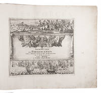
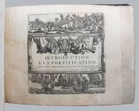
1695129558Paris: Chez l'auteur 1695. 188 engraved leaves printed on rectos only comprising the 167 plates 2 folding listed in the table of contents plus 5 plates not listed or numbered 9 plates numbered in French the pictorial title page naval and land battle scenes and 6 leaves of explanatory text for the first few plates plus a folding table of distances and a table of contents listing plates numbered 21-189 as issued; oblong 4to; early calf the spine with gilt lettered red leather title label and gilt decorated compartments between raised bands the boards rubbed with a few small surface grazes edges worn the leather lifting along fore-edge of upper board especially at bottom fore-corner small piece torn from head of spine the upper joint starting at extremities; inked ownership inscription near the bookplate of Alec Hill on the upper pastedown earlier small inked ownership inscription on upper free endpaper pencilled annotation at head of last leaf most plates neatly numbered in an early hand one plate Paris loose some damp stains occasionally large mostly to margins with a few encroaching onto plate surface several small edge chips and splits occasional slight creasing scattered light foxing and soiling; chez l'auteur Paris 1695. First edition. From the collection of Australian military historian and academic Alec Hill 1916-2008. Nicolas de Fer 1646-1720 inherited his father's cartography business which he developed into a flourishing enterprise producing town plans atlases and over 600 sheet maps and becoming one of the most prolific cartographic publishers of his era. In 1690 he was appointed official geographer to the Dauphin the heir to the French throne and when Louis XIV's grandson the Duke of Anjou acceded to the Spanish throne de Fer was proclaimed Geographer of the King of Spain as well. De Fer made maps of places throughout Europe and in North America including one in 1698 depicting beavers building dams near Niagara Falls. Introduction a la Fortification was issued in parts between 1690 and 1695 then re-issued in 1705 with the maps re-dated accordingly. Maps in this copy are dated from 1692 to 1695 with several undated. They depict fortified towns in France the Low Countries Germany Italy Spain and around the Mediterranean. The extra plates in this copy are Chartres Nouveau Canal Echelle Quebec and Batavia. The intricate folding Table Geografique enables the reader to calculate journey distances from Paris to all the principal towns in Europe. Chez l'auteur unknown
0643-23Venetia appresso Giacomo Sarzina 1623. Parte prima -seconda. 2°. 310 x 205 mm. 36 296; 176 2 728 S. Mit Initialen und 451 emeblem. Textkupferstichen je 1 ill. Kupfertit. gest. v. Gaspard Grispoldi 2 allegor. Kupfertaf. dav. 1 m. dem Portrait von Cardinal Maffeo Barberino dem späteren Papst Urban VIII ab 4. Aug. 1623. Pgmt.-Bd. d. Zt. m. handschr. Rückentit. Schwacher Wasserrand durch die erste Hälfte. Praz 336; Landwehr 295 u. 296; Graesse II 573 - Erste Ausgabe dieses großen emblematischen Werks. - Beigebunden: Ombre apparenti nel teatro d'imprese. Libro primo - secundo. Venezia Giacomo Sarzina 1629. 12 104; 2 358 66 S. Mit je 1 ill. Kupfertit. (Venetia, appresso Giacomo Sarzina 1623). unknown
1868173873Lille: Imprimerie de L. Danel 1868. Limited to 25 copies. Good overall the silk endpaper has lifted from the corner. 3/4/ black leather with 6 raised bands and gilt title second compartment. Purple silk endpapers and pastedowns. T.e.g. Title-page with large gilt-decorated emblem device above imprint. 3 preliminary leaves 7-97 2 pages mounted portrait. Preliminary states "Recueil des Discours Pronounces sur la Tombe du Baron James De Rothschild et des principaux articles de journaux publiées à l'occasion de sa mort et de ses funéreailles Ce Recuei tire vingt-cinq exemplaires est offert A Madame La Baronne James De Rothschild et a sa famille par le personnel du Chemin de fer du Nord." Includes funeral sermons and obituaries published in Le Temps Journal des debats L'Epoque and other perodicals. The photograph shows the Baron as he appeared in 1864. Worthy of restoration and exceedingly scarce. Worldcat locates 4 copies including 1 in the United States. Imprimerie de L. Danel hardcover books
a872501745. Book entirely in neat ink manuscript. Title page has VERY FINE ORIGINAL pen and ink picture of a female figure wearing a helmet with two large military maps unscrolling above her head on each side. Two cannons flank the woman on each side as well. The picture is exceptionally well-done. Both the title and the picture are so finely rendered that they appear to be printed which as far as we can tell they are not. Title page is followed by 3 page letter one blank page then 286 pages of text one blank 2 page Indice final blank. Book is stunningly illustrated with 12 foldout maps and diagrams of battleground formations. One foldout map has an armada of tiny ships very finely drawn and each with red flags facing soldiers in formation on green-outlined shoreline. All maps have at least one color some have three colors. Two maps have very attractive and elaborate rose compasses. Several show tents of soldier encampments with each tent carefully drawn. Book also has 8 foldout charts. Book was later published the first edition as far as we can tell was in 1751. The manuscript is 11-3/4 x 8 3/4 inches; 22 x 30 cm. full leather. Leather is a bit worn and rubbed with a few tiny chips and wormholes 5 raised spine bands and mounted red leather spine label with full gilt trim on spine. Cover is Good Plus; binding is very secure although inner hinges are beginning to crack. Text itself is VG plus to very near Fine. Very neat; very legible; clean no stains. A very pages have extreme tip worn off. No ownership marks except faint stamp on front end paper name is illegible. Unique as well as being an highly important historical document. Pictures sent upon request. . hardcover
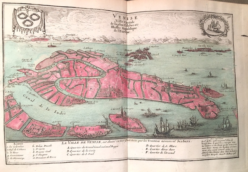
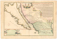
1720NL-01644<p>This exquisite and scarce map was published in Paris in 1720. The maker Nicolas de Fer was one of the most prolific and influential French cartographers of the late 17th and early 18th centuries who worked for the French King and <em>dauphin </em>crown prince.</p><p>The map depicts the most iconic cartographic myth in the European exploration of the Americas: California as a large island. This notable misconception impacted the accuracy of mapmaking for centuries and full acceptance that California was part of the continental mainland was not achieved until the mid-18th century.</p><p><strong>But why '<em>Nouvelle Caroline</em>'</strong></p><p>We can actually start at the eastern edge of the map where we see the great Mississippi River emptying into the Gulf. At first its position seems somewhat anachronistic as it follows an antiquated 17th-century notion of the Mississippi Delta located far to the west. Cartographers began rejecting this configuration after French explorer Sieur de la Salle navigated the entire lower river in 1682. Yet De Fer's choice to position the delta further west was in fact a keen political move executed in service to his patron the <em>dauphin</em>. By positioning the Mississippi so far west as to include it in this map he automatically implies a significantly enlarged French Louisiana even if it remains unseen.</p><p>The French were gradually beginning to encroach on the silver-rich regions in Upper Mexico which at that time belonged firmly to New Spain. But a great upheaval had recently taken place in Spain altering the entire political landscape of Europe. When the Spanish King Charles II died in 1700 this closed the chapter on the powerful dynasty of the Spanish Habsburgs following a long period of decline. When power subsequently transferred to Charles' nephew Phillipe of Anjou who became Philip V of Spain it passed from the Habsburgs to the Bourbons to which the French kings belonged. It was almost a personal victory for De Fer as Philip was the son of the French <em>dauphin</em> who in turn was De Fer's main patron.</p><p>A political element of cartographic land grabbing is echoed in the map's title which refers to the island as 'California or New Carolina' <em>Nouvelle Caroline</em>. This bold new proposal for an alternate name was loaded with political meaning. Following the Spanish succession some still challenged Philip's claim just as some feared an amalgamation of French and Spanish interests and power in the New World. De Fer's maps were part of the counter-propaganda touting the ambitions of his patrons as fact to exaggerate their global influence. While the term 'California' was very much tied to the envisioned island renaming the entire region <em>Nouvelle Caroline</em> New Carolina would make borders more fluid and national ownership less defined.</p><p>Beneath the title De Fer has included extensive text that constitutes an invaluable record of late 17th century missions and Indian villages in this remote part of the New World. The inclusion of this text helped cement De Fer's map as a seminal contribution to West Coast cartography. The mapmaker seems to have been well aware of the importance of this annotation as he surrounded it with fascinating vignettes depicting scenes of Native American life and the abundance of the land. He further compliments these scenes with depictions of fauna in the lower-left corner including an aardvark a sloth and a pelican or spoonbill set around the scale bar.</p><p><strong>Census and details</strong></p><p><em>La Californie ou Nouvelle Caroline </em>was published in the <em>Atlas ou recueil de cartes gegraphiques</em>. It is not only one of the most significant depictions of the California island theory but also its largest separate <em>i.e.</em> regional representation on a printed map. It is essentially an enlarged and far more focused version of his <em>Californie et Nouveau Mexique</em> published twenty years prior in <em>L'Atlas Curieux ou le Monde</em>.</p><p>De Fer's California maps drew on information provided by the Jesuit missionary Father Eusebio Kino who traveled throughout the region in the 1680s and 90s and made extensive observations including the compilation of his own maps. We know that Kino was a significant source because the map's title is taken directly from his original expedition notes and important discoveries made by Kino – such as the mouth of the St. Thomas River discovered in 1684 – have been copied directly onto De Fer's map from his original. The source is hardly a secret: De Fer uses the inset text in the upper right corner to note how his work was drawn from a map that came via the Viceroy of New Spain to the <em>Academie de Sciences in France</em>. The text also provides a history of California's exploration and subjugation up until 1695 – including the initial discovery of Baja California by Hernan Cortes – further underscoring the original author.</p><p>De Fer made several significant changes for the present map. He plots more than 300 towns and villages including many locations on the mainland and in what today is known as New Mexico and southern Arizona. The toponyms generally confirm the influence of Father Kino. Among the many places listed we find the ruins of Casa Grande identified by Kino in 1694 and appeared on this map for the first time. Important towns like San Diego Santa Fe and Mexico City are noted clearly if not prominently. We even see the first inkling of the settlements that soon would grow into Tucson and Phoenix. The spelling of many of the place names also changed on this new map just as De Fer incorporated the first Indian toponyms along the Gila River.</p><p>While the southern coastline is relatively accurately documented there are almost no place names present along the northern mainland or on the eastern side of the island reflecting how little was known about this region at the time. Along California's exterior coast we do find some toponyms in many cases related to the coves and inlets that ships would have frequented. Yet even at this early stage we are already seeing multiple toponymic references to Saint Francis San Francisco in Spanish in the island's northern part.</p><p>Turning to the toponyms of the northern interior we find <em>Gran Quivira</em> which refers to the legend of Cibola or the Seven Cities of Gold supposedly discovered by the Spanish explorer Francisco Vasquez de Coronado in 1539. While we know this terminology from many iconic early West Coast charts like Cornelis de Jode's famous map of the Northwest Pacific 1593 the myth had such pervasive power that the notion persisted well into the 18th century. In this case it has even been complimented by a second quasi-mythological eldorado reference in the toponym <em>Gran Teguaio Coqui</em>. This term originates from the <em>Benevides Memorial </em>1630 which describes it as rivaling Quivira in wealth.</p><p><strong>Context</strong></p><p>Between 1500 and 1747 confusion ensued over whether or not California previously documented in medieval folklore as a mysterious island filled with an abundance of gold was considered part of a series of various mythical islands in an unknown ocean. The "island theory" was perpetuated by Spanish explorers including Juan de la Fuca who suggested in reports published in 1592 that the large opening identifying the mouth of Mexico's Baja peninsula joined a grand bay in the northern part of the continent.</p><p>In 1622 Henry Briggs produced a map based on these reports and the travels of Samuel Purchas. Published in London Briggs' map was accompanied by an article that referred to California as a large island off the coast of <em>Newe Spaine</em>. This "island" appeared to have a rough and rocky coastline complete with smaller islands offshore. Brigg's map became the standard outline for depicting California's insularity and was copied and incorporated onto the maps of influential publishers and geographers throughout Europe.</p><p>Father Kino would eventually dispel the Island of California myth when he discovered Baja California was indeed landbound. Father Kino published this insight in Paris in 1705 some fifteen years before our map was issued quickly becoming the authoritative source for rejecting the island hypothesis. The notion stubbornly persisted despite Kino's publication of his latest observations and map. In addition to influential French cartographers like Nicolas de Fer and Philippe Buache one of the great English mapmakers of the period Herman Moll remained convinced of California's insularity. He even went so far as to claim that he had met sailors who had circumnavigated it. Soon however even the most ardent defenders would have to yield when Ferdinand VII of Spain decreed California to be a peninsula in 1747.</p><p>Cartographers:</p><p><strong>Nicolas De Fer 1646–1720</strong> was a French cartographer and geographer who also worked as an engraver and publisher. He was renowned for his massive output and his pleasant visual designs. He was the son of a Parisian cartographer and began apprenticing at an early age. By twelve however he shifted his apprenticeship to the closely associated field of engraving – a move his father no doubt encouraged as it might enhance his competitive position on the market with his son as a trained engraver.</p><p>De Fer's father died in 1673 but Nicolas did not take over the company until 1687 at which point it had been virtually run into the ground. Nevertheless Nicolas had a knack for business and soon turned things around. By 1690 he was so successful that he won employment as the official geographer to Louis <em>Le Grand Dauphin</em> of France and son of the reigning French king Louis XIV. Soon after with support from the Spanish and French courts De Fer was appointed the official geographer for King Louis XIV. In 1720 shortly before his death he was even appointed royal geographer to Philip V king of Spain.</p><p>De Fer's popularity in the Bourbon royal circles was primarily due to his appreciation of the propagandistic effects of strategic cartography. But no doubt his keen sense of aesthetics helped as well. Whatever the case his maps were hugely popular well-funded and widely distributed. He was impressively productive publishing over 600 sheets from his atelier and covering everything from town plans to world maps. Many of his maps rode the political conjunctures of the age. Hardly would a territory have been won or surrendered before De Fer's atelier was working on a map delineating the new realities.</p>
1705B2350Paris: Nicolas de Fer c. 1705. Upper fore-corner of the Toulon Grenoble St. Esprit Verceil and Veue de Verue plates all repaired professionally; otherwise a very good copy text and maps are clean and crisp. Binding: Recent ½ calf with contemporary marbled boards spine in five compartments of raised bands gilt title on two endpapers renewed. With 172 engraved plates by Nicolas de Fer and 8 in-text plates including the title. Notes: Introduction a la Fortification was a famous atlas at its timefirst published in 1690-1695. <br>The author Nicolas de Fer inherited his father’s cartography business. Being a prolific cartographer his reputation grew such that he became the official geographer of King Louis XIV of France and King Philip V of Spain. He made maps of both North America and Europe notably including maps of the War of Spanish Succession. <br> Size: Oblong folio Illustration: With 172 engraved plates by Nicolas de Fer and 8 in-text plates including the title. Lacks 9 plates St. Malo Environs de St. Malo Gravelines Nieuport Combat de Leuse Liege Camp de Weil and Civita Vecchia; but has 5 extras not called for in the plate list Aire Hesdin Menin Batavia and Quebec. Pages: P. plate index title engraved maps and text plates. Category: Book Atlas & Cartography; Book Military Nicolas de Fer hardcover
103924Paris, Société des Imprimeries Lemercier, 44 rue Vercingétorix, 1900, 2 volumes grand in-folio de 555x385 mm environ, 1 volume de texte : 1 f.blanc, faux-titre avec justificatif de tirage au dos, un frontispice, titre en 2 couleurs avec vignette représentant la tour, 6 ff. (dédicace, tables), 368 pages, 1 f. de conclusion, 1 f.blanc, + 1 volume de 53 planches doubles numérotées, +13 planches d'épreuves en taille-douce, (par suite d'une erreur dans la pagination les Planches XXVI et XXVII n'existent pas), et une carte des environs de Paris donnant les points visibles du sommet de la Tour, demi chagrin à coins noir, dos à nerfs portant titres dorés, tranches de têtes dorées, gardes marbrées. Exemplaire numéroté d'un tirage à 500 exemplaires sur vélin. Coiffe supérieure fendillée avec début de fente sur le mors (volume de texte), cuir et cartonnage décolorés par endroits avec frottements et petites épidermures, la planche 2 est reliée à l'envers, des rousseurs, léger manque de papier dans la marge inférieure sur les 5 premiers feuillets (volume de texte), la serpente du frontispice est dégradée.
1760M7182Paris: Desnos c. 1760. Very Good. Notes: These maps was originally designed by de la Hire 1640-1718 in 1705. Size : 461x461 mm 18.15x18.15 Inches Coloring: Hand Colored Reference: Tooley III:72 Category: Maps Celestial; Desnos unknown
1883140940359London: Chapman and Hall 1883. First Edition. Near Fine. First edition first printing of what is widely recognized as one of the first feminist novels. Near Fine with light rubbing to binding pages toned and with occasional instances of light spotting. Finely bound in full black ostrich skin by Sangorski and Sutcliffe mirroring the book's setting on an ostrich farm. At the time of publication the South African ostrich farming industry was rapidly developing to meet a craze for the high demand of ostrich feathers with their weight-price approaching that of gold's. The industry's rise brought about much cruelty and suffering for ostriches and the novel highlights the crossover among the contemporary leading activists of women's rights movement and the champions of animal rights. Published under a male pseudonym of Ralph Iron this was Scheiner's first novel and was met with immediate success. A complex narrative woven around themes of cruelty and restriction set against a colonial backdrop. It's notable for the main female character's handling of themes of love marriage and motherhood while subverting the traditional gender roles female sexuality and intellectual power. Published under a male pseudonym of Ralph Iron this was Scheiner's first novel and was met with immediate success. A complex narrative woven around themes of cruelty and restriction set against a colonial backdrop. It's notable for the main female character's handling of themes of love marriage and motherhood while subverting the traditional gender roles female sexuality and intellectual power. Chapman and Hall unknown books
1883140940359London: Chapman and Hall 1883. First Edition. Near Fine. First edition first printing of what is widely recognized as one of the first feminist novels. Near Fine with light rubbing to binding pages toned and with occasional instances of light spotting. Finely bound in full black ostrich skin by Sangorski and Sutcliffe mirroring the book's setting on an ostrich farm. At the time of publication the South African ostrich farming industry was rapidly developing to meet a craze for the high demand of ostrich feathers with their weight-price approaching that of gold's. The industry's rise brought about much cruelty and suffering for ostriches and the novel highlights the crossover among the contemporary leading activists of women's rights movement and the champions of animal rights.<p><br /> <br /> Published under a male pseudonym of Ralph Iron this was Scheiner's first novel and was met with immediate success. A complex narrative woven around themes of cruelty and restriction set against a colonial backdrop. It's notable for the main female character's handling of themes of love marriage and motherhood while subverting the traditional gender roles female sexuality and intellectual power. <br /> <br /> Published under a male pseudonym of Ralph Iron this was Scheiner's first novel and was met with immediate success. A complex narrative woven around themes of cruelty and restriction set against a colonial backdrop. It's notable for the main female character's handling of themes of love marriage and motherhood while subverting the traditional gender roles female sexuality and intellectual power. Chapman and Hall unknown
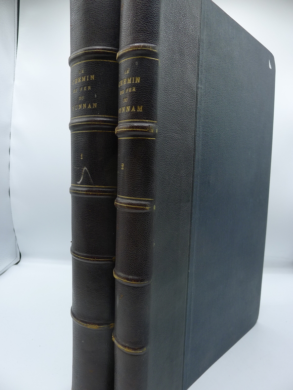
7702Paris, Imprimerie Goury, avril 1910. 2 volumes in folio. Volume I: 202 pp., reliure ancienne demi-chagrin, dos à nerfs, plats en toile chagrinée, couvertures illustrées conservées, richement illustré de 84 planches de reproductions photographiques à pleine page. Excellent état. Ouvrage toujours très rare et recherché. Riche iconographie des oeuvres d'art de la ligne et des paysages traversés. Volume II: demi-reliure basane, Atlas composé de 64 planches et cartes, la plupart à double page ou dépliantes, représentant les travaux de la construction du Chemin de Fer. Les photos ont été prises dès 1904 jusqu'à l'inauguration de la ligne en 1910. Très bon état des 2 volumes.
1883118143London: Chapman and Hall 1883. First edition of this highspot <span class="match">of</span> Afric<span class="match">an</span> literature. Octavo 2 volumes bound in three quarters contemporary morocco over marbled boards with gilt titles and tooling to the spine in six compartments within raised gilt bands top edge gilt marbled endpapers. Published under <span class="match">the</span> pseudonym 'Ralph Iron' t<span class="match">he</span> entire printing <span class="match">of</span> this first edition has been estimated to be about 300 copies and most were destined to libraries. From the library of British-born South African financier mining magnate and politician Sir Lionel Phillips with his bookplates to the pastedowns. Lionel and Florence Phillips left South Africa a major legacy through their art collections. Florence campaigned for the founding of the Johannesburg Art Gallery and arranged its first collections including her lace collection while Lionel donated seven oils and a Rodin sculpture. Rare and with desirable provenance. The Story of an African Farm published in 1883 under the pseudonym Ralph Iron was South African author Olive Schreiner's first published novel. It was an immediate success and has become recognized as one of the first feminist novels. In writing the first great South African novel Schreiner drew on childhood memories of life on the isolated African veld to fashion a powerful indictment of the rigid Boer and English social conventions of her day. It was greeted by both praise and condemnation for its feminist views on women's status and on marriage and for its unorthodox critique of dishonesty and hypocrisy in the doctrines and practices of "respectable" Christian church people. Chapman and Hall hardcover books
1883118143London: Chapman and Hall 1883. First edition of this highspot of African literature. Octavo 2 volumes bound in three quarters contemporary morocco over marbled boards with gilt titles and tooling to the spine in six compartments within raised gilt bands top edge gilt marbled endpapers. Published under the pseudonym 'Ralph Iron' the entire printing of this first edition has been estimated to be about 300 copies and most were destined to libraries. From the library of British-born South African financier mining magnate and politician Sir Lionel Phillips with his bookplates to the pastedowns. Lionel and Florence Phillips left South Africa a major legacy through their art collections. Florence campaigned for the founding of the Johannesburg Art Gallery and arranged its first collections including her lace collection while Lionel donated seven oils and a Rodin sculpture. Rare and with desirable provenance. The Story of an African Farm published in 1883 under the pseudonym Ralph Iron was South African author Olive Schreiner's first published novel. It was an immediate success and has become recognized as one of the first feminist novels. In writing the first great South African novel Schreiner drew on childhood memories of life on the isolated African veld to fashion a powerful indictment of the rigid Boer and English social conventions of her day. It was greeted by both praise and condemnation for its feminist views on women's status and on marriage and for its unorthodox critique of dishonesty and hypocrisy in the doctrines and practices of "respectable" Christian church people. Chapman and Hall hardcover
11281Paris, Imprimerie Goury, avril 1910. 2 volumes in folio. Volume I: 202 pp., reliure moderne plein cuir, couvertures illustrées conservées, richement illustré de 84 planches de reproductions photographiques à pleine page. Volume II: reliure moderne plein cuir, Atlas composé de 64 planches et cartes, la plupart à double page ou dépliantes, représentant les travaux de la construction du Chemin de Fer. Les photos ont été prises dès 1904 jusqu'à l'inauguration de la ligne en 1910. Ouvrages en très bon état.
19106112Serrurerie et cuivrerie artistiques. Spécialité pour Bâtiment. Aperçu des principaux modèles. 2 Teile in 1 Band. Mit 266 doppelblattgr. lithogr. Tafeln auf leicht rötlichem Papier, gedruckt von Edm. Genet, Paris. Paris, [ca. 1900-1910]. Folio (44,0 x 33,0 cm). Titel, 2 Bl. Inhalt u. Zwischentitel. Blindgepräger Orig.-Halblederband mit Rückenvergoldung.
1705R300113009A PARIS CHEZ L'AUTEUR DANS L'ISLE DU PALAIS A LA SPHERE ROYALE. 1705. In-4. Cartonné. Etat d'usage, Plats abîmés, Dos satisfaisant, Intérieur frais. Atlas comportant 18 cartes en noir et blanc et 18 pages de texte (textes sur deux colonnes) - DESCRIPTIONS DES CARTES : Correspondance du globe terrestre a la sphère céleste situation des habitans du monde des cercles de longitude et de latitude et des diverses positions de la sphère - carte générale du globe terrestre et aquatiques ou mappemonde en deux plans hémisphere - L'Europe dressée sur diverse relations - L'Asie dressée sur divers relations - L'Afrique dressez sur les dernières relations - L'Amérique Méridionale - L'Amérique septentrionale et les terres polaires artiques - La France avec des acquisitions jusqu'a l'année 1705 - Les environs de Paris - Les XVII Provinces des Païs Bas divisées en Provinces Unies en Païs Bas catholiq et en Païs Bas François - Les Isles Britanniques ou sont les Royaumes d'Angleterre d'Escosse et d'Irlande avec les costes septentrionales de France et celles des Païs Bas - Suede Norvegue et Dannemarck - Allemagne divisée en dix cercles dressées sur les derniers memoires - Les Estats de la couronne de Pologne - Estats du Grand Duc de Moscovie suivant les derniere relations - Hongrie ou partie sepentrionale de la Turquie en Europe - L'Espagne divisée en Galice Asturies Biscaye Navarre Leon Vielle et Nouvelle Castille Arragon Andalousie Mursi Valence et Catalogne avec les Isles Majorque Minorque et Yvica - L'Italie divisée en ses principaux Estats - plats cartonnés - coins frottés - annotations sur la page de garde - 10 photos disponibles.. . . A l'italienne. Classification Dewey : 840.05-XVIII ème siècle