MareMagnum

11 843 résultats
Milano, 2020; br., pp. 104, ill. col., cm 24x28. (Musei e Luoghi Artistici).
Fotografie di Massimo Listri. Testi di Raniero Gnoli, Carlo Gasparri, Salvatore Settis e Alvar Gonzalez-Palacios. Milano, 2021; ril., pp. 368, ill. col., cm 29x38. (Progetti speciali Rizzoli).
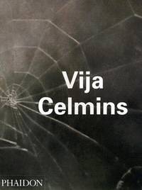
2004Alibris.0017380London England: Phaidon Press. 2004. Trade paperback. Very good. Trade paperback US. 160 p. Contains: Illustrations. Phaidon Contemporary Artist. Audience: General/trade. . Phaidon Press paperback
2004Q-0714842648Phaidon Press 2004-12-01. Paperback. New. In shrink wrap. Looks like an interesting title! Phaidon Press paperback
2004203716London: Phaidon 2004. Softcover. VG: Exlibary book. Sticker at the base of the spine. Stamp on the first page. Stamp on the last page. A softcover book with French flaps. The title is in white down a gray spine. Pages: 7 8-160. Profusely illustrated with a majority black-and-white images. Phaidon paperback
2004208584London: Phaidon 2004. Softcover. VG. Clean and unmarked. Close to new. Quarto. Softcover with French flaps. The title is in white down a gray spine. Pages: 7 8-160. Profusely illustrated with a majority black-and-white images. Phaidon paperback
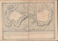
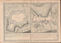
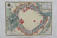
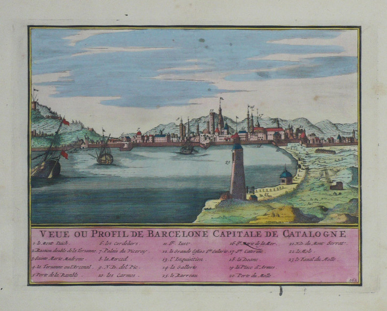
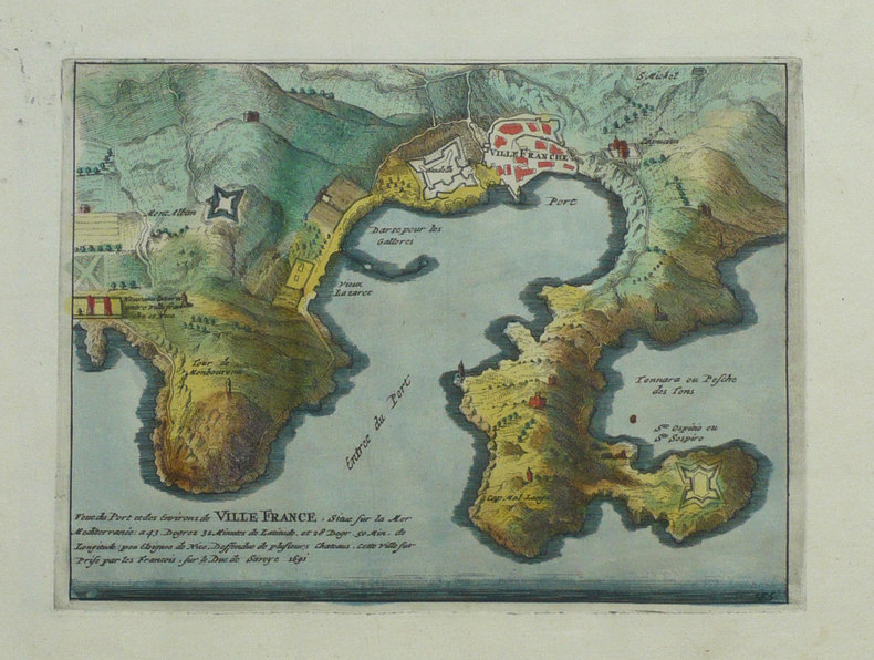
51-6473Paris: chez l'auteur dans l'Isle du Palais sur le quay de l'orloge a la Sphére Royale avec privilége du Roy 1705-1717. Engraved map. 27.3 x 38cm. Contemporary laid paper uniformly time aged.Elvas is a fortified hilltop town on the Spanish border east of Lisbon. The Portuguese too the city fromthe Moors in 1226 and it was captured by Spain in 1580. The fortifications date mostly from the 17th century and there is a 16th-century aqueduct.Evora is the capital of the province of Alentejo east of Lisbon It was captured by the Romans in 80 BC and has a Roman aqueduct and temple of Diana the goddess of hunting. There is also a 13th-century Gothic cathedral. From the 14th to the 16th centuries Evora was the residence of the Kings of Portugal.This map was published during the War of the Spanish Succession a conflict in which Portugal and Lisbon featured prominent hence the depiction of the fortifications of the city.Published in "L'atlas curieux ou le monde reÌpreseÌnteÌ dans des cartes geÌneÌrales et particulieres du ciel et de la terre : diviseÌ tant en ses quatre principales parties que par eÌtats et provinces et orneÌ par des plans et descriptions des villes capitales et principales et des plus superbes edifices qui les embelissent comme sont les eglises les palais les maisons de plaisance les iardins les fontaines &c. ". OCLC Number / Unique Identifier:79022119.LThe Atlas Curieux is geographic encyclopedia of images and maps of France with detailed views of the grand waterworks at Marly views of the great palaces and chateaux views and plans of the Paris Observatory and samples of military architecture. Issued in six annual parts from 1700-1705 the maps are based on the new observations of the Académie des Sciences and drawn up with the assistance of Philipe de La Hire.Library of Congress:The French cartographer and engraver Nicolas de Fer was a master at creating maps that were works of art. The maps that he published were printed during the Baroque period when the decorative arts were characterized by ornate detail. De Fer’s detailed maps and atlases were valued more for their decorative content than their geographical accuracy.Nicolas de Fer was born in 1646. His father Antoine de Fer owned a mapmaking firm. At the age of twelve Nicolas was apprenticed to a Parisian engraver named Louis Spirinx. The family business was starting to decline when his father died in 1673. Nicolas de Fer’s mother Genevieve took over the business after the death of her husband. In 1687 the business was passed on to Nicolas and the profits increased after he took over the firm. Nicolas de Fer was a prolific cartographer who produced atlases and hundreds of single maps. He eventually became the official geographer to King Louis XIV of France and King Philip V of Spain.One of de Fer’s major works is an atlas titled L’atlas curieux The curious atlas. Paris: chez l'auteur dans l'Isle du Palais sur le quay de l'orloge a la Sphére Royale avec privilége du Roy, 1705-1717 unknown
51-6475Paris: chez l'auteur dans l'Isle du Palais sur le quay de l'orloge a la Sphére Royale avec privilége du Roy 1705-1717. Engraved map. 27.3 x 38cm. Contemporary laid paper uniformly time aged.Elvas is a fortified hilltop town on the Spanish border east of Lisbon. The Portuguese too the city fromthe Moors in 1226 and it was captured by Spain in 1580. The fortifications date mostly from the 17th century and there is a 16th-century aqueduct.Published in "L'atlas curieux ou le monde reÌpreseÌnteÌ dans des cartes geÌneÌrales et particulieres du ciel et de la terre : diviseÌ tant en ses quatre principales parties que par eÌtats et provinces et orneÌ par des plans et descriptions des villes capitales et principales et des plus superbes edifices qui les embelissent comme sont les eglises les palais les maisons de plaisance les iardins les fontaines &c. ". OCLC Number / Unique Identifier:79022119.LThe Atlas Curieux is geographic encyclopedia of images and maps of France with detailed views of the grand waterworks at Marly views of the great palaces and chateaux views and plans of the Paris Observatory and samples of military architecture. Issued in six annual parts from 1700-1705 the maps are based on the new observations of the Académie des Sciences and drawn up with the assistance of Philipe de La Hire.Library of Congress:The French cartographer and engraver Nicolas de Fer was a master at creating maps that were works of art. The maps that he published were printed during the Baroque period when the decorative arts were characterized by ornate detail. De Fer’s detailed maps and atlases were valued more for their decorative content than their geographical accuracy.Nicolas de Fer was born in 1646. His father Antoine de Fer owned a mapmaking firm. At the age of twelve Nicolas was apprenticed to a Parisian engraver named Louis Spirinx. The family business was starting to decline when his father died in 1673. Nicolas de Fer’s mother Genevieve took over the business after the death of her husband. In 1687 the business was passed on to Nicolas and the profits increased after he took over the firm. Nicolas de Fer was a prolific cartographer who produced atlases and hundreds of single maps. He eventually became the official geographer to King Louis XIV of France and King Philip V of Spain.One of de Fer’s major works is an atlas titled L’atlas curieux The curious atlas. Paris: chez l'auteur dans l'Isle du Palais sur le quay de l'orloge a la Sphére Royale avec privilége du Roy, 1705-1717 unknown
51-6474Paris: chez l'auteur dans l'Isle du Palais sur le quay de l'orloge a la Sphére Royale avec privilége du Roy 1705-1717. Engraved map. 27.3 x 38cm. Contemporary laid paper uniformly time aged.Elvas is a fortified hilltop town on the Spanish border east of Lisbon. The Portuguese too the city fromthe Moors in 1226 and it was captured by Spain in 1580. The fortifications date mostly from the 17th century and there is a 16th-century aqueduct.Published in "L'atlas curieux ou le monde reÌpreseÌnteÌ dans des cartes geÌneÌrales et particulieres du ciel et de la terre : diviseÌ tant en ses quatre principales parties que par eÌtats et provinces et orneÌ par des plans et descriptions des villes capitales et principales et des plus superbes edifices qui les embelissent comme sont les eglises les palais les maisons de plaisance les iardins les fontaines &c. ". OCLC Number / Unique Identifier:79022119.LThe Atlas Curieux is geographic encyclopedia of images and maps of France with detailed views of the grand waterworks at Marly views of the great palaces and chateaux views and plans of the Paris Observatory and samples of military architecture. Issued in six annual parts from 1700-1705 the maps are based on the new observations of the Académie des Sciences and drawn up with the assistance of Philipe de La Hire.Library of Congress:The French cartographer and engraver Nicolas de Fer was a master at creating maps that were works of art. The maps that he published were printed during the Baroque period when the decorative arts were characterized by ornate detail. De Fer’s detailed maps and atlases were valued more for their decorative content than their geographical accuracy.Nicolas de Fer was born in 1646. His father Antoine de Fer owned a mapmaking firm. At the age of twelve Nicolas was apprenticed to a Parisian engraver named Louis Spirinx. The family business was starting to decline when his father died in 1673. Nicolas de Fer’s mother Genevieve took over the business after the death of her husband. In 1687 the business was passed on to Nicolas and the profits increased after he took over the firm. Nicolas de Fer was a prolific cartographer who produced atlases and hundreds of single maps. He eventually became the official geographer to King Louis XIV of France and King Philip V of Spain.One of de Fer’s major works is an atlas titled L’atlas curieux The curious atlas. Paris: chez l'auteur dans l'Isle du Palais sur le quay de l'orloge a la Sphére Royale avec privilége du Roy, 1705-1717 unknown
1705M4699Paris 1705. Excellent. Size : 245x340 mm 9.625x13.375 Inches Coloring: Hand Colored Category: Maps City Maps; Maps Europe Austria unknown
20192-0464287111Blurb 2019. Hardcover. New. 480 pages. Spanish language. 8.23x5.32x1.50 inches. Blurb hardcover
In-8° gr., pp. 750 con più di 490 figure intercalate n.t. e diverse tabelle e grafici n.t. Bross. edit. tracce del tempo e d'uso, con numerose segnature sottolineature e note a matita all'interno. Tracce di rinforzi adesivi sui piatti e dorso.
Milano, 2013; ril., pp. 552, ill., cm 29x42. (Viaggio nelle Pubblicità Storiche. 1).
A cura di G. Montevecchi. Ravenna, 2003; br., pp. 194, ill. b/n e col., cm 22x24. (Viaggio nei siti archeologici della provincia di Ravenna. 35. Collana diretta da Giovanna Montevecchi).
186446907ABDarmstadt, G.G. Lange 1864. 8.0 x 10.4 cm. Gerahmt, Holzleiste (25 x 30 cm).
2006RO20197119ALAN SUTTON. 2006. In-8. Broché. Bon état, Couv. convenable, Dos satisfaisant, Intérieur frais. 128 pages - nombreuses photos en noir et blanc et en couleurs dans et hors texte - frontispice en noir et blanc.. . . . Classification Dewey : 625-Chemins de fer, routes, autoroutes
77714Paris - Londres - Zurich, A. Ghio - C. Smith & Son - Orell Füssli & Cie. sans date, vers 1889, 180x120mm, 40pages, broché. Bel exemplaire.
77715Zurich, Orell Füssli & Cie. sans date, vers 1890, 180x120mm, 47pages, broché. Inscriptions manuscrites sur le haut de la couverture supérieure. Bon état.
1702LBW-1304Amsterdam Pierre Mortier 1702 210 x 270 mm.
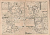
170578538Paris: 1705. Nicolas de Fer's excellent plan of the Nieuburg House where the treaty of Ryswick in the Netherlands was signed in 1697 and not 1705 as stated in the print. From the "Atlas Curieux ou Le Monde". Copper engraving. Hand colouring. Size: 275 x 400 mm Good condition. unknown
1702LBW-1359Amsterdam Pierre Mortier 1702 154 x 205 mm.
2n1788De Fer Paris 1705. Maße: 19 cm x 122 cm. - Nicolas de Fer war einer der führenden französischen Kartographen und Kartenverleger - unknown
18295673Aus dem Schwedischen übersetzt von J. W. Pfaff. Mit 11 gefalt. gest. Tafeln von C. A. Broling. Nürnberg, J. L. Schrag, 1829. 4to. (23,7 x 20,3 cm). XVIII S., 1 Bl., 268 S., 2 Bl. (Verbesserungen, Anzeigen). Marmorierter Halblederband d. Zt. mit Rückenvergoldung. [2 Warenabbildungen]
17853860Aus dem Schwedischen übersetzt von Johann Gottlieb Georgi. 2 Bände. Mit 2 gest. Tafeln. Berlin, Haude & Spener, 1785. 8vo. (20,2 x 11,2 cm). 1: XVI, 512 S. 2: 4 Bll., 456 S., 19 Bll. Register. Gesprenkelte Kalblederbände d. Zt. mit etwas Rückenvergoldung u. grünem Lederrückenschild.