[MATERIA MEDICA] CampanaBiblio.com
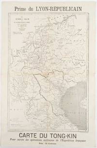
[MESOPOTAMIAN CAMPAIGN].Biblio.com
Critical study of the campaign in Mesopotamia up to April 1917. Part II - Maps.
1925ABC_47726Calcutta: Government of India Press 1925. Original tan cloth map-case with original printed label to cover. 25 of 26 folding maps sketches etc. as always lacking the "Explanation of the Method of giving Map Co-ordinates adopted in Chapters XIII and XX". An excellent set of maps documenting the battlefields of the Mesopotamian Campaign of WWI: "In the Autumn of 1923 a tour of the Mesopotamian battlefields was undertaken by the instructors and students of the Staff College Quetta and the course of the campaign and the principal operations were studied on the spot" Introduction Part I not present. Printed at the Survey of India Offices Dehradun the maps cover the major sites of the conflict. Maps of note include a simplified version of the sought-after "Lower Mesopotamia" War Office map an elegant map of the Battle of Ctesiphon and a detailed map of Sheikh Saad and Kut-Al-Amara which includes an interesting note on the burgeoning cartography of the area: "The first map with any pretensions to accuracy was not produced till the summer of 1916". Designated "For Official Use Only" this study is uncommon. There are no print-run details given in the text volume but the markings on the maps suggest that there may have been 1000 copies produced. LibraryHub locates three copies at King's College London the London Library and the British Library. WorldCat adds seven more with three in North America three in Australia and one in South Africa.Without the text volume Part I and lacking 1 maps as usual. Some spotting and closed tears to several of the smaller maps printed on thin paper larger folding maps in very good condition. Map-case rubbed with some wear and splits to extremities. Ownership inscription of R. T. Holland to front cover. Government of India Press, hardcover
Antiquariaat FORUM BV · Pays-Bas3 500,00 €