4 134 résultats
201316331Paris, Olivier Orban, 1990 ; in-8, 304 pp., br.
200811210Paris, Olivier Orban, 1990 ; in-8, 304 pp., broché, couverture illustr.
200810330Paris, Olivier orban, 1991 ; in-8, 303 pp., broché, couverture illustr.
Small 8vo. 2 vols. in one. (16), 260, (4) pp. (2), 318 pp. Contemporary half calf over marbled boards with giltstamped red spine label. Extremely rare second Spanish edition of Guellette's "Les Mille et un Quarts-d’heure, contes tartares" (1715), or "The Thousand and One Quarter-Hours": a series of orientalist tales, of supposedly Tartarian origin, in imitation of Galland's newly-published and wildly popular "Les Mille et Un Nuits", even including additional Sindbad material. The work is sometimes confused with the "Nights" proper: as recently as 2016, Axel Gasquet writes in his study "El llamado de oriente", published by the University of Buenos Aires: "En 1789 un fraile espanol, Miguel de Sequeiros, entrega a la imprenta madrilena un volumen titulado 'Los Mil y un Quartos de Hora: Cuentos Tártaros', que fue la primera traducción expurgada castellana" (i.e., of Galland's "Thousand and One Nights"). In fact, Sequeiros's translation of Gueullette's quite original effort had first appeared in 1742. The two volumes are rarely encountered together; OCLC lists a single complete copy (in the Pontificia Universidad Católica del Perú). - Light browning and staining. Handwritten ownerships of Louisa Lee (dated Malaga, 1820), another "Miss Lee" (Florence, 1823), and Adriana Malzac. Palau 168945. OCLC 905226322.
8vo. pp. 137-171 (entire volume: x, 137-262, (6) pp., with 28 photographic illustrations, numerous sketch maps in the text, and two folding maps, one in colour, loosely inserted). Original printed blue wrappers. The famous British explorer's extensive account of his expedition in the interior of Oman; much of the territory crossed now is part of the United Arab Emirates. Thesiger (1910-2003) set out from Abu Dhabi in 1948; the large and detailed colour map shows his journeys from 1945 to 1950. - Thesiger later expanded on the subject to produce his classic travelogue, "Arabian Sands" (1959). Thesiger's highly regarded photographs depict the desert of the Empty Quarter, a settlement at Liwa, sand vegetation after heavy rain, a falconer mounted on a camel, a peregrine falcon with a caught hare, peregrine falcons on the blocks, Sheikh Wahiba of Yahahif and a young Wahiba girl, a thoroughbred Batina camel, the Farai well in Wahib country, portraits of Musallim bin al-Kamam and Salim bin Kabina, and a view of Jabal Kaur from the wadi Saifam. The paper was read in the presence of the Second Secretary at the Saudi Arabian Embassy, H.E. Abdul Rahman Halassie. Not in Macro.
Folio (210 x 335 mm). Publisher's original blue printed boards. First edition. A separate annual "Administration Report" on the Gulf region which the British Political Residents submitted to the Indian Viceroy and Governor. The bland official title belies the true value of the series, which has been called "a mine of information on the development of the modern Gulf" (Cambridge Archive Editions). Regularly the reports contain political details of the local sheikhdoms as well as trade information. - The present issue offers a detailed introduction by the resident British Consul and Political Agent C. A. Kemball, commenting on the Sultan, his tours, customs and taxes, slave trade, and an outbreak of disease ("small-pox of a severe type appeared at Shargah in the first week of April, causing, it was reported, about 500 deaths"). Kemball further reports on a "Pearl Dispute" in which "the Sultan was interested, connected with the discovery and sale of a pearl of extraordinary value", which has "at last been amicably settled by a committee consisting of certain of the Trucial Chiefs". The Consul "visited the Arab Coast in December and met the Chiefs of Shargah [Sheikh Saqr bin Khalid Al Qasimi] and Ajman [Sheikh Abdulaziz bin Humaid Al Nuaimi]. The Chief of Abu Dhabi [Sheikh Zayed bin Khalifa Al Nahyan] was away in the interior, but I saw his son [Khalifa bin Zayed bin Khalifa Al Nahyan] and other principal men [...]". He also discusses the dispute between the Chiefs of Abu Dhabi, Sharjah and Ajman over the colonisation of Al Zorah by the Al-Suwaidi, the July 1900 coup by which Sheikh Abdulaziz bin Humaid Al Nuaimi seized power in Ajman, and the newly established joint rulership of Sharjah and Ras Al Khaimah by Sheikh Saqr bin Khalid Al Qasimi, which would last until 1914. - The "Administration Report on the Persian Gulf" was published under various titles annually between 1875 and 1957. Original specimens are almost unobtainable in the trade. - Binding rebacked with tape. Provenance: removed from the London Library, with their printed label on the upper cover and their stamps (in blind and printed) on title-page and final leaf, accompanied by cancel stamps. Macro, p. xii (s.v. "RAPA": Report on the Administration of the Persian Gulf Political Residency and Muscat Political Agency). OCLC 224558510. ZDB-ID 768652-3. Cf. the 1989 Cambridge Archive Editions reprint.
Folio (212 x 333 mm). Publisher's original blue printed boards, black cloth spine hand-lettered. Appendices to the annual "Administration Report" on the Gulf region which the British Political Residents submitted to the Indian Viceroy and Governor. The bland official title belies the true value of the series, which has been called "a mine of information on the development of the modern Gulf" (Cambridge Archive Editions). Regularly the reports contain political details of the local sheikhdoms as well as trade information. - The present appendix volume contains the meteorological tables for the year 1896/97 as well as, crucially, the year's trade reports for the entire Gulf region. The issue notes widespread lower trade revenues, which it diagnoses as due to an Indian plague and subsequent quarantines of port cities, as well as ongoing political unrest in Qajar Iran following the assassination of the Shah, Naser al-Din Shah Qajar, the previous year. The volume provides carefully detailed charts of imports and exports for Bushire, Lingah, Bunder Abbas, Bahrain, the Arab Coast of the Gulf, and Shiraz. Though most exports dropped, the value of Bahrain's in fact had gone up since the previous year, with its most valuable exports being coffee, rice, and printed cottons to Turkey and the especially valuable export of pearls to India. On the Arabian Gulf Coast, principal exports were, again, pearls, though these were largely bound to "Persian ports". Those on the Arab Coast also benefitted from the mother o' pearl shell trade, one of the least impacted by the upheavals of India and Qajar Iran. - The "Administration Report on the Persian Gulf" was published under various titles annually between 1875 and 1957. Original specimens are almost unobtainable in the trade. - Provenance: removed from the London Library, with their printed label on the upper cover and their stamps (in blind and printed) on title-page and final leaf, accompanied by cancel stamps. Macro, p. xii (s.v. "RAPA": Report on the Administration of the Persian Gulf Political Residency and Muscat Political Agency). OCLC 224558510. ZDB-ID 768652-3. Cf. the 1989 Cambridge Archive Editions reprint.
Oblong 4to. Pop-up book containing 8 pop-ups with moveable parts. (8) pp. Text in English and Arabic. Printed boards. Colourful pop-up book for travelling children, published in the 1970s by Gulf Air's Public Relations department in Bahrain and illustrated by Gloria Nixon. - One moveable part missing, some creasing, otherwise in good condition.
Large coloured map (136.5 x 90.5 cm). Scale 1:945,200. Relief shown by hachures and spot heights. Detailed nautical chart of the Gulf of Aden, showing the waters between the Horn of Africa and the South-western coast of Saudi Arabia. "From British, French, and Italian surveys to 1940 with additions and corrections to 1951", this 15th edition issued in 1955 and revised 21 May 1962. With inset maps of Bandar Risut and Qishn Bay (stamped "Cancelled"). Signs of contemporary use, with a 1964 stamp, several pencil markings, duststains and waterstains. Cf. OCLC 31674450 (17th ed., 1978). Not in Al Ankary; Al-Qasimi.
685 x 510 mm. Scale 1:29,100. Nautical chart (3752) of the Gulf of Suez. Engraved chart, including tidal information, compass roses, soundings, seabed notations, currents, sandbanks, shoals, inland elevations. This edition first published in 1909, revised in 1920, with stamp "examined & corrected 1926". Signs of contemporary use with markings in red ink. A few edge flaws.
192549705Pittsburgh PA & Port Arthur TX: Gulf Refining Co. ca. 1925. Folio. 11.5 x 14.25 in. 5 large oversize folding leaves of typed descriptions measurements specifications; mounted 7 linen-backed photo leaves 2 folding -- w/ 39 images printed on 34 silver gelatin photos. Original split-pin post-binder blue silk red cloth corners brass split pins minor edgewear rubbing minor fraying to corners first typed leaf w/ creasing minor closed tears still a VG exemplar from the library of John W. Jackson former Marketing & Sales executive with Gulf Oil Corporation Tulsa OK. This spectacular packaging catalogue for Gulf Oil Company petroleum products in the 1920s provides an incomparable photographic reference for all of the available products their dimensions sizes specific directions about tin lithograph colours as well as the cardboard and wooden shipping crates. Gulf Oil Corporation was initially organized in May 1901 by J.M. Guffy Andrew W. Mellon and others. By 1907 they had built a 400-mile pipeline from Port Arthur to the Glenn Pool Field in Oklahoma and started refining Oklahoma crude by 1907. By the 1920s this integrated Oil Company had built service stations across the country sold Good Gulf Gasoline and actively promoted automobile travel with Gulf Maps marketing promotions and more. This catalogue begins with photos of 1 5 10 and 25 lb. tins of Gulf Supreme Grease Transmission Grease Red Top Axle Grease Gulf Petrol-atum Gulf High Pressure Grease and Gulf Lubricant with all of the product tins carefully sized by stack showing their side graphics sizes lids and lid configurations. The oil cans include Tractor Oil Auto Oil Harvester Oil Gulf Motorcycle Oil small illustration of 1920s era motorcycle with Gulf Logo and even the blank tin soldered cans of assorted sizes. Of particular interest are the images of all the specialty products Gulf Oil was marketing during the Flapper Era including Venom pesticide & bug killer in glass bottles with screw-top tin lids & corks; Gulf Gas-o-Clenz cans in 1/2 pint 1 pint 1 quart and 1 gallon sizes; Gulf Gleam Cans Gulf Jelly Clens tubes Gulf Grease tubes and more. The last group of photos show all of the varieties of Gulf Venom Jelly-Clenz Gulf Pressure Grease Gulf Gleam cardboard and wooden packaging complete with printed labels lithograph labels Venom hand-sprayers and packaging and crates in assorted sizes and amounts. These types of photographic sales catalogues for the Petroleum industry are quite scarce and often unique items. Gulf Refining Co., hardcover
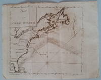
17893818<p>Appearing in the March 1789 issue of the American Museum magazine this engraving is the second American version of Franklin's famous chart of the Gulf Stream printed in America. Both American versions were preceded by English and French printings. The <strong>Chart of the Gulf Stream</strong> accompanies Franklin's "Remarks upon the navigation from Newfoundland to New York." p. 213 in the magazine. Franklin prepared the chart in 1768 while serving in London as a deputy postmaster general for mail service to and from the American colonies. It was Franklin's cousin Timothy Folger of Nantucket who provided him with a practical seafarer's knowledge of the Gulf Stream and its importance in trans-Atlantic crossings.</p><p>The previous American publication of the chart was in 1786 in <em>The Transactions of the American Philosophical Society</em>. This updated version provides a more accurate depiction of the North American coast. State boundary lines are partially indicated. One curious boundary delineation in the chart has a portion of the District of Maine extending over the northern boundaries of New Hampshire and part of Vermont.</p><p><strong>References:</strong> Wheat & Brun <em>Maps & Charts Published in America before 1800</em>: 723.</p><p><strong>Condition:</strong> Folded as issued with misfolding along one fold line. Light to occasionally moderate soiling. Edge roughness primarily at upper left edge.</p><p>ICN 7794.1</p> Mathew Carey
Folio. 2 vols. 503, (1) pp. 460 pp. Dark brown calf bindings with fore-edge flap; oxydized giltstamped cover decorations); wants upper cover of vol. 1.
12 maps, various sizes and scales. Rare collection of maps relating to the proposed construction of a railway between Haifa and Baghdad. In the 1920s the British contemplated building such a railway that would have connected the Mediterranean with the capital of Iraq, ostensibly to shore up their imperial rule, support the British-backed Arab government of Iraq, and secure the oil pipeline already running from the Mosul oilfields to Haifa. They were also aware that developments of aerial warfare made the Suez Canal susceptible to aerial attacks in wartime, and alternative military routes across the Middle East to India were sought. However, a series of economic difficulties trumped political and military expediency, and with the outbreak of the Second World War, the dream of a trans-Middle Eastern rail service evaporated. - The present collection includes: 1) Baghdad (Valleys of the Euphrates and Tigris from Kirkuk (N-S) and Ramadi to Kermanshah (E-W), Baghdad at the centre. Scale 1:1,000,000. 2) Untitled French map, showing Baghdad to Deir-ez-Zor (E-W) and Mosul to Baghdad (N-S). Bureau Topographique des Troupes françaises du Levant, May 1933. Colour-printed. 850 x 630 mm. 3) Untitled map showing the area between Abu Kemal on the Euphrates and Tikrit on the Tigris. 4) Jaffa-Nablous. Jaffa-Amman (E-W). Reproduction of a "carte de reconnaissance" by E. L. Ottoman. Scale 1:200,000. Paris, Service Geographique de l'Armee, 1930. Colour-printed. 690 x 540 mm. 5) Four air photo maps showing Holt's Zerka Valley Alignment (thus titled by hand, referring to Major A. L. Holt, R.E.). Haifa-Baghdad rly. survey. Trans-Jordan. Surveyed at War Office from photographs by the R.A.F. ground control under the direction of Major R. L. Brown, R. E. Showing a section of the Jordan river and the country east to Jerash. Colour-printed, with the proposed rail route marked in crayon with annotations. Scale 1:24,000. Each map 940 x 730 mm. 6) Four manuscript maps maps, coloured: a) Haifa-Baghdad Railway. Geological Map of Zerka Route, by G. S. Blake, B.Sc., F.G.S. 1934. 1350 x 530 mm. b) Haifa-Baghdad Railway, Geological Plan and Section, by G. S. Blake. 1380 x 880 mm. c) Map of Zerka Route. Haifa-Baghdad Railway. 1500 x 750 mm. d) Geological Section from Damascus to Rutba to show westerly inclination of strata. 1200 x 340 mm. Geological section along proposed route of Haifa Baghdad railway from the Jordan to the Euphrates. - Some edge tears with occasional loss to paper but not to the map. A rare survival.
Folio (242 x 344 mm). 14 tables on double-page-spreads (15 ff.). Original printed wrappers. Rare report on the regulation and organisation of the Hajj produced under the auspices of the Administration Sanitaire de l'Empire Ottoman for the Hejaz region. The detailed statistics on the numbers and origins of the pilgrims, their ships and ports of embarkation, their travel routes, etc., were published annually between 1896 and 1914. - A light dampstain to the inner margin of lower wrapper, backstrip starting to split. OCLC 73048636. ZDB-ID 2444067-X.
8vo (144 x 202 mm). Ottoman manuscript on paper. 122 pp., 13 lines, single column. Black ink with occasional red and blue. With a double-page illustration. Contemporary full brown calf with fore-edge flap and blindstamped ornaments to both covers. An Ottoman Turkish manuscript on the Hajj, describing the rituals of the pilgrimage and the traditional travel route from Turkey through the Levant to Medina and Mekkah. The book includes a rough, annotated drawing of the Prophet’s Mosque and a drawing of the Grand Mosque. - Some edge flaws and tears; occasional waterstains, mainly confined to the wide margins. Early 19th century waqf stamp to the flyleaf. A well-preserved survival.
8vo (220 x 150 mm). 210 volumes in 212, comprising a complete run of the first series (vols. 1-100) and second series, part 1 (vols. 1-110). Illustrated. Original green and blue cloth, spines gilt, with giltstamped motif of the ship "Victoria" on the upper covers. A primary reference work on the history of travel and exploration, including the principal accounts of the great voyages to the Middle East. This is a complete run of the first series and a large part of the second series (with its first part complete), dating from 1847 to 1956, of the publications of the Hakluyt Society. Early volumes of interest to the student of the exploration of the Muslim world, but also of the world's exploration by Muslims, include the travels of Abd-er-Razzak (India in the 15th Century, vol. 22, 1857), the travels of Ludovico de Varthema in Egypt, Syria, Arabia Deserta and Arabia Felix (vol. 32, 1863), and the History of the Imâms and Seyyids of 'Omân by Salîl-ibn-Razîk (vol. 44, 1871, providing the first indigenous account of the history of Oman in English), as well as the travels to Tana and Persia, by Josafa Barbaro and Ambrogio Contarini (with a Narrative of Italian Travels in Persia in the 15th and 16th Centuries, vols. 49a and 49b, 1873). The "Commentarios" of Afonso de Albuquerque, the first European to enter the Arabian Gulf, are present in a careful edition from 1875ff. (vols. 53, 55, 62, and 69), while the early 15th century narrative of the "Bondage and Travels of Johann Schiltberger, a Native of Bavaria, in Europe, Asia, and Africa" is the first account by a western Christian to state the true burial place of Muhammad, at Medina. Volumes 72 and 73 (1886) contain accounts of early voyages and travels to Persia, while vols. 84 and 85 (1892) offer the famous "Travels of Pietro della Valle in India". Volume 87 (1893) is a collection of "Early Voyages and Travels in the Levant"; vols. 92 and 93 (1896) constitute the famous description of Africa by Al-Hassan Ibn-Mohammed Al-Wezaz Al-Fasi, also known as Leo Africanus. In the second series, vol. 9 (1901) gives the "Travels of Pedro Teixeira, with his 'Kings of Harmuz', and Extracts from his 'Kings of Persia'"; vol. 16 (1905) is the journal of John Jourdain, 1608-17, describing his experiences in Arabia; John Fryer's "New Account of East India and Persia" (covering his travels made in 1672-81) is given in vols. 19, 20 and 39 (1909-15). Ibn Batuta's great travels are contained in vol. 41 (1916) and 110 (1956), while the itinerary of Duarte Barbosa, a Portuguese official in India from 1500 to 1516 (vols. 44 & 49, 1918-21), includes accounts of Mecca and Medina, the ports of Jeddah and Aden, the Arab kingdom of Hormuz, and the islands in the Arabian Gulf (with reference to pearl-diving). The 1496 pilgrimage of Arnold von Harff to Syria, Egypt, Arabia, Palestine, and Turkey is given in vol. 94 (1946), while the following volume recounts the travels of the Abbé Carré in Syria, Iraq and the Gulf region, 1672 to 1674 (1947). - Founded in London in 1846, the aim of the still-thriving Hakluyt Society is to "advance knowledge and education by the publication of scholarly editions of primary records of voyages, travels and other geographical material". For 170 years the society has published an annual or bi-annual volume of original accounts of such voyages. Their historically significant texts and translations, often appearing in print for the first time, are fully annotated, well illustrated with maps and plates, and conform to the highest standards of scholarship. As such they often represent the last word on the material they embrace, and are widely valued by historians and geographers throughout the world. Full complete sets of the publication are only held in institutional libraries, and this is the largest run to have appeared in the trade in over 40 years. - Some spines and covers chipped or repaired; library marks on spine. Provenance: The Western Reserve Historical Society Library (bookplates).
Large 4to. A total of 2 pp. (one leaf and one bifolium), each with French translation (one on a separate leaf, the other on the verso of the bifolium). By a "Girgès" (Jirjis) to "Monsieur Le Baron de Hamm" who had invited him to Vienna during a visit to Upper Egypt. The recipient is likely Carl von Hammer, the eldest son of the important Austrian oriental scholar Joseph Baron Hammer-Purgstall: "Vous avez bien voulu à votre voyage à Lougsor [= Luxor] vous interessé a moi en m'offrant de me faire venir à Vienne. Je suis en ce moment au Caire à votre disposition. Voici l'été et le changement de climat me sera très favorable. Persuadé, Monsieur le Baron, que vous voudrez bien vous souvenir d'un pauvre orphelin et me faire l'honneur d'une réponse, je suis [...]" (Cairo, 26 March 1870, from the French translation). - "Monsieur le Baron Ham / Je viens vous dire que vous n'avez fait aucune reponse à mes lettres par lesquelles je vous priais de m'envoyer ses reponses. Ce procédé m'etonne d'autant plus qu'il n'est pas en rapport avec la promesse que vous m'avez fait a Loqsur, aussi je suis arrivé a Alexandrie depuis deux mois en attendant vos nouvelles. Pour tout cela je vous prie d'avoir la bonté de m'envoyer une lettre en y vous me fairais apprendre si vous voulez me faire apporter chez vous en Vienne ou non [...]" (Alexandria, 10 July 1870, from the French translation). - Slight edge tears and wrinkles, otherwise fine. - Carl von Hammer-Purgstall, born in Vienna on 20 January 1817, inherited Hainfeld Castle in Styria from his father. He retired from the Imperial army holding the rank of captain and served as member of the Styrian Landtag. He died in Trieste on 12 February 1879. - The great orientalist's youngest brother, the Graz-based lawyer Dr. Wilhelm von Hammer (1784-1872), was also still alive in 1870, but his advanced age at the time makes him appear an unlikely tourist of Egypt.
8vo. XVI, 335, (1) pp. XVI, 324 pp. Modern gilt calf, bound to style, with gilt spine label. Marbled endpapers. All edges red. First edition of this early, anonymously edited and translated collection of oriental tales. A fine, nearly spotless copy. - Provenance: sold by Graupe (Berlin, 1926) in his sale of the "Orient-Bibliothek Hermann Frankl, Wien" (catalogue 63) as no. 1034 (in contemporary boards; since rebound in beautiful full calf with gilt cover rules, preserving Frankl's bookplate). Goedeke VII, 760, 32. FRA 70 (1940), p. 572 ("1814").
Small folio (ca. 190 x 270 mm). Ottoman manuscript in Arabic on paper. (282) ff. Contemporary 15th-century Ottoman overlapping wallet-type binding, blind-stamped front-board with a blind-tooled frame and a blind-tooled centrepiece. Highly interesting 15th century Hanafite manuscript compendium on Islamic jurisprudence (fiqh), dated 14 Rabi' al-awwal 825 AH, corresponding to 14 March 1422 CE. Although the manuscript contains popular and widespread Hanafite commentaries, a manuscript of this age is a rare survival. It includes the "explanation of hermetic subjects" (Hall al-mawadi' al-mughlaqa) by 'Ubayd Allah ibn Mas'ud Sadr al-Shari'a al-Thani al-Mahbubi (also known as Sadr al-Shari'a al-Asghar; d. 1347 CE) and a commentary by him on "Wiqayat al-riwaya fi masa'il al-Hidaya" by his grandfather Mahmud ibn Sadr al-Shari'a al-Awwal al-Mahbubi (13th century). Also included is a summary of the legal manual "Al-Hidaya" by 'Ali ibn Abi Bakr al-Marghinani (d. 1197), which is considered one of the most influential compendia of the Hanafi jurisprudence (fiqh). "Al-Hidayah" is actually a concise commentary on another work of him titled Bidayat al-Mubtadi'. The work contains many contemporary marginal and interlinear glosses in Arabic, making this 15th-century jurisprudential handbook with influential texts by some of the most important scholars from the Hanafite school of fiqh even more important. - The manuscript contains many marginal and interlinear glosses in Arabic. Binding a little worn around the edges and with a few scratches on the boards, rebacked spine and some other restorations to the binding in the Ottoman style, some inactive moulding and waterstaining in the last approximately third part of the book (without loss of text), paper edges slightly frayed, but an interesting 15th-century manuscript on Islamic law in acceptable condition and still in its contemporary binding.
Folio (240 x 334 mm). 16 pp.: (193)-208. With 6 halftone photographic and wood-engraved illustrations (one on the upper cover). Well-preserved issue of the Ottoman weekly "Servet-i Fünun" ("Wealth of Knowledge"), an avantgardistic literary weekly that informed readers about European, particularly French, cultural and intellectual movements. The present issue, published in the year work began on the famous Hejaz Railway, is illustrated with two photographs showing the Ottoman construction team at work and posing for the camera. They are depicted celebrating "the ceremony of starting the ground works of the railway lines built towards Hejaz with the support of the Caliph [Sultan Abdülhamid II] under the auspices of Islam in the Muzayrib area" on the Jordanian-Syrian border ("Saye-i Diyanet-Sermaye-i Hazret-i Hilafet-penahi'de canib-i Hicaz magfiret-tiraza fers ve temdid olunan simendüfer hatlarinin Müzeyreb mevki'inde ameliyyat-i turabiyyesine resm-i mübaseret", title-page) and undertaking "the First Excavation Process of the Hejaz Railway" ("Hicaz Demir Yollarinin Ilk Ameliyat-i Türabiyesi", p. 196). - A rare survival that gives evidence of how the greatest building project of the era found space even among the pages of an intellectual magazine largely devoted to elegant fashion and the theory of poetry. OCLC 745305308.
Folio (250 x 350 mm). 16 pp. Original printed blue wrappers (edge brittle; broken at spine). Rare issue of this Ottoman journal devoted to the discussion of matters theological ("Religion and Knowledge") and political ("The Islamic World"). This issue, published just after the completion of the famous Hejaz Railway from Damascus to the Holy City of Medina, contains an article entitled "Open Letter to the Governor of Hejaz" ("Hicaz Vali Vekili'ne Acik Mektub / Hicaz Valisi Beyefendi'ye Acik Mektub", pp. 122f.) by Hüseyin Vassaf. In this article, the author makes bold suggestions to the Government of Hejaz for the administration of the next Hajj and recommends that the railway be maintained with care for the comfort of the prilgrims' travel: "We expect much from you. Avoid persecuting the people, as did some of your predecessors. Treat the pilgrims well and spare them the difficulties they are subjected to every year. Protect them from the bandits. Improve accommodation and transportation. Prepare waterways for pilgrims and build sufficent toilets. Even if they are poor, take good care of them. Instil in them a love for our state. Start preparing for this year's Hajj directly. Improve the living conditions of the people in the region. Reform the madrasas and schools. Fulfill all the requirements of the railways [...]". - A rare survival. OCLC 6333040.
Colour lithograph map, 765 x 495 mm, trimmed to neat line. A rare separately issued official map, with text in Ottoman Turkish throughout, depicting the route of the Hejaz Railway. Following a route proposed by the eminent Turkish engineer Mukhtar Bey and surveyed by the cavalry officers Umar Zaki and Hasan Mu'ayyin, the epic project, funded by subscriptions from the global Islamic faithful, completed a rail link from Damascus to Medina by 1908. Intended to continue to Mecca but never completed, it nevertheless briefly allowed many thousands of pilgrims to make the Hajj in relative comfort. - Old folds and creases, some short closed tears, tiny chips to neat line, some light staining. Some remnants of tape and old private collector's stamps to verso. Still in good condition but for partial loss of lower left corner, subsequently collaged with a contemporary Ottoman colour lithographed map of the Arabian Peninsula.
8vo, 4to and folio. 21 items, comprising a total of 33 printed or written pages. With 33 revenue stamps altogether (not all issued on behalf of the Hejaz Railway). Includes one original envelope. Comprises a range of official documents on Hejaz Railway revenue forms or validated with Hejaz Railway revenue stamps, including a form for the collection of Ashar tithes (1904/1905); a civil service school graduation certificate for Abdülkadir Efendi (1905); a property evaluation document (1906); a medical report (1910); and a power of attorney (1919). Further comprises: 7 Hejaz Railway donation receipts (5 dated 1902-1911, one illegible, one blank); 4 salary receipts on Hejaz Railway revenue forms (1906-1907); 2 promissory notes for payment on Hejaz Railway revenue forms (1910-1913); and 3 lease contract forms (1907-1909). Revenue values range from 40 Para to 10 Kurush, with one receipt in the value of a silver Medjidie. - The Hejaz Railway was not only a monumental feat of engineering, made possible by the collaboration of Turkish, German, Italian, French, Austrian, Belgian and Greek manpower and technical ingenuity, but also an immensely costly project that severely taxed the resources of the late Ottoman Empire. To collect the funds necessary for the realisation of the railway line that was to connect Damascus (and thus Constantinople and, by extension, the rest of Europe) with the Hejaz and the Holy Cities, the state's financial administration was almost entirely put into the service of the Railway's construction. The massive funding campaign not only called for contributions by the faithful, for which they were rewarded with donation receipts such as those at hand, but the treasury also levied special fees in the form of revenue stamps (some bearing miniature illustrations of the train) or official forms to be used for purposes so diverse as the collection of peasant tithes and the issuance of school graduation certificates. A few late examples in this collection give evidence that these forms continued to be used after the completion of the line in 1910 and, indeed, until the end of the Ottoman Empire. - Occasional edge flaws and small tears, but well preserved on the whole. A fine collection of these much sought-after ephemera.
Wall map, lithographed in colour, ca. 57 x 82 cm. Scale 1:1,500,000. Large-format Ottoman map of Palestine and Syria produced shortly before the First World War, including Eastern Anatolia and Cyprus as well as the northern Sinai Peninsula. Vilayet divisions are given in red, roads and rail transportation ways are indicated in detail. A separate inset shows the Hejaz Railway with tracks running as far south as Medina and various projected but never-realized extensions southwards to Mecca. - Traces of one old vertical and three horizontal folds; light brownstaining at centre and lower edge. A rare survival.