4 134 résultats
Oblong folio (327 x 232 mm). 13 ff. containing 52 mounted silver gelatin photographs, with one press photo laid in (photograph sizes range from 60 x 60 mm to 90 x 140 mm and 170 x 235 mm). Contemporary saddle-stitched red cloth decorated in blind. Loosely inserted is a 1952-62 German passport with a 1957 residence permit/visa for Iraq and many stamps from Iraq in the 1950s. The photo album of German Friedrich Hemmeter (1928-2019), featuring construction, building projects, and interesting scenes of 1950s Iraq. Hemmeter was likely in Iraq employed as a construction manager or similar; certainly, he had an interest in the architecture, engineering, and modernization of the country's infrastructure. - Hemmeter's photographs capture both traditional buildings and ways of life and the sweeping changes of the construction yard, often with an artistic eye for the camera. Alongside striking photographs of workers shoveling concrete under a bright desert sky, or taking a break in the shade of a small shed, are photographs of the elegant architecture of mosques and ancient sites in Iraq and Egypt. Mounted next to a photograph of a modern European-style building is a snapshot of the Taq Kasra; this contrast provides an illuminating picture of Iraqi architecture in the twentieth century. - Laid in is a 1964 press photo of Vice President of Egypt Mohamed Abdel Hakim Amer and Iraqi president Abdul Salam Arif during Amer's visit to Iraq. - With just a few minor creases, quite well preserved.
8vo. French manuscript on paper. 216 pp. Text in brown ink with some word highlighted in red, enclosed within red and brown borders. With 5 hand-drawn plates, one of which folding, one in original hand colour. Contemporary full calf with gilt spine and green morocco label; name "Mr Decullant" gilt to upper cover within florally gilt borders; leading edges gilt. Marbled endpapers. All edges lightly sprinkled red. Unpublished hippological manuscript in neat French calligraphy, discussing horse breeds, proportions, balance, paces, coats, horseshoes, and warranty issues. A separate section on Arabian horses discusses the breeders' practice of issuing certificates of authenticity for each individual animal, as well as that of branding: "L'origine des individus [...] est attestée par des Certificats à l'authenticité des quels ils tiennent avec une Extrème Rigeur, ils les marquent de plus au feu sur nombre d'endroits du Corps" (p. 109f.). The Arabian horse is singled out for its speed and praised for its boldness, as are the riders' impressive skills, envied by many a European army: "Nos armées ont admiré [...] et deploré souvent, cette petulance des chevaux, aussi bien que la Bravour de leurs Cavaliers pour qu'il soit Bésoin d'en faire un éloge plus pompeux" (p. 111). Furthermore, the author collects useful advice for buying horses and on distinguishing features to appreciate, including various deformities to be considered. The drawings illustrate the horse's proportions, displaying the animal in profile, from front and from behind; they also show the effects of leverage and equilibrium, and illustrate basic concepts of geometry. Throughout the text, the author repeatedly refers to hippiatric authorities such as the veterinarians Charles Bourgelat (1712-79), François Alexandre de Garsault (1691-1778), and Philippe-Étienne Lafosse (1738-1820). The wording "cette troisième section du cours" (p. 1) suggests that the present manuscript was conceived as part of a series of hippological textbooks, but no publication could be traced, nor could the author be identified. - Early 20th century handwritten notes on the treatment of a riding horse, probably transcribed from another work, loosely inserted. Extremities slightly rubbed, interior crisp and clean. A unique survival.
Large 8vo. XI, (1), 71 (1) pp. - (Bound after): The Geographical Works of Sádik Isfaháni. Translated by J. C. from the Original Persian MSS. In the Collection of Sir William Ouseley, the Editor. Ibid., 1832. XIII, (1) ff., 152 pp. - (Bound with): A List of the Subscribers to the Oriental Translation Fund: With its Officers; and a Catalogue of the Works Published and Printing by the Fund. London: Gardiner and Son, 1832. 16 pp. Original dark green cloth boards with printed label on spine. With lithographed emblem of the Fund on title-page (offset onto preceding blank leaf). Bound with an added lilac-printed engraved leaf recording the copy's presentation to Lady Charlotte Guest, a subscriber to the Oriental Translation Fund. Lady Charlotte Elizabeth Guest (née Bertie, 1812-95), later Lady Charlotte Schreiber, was an English translator and business woman who taught herself Arabic, Hebrew, and Persian. After what may have been a brief flirtation with the future Prime Minister Benjamin Disraeli, she escaped her unhappy home life through marriage in 1833, which was, however, not a conventional one for her age. - With bookseller's ticket of Edward Purdy of Chancery Lane. Occasional insignificant foxing; on the whole a superb copy, contents clean and fresh.
8vo. (3)-708, (2) pp., XV pp. of plates. With four folding maps within pouch inside lower cover. 519, (3) pp., IX pp. of plates. Lacks the map, but with a different, supernumerary map within pouch inside lower cover. Modern (vol. 1) and original (vol. 2) blue cloth with giltstamped cover and spine titles (vol. 2 with closing fore-edge flap). Only edition of this rare, secret Naval Intelligence Handbook, compiled by D. G. Hogarth, Keeper of Antiquities at the Ashmolean Museum, Oxford (and close friend of T. E. Lawrence) for the British Admiralty's new Naval Intelligence Division, intended for the exclusive use of British officers operating on the Arabian Peninsula during the Great War. Although the information contained was classified as confidential, it could "in certain cases be communicated to persons in H.M. Service below the rank of commissioned officer", though officers exercising this power were warned to impart such data only with "due caution and reserve". As the introductory "Note" informs the reader, "The sources from which this work has been compiled include native information obtained since the outbreak of the war [...] Separate chapters are devoted to each of the great districts of Arabia [...] After the area of the territory under review has been defined, its physical character is described unter the subsections of Relief and Climate. Then follow social and political surveys of the district, the former usually arranged under the sub-headings of Population, Life and Appliances, Products and Trade, Currency, and Weights and Measurements, the latter describing the system of Government, Recent History, and Present Politics. The last section of such a chapter is purely geographical and is devoted to the Districts of the territory [...] In a composite chapter, such as that on the Gulf Coast, dealing with several independent territories, the same general arrangement, when practicable, has been followed for each area [...] The plates at the end of each volume have been chosen to illustrate the varieties of country which are characteristic of Arabia". The second volume is devoted "mainly to detailed routes, preceded by two chapters on methods of transport and lines of communication [...] Chapters have been incorporated on Meteorological Observations, Hygiene and Disease, and Vocabularies". All four maps of the first volume (Districts and Town; Orographical Features; Land Surface Features; Tribal Map) are present as called for; the "Key Map of Routes" in the second volume has been replaced by an orographical map of Palestine and Trans-Jordan (1933). While the first volume (I. D. 1128) has been rebound to style (lacking the half-title noting the confidential character of all information contained), the second volume (C. B. 405) is preserved in its original binding as issued, bearing also the copy number "Copy 117" in gilt on the upper cover. A Note of Confidentiality calls attention to "the penalties attaching to any infraction of the Offical Secrets Act". Stamps on flyleaf and pastedown trace its provenance to the Royal Central Asian Society, founded in 1901, and the book remained on the shelf of that Society's secretary when it was renamed the "Royal Society for Asian Affairs" in 1975. This ownership is cancelled in ballpoint, with a note "Sold to Mr. M. Graham" (i.e., Murray Graham, British collector and exploration agent in Arabia, d. 2008). Acquired from UK trade. OCLC 29922535, 775016994. Not in Macro.
4to. (16), 194, (6) pp. With a double-page engraved table of Arabic characters. Contemporary full blindstamped calf. First edition of the first book printed with Roman letters in Turkey. Holdermann's "Grammaire turque" is the first French-Turkish grammar, printed on behalf of the French embassy to the Porte, at the first printing press established in 1726 by Zaid Aga Effendi, son of the Turkish ambassador to France, and Ibrahim Müteferrika. The type apparently was sent out from France especially for this work. Words and phrases are given both in Arabic-script Osmanli and in Roman transliteration. The engraved alphabetic table displays the names and shapes of letter forms for French and Turkish alphabets, including the letter forms used in various styles of Turkish writing for different uses: Nesghi for the Qur'an, Divani for business, Tealik for law and poetry, Kyrma for public registers; Sulus, like capitals, is used for book titles and imperial patents, Jakuti, and Rejani. - Since 1719 the French embassy had been calling for improved instruction and grammatical texts, and the present work was compiled by Holdermann "aprés avoir consulté, & conferé avec les plus habils maîtres, sur tout avec le sçavant Ibrahim [Müteferrika] Effendi, sur cet langue" (preface) for the use of the school of the "Enfants des Langues" (the school of the dragomans, or official interpreters) at Constantinople. Holdermann's book was also adopted as a teaching text by the Jesuit College at Paris, which had received a number of copies from the librarian at the Bibliothèque du Roi, abbé Bignon, in 1731 and 1732. - Holdermann, a Jesuit from Strasbourg, spent some four years as a missionary in Constantinople, dying there in 1730. He had projected also a French-Armenian grammar, which was unfinished at the time of his death. - Binding a little rubbed; corners bumped. Insignificant traces of worming to lower gutter near the beginning; dampstain to margin of first quire and diffuse dampstains to pp. 131-138. The first leaf of the index is bound after the title-page, the remaining two at the end. Complete with the final errata leaf. - Provenance: contemporary ownership of a Vlach nobleman in French service on the lower flyleaf ("Mr Pierre Rhetorides Grand Vornike de Valachie et Michmandare de Sa Hautesse le Grand Marechale de Frence"). The principality of Wallachia was then vassal state of the Ottoman Empire supported by France between 1730 and 1769. Blackmer 824. Atabey 586. Zenker 304. De Backer/Sommervogel IV, 431, 1. Toderini III, p. 89, no. VIII. Watson, "Ibrahim Müteferrika and Turkish incunabula", Journal of the American Oriental Society 88.3 (1968), 435-441 at p. 437, no. 8. Brunet II, 1693 ("volume peu commun et assez recherché").
350 x 240 mm standard notebook and typewriter sheets. 7 vols., plus loose typewritten and notepad paper. Those bound are in original wrappers. Extensive archive relating to surveying work conducted by A. L. Holt for the Cairo-Baghdad air route in 1921, likely from Holt's own collection. This trove of original documents sheds light on British efforts to establish control over the post-Ottoman Middle East in the aftermath of WWI and the 1920 Iraqi Revolt. Plans for an air route between Cairo and Baghdad were originally drawn up in 1919 by Winston Churchill as Secretary of State for Air in collaboration with Hugh Trenchard, marshal of the Royal Air Force. Major A. L. Holt (1896-1971) was a decorated former Royal Engineers officer who during the 1920s was employed by Iraq Railways and the Turkish Petroleum Company, and pioneered mechanized exploration in the region. Holt additionally authored "Some Journeys in the Syrian Desert" (1923) and "The Future of the North Arabian Desert" (1923). - Another notable presence in this collection is that of Nuri ibn Sha'lan, leader of the Ruwallah tribe and the last major Arab leader to join the Arab Revolt. He was courted assiduously by T. E. Lawrence and the British military establishment, but only an intervention and payment by King Faisal prevailed (Tauber). - The archive comprises: - 1. [Report on two Cairo-Baghdad air route reconnaissance missions], 1921. Typescript with manuscript annotations, 34 pp. (rectos and versos), describing "The expedition to Ma' Dak Han" (oasis near Ramadi) and the "First Ford expedition" ("The ostensible purpose was a political mission to Nuri ibn Shalan of the Rowallah tribe", p. 11), incidents include an encounter with Arab chieftain "Faad ul Duchaim" ("He seemed to think that he ... should receive the same consideration and subsidy as his cousin Fahad Beg ibn Hadhal whose son had taken an active part against the Turks during the war", p. 30), 2 leaves of related manuscript notes attached. - 2. "2nd Ford Reconnaissance on the Baghdad-Cairo Air Route, June 6th-16th", ca. 1921. Manuscript, 79 ff., begins "Purposes of the Expedition. 1. To establish by ground and air No 4 landing ground at 200 miles from Ramadi, 2. To meet the Cairo reconnaissance party at L.G. 4 and pilot them to Baghdad", describes numerous encounters with locals, e.g., "Met a crowd of Arabs on the move. These proved to be the people of Jiza ibn Bahr. Consulted Jiza ibn Bahr himself about a guide and he produced one Zumaitan ibn Matar who proved himself excellently acquainted with the country" (f. 23), "Met a raiding party of Arabs about 100 strong under Mutlaq ibn Thamir going to raid the Beni Sabbar people" (f. 32), "Arrived Al Mat. Found camped there one Sheikh Mishrif al Awagi (Suwailmat) with about fifty tents but no camels. The camels had been sent away to better grazing while he remained there to retain the right to the water" (f. 35), and the airlifting of wounded sheikh Murthi al Rifadi ("an excellent piece of propaganda", f. 61). - 3. "Short Diary of Instructions & Action Taken in Connection with the Aerial Route to be Constructed between Amman and Ramadi. From 13.3.21 to [30.6.21]", 7 September 1921. Typescript, 16 ff., marked "confidential" on title-page. - 4. "Report on Desert Journey to Establish L[anding] G[round] 4", from the Assistant Divisional Adviser, Ramadi, to Major Holt, 22 June 1921. Carbon typescript, 4 ff., typescript covering note attached. - 5. "Names of Places". Carbon typescript, 3 ff., containing names and description of topographical landmarks apparently in Iraq. - 6. Holt, A.L. Baghdad-Amman Air Route. Report on Proposed Trans-Desert Highway for Mechanical Transport. Baghdad: printed by the Superintendent, Railway Press, 1922. 3 copies, folio, each in original wrappers, 9 pp., "Confidential. Report No. 1" printed on front covers. - Together with similar items relating to Holt's work on other projects, including several large maps. These include: "Iraq Railways. Proposed Baghdad Haifa Railway. Notes on Estimates Drawn up from Reconnaisance [sic] Surveys with Map of Proposed Route. District Engineer, Construction and Surveys, Baghdad" [cover title], 24th April 1930. Carbon typescript, 8 [1] ff., folding cyanotype map printed on linen (330 x 1200 mm); hand-coloured lithographic map of proposed oil pipelines from Naft Khaneh, Iraq, to Tripoli and Haifa (345 x 635 mm), and the "Port d'Alexandrette. Projet", folding lithographic map of Iskenderun, modern Turkey (650 x 750 mm). - Altogether a quite complete and engrossing collection with relevance to interwar politics, the early development of aircraft-based infrastructure, and 1920s Iraq. Some light wear and a few rust stains from paperclips and pins; altogether well preserved. Omissi, Air Power and Colonial Control: The Royal Air Force, 1919-1939, pp. 135f. Tauber, The Arab Movements in World War I, pp. 148f.
132 x 102 mm. Captioned on the reverse: "Holy Carpet + Tailors Who made it". - Traces of former mounting, but well preserved altogether.
Albumen prints on cardboard, dated on the reverse. Measurements 279:219 and 285:225 mm. The photographs show "Pilgrims entering Bethlehem on Christmas day" and an apparently English party of three tweed-clad gentlemen, one lady, a photographer-manservant, and two Arab guides posing before the Dead Sea. - The view of Bethlehem shows some fading and bears a caption the French and English, as well as the publisher's name, "Bonfils".
Engraving, 252 x 308 mm. Matted. Hormuz Island, near Qeshm Island in the Arabian Gulf. Cf. Al-Quasimi 175.
8vo. XVI, (97)-192, XVII-XX pp. With a folding map and a folding plate. Original printed wrappers. Includes the description of an early view of Hormuz Island, "A View of Ormus in 1627" (by William Foster, pp. 160-162), illustrated by a large folding plate. The sketch was drawn by David Davies, master's mate of the East India Company's ship "Discovery", but a few years after the island was captured by a combined Anglo-Persian force in 1622. - Slight foxing, otherwise fine.
Altogether 12 items, various formats. Set of posters and programmes for horse races at Saintes, Marmande, Castillonnès (Lot-et-Garonne), Jonzac, Gémozac, Mirambeau, Mansle (Charente), Valence-d'Agen (Tarn-et-Garonne), Pons et Saujon. - Occasional damage to edges.
Collection of approximately 300 original betting cards, produced and intended for soliciting bets, sixty years before gambling was made legal. Three complete of sets of illustrated printed betting tickets, 100, 200, and 500 numbered series, respectively, each measuring 95 x 50 mm. Featuring an engraved illustration of English jockey Frederick Archer, a famously daring and successful Victorian rider who won most or possibly all of the great English turf prizes and accumulated a large fortune. Tickets are printed in Leeds, with stamp in bottom margin reading J. Richardson, "Bookmaker's Outfitter," Sporteries Leeds. Contained in the shoulder bag Charles Drew, English bookmaker who was arrested for charges of illegally soliciting bets on at least one occasion in 1901. Leather shoulder bag measuring 340 x 240 mm, with original strap, working clasps, inner pockets, his name in gilt to one side. Very good condition. Little is known of gambling bookie Charles Drew, but that his residence and business were based in South Shields, Tyne and Wear, in Northeast England, he married Ann Brown on 19 Jul 1852 at the South Shields St. Hilda parish church, and that he actively, illegally solicited gambling on streets by circulating betting cards for horse races. On 15 March 1901, the South Shields Daily Gazette reported on Drew's illegal activities: "At South Shields to-day, Charles Drew, bookmaker, was charged with betting East Street on Thursday last." Detective Sanderson and other officers deposed to the defendant being in the street taking bets in the usual way from 12 p.m. till 3 p.m. on the day named..." Several decades later, the gambling pastime which was already firmly entrenched in British culture would finally become a legal pastime. 1 September 1960, BBC: "1 January 1961 gambling for small sums will be legal for games of skill [...] betting shops will take gambling off the streets [...] At the moment, anyone who wants to place a bet on the horses has to demonstrate they have enough credit to set up an account with a bookmaker and do their dealings by telephone".
Albumen prints (vintage). Mostly 136 x 190 mm, but some smaller (down to 121 x 90 mm). Fine, rare collection of British equestrian sports in India, mostly showing the 1922 Calcutta Races. Annotated to rear: "The Indian Grand National: 1st Hurdle", "Mr Ivan Jones 'China Egg'", "The Canal Hurdle Plate (Finish)", etc. Also shows the spectators at a Polo match, portraits of Anglo-Arabian thoroughbreds, etc. - Steeplechase racing was popular in British India both among planters and cavalry regiments. The first Indian Grand National was run at Tollygunge as early as 1895. - Well preserved.
2 albums containing a total of 49 large-format black-and-white prints (measuring up to 18 x 24 cm), some signed "Freund". Contemporary percaline (245 x 350 mm). High-quality photographs, mainly showing the winners of harness races driven by Harry Myrcik, including the horses Editor, Poldi, Aeolus, Burgschwester, Ester Cane, Norina, Cila, Fulklapp, Herbstwind, Cape Horn, Cedar, Ambrina, Akkord, Quarminus, Miami II, Sonnenmeister, Quintaner, Marie, and Oheim. Also, several offical finishing line photos and a few portraits. The collection is arranged chronologically; the 30 images in the first volume are tipped in, while the 19 in volume 2 are loose. Often, the image is captioned in calligraphy, citing the name of the winning horse and its owner, the measured time, the place and date of the race, etc., some signed by photographer (and stamped: "Foto - Freund, Berlin / Charlottenburg"). Most photos were taken at the Berlin's Mariendorf trotting course, founded in 1913 and revived in the 1960s after war damage was repaired. - Three smaller photos have been removed; otherwise perfect.
Large 4to (208 x 260 mm). A series of 10 folding engraved plates of horses, all approx. 24 x 25 cm. Includes a board of iron and silver-plated hardware mounted on the front pastedown (34 pieces in all). Early 19th century half calf with marbled covers. The set includes 11 buckles (a twelfth appears to have been lost), 4 square rings, 9 bosses, and 6 ornamental appliqués, all of which are mounted on the inside upper cover with string or metal tongues and have identifying number codes in (faded) pencil. The plates show horses in five different tack kits, each presented for a single horse and for a team of two. A customer choosing from this sample book would first have picked a design from the plates, then selected the buckles and other hardware he wished to see used from the specimens inside the front cover. - Covers rubbed; extremeties bumped. A few ruststained holes and pressure marks to the front flyleaf and first plate; occasional slight staining to plates; lower corner of flyleaf is missing. A unique sample book used by an unidentified early 19th century tack maker.
Photo reproduction of a painting, 95 x 130 mm, mounted on studio backboard (107 x 166 mm). Photo reproduction of Josef Arpád Koppay's painting of a lady falconer seated on a horse.
15 loose black leaves with b/w photographs (mostly 8” x 10”) and ephemera (letters, small advertising posters, telegrams, ticket stubs) adhered to rectos and versos; 20 photographs in all. Leaves quite brittle and chipped at the edges; some photographs a little wavy (from the adhesive) or creased, but for the most part clean, and always intelligible; large tear across one of the posters, fragile, but with no loss. Centered around a Carnival and Field Day, this collection features photographs of, or correspondence from, some famous characters: Tom Mix (an actor in early Western movies, who performed at the event), F. W. Blanchard (an early Los Angeles developer, first president of the Hollywood Bowl, and director of the event), Miss Hessie Hallett and her horse Arabjay (performers), James D. Phelan (politician, civic leader, and banker, who contributed personnel to the event), Kaiser Wilhelm II (photographed in the form of an effigy hung at the event), and William Taft (who, via telegram, regrets that he cannot attend). Offers a cursory glance at the event’s inner workings, with telegrams, special ticket stubs and lunch coupons for participants (offered by The Patriotic Mothers of Sons in Service), a copy of the program and list of organizers, and a typed financial statement. But the highlight - and focus - of the collection are the photographs of the beautiful horses that were featured in the rodeo events, races, and fancy mounts. A day-long extravaganza that included marching bands, military maneuvers, wrestling, boxing, tug-of-war, and more, this glimpse at a moment of grandstanding captures more than a singular event in California’s (and America’s) history, as whispers of the tumultuous time are discernable throughout.
4to (142 x 195 mm). Manuscript in Ottoman Turkish, 2 parts in one volume. (105), (38) pp. on (84) ff. Text in black (and occasional red) riqa', 15 lines within red (and occasional gilt) rules. 19th century limp brown morocco binding. A collection of two Ottoman Turkish treatises in a single 18th century manuscript, discussing the planting of trees and the cultivation of flowers. - Spine rebacked; altogether well preserved.
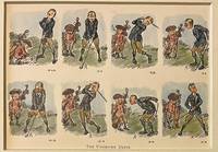
120757-092<strong>Original 1920 lithography bookillustration of golfers on a golf course. A golfer and a caddy with golfclubs. Â </strong>Lithography 145 x 195 in a bigger cardboard passepartout total size 235 x 295 mm. Nice gift for a lover of Golf. The illustration depicts a golferÂ’s failed attempts at making a proper shot. The cartoonÂ’s charming style and expressive sequence capture the lighthearted frustration of early golfing culture.NL Originele lithografie met een golfer en zijn caddy met de titel The Undriven Drive. Engelse bookillustratie. Stripvorm. Satirisch humoristisch. Leuk cadeau voor een liefhebber van golf. Vintage sportcartoon. unknown
8vo. 9 pp. On three bifolia attached to one another with green string. A letter by a member of the British Consulate in Trieste, apparently written to a British official in Cyprus, responding to an enquiry regarding "the probable price of a pair of horses about 15 hands". "The kind of horses that you speak of are known here as 'Jukers', light, active, strong [...], fast trotting, able to go 14 kilometres an hour. A pair of horses of such description 5 years old & sound will cost about fls 1200 or say £100. Hungarian horses in my opinion will suit the best for your Island as they have Arab blood in them". The writer explains that he is not a dealer himself, "but being very fond of horses & having many native friends in India I have very often occasions to buy for them & also for my brother, who resides in Bombay at present". He explains that "no good horses are to be found in Trieste", and that "as a rule" he visits "the fairs in the interior" to buy horses. He names the four breeding farms of the Hungarian Government and describes the types of horses bred at each ("lastly the Fogaras stud, where stallions from the Lipizza private farm belonging to the Emperor are supplied"). Describes the auction of the "superfluous horses of these establishments of the age of 4 & 5" at "Tattersall's in Budapest in the 1st week of October", with prices for each type of horse, giving examples from his own experience. "Two British Cavalry officers belonging to the Egyptian Army came over here in the Autumn of 1896. They bought 60 remounts for the Egyptian cavalry. The Greek Cavalry & Artillery are wholly supplied with horses from Hungary". While discussing "sires for breeding purposes" he mentions that he knows "the Director of the Lipizza farm [...] personally" and gives the price at which he is offered superior horses by him. Ends with details of possible "charge for freight on each horse to Cyprus". - Text clear and complete.
Ink and watercolours on paper, backed with cloth. Calligraphic and armorial headpiece; historiated initials; two coloured illustrations (a hunter loading his gun; a hawk devouring a goose). Four red wax seals. 77 x 55 cms, rolled and stored in a contemporary marbled tube. A certificate of apprenticeship for the hunter Anton Spiallek (Spialleck) of Wiegstädtel near Opava in Silesia, signed by Franz Spialeck (possibly a relation) and four other district hunting officials of Dombrau and Mittel-Suchau (Prostrední Suchá), owned by Richard Baron Mattencloit. The art of hunting had long included falconry also in Silesia, and it was among the favourite pastimes of the nobility.
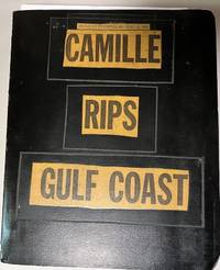
196934699Unknown: n/a 1969. Album. Good. Scrapbook. Approx. 9.5" x 11.5" three ring black binder with title pasted down on the front cover. Back cover of the album has some scuff marks. Contents clean.<br /> <br /> Contents include 43 photographs mounted on black paper magazine and newspaper clippings a Gulf Coast map by Shell Gas Company and a written essay on the hurricane. Original photographs depict scenes of devastated buildings properties etc. A unique collection of visual and printed material regarding one of the most powerful and destructive hurricanes to hit the Gulf coast. n/a unknown
8vo. 14, (2) pp. With portrait frontispiece and folding Arabic facsimile. Original printed wrappers. Rare British pamphlet advertising the independence of Hejaz from Ottoman rule, following the Arab Revolt in which T. E. Lawrence had played so vital a role. Husayn strove for acknowledgement as "King of Arabia", though the powers would recognize him only as King of Hejaz. In 1924 Abd al-Aziz ibn Saud conquered Hejaz and proclaimed the Kingdom of Saudi Arabia six years later. - A clean, unmarked copy. Rare, the last copy at auction sold in 1999 (Sotheby's, Oct 14, 1999, lot 439, £800). OCLC 3949330.
Standard issue, 700 x 1024 mm. Scale 1:50,000. Detailed nautical chart of the approaches to Mina Salman, the primary cargo port and customs point of Bahrain, prepared by the British Admiralty. Undoubtedly one of the better antiquarian maps of northern Bahrain. - The chart details the approaches to Mina Salman as well as the Sitra anchorage. Approach channels to Mina Salman were built in 1954, and a pier was constructed in 1956, mainly used by dhows. In 1958 it became a free port, and in 1962 a deep water wharf composed of six berths was constructed. The wharf allowed cargo to be directly loaded onto the port for the first time. In the 1960s, the port had refrigeration, storage facilities and equipment for handling large ships. - The map includes the cities of Muharraq and Manama, showing numerous minarets. Bahrain Fort, the Portuguese Fort, Abu Mahur Fort, and the Sheikh's palace are labelled. Another prominent site is Muharraq Airfield, a military base established by the Royal Air Force in April 1943 as RAF Bahrain (later RAF Muharraq) that remained in use until 1971, when Bahrain declared independence. - The British Admiralty has produced nautical charts since 1795 under the auspices of the United Kingdom Hydrographic Office (HO). Its main task was to provide the Royal Navy with navigational products and service, but since 1821 it has also sold charts to the public. The present chart was composed after Admiralty surveys from 1932 to 1960. The 1951 first edition saw revisions and corrections in 1962-65. - Very well preserved with a single fold. Provenance: stamps of Maria K. Iatrou, seller of nautical charts, books and instruments in Piraeus, Greece.
Engraved map. 1230 x 690 mm. Detailed British Admiralty chart of the approaches to Jeddah, present-day Saudi Arabia, with an inset chart of Jeddah Harbour and the city itself. - This is undoubtedly one of the better antiquarian maps of the gateway city to Mecca and Medina. Jeddah was an important diplomatic city when the map was made; illustrated are the consulates of Britain, Russia, Austria, the Netherlands, Egypt, and France. Numerous minarets of the old city are shown. The old city walls and the gates of Mecca, Cherif, and Medina are labeled. The Ummina Howwa (Eve's Tomb) is shown. - At the beginning of the 20th century, Jeddah was an important Red Sea port, but with many islands and much shoaling in the approaches, it was a dangerous one. The British Admiralty has produced nautical charts since 1795 under the auspices of the United Kingdom Hydrographic Office (HO). Its main task was to provide the Royal Navy with navigational products and service, but since 1821 it has also sold charts to the public. In 1795, King George III appointed Alexander Dalrymple, a pedantic geographer, to consolidate, catalogue, and improve the Royal Navy’s charts. He produced the first chart as the Hydrographer to the Admiralty in 1802. Dalrymple, known for his sticky personality, served until his death in 1808, when he was succeeded by Captain Thomas Hurd. The HO has been run by naval officers ever since. Hurd professionalized the office and increased its efficiency. He was succeeded by the Arctic explorer Captain William Parry in 1823. By 1825, the HO was offering over 700 charts and views for sale. Under Parry, the HO also began to participate in exploratory expeditions. The first was a joint French-Spanish-British trip to the South Atlantic, a voyage organized in part by the Royal Society of London. In 1829, Rear-Admiral Sir Francis Beaufort was appointed Hydrographer Royal. Under his management, the HO introduced the wind force scale named for him, as well as began issuing official tide tables (1833). It was under Beaufort that HMS Beagle completed several surveying missions, including its most famous voyage commanded by Captain FitzRoy with Charles Darwin onboard. When Beaufort retired in 1855, the HO had nearly two thousand charts in its catalogue. Later in the 19th century, the HO supported the Challenger expedition, which is credited with helping to found the discipline of oceanography. The HO participated in the International Meridian Conference which decided on the Greenwich Meridian as the Prime Meridian. Regulation and standardization of oceanic and navigational measures continued into the 20th century, with the HO participating at the first International Hydrographic Organization meeting in 1921. During World War II, the HO chart making facility moved to Taunton, the first purpose-built building it ever inhabited. In 1953, the first purpose-built survey ship went to sea, the HMS Vidal. Today, there is an entire class of survey vessels that make up the Royal Navy’s Hydrographic Squadron. The HO began to computerize their charts in the late 1960s and early 1970s. In 1968, the compilation staff also came to Taunton, and the HO continues to work from there today.