2 779 résultats
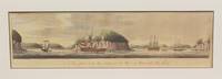
178119326London 1781. Engraved chart the town and border hand-coloured as issued. Minor repaired edge tears. Sheet Size: 22 5/8 x 32 1/2 inches. An important 18th century chart of Louisbourg harbour.<br/> <br/>Des Barres of Swiss-Huguenot extraction studied under the great mathematician Daniel Bernoulli at the University of Basel before continuing on to the Royal Military College at Woolwich. Upon the outbreak of hostilities with France in 1756 he joined the British Royal American Regiment as a military engineer. He came to the attention of General James Wolfe who appointed him to join his personal detail. During this period he also worked with the future legendary explorer James Cook on a monumental chart of the St. Lawrence River. From 1762 Des Barres was enlisted to survey the coastlines of Nova Scotia Newfoundland and the Gulf of St. Lawrence while his colleague Samuel Holland charted the New England coast. He also managed to gain access to some surveys of the American South Cuba and Jamaica. In 1774 Des Barres returned to England where he began work on The Neptune. His dedication to the project was so strong that often at his own expense he continually updated and added new charts and views up until 1784. That year he returned to Canada where he remained for a further forty years becoming a senior political figure and a wealthy land owner and living to the advanced age of 103. The Atlantic Neptune the most celebrated sea atlas contained the first systematic survey of the east coast of North America. Des Barres's synergy of great empirical accuracy with the peerless artistic virtue of his aquatint views created a work that "has been described as the most splendid collection of charts plates and views ever published" National Maritime Museum Catalogue. Upon the conclusion of the Seven Years War Britain's empire in North America was greatly expanded and this required the creation of a master atlas featuring new and accurate sea charts for use by the Royal Navy. Des Barres was charged with this Herculean task publishing the first volume in London in 1775 which was soon followed by three further volumes. Des Barres's monumental endeavor eventually featured over two-hundred charts and views many being found in several states. Des Barres's charts were immensely detailed featuring both hydrographical and topographical information and in many cases remained the most authoritative maps of the regions covered for several decades.<br/> <br/>Stevens 140. unknown books
177734270London: Published by J.F.W. Des Barres in 'The Atlantic Neptune' 1777. Hand-colored etching on Bates paper. No imprint. Sheet size: 32 1/4 x 23 3/4 inches with center fold as with all early issues. Expert restoration to center fold and marginal tears. A set of six navigational views of Halifax Harbour and nearby coastal area from one of the most important North American marine atlases.<br/> <br/> This group includes four profile views intended as aids to navigation. The profiles were intended for use by captains of vessels to identify exactly where they were in relation to distant shorelines; added to these is a charming roundel giving a picturesque view of a waterfall on the Hinchinbroke River and finally a tranquil view in Halifax harbour which is enlivened by the small scene in the lower right of the image where amid clouds of steam men work frantically to re-tar the hull of a man-of-war. This finely coloured example of the print corresponds to Stevens 51 first state without stamped plate number. 'The Atlantic Neptune' was the first great marine atlas and one of the greatest achievements of eighteenth century cartography. Published in England in 1774 it contained over 250 charts and views of the North American and Canadian coasts. The charts were intensely detailed and contained both hydrographical and topographical details. The Neptune was compiled and published for the Royal Navy by Joseph F. W. Des Barres a Swiss cartographer who joined the Royal American Regiment as a surveyor. Des Barres fought in the French and Indian wars and was enlisted to survey the Canadian coastline. While his fellow surveyor Samuel Holland charted the New England coast Des Barres mapped the shoreline of Nova Scotia Newfoundland and the St. Lawrence River regions. In 1774 Des Barres returned to England where he compiled and published his monumental atlas; his dedication to the project was so strong that he published an updated version of the work every year until 1784. Des Barres' work was so superior to any other contemporary atlas that the maps were used as the standard charts of the East coast for over 50 years. The Neptune remains one of the most important atlases ever printed its views and maps chart the history of North America and allow us to glimpse forgotten shores long changed with the passage of time.<br/> <br/> Spendlove The Face of Early Canada Chapter 4: "J.F.W. Des Barres and The Atlantic Neptune"; pp. 18-22; Debard "The Family Origins of Joseph Fredericks Wallet DesBarres: A Riddle Finally Solved" Nova Scotia Historical Review Vol 14 No. 2 1994 p.15; Stevens 51A. Published by J.F.W. Des Barres in 'The Atlantic Neptune' unknown
178134269London: Published by J.F.W. Des Barres in 'The Atlantic Neptune' 1781. Etching with aquatint. Sheet size: 33 x 24 1/4 inches. A portion of the upper left platemark expertly reinforced. 3rd state of 5 Corresponding to Stevens 51 c. A set of six navigational views of Halifax Harbour and nearby coastal area from one of the most important North American marine atlases.<br/> <br/>This group includes four views intended as aids to navigation. The profiles were intended for use by captains of vessels to identify exactly where they were in relation to distant shorelines; added to these is a charming roundel giving a picturesque view of a waterfall on the Hinchinbroke River and finally a tranquil view in Halifax harbour which is enlivened by the small scene in the lower right of the image where amid clouds of steam men work frantically to re-tar the hull of a man-of-war. This later state of the print incorporates all the improvements in detail and the addition of sailing ships of all kinds. 'The Atlantic Neptune' was the first great marine atlas and one of the greatest achievements of eighteenth century cartography. Published in England in 1774 it contained over 250 charts and views of the North American and Canadian coasts. The charts were intensely detailed and contained both hydrographical and topographical details. The Neptune was compiled and published for the Royal Navy by Joseph F. W. Des Barres a Swiss cartographer who joined the Royal American Regiment as a surveyor. Des Barres fought in the French and Indian wars and was enlisted to survey the Canadian coastline. While his fellow surveyor Samuel Holland charted the New England coast Des Barres mapped the shoreline of Nova Scotia Newfoundland and the St. Lawrence River regions. In 1774 Des Barres returned to England where he compiled and published his monumental atlas; his dedication to the project was so strong that he published an updated version of the work every year until 1784. Des Barres' work was so superior to any other contemporary atlas that the maps were used as the standard charts of the East coast for over 50 years. The Neptune remains one of the most important atlases ever printed its views and maps chart the history of North America and allow us to glimpse forgotten shores long changed with the passage of time.<br/> <br/>Spendlove The Face of Early Canada Chapter 4: "J.F.W. Des Barres and The Atlantic Neptune"; pp. 18-22; Debard "The Family Origins of Joseph Fredericks Wallet DesBarres: A Riddle Finally Solved" Nova Scotia Historical Review Vol 14 No. 2 1994 p.15; Catalogue of the Henry Newton Stevens Collection.51c. Published by J.F.W. Des Barres in 'The Atlantic Neptune' unknown books
177734270London: Published by J.F.W. Des Barres in 'The Atlantic Neptune' 1777. Hand-colored etching on Bates paper. No imprint. Sheet size: 32 1/4 x 23 3/4 inches with center fold as with all early issues. Expert restoration to center fold and marginal tears. A set of six navigational views of Halifax Harbour and nearby coastal area from one of the most important North American marine atlases.<br/> <br/>This group includes four profile views intended as aids to navigation. The profiles were intended for use by captains of vessels to identify exactly where they were in relation to distant shorelines; added to these is a charming roundel giving a picturesque view of a waterfall on the Hinchinbroke River and finally a tranquil view in Halifax harbour which is enlivened by the small scene in the lower right of the image where amid clouds of steam men work frantically to re-tar the hull of a man-of-war. This finely coloured example of the print corresponds to Stevens 51 first state without stamped plate number. 'The Atlantic Neptune' was the first great marine atlas and one of the greatest achievements of eighteenth century cartography. Published in England in 1774 it contained over 250 charts and views of the North American and Canadian coasts. The charts were intensely detailed and contained both hydrographical and topographical details. The Neptune was compiled and published for the Royal Navy by Joseph F. W. Des Barres a Swiss cartographer who joined the Royal American Regiment as a surveyor. Des Barres fought in the French and Indian wars and was enlisted to survey the Canadian coastline. While his fellow surveyor Samuel Holland charted the New England coast Des Barres mapped the shoreline of Nova Scotia Newfoundland and the St. Lawrence River regions. In 1774 Des Barres returned to England where he compiled and published his monumental atlas; his dedication to the project was so strong that he published an updated version of the work every year until 1784. Des Barres' work was so superior to any other contemporary atlas that the maps were used as the standard charts of the East coast for over 50 years. The Neptune remains one of the most important atlases ever printed its views and maps chart the history of North America and allow us to glimpse forgotten shores long changed with the passage of time.<br/> <br/>Spendlove The Face of Early Canada Chapter 4: "J.F.W. Des Barres and The Atlantic Neptune"; pp. 18-22; Debard "The Family Origins of Joseph Fredericks Wallet DesBarres: A Riddle Finally Solved" Nova Scotia Historical Review Vol 14 No. 2 1994 p.15; Stevens 51A. Published by J.F.W. Des Barres in 'The Atlantic Neptune' unknown books
192193748Paris Cercle de la Librairie 1921 1 vol. broché in-4, broché, IX + 247 pp., 66 portraits photographiques hors-texte reproduits à l'héliogravure. Préface de Maurice Barrès en originale. Impression soignée sur vélin chiffon à la forme. Excellent état.
192193748Paris Cercle de la Librairie 1921 1 vol. broché in-4, broché, IX + 247 pp., 66 portraits photographiques hors-texte reproduits à l'héliogravure. Préface de Maurice Barrès en originale. Impression soignée sur vélin chiffon à la forme. Excellent état.
848703S.N. S.L. 1988 In-8 ( 240 X 160 mm ) de 188 pages, broché sous couverture illustrée. Illustrations dans et hors-texte. Très bel exemplaire.
177933200London 1779. Engraved and aquatint map period hand colouring. 14 lettered references large inset with title as above. Rare revolutionary chart of the Hudson River showing the American defenses on the eve of the Battle of Fort Montgomery.<br/> <br/> On October 6 1777 a British force led by Lieutenant General Sir Henry Clinton attacked Forts Montgomery and Clinton from the landward side where the American defenses were only partially completed. Support from cannon fire from British ships on the Hudson River that had passed through the chevaux de frise on the lower river. By the end of the day both forts had fallen to the British who burned the forts and tore down the stonework buildings. However the battle was a pyrrhic victory for the British. The campaign against the forts caused delays in reinforcing General John Burgoyne at Saratoga where Americans forced the British surrender ten days later at the Battle of Saratoga before Clinton's forces could arrive. The present map which depicts the Forts and the River defenses prior to the battle is from The Atlantic Neptune the finest large scale sea atlas of the United States and Canadian Atlantic coastline ever produced. The maps in the atlas were produced over a seven-year period 1775-82 and are well known for their accurate portrayal of various sounds bays bars harbors as well as navigational hazards. This atlas was used extensively by the Royal Navy during the American Revolution. Des Barres studied under the great mathematician Daniel Bernoulli at the University of Basel before continuing on to the Royal Military College at Woolwich. On the outbreak of the Seven Years war in 1756 he joined the British Royal American Regiment as a military engineer. He came to the attention of General James Wolfe who appointed him to be his aide-de-camp. From 1762 Des Barres was enlisted to survey the coastlines of Nova Scotia Newfoundland and the Gulf of St.Lawrence while his colleague Samuel Holland charted the New England coast and further south. In 1774 Des Barres returned to England where he began work on the Neptune. His dedication to the project was so strong that often at his own expense he continually updated and added new charts and views up until 1784. That year he returned to Canada where he remained for a further forty years becoming a senior political figure and a wealthy land owner and living to the advanced age of 103. The Atlantic Neptune was the first British sea atlas of her North American colonies and one of the most important achievements of eighteenth century cartography. With an official commission from the Royal Navy Des Barres published the first volume in London in 1775 which was soon followed by further volumes. Des Barres' monumental endeavor eventually featured over two-hundred charts and aquatint views many being found in several states. All of the charts were immensely detailed featuring both hydrographical and topographical information. The Neptune met with the highest acclaim from the beginning and is today widely regarded as superior to all other atlases produced during its time. Henry Stevens identified only a single state of this chart issued coloured or uncoloured which appeared in some examples volume four part two of the Atlantic Nepture; the map however is not listed in the engraved list of maps for that section and given the rarity was likely not issued in all copies.<br/> <br/> National Maritime Museum: Henry Stevens Collection: HNS156; Cf. Phillips Atlases 1198; Hornsby Surveyors of Empire: Samuel Holland J.F.W. Des Barres and the Making of the Atlantic Neptune 2011. unknown
177933200London 1779. Engraved and aquatint map period hand colouring. 14 lettered references large inset with title as above. Rare revolutionary chart of the Hudson River showing the American defenses on the eve of the Battle of Fort Montgomery.<br/> <br/>On October 6 1777 a British force led by Lieutenant General Sir Henry Clinton attacked Forts Montgomery and Clinton from the landward side where the American defenses were only partially completed. Support from cannon fire from British ships on the Hudson River that had passed through the chevaux de frise on the lower river. By the end of the day both forts had fallen to the British who burned the forts and tore down the stonework buildings. However the battle was a pyrrhic victory for the British. The campaign against the forts caused delays in reinforcing General John Burgoyne at Saratoga where Americans forced the British surrender ten days later at the Battle of Saratoga before Clinton's forces could arrive. The present map which depicts the Forts and the River defenses prior to the battle is from The Atlantic Neptune the finest large scale sea atlas of the United States and Canadian Atlantic coastline ever produced. The maps in the atlas were produced over a seven-year period 1775-82 and are well known for their accurate portrayal of various sounds bays bars harbors as well as navigational hazards. This atlas was used extensively by the Royal Navy during the American Revolution. Des Barres studied under the great mathematician Daniel Bernoulli at the University of Basel before continuing on to the Royal Military College at Woolwich. On the outbreak of the Seven Years war in 1756 he joined the British Royal American Regiment as a military engineer. He came to the attention of General James Wolfe who appointed him to be his aide-de-camp. From 1762 Des Barres was enlisted to survey the coastlines of Nova Scotia Newfoundland and the Gulf of St.Lawrence while his colleague Samuel Holland charted the New England coast and further south. In 1774 Des Barres returned to England where he began work on the Neptune. His dedication to the project was so strong that often at his own expense he continually updated and added new charts and views up until 1784. That year he returned to Canada where he remained for a further forty years becoming a senior political figure and a wealthy land owner and living to the advanced age of 103. The Atlantic Neptune was the first British sea atlas of her North American colonies and one of the most important achievements of eighteenth century cartography. With an official commission from the Royal Navy Des Barres published the first volume in London in 1775 which was soon followed by further volumes. Des Barres' monumental endeavor eventually featured over two-hundred charts and aquatint views many being found in several states. All of the charts were immensely detailed featuring both hydrographical and topographical information. The Neptune met with the highest acclaim from the beginning and is today widely regarded as superior to all other atlases produced during its time. Henry Stevens identified only a single state of this chart issued coloured or uncoloured which appeared in some examples volume four part two of the Atlantic Nepture; the map however is not listed in the engraved list of maps for that section and given the rarity was likely not issued in all copies.<br/> <br/>National Maritime Museum: Henry Stevens Collection: HNS156; Cf. Phillips Atlases 1198; Hornsby Surveyors of Empire: Samuel Holland J.F.W. Des Barres and the Making of the Atlantic Neptune 2011. unknown books
1385766786.Ghardcover. Good. Access codes and supplements are not guaranteed with used items. May be an ex-library book. hardcover
R150184765FAYARD. Non daté. In-8. Relié demi-cuir. Etat d'usage, Coins frottés, Dos frotté, Intérieur acceptable. 206 + 125 + 123 + 126 + 156 + 123 pages. Frontispice en noir et blanc an face de chaque page de titre. Nombreuses illustrations en noir et blanc dans le texte et hors texte. Couverture déboitée.. . . . Classification Dewey : 840-Littératures des langues romanes. Littérature française
178133877London: Published by J.F.W. Des Barres in 'The Atlantic Neptune' 1781. Etching with aquatint. Printed on laid paper with `J. Bates' watermark and `JB' countermark. Skillful marginal restoration in several places. One of the most desirable large-scale views from the 'The Atlantic Neptune' the first British sea atlas of her North American colonies.<br/> <br/>In this fine scene Des Barres depicts his own men camping beneath the hills that form the spine of Sable Island the 20 mile-long shifting sandbar that lies 111 miles off the coast of Halifax. From 1766 to 1768 Des Barres and his party spent two seasons surveying the waters around Sable Island. The island is known for both for its wild horses depicted here and more ominously. as the "Graveyard of the Atlantic." The island is the last offshore remnant from the time when the sea levels were much lower. It is theorized that the vast mound of sand that forms the island was deposited there by glaciers at the end of the last ice age. The shifting nature of the shoals off the island allied with treacherous sea currents have meant that until the invention of modern navigational techniques it was extremely hazardous to ships. Over 350 wrecks have been recorded since 1583 the most recent in July 1999. The horses on the island now numbering about 200 are probably descended from stock belonging to the Acadians of Nova Scotia. In 1760 the Boston merchant Thomas Hancock shipped 60 Acadian horses to Sable island where they have bred and flourished ever since. The isolated nature of the herd means that they provide insights into the type of animal that was favoured by the eighteenth-century settlers. This view is the fourth and final state produced and is identical to the Henry Stevens Collection variant 77D in the National Maritime Museum Greenwich. Des Barres studied under the great mathematician Daniel Bernoulli at the University of Basel before continuing on to the Royal Military College at Woolwich. On the outbreak of the Seven Years war in 1756 he joined the British Royal American Regiment as a military engineer. He came the attention of General James Wolfe who appointed him to be his aide-de-camp. From 1762 Des Barres was enlisted to survey the coastlines of Nova Scotia Newfoundland and the Gulf of St.Lawrence while his colleague Samuel Holland charted the New England coast. In 1774 Des Barres returned to England where he began work on the Neptune. His dedication to the project was so strong that often at his own expense he continually updated and added new charts and views up until 1784. That year he returned to Canada where he remained for a further forty years becoming a senior political figure and a wealthy land owner and living to the advanced age of 103. The Atlantic Neptune was the first British sea atlas of her North American colonies and one of the most important achievements of eighteenth century cartography. With an official commission from the Royal Navy Des Barres published the first volume in London in 1775 which was soon followed by further volumes. Des Barres' monumental endeavor eventually featured over two-hundred charts and aquatint views many being found in several states. All of the charts were immensely detailed featuring both hydrographical and topographical information. Des Barres' plates were used to print further editions up into the first decade of the nineteenth-century. The Neptune met with the highest acclaim from the beginning and is today widely regarded as superior to all other atlases produced during its time.<br/> <br/>Spendlove The Face of Early Canada Chapter 4: "J.F.W. Des Barres and The Atlantic Neptune"; pp. 18-22; Debard "The Family Origins of Joseph Fredericks Wallet DesBarres: A Riddle Finally Solved" Nova Scotia Historical Review Vol 14 No. 2 1994 p.15; National Maritime Museum: Henry Stevens Collection: K0252 HNS 77D &Catalogue no.62-66 p.383; Phillips p.634. Published by J.F.W. Des Barres in 'The Atlantic Neptune' unknown books
1775P739London 1775. Excellent. Notes: Aquatint and line engraving. This fine view is from "The Atlantic Neptune" by Capt. Joseph Fredrick Wallet Des Barres 1721-1824. "The Atlantic Neptune" is one of the most important sea atlases of USA and Canadian Atlantic coast that was ever produced. The atlas was first published in England in 1774 and was updated regularly till 1784. The maps are known for the accurate portrayal of various sounds bays bars and harbours in addition to navigational challenges. The maps are very detailed and contain both hydrographical and topographical information. Des Barres a Swiss cartographer and landscape artist who immigrated to England and trained at the royal military academy became a colonial administrator in Halifax Nova Scotia where he died. He was lieutenant royal American regiment c 1756; engineer under general wolf at Quebec c.1759; and governor of Prince Edward Island. He mapped the shore line of Nova Scotia New Found land and St. Lawrence River regions c.1764/1774 . This atlas was used by the Royal Navy during the American Revolution. <br>Reference Debard J. M. the family origins of J.f.W.Des Barres; Evens uncommon Obdurate: the several public careers of J.F.W. Des Barres Toronto 1989; De Vorsey map collector 1982 p.31 Image Size : 184x793 mm 7.25x31.25 Inches Platemark Size : Paper Size : 278x823 mm 11x32.375 Inches Coloring: Hand Colored Medium: Aquatint and line engraving Categories: Views Canada Nova Scotia unknown
177634921London: J. F. W. Des Barres 1776. Engraved view printed on laid paper engraved by James Newton after Pierie. Sheet size: 22 1/2 x 31 1/2 inches. First state. Rare view of Boston from the road to Dorchester published shortly after George Washington's first victory of the American Revolution.<br/> <br/> Following the Battles of Lexington and Concord American troops laid siege to Boston. Strategically Dorchester Heights offered commanding views of both Boston town and harbour. On March 4 1776 under the cover of darkness and with batteries firing from Roxbury and Cambridge to provide a diversion George Washington moved canon captured at Ticonderoga onto the Heights and fortified the position. Faced with little choice given the overwhelming strategic advantage General Howe retreated from Boston on March 17 giving George Washington and the Americans a decisive early victory in the war. The present view accomplished by British artillery officer William Pierie in 1773 depicts Boston Boston Harbor and Roxbury as it would have been seen by Washington and the American army. The Shirley-Eustis house the home of Governor William Shirley and later Governor William Eustis in Roxbury is visible in the middle ground and in the far distance the beacon is visible atop Beacon Hill. A rare view published in 1776 in the New England section of Des Barres monumental Atlantic Neptune. Joseph Frederick Wallet Des Barres was born in Switzerland where his Huguenot ancestors had fled following the repeal of the Edict of Nantes. He studied under the great mathematician Daniel Bernoulli at the University of Basel before immigrating to Britain where he trained at the Royal Military College Woolwich. Upon the outbreak of hostilities with France in 1756 he joined the British Royal American Regiment as a military engineer. He came to the attention of General James Wolfe who appointed him to join his personal detail. Des Barres returned to London in 1774 where the Royal Navy charged him with the Herculean task of producing an atlas of sea charts of the American coast. The result was The Atlantic Neptune which became the most celebrated sea atlas of its era containing the first systematic survey of the east coast of North America. Des Barres's synergy of great empirical accuracy with the peerless artistic virtue of his aquatint views created a work that "has been described as the most splendid collection of charts plates and views ever published" National Maritime Museum Catalogue. The Neptune eventually consisted of four volumes and Des Barres's dedication to the project was so strong that often at his own expense he continually updated and added new charts and views to various editions up until 1784 producing over 250 charts and views many appearing in several variations. Following the completion of The Neptune Des Barres returned to Canada where he remained for a further forty years becoming a senior political figure and a wealthy land owner living to the advanced age of 103.<br/> <br/> Henry Stevens Collection HNS97; Deak 132. J. F. W. Des Barres unknown
177634921London: J. F. W. Des Barres 1776. Engraved view printed on laid paper engraved by James Newton after Pierie. Sheet size: 22 1/2 x 31 1/2 inches. First state. Repaired tears in lower margin. Rare view of Boston from Dorchester Heights published shortly after George Washington's first victory of the American Revolution.<br/> <br/>Following the Battles of Lexington and Concord American troops laid siege to Boston. Strategically Dorchester Heights offered commanding views of both Boston town and harbour. On March 4 1776 under the cover of darkness and with batteries firing from Roxbury and Cambridge to provide a diversion George Washington moved canon captured at Ticonderoga onto the Heights and fortified the position. Faced with little choice given the overwhelming strategic advantage General Howe retreated from Boston on March 17 giving George Washington and the Americans a decisive early victory in the war. The present view accomplished by British artillery officer William Pierie in 1773 depicts Boston Boston Harbor and Roxbury as it would have been seen by Washington and the American army. The Shirley-Eustis house the home of Governor William Shirley and later Governor William Eustis in Roxbury is visible in the middle ground and in the far distance the beacon is visible atop Beacon Hill. A rare view published in 1776 in the New England section of Des Barres monumental Atlantic Neptune. Joseph Frederick Wallet Des Barres was born in Switzerland where his Huguenot ancestors had fled following the repeal of the Edict of Nantes. He studied under the great mathematician Daniel Bernoulli at the University of Basel before immigrating to Britain where he trained at the Royal Military College Woolwich. Upon the outbreak of hostilities with France in 1756 he joined the British Royal American Regiment as a military engineer. He came to the attention of General James Wolfe who appointed him to join his personal detail. Des Barres returned to London in 1774 where the Royal Navy charged him with the Herculean task of producing an atlas of sea charts of the American coast. The result was The Atlantic Neptune which became the most celebrated sea atlas of its era containing the first systematic survey of the east coast of North America. Des Barres's synergy of great empirical accuracy with the peerless artistic virtue of his aquatint views created a work that "has been described as the most splendid collection of charts plates and views ever published" National Maritime Museum Catalogue. The Neptune eventually consisted of four volumes and Des Barres's dedication to the project was so strong that often at his own expense he continually updated and added new charts and views to various editions up until 1784 producing over 250 charts and views many appearing in several variations. Following the completion of The Neptune Des Barres returned to Canada where he remained for a further forty years becoming a senior political figure and a wealthy land owner living to the advanced age of 103.<br/> <br/>Henry Stevens Collection HNS97; Deak 132. J. F. W. Des Barres unknown books
178013223London: Published by J.F.W. Des Barres in 'The Atlantic Neptune' 1780. Etching with aquatint printed in sepia. On laid paper with 'J Bates' watermark and 'JB' countermark. Expertly repaired 1/2 inch hole to image. A very fine view of Quebec. This image is one of the most important of all the views included in Des Barres masterpiece: 'The Atlantic Neptune'.<br/> <br/>'The Atlantic Neptune' was the first great marine atlas and one of the greatest achievements of eighteenth century cartography. Published in England in 1774 it contained over 250 charts and views of the North American and Canadian coasts. The charts were intensely detailed and contained both hydrographical and topographical details. The Neptune was compiled and published for the Royal Navy by Joseph F. W. Des Barres a Swiss cartographer who joined the Royal American Regiment as a surveyor. Des Barres fought in the French and Indian wars and was enlisted to survey the Canadian coastline. While his fellow surveyor Samuel Holland charted the New England coast Des Barres mapped the shoreline of Nova Scotia Newfoundland and the St. Lawrence River regions. In 1774 Des Barres returned to England where he compiled and published his monumental atlas; his dedication to the project was so strong that he published an updated version of the work every year until 1784. Des Barres' work was so superior to any other contemporary atlas that the maps were used as the standard charts of the East coast for over 50 years. The Neptune remains one of the most important atlases ever printed its views and maps chart the history of Canada and the United states and allow us to glimpse a forgotten land long changed by the passage of time. Spendlove writes that the 'large prints from The Atlantic Neptune are among the finest and most beautiful pictures of Canada ever made. Des Barres was an artist of great ability. and his delineation of ships was particularly effective and one could hardly find anything finer' The Face of Early Canada pp. 18-19. The present view is apparently taken from on board a ship on the St. Lawrence River looking north west towards towards the citadel and burgeoning city of Quebec. In the foreground are two finely-observed merchantmen their flags and pennants streaming out in the stiff breeze blowing up the river valley. This is an historically important image of Quebec as it looked twenty years after its capture by Wolfe drawn by an artist of high merit who took part in the 1759 campaign. Second state of 2<br/> <br/>National Maritime Museum Greenwich Henry Newton Stevens Collection 125a; Cf. Spendlove The Face of Early Canada Chapter 4: "J.F.W. Des Barres and The Atlantic Neptune"; pp. 18-22; Debard "The Family Origins of Joseph Fredericks Wallet DesBarres: A Riddle Finally Solved" Nova Scotia Historical Review Vol 14 No. 2 1994 p.15; Stevens 125B. Published by J.F.W. Des Barres in 'The Atlantic Neptune' unknown books
17813608London: Published by J.F.W Des Barres in 'The Atlantic Neptune' 1781. Etching with aquatint printed in sepia. Printed on laid paper with watermark `J Bates' and countermark `JB'. A large-scale view of the scenery near Lakevale and Antigonish on the North West coast of Nova Scotia from 'The Atlantic Neptune' the first British sea atlas of her North American colonies<br/> <br/>This is a very fine scene depicting a dramatic point where the highlands of Nova Scotia cascade into the Gulf of St. Lawrence. This is the second state of this view and is identical to the Henry Stevens Collection variant 70B in the National Maritime Museum Greenwich. Des Barres studied under the great mathematician Daniel Bernoulli at the University of Basel before continuing on to the Royal Military College at Woolwich. On the outbreak of the Seven Years war in 1756 he joined the British Royal American Regiment as a military engineer. He came the attention of General James Wolfe who appointed him to be his aide-de-camp. From 1762 Des Barres was enlisted to survey the coastlines of Nova Scotia Newfoundland and the Gulf of St.Lawrence while his colleague Samuel Holland charted the New England coast. In 1774 Des Barres returned to England where he began work on the Neptune. His dedication to the project was so strong that often at his own expense he continually updated and added new charts and views up until 1784. That year he returned to Canada where he remained for a further forty years becoming a senior political figure and a wealthy land owner and living to the advanced age of 103. The Atlantic Neptune was the first British sea atlas of her North American colonies and one of the most important achievements of eighteenth century cartography. With an official commission from the Royal Navy Des Barres published the first volume in London in 1775 which was soon followed by further volumes. Des Barres' monumental endeavor eventually featured over two-hundred charts and aquatint views many being found in several states. All of the charts were immensely detailed featuring both hydrographical and topographical information. Des Barres' plates were used to print further editions up into the first decade of the nineteenth-century. The Neptune met with the highest acclaim from the beginning and is today widely regarded as superior to all other atlases produced during its time.<br/> <br/>Spendlove The Face of Early Canada Chapter 4: "J.F.W. Des Barres and The Atlantic Neptune"; pp. 18-22; Debard "The Family Origins of Joseph Fredericks Wallet DesBarres: A Riddle Finally Solved" Nova Scotia Historical Review Vol 14 No. 2 1994 p.15; National Maritime Museum: Henry Stevens Collection: K0231 HNS 70B. Published by J.F.W Des Barres in 'The Atlantic Neptune' unknown books
11390BREST, Lefournier / QUIMPER, Salaun - sans date, 1850 (?) - Pemped édition - In-16 - 1/2 reliure frottée - Dos lisse, filets dorés - Langue bretonne - 359 pages - Intérieur propre
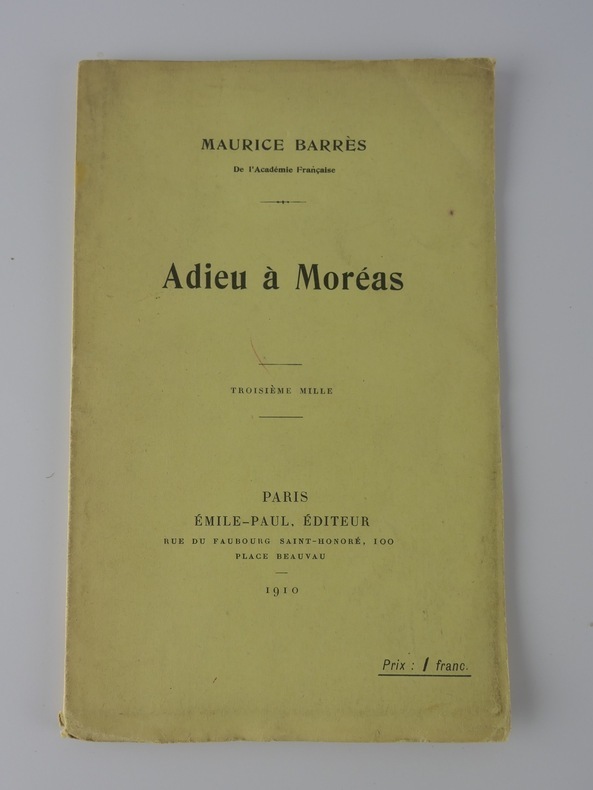
1910RO20141746EMILE-PAUL. 1910. In-12. Broché. Etat d'usage, Couv. convenable, Dos satisfaisant, Quelques rousseurs. 18 pages.. . . . Classification Dewey : 840.091-XX ème siècle
0332154467.Ghardcover. Good. Access codes and supplements are not guaranteed with used items. May be an ex-library book. hardcover
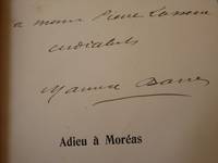
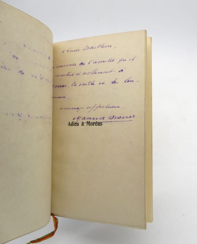
191040407Paris: Emile-Paul frères 1910. Fine. Emile-Paul frères Paris 1910 12 x 19 cm broché First edition one of the numbered advance copies from the first printing. Signed and inscribed by Maurice Barrès to Pierre Lasserre. Some minor worming of no consequence. Emile-Paul frères unknown
19845Paris, Émile-Paul frères, 1910. In-12, 18 pp., bradel de papier marbré vert moderne, dos long, tête dorée, couverture conservée (petits frottements des coiffes, taches d'encre en regard de l'envoi).
191080001Paris, Emile-Paul, 1910, 12x18,5cm, broché, 18p. Exemplaire du premier tirage sans grand papier justifié 629 à la presse. Bon état.
191080002Paris, Emile-Paul, 1910, 12x18,5cm, broché, 18p. Exemplaire du troisième mille justifié 2167 à la presse. Bon état.
19104370Emile-Paul | Paris 1910 | 12 x 19 cm | broché