Bauman Richard ALivre Rare Book
610 résultats
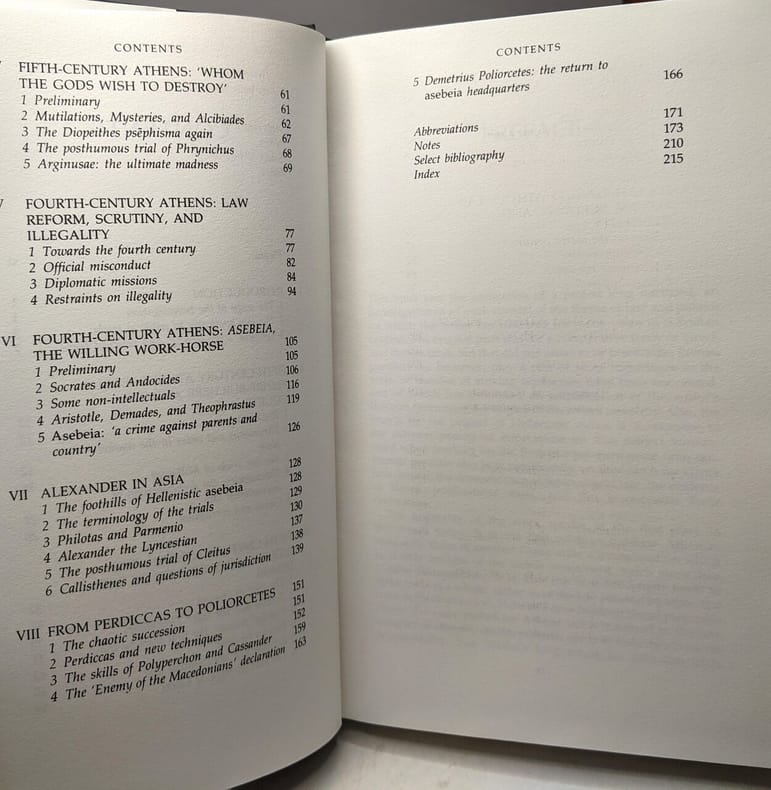
1990100133203Routledge 1990 240 pages 5x25x20cm. 1990. Cartonné jaquette. 240 pages.
31829Athènes, Laboratoire de géologie de l'Université, 1956 - grand in-4 broché, XVIII+358 pages, 7 tableaux et 77 figures in texte, 1 tableau dépliant et 20 planches commentées hors texte. L'ouvrage est accompagné d'une enveloppe contenant la carte géologique du Pinde septentrional et d'une partie de de la Macédoine occidentale (dépliante et en couleurs) à l'échelle 1/200.000. Le tout est réuni dans un emboitage cartonné avec titre au dos - Exemplaire avec dédicace autographe de l'auteur sur page de titre - Thèse présentée à la Faculté des Sciences de l'Université de Paris pour obtenir le grade de Docteur és-sciences naturelles - Très bon état
2661Paris, Fontemoing - E. de Boccard, brochés, 16,5x25,5 cm, Tome 1 (2vol) : 496 pages, 1ère partie : JAVAN (jusqu'en 480) 1917 - 2ème partie : JAVAN : L'Orient et les Grecs, 1919, (rousseurs), 1 carte dépliante - tome 2 : ATHENES (480-330), 1913, 512 pages, 1 carte dépliante en couleurs (rousseurs sur couverture) - tome 3 : LA MACEDOINE, CARTHAGE ET ROME (330-107) 1914, 486 pages, 1 carte dépliante en couleurs (quelques rousseurs) - Index général : 1920, 110 pages. (poids : 4,2 kgs)
1988176861988. Athènes Institut Français 1988 2ème ed. - 2 volumes brochés 17 cm x 24 cm XXVI+ 682 pages 1 carte dépliante hors-texte - Texte de Jean N. Kalleris importante bibliographie abr. techniques sources index toponymie - Etat neuf ; le tome III annoncé n'est jamais paru
1913164271913. Paris Librairie Chapelot 1913 - Broché 14 cm x 23 cm 120 pages bien complet des 2 cartes hors-texte - Texte du Lieutenant-Colonel Boucabeille - Bon état
Mm 110x195 Volume rilegato in mezza tela con titolo in oro al dorso, 62-(2) pagine con una cartina dei luoghi applicata in chiusura del volume. Opera non comune di difficile reperibilità. Libro in ottime condizioni; spedizione in 24 ore dalla conferma dell'ordine.
Book shows light shelf wear to covers. Text/interior is clean and free of marking of any kind. 168 pages with b&w photos, color photo section at back. Contents include Ritual dances, in five sections: Rougatsdria or Rogatsaria, Carnival or Apokries, Anasteenaria or fire-dancing, Lazarines, Tzamala, Regional Dances and Style: Cyclades Dodecanese islands, Sporades, Ionian Islands, Saronic Islands, Norther and Central Aegean, Crete Mainland Dances and Style : Peloponnesos, Attki, Roumeli, Thessaly, Epiros, Macedonia, W. & E. Trace; Vlachs, Arvanites, Sarakatsans: Vlachs, Albanians, Sarakatsans & Asia Minor : Pontos, Cappadocia, Constantinople & Coastal regions et al.
Very Good Turkish, Ottoman (1500-1928) Original color map of Erzurum city center and it environment. Folded. 69x42,5 cm. In Ottoman script. One sheet. Shows center of Erzurum city and topography environment. No scale info. Hegira: 1336 = Gregorian: 1920. Not description on map-maker. This is one the serie of the Bonn projection maps which are the first map series in modern techniques in Turkey and the Ottoman Empire. In order to produce these maps covering Turkish territory, Reconnaissance Branch was incorporated into The Mapping Commission. The maps were produced in the datum based on the latitude and longitude of Ayasofya Mosque in equal area Bonn Projection. The field works for the 123 sheets covering the country were conducted by 76 staff. The production was completed in 18 years starting from east west. Field works continued without stopping except in years 1914 and 1920. This map series called also reconnaissance maps contributed a lot to producing 1:25.000 scale maps. Extremely rare.
Very Good Turkish Original manuscript map on cloth. Chipped margins, stains on cloth. Folded. Oblong folio. (32x35 cm) In modern Turkish. Sealed. It shows the exploration of an area of ??1487 hectares and some stone and brick mosques, fountains, buildings and geographic status of the region in the upper corner. Scale: 1:25.000. Extremely rare.
Laminate lifting from DJ in places along spine. DJ has chipping to spine ends. DJ is price-clipped. Scholar's name to ffep. ; 64 pp of collotype plates, 12 colour photographs on 8 photogravure plates, three folding maps at rear, includes almost 300 photographs taken by the author plus numerous in-text illustrations; 4to 11" - 13" tall; 263 pages
ria9783486252606_inpHardcover. New. New Book; Fast Shipping from UK; Not signed; Not First Edition; N/A hardcover
Very Good German Original color map on cloth. A little foxing on cloth. Very good. Folded. Folio. (51 x 46 cm). In German with Greek place names in Latin script. [MAP of TURKISH BALKANS] Phthiotis, Canal Atalanti, I. Euboea (Evvia, Evripos, Negroponte, Golf v. Volo (Pagasetikos), Skiathos, Skopelos (Peparethos), Chiliodromia (Ikos), Magnesia, Cholkis. (Longitude given from Paris). Scarce.
Very Good English Paperback. 4to. (29 x 21 cm). In English and Macedonian. [2], [iv], 252, [2] p. Introduction.; Public libraries.; Special libraries.; University libraries.; School libraries.; Index of public librarses and libraries according to places.; Name index of libraries. Second Edition.
Very Good Turkish, Ottoman (1500-1928) Original color map on cloth. Folded. Wrinkled on paper. Stains on cloth. 12 sheets on paper. Oblong atlas folio. (50 x 60 cm). In Ottoman script.[MAP of ALEXANDRETTA] Iskenderun - Tayakadin. It shows villages and settlements in Tayakadin of Iskenderiye. Scale: 1/25.000. Hegira: 1329 = Gregorian: 1913. This is one the serie of the Bonn projection maps which are the first map series in modern techniques in Turkey and the Ottoman Empire. In order to produce these maps covering Turkish territory, Reconnaissance Branch was incorporated into The Mapping Commission. The maps were produced in the datum based on the latitude and longitude of Ayasofya Mosque in equal area Bonn Projection. The field works for the 123 sheets covering the country were conducted by 76 staff. The production was completed in 18 years starting from east west. Field works continued without stopping except in years 1914 and 1920. This map series called also reconnaissance maps contributed a lot to producing 1:25.000 scale maps. Not description on map-maker. A very detailed map. Extremely rare.
17 cm, br. edit, stemma al piatto; pp. xii, 482; alcune tab. una carta geografica a col. più volte ripiegata
New English Paperback. Pbo. Roy. 8vo. (24 x 17 cm). In English. 2 volumes set: (616 p.; 502 p.). Ottoman diplomatic documents on the origins of World War One IV: The Macedonian issue 1879-1912. 2 volumes set.
Light discoloration to DJ spine. ; 224 pages; Philip II of Macedon is a unique compilation of fragments of ancient writings, epitomies, and passages from the orators that together form a contemporary biography of one of the most influential figures of the ancient world. Alfred Bradford has collected, translated, and integrated all the significant classical writings about Philip II, the father of Alexander the Great, and he presents them in a readable and lively manner, telling the story of Philip from his precarious childhood, when his life was threatened by his own mother, to his bloody death, when he was murdered by a bodyguard. The book includes useful maps, as well as illustrations based on ancient artifacts.
Minor edgewear to DJ with light chipping to DJ upper corners. One corner is bumped. Gift inscription from author to ffep. Very light shelfwear to book. ; A study in depth of the rise to power of Macedon under the astute leadership of Philip II, whose diplomatic adroitness and military skill paved the way for the career of his son and heir, Alexander the Great. ; Aspects of Greek and Roman life; 312 pages; Signed by Author
Dustjacket has very minor shelfwear. ; 0.5 x 8.69 x 5.55 Inches; 88 pages; Blunt, honest and tenacious, Antigonus II Gonatas assumed the title King of Macedonia in 283 BC and reigned for more than forty years. Pragmatic and occasionally ruthless, he was a well-educated man with a keen interest in philosophy. He gathered about him poets, philosophers and historians; his long reign, despite vicissitudes, re-established Macedonia as a nation. Janice J. Gabbert portrays the eventful life of this enigmatic king in a lively and engaging manner. Her aim is to trace the political career of a man about whose life almost no official records survive. Taking into account the most recent epigraphical evidence, the author brings to life a fascinating political figure. This is the first study entirely devoted to Antigonus for over eighty years.
Dustjacket has very minor shelfwear. ; 0.5 x 8.69 x 5.55 Inches; 88 pages; Blunt, honest and tenacious, Antigonus II Gonatas assumed the title King of Macedonia in 283 BC and reigned for more than forty years. Pragmatic and occasionally ruthless, he was a well-educated man with a keen interest in philosophy. He gathered about him poets, philosophers and historians; his long reign, despite vicissitudes, re-established Macedonia as a nation. Janice J. Gabbert portrays the eventful life of this enigmatic king in a lively and engaging manner. Her aim is to trace the political career of a man about whose life almost no official records survive. Taking into account the most recent epigraphical evidence, the author brings to life a fascinating political figure. This is the first study entirely devoted to Antigonus for over eighty years.
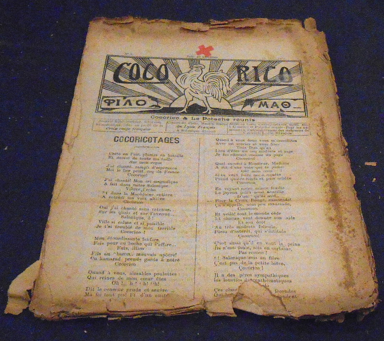
191622266Cocorico & Le Potache Réunis Salonique, Journal hebdomadaire littéraire et humoristique des classes de philo, math’s et rhéto du Lycée Français, numéros 5 (18 mars 1916), 6, 9, 10, 11, 12, 15, et 16 (4 juin 1916) soient 8 numéros. Plié, 24 cm x 32 cm, 8 pages. articles non signés ou sous pseudonyme, publicités pour la salle de cinéma français. Plus ou moins bon état
8vo; x, 109, 227, x pages; Publication no. 75. Bibliography on pages 223-227. In Hebrew & English. "Based chiefly on the Historia de preliis, by Leo, archpresbyter." Slight wear on binding and corners of cover. Note: inscribed from the author to Yosef Goldstein-Eizenthal. Otherwise, very good condition. (k-mx2-4)
8vo; x, 109, 227, x pages; Publication no. 75. Bibliography on pages 223-227. In Hebrew & English. "Based chiefly on the Historia de preliis, by Leo, archpresbyter." No dust jacket, otherwise like new condition. (k-mx2-4A)
8vo; x, 109, 227, x pages; Publication no. 75. Bibliography on pages 223-227. In Hebrew & English. "Based chiefly on the Historia de preliis, by Leo, archpresbyter." Book plate on endpage (Rabbi Stanley Platek), no dust jacket, very good condition +. (k-mx2-4B)