J B TardieuBiblio.com
628 résultats
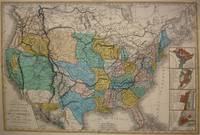
1848M7518Paris: A. Bes & F. Dubreuil Fils c. 1848. Very Good. Folding map flattened and backed acid-free tissue paper for long-term preservation. Two marginal tears repaired expertly. Notes: A scarce large-scale map of the Mexican-American War era and of the entire West. <br><br>To the very north the boundaries of the United States extend well into future British Columbia and within the current states of Washington and Oregon is carved the District of Columbia which was owned by the British. California Arizona and Nevada are together and California's central valley is highlighted for its gold deposits.<br><br>The map is based upon the Eustache Herisson map of the United States 1799 and its major cities. As various publications were made 1826 1834 the map started to take shape. Various projections of the Rocky Mountains were used based off of the Humboldt and Pike projections. Much of the Northwest is based off of the Lewis and Clark expedition. <br><br>This particular map is a scarce and important example as it focuses on the changes brought about by the Mexican-American War. The major differences in this regard are a small inset map of Central America and the delineation of the Mexican-American border; as this map shows all the territory that the United States had captured since the onset of the war. <br><br>Five inset maps depict Mexico and the cities of Washington Boston Philadelphia and New York. Size : 509x662 mm 20.04x26.06 Inches Coloring: Original Hand Coloring Category: Maps United States; A. Bes & F. Dubreuil Fils unknown
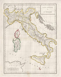
17985441798. Copper-line engraving with later hand-colouring. 450mm by 350mm platemark. French copper-line engraved map of Italy and Sicily with later outline hand-colouring. Published in Paris 1798.<br /> Central horizontal fold as issued. A couple of small stains.Scarce map from Mentelle & Chanlaire's Atlas Universel. etc. The engraving detail is very well executed in the style of other Tardieu maps. unknown
183652355Paris. 1836. Splendid route map of Switzerland showing all routes in detail and the cantons in outline colour. A key to the map at top right is in English German and French. Title at top left engraved in steel. Scales at lower right. La Suisse Pittoresque. Souverain Paris. Copper engraving. The whole map has been laid down on newer paper. Minor marks mainly towards margins but otherwise clean and crisp. Very good condition. Later colour. Size: 68 x 48 cm. unknown
17998682Paris F. Buisson 1799-1804. Two copper engraved maps each 65 x 47 cm engraved by Jean-Baptiste Pierre Tardieu lainé of 385 Rue de Sorbonne; black and white a couple of closed tears old fold lines blank verso. Maps 38 and 39 from the atlas volume of Voyage dans l'intérieur de la Chine et en Tartarie fait dans les années 17921793 et 1794 par Lord Macartney Ambassadeur du Roi d'Angleterre auprès de l'Empereur de Chine the French translation of Sir George Stauntons account of the first British diplomatic mission to China headed by Lord Macartney. The maps cover the route between Guangzhou Canton and Beijing Peking. Map unknown
5038Paris Gravure sur acier 42 x 51 cm couleurs époque Bwx-09 unknown
1988174652Lausanne : PAD 1988. Broché. Etat satisfaisant. in-8. Couverture passée Piqures PAD unknown
20182-2705695753Editions Hermann 2018. Paperback. New. 565 pages. French language. 9.06x5.91x1.18 inches. Editions Hermann paperback
70-1150Paris : 19th Century European Publisher 1800s. Original B&W gravure. 12 x 8.5 inches. Very Good. Light spots of foxing. Image fine on front but foxing on verso. Penciled notation at bottom edge. Paris : [19th Century European Publisher], [1800s?]. unknown
70-1149Paris : 19th Century European Publisher 1800s. Original B&W gravure. 5.25 x 8 inches. Good. Foxing throughout. Paris : [19th Century European Publisher], [1800s?]. unknown
70-1152Paris : 19th Century European Publisher 1800s. Original B&W gravure. 12 x 8.5 inches. Very Good. Light spots of foxing. Image fine on front but foxing on verso. Penciled notation at bottom edge. Paris : [19th Century European Publisher], [1800s?]. unknown
70-1134Paris : 19th Century European Publisher 1800s. Original B&W gravure. 4.75 x 8.5 inches. Very Good. Some foxing mostly on right hand side. Paris : [19th Century European Publisher], [1800s?]. unknown
16-3606Paris Chez F. Buisson Imprimeur-Libraire an X 1802. 4to. Contemporary qtr. roan and marbled boards and eps. Table of plates and 15 engraved plates including a map "Carte de Détroit qui sépare l'Asie de l'Amérique."Map 44.5 x 63 cm. by Tardieu. Map with loss lower right center 8.5 x 1 cm. The first edition in French of the atlas volume only. Sauer’s work documents the Russian Northeast Expedition led by Captain Billings. He served as secretary on the voyage and Lada-Mocarski notes that he was "critical of Billings and sorely disappointed when Billings decided to abandon the idea of going back to the American coast south of Cook's River." Arctic Bib. 37229 text vols only not mentioning atlas; Howes-S 117; cf. Lada-Mocarski 58; Sabin 77153; Tourville 3974; Wickersham 6135.Alaska Description and travelAleutian Islands AlaskaSiberia Russia Description and travelVoyages 18e siècle Russie nordIn-4° demi-veau dos à nerfs orné d’un décor doré et à froid reliure de l’époque.ÉDITION ORIGINALE.Quinze planches gravées sur cuivre dont une carte repliée.Planches seules de cet ouvrage qui comprend deux volumes in-8° de texte.Dos légèrement passé ; petite fente à un pli de la carte. Paris, Chez F. Buisson, Imprimeur-Libraire, an X (1802). hardcover
BN104984GALLIMARD. Softcover. Comme ceci comme cela <br/><br/>Comme ceci comme cela GALLIMARD paperback
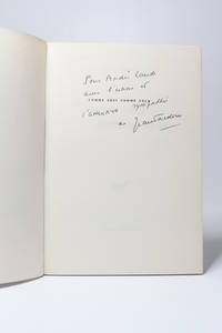
197972183Paris: Gallimard 1979. Fine. Gallimard Paris 1979 14 x 20.50 cm broché First edition a Service de Presse advance copy. Handsome copy. Signed and inscribed by Jean Tardieu to André Laude. Gallimard unknown
18201103020030Grave par P.F. Tardieu 1820. Map. Very Good. 5-1/4 x 18-1/2 inches. Copperplate engraving of Constantinople including labeled geographic features and key in top-right corner listing them. Pierre Francois Tardieu 1711-1774 was a prominent French cartographer and engraver working in the mid 18th century. This print provides a fine example of his cartographic work and attention to detail. Two small pinholes on middle left side of image border. Smudge marks on top-right corner of border. Image itself remains clear and detailed. Ink lines are crisp and clean. A superior chart in excellent condition. Grave par P.F. Tardieu unknown
1966287841966. S.l. Gallimard 1966. Un vol. au format in-8 carrÂŽ 195 x 173 mm de 81 pp. brochÂŽ sous couverture ˆ rabats rempliÂŽs. Edition originale ; rÂŽalisÂŽe d'aprÂs une maquette de Robert Massin. Un des exemplaires numÂŽrotÂŽs du tirage sur offset mat ivoire des Papeteries de Bellegarde ; seul papier. ''Les six voix de ce sextuor sont ici interprÂŽtÂŽes ˆ l'aide de six caractÂres typographiques diffÂŽrents. La page se prÂŽsente donc comme une partition d'orchestre tandis que le lecteur occupe en quelque sorte la place de chef d'orchestre.'' Massin L'ABC du mÂŽtier p. 159 reproduit - Wolff Massin p. 90 reproduit - Catalogue raisonnÂŽ de l'oeuvre typographique de Massin II p. 74 reproduit. TrÂs belle condition. b42961 unknown
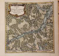
1762M9032Paris 1762. Very Good backed on acid free tissue paper for long term preservation left margin is extended. Notes: Fine and scarce French 18th century map of St. Lawrence River and Quebec. The course of the river to the East is from Montreal and passing through the Quebec City and it extends to Tadoussac. Size : 220x215 mm 8.66x8.46 Inches Coloring: Hand Colored Reference: Kershaw vol.II #659. Category: Maps Canada East Quebec; Maps Canada East Quebec St. Lawrence River; unknown
036426246X.Ghardcover. Good. Access codes and supplements are not guaranteed with used items. May be an ex-library book. hardcover
181053137Precis de la Geographie Universelle by Malte Brun. 1810. Clear and detailed engraving of Scandinavia with inset maps of Iceland and the Faroe Islands. Illustrated cartouche at lower right showing title on a rock in a forest. Two scales below Copper engraving. Fine condition Later colour. Size: 30 x 21 cm. 12 x 8½ inches unknown
59-3112Paris: Didot 1749. From Histoire des Voyages by Abbe Prevost. Vol. 5 no. 27. Image size is 14 x 20.2 cm 5-1/2 x 8 inches. Paris: Didot, 1749. unknown
0332707784.Ghardcover. Good. Access codes and supplements are not guaranteed with used items. May be an ex-library book. hardcover
ria9783030379575_inpPaperback. New. New Book; Fast Shipping from UK; Not signed; Not First Edition; The digital revolution is changing virtually every aspect of the business world. However most attempts at the digital transformation of enterprises fail - largely because of a lack of comprehensive and coherent strategy. This book take paperback
ria9783030379544_inpHardcover. New. New Book; Fast Shipping from UK; Not signed; Not First Edition; The digital revolution is changing virtually every aspect of the business world. However most attempts at the digital transformation of enterprises fail - largely because of a lack of comprehensive and coherent strategy. This book take hardcover
B9783030379575Paperback / softback. New. paperback
2020x-303037954XSpringer 2020. Hardcover. New. 342 pages. 9.25x6.10x0.94 inches. Springer hardcover