122 150 résultats
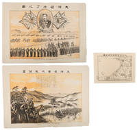
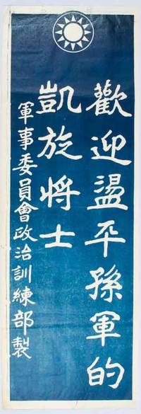
1926170205China.: 國民政府軍事委員會政治訓練部. Guo min zheng fu jun shi wei yuan hui zheng zhi xun lian bu. circa 1926-1928. Chinese Kuomintang propaganda poster screen print in blue. Issued by the Political Training Department of the Military Affairs Commission party emblem "Blue Sky with a White Sun" of the Kuomintang at upper edge text in Traditional Chinese. Some light creasing a little offsetting of ink at margins very good. Text in traditional Chinese. Sheet measures 78.6 x 27.3cm. The reference to Sun's Army in the title of this poster refers to the army of Chinese warlord 孙传芳 Sun Chuanfang whose strong military presence was felt in Zhejiang Jiangsu Anhui Fujian and Jiangxi in the years between 1922 and 1926. Sun together with other major warlords 冯国璋 Feng Guozhang 曹锟 Cao Kun 吴佩孚 Wu Peifu and 齐燮元 Qi Xieyuan were part of the Zhili Clique. Sun had been Chiang Kai-shek’s second military target when the National Revolutionary Army NRA took over Hunan from Wu Peifu’s control. The official confrontation between the NRA and Sun's army began in August 1926 in Jiangxi Province later another battlefield opened between them in Fujian Province in September of the same year. The wars between Sun's Army and NRA lasted until April 1928 when Sun faced complete defeat. <br> <br>The text on this poster reads "Welcome the Returning Triumphant Troops Who Crushed Sun's Army." The text suggests that the poster was probably issued after Sun's defeat in 1928. However 國民政府軍事委員會政治訓練部 "Political Training Department Military Affairs Commission of the Nationalist Government" only existed for only three months between March - June 1926. Possible explanations for the contradictory dates are that the slogans were published prior to the defeat in an effort to wish military success against Sun; or possibly given the chaotic situation in China at the time the publication details were not updated to reflect the new agency in charge. . 國民政府軍事委員會政治訓練部. [Guo min zheng unknown
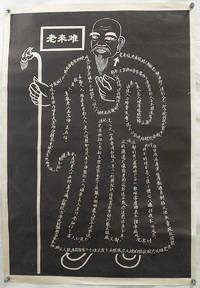
1980223104Unknown.: No publication details. circa1980. A poster with the image of an old man Lao Lai Zi outlined with white characters on a black background text in simplified Chinese characters 77 x 52.5cm small 1cm closed tear right edge and lower left corner repaired. In good condition with clear and well defined characters making the text easy to read. Lao Lai Zi a symbol of aging and filial piety is here represented in what appears to be a white line drawing on a black background. On closer inspection however the lines are made up of poignant and occasionally amusing rhyming verses listing the indignities of old age imploring the young not to look down on the elderly. <br> <br>The original stele carved with a similar image titled “Lao Lai Nan” Growing Old is Hard is located at the Temple of the Medicine King in Beipo village in Shaanxi Province. It isn’t known exactly when the Beipo stele was carved but it is said to be related to a Mrs Li who lived in the temple and wanted it carved to teach her unfilial children a lesson. The use of simplified characters and catchy verse written in modern Chinese indicate that it is a 20th century artefact. The Beipo stele includes smaller carvings of eight old people using sticks along the vertical edges. <br> <br>This poster is a modern artistic stone rubbing interpretation of the main visual feature on the Beipo stele i.e. the central figure outlined in characters in a pose and design similar to the original. A well known educational Chinese folk illustration “Lao Lai Nan” is a moral lesson on respect for the elderly. <br> <br>老来难, 老来难,劝人别把老人嫌, 当初嫌别人老,如今轮到我头前,千般苦, 万般难,听我从头说一番。耳聋难与人说话, 差七差八惹人嫌. … <br> <br>Getting old is hard it’s hard I urge you not to look down on the elderly. Earlier I despised others for being old but now that I’m facing it head on with a thousand kinds of troubles and difficulties listen to everything I say. <br>Being hard of hearing makes it difficult to communicate if you miss this or that you annoy people… <br> <br>… …痛苦难言聆,明不明睡不着, 一夜小便七八遍,怕夜长, 怕风寒, 时常受风病来缠 年老肺虚常咳嗽, 一口一口吐粘痰,儿女们都恨咱说,我邋遢不像前,老的这样还不死,你还想活多少年… … <br> <br>… It’s hard to explain all the difficulties one can’t sleep and every night one gets up to urinate seven or eight times. I hate long nights cold breezes and I get sick from being in draughts. My lungs are weak and I cough and cough and cough up phlegm so my children dislike talking to me. They seem to think I’m unkempt and don’t look like my former self. So old and still not dead how much longer am I planning to live . No publication details. unknown
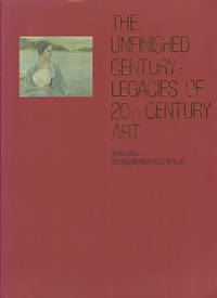
2002163952The National Museum of Modern Art Tokyo. 2002. Colour plates throughout 279pp. Very good copy in paperback. 30.3 cm x 22.7 cm A catalog of an art exhibition held at the National Museum of Modern Art Tokyo from 16th January to 10th March 2002. In commemoration of the museum's renewal 390 works of art by Japanese and overseas artists - paintings sculptures prints photographs and crafts - were exhibited. . [The National Museum of Modern Art, Tokyo]. paperback
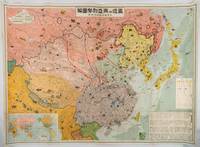
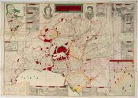
1937194318大阪. Osaka.: 大阪毎日新聞社. Osaka Mainichi Shimbunsha. Showa 12 1937. Large colourful folding map of East Asia measuring 79 x 109cm. Small holes at folding points and closed tears on the verso now neatly repaired with Japanese washi. Some light general wear but overall a bright and clean copy of this interesting map. Published in late 1937 this colourful pictorial map shows the dynamic military situation in East Asia from the Japanese point of view. Showing somewhat inaccurate information with incomplete conclusions this map provides a better understanding of why Japan made the ill-informed decision to escalate its invasion of China following the Marco Polo Bridge incident. The area covered includes Japan Taiwan China and the Soviet Union and attempts to show tensions along real and imagined zones of control. Information about Soviet and Chinese military power is also included on the map. <br> <br>These propaganda maps conveyed the extent of the Japanese government's ambition to the Japanese population with the charming cartoon-style images of wildlife and other natural resources industries and historical landmarks indicating the anticipated gains of Japanese foreign policy. Interestingly positions of military forces transport routes defence structures and radio transmission stations are also marked on the map though many of these appear phantasmic and out of step with reality. An inset world map at lower left shows the area within a global context. <br> <br>Offering a glimpse into the incomplete information at the hands of the Japanese authorities and perhaps in part understood by the mapmakers in the context of Chinese Communist and Soviet successes in Yan'an and Xinjiang large sections of Qinghai Gansu and Ningxia are marked as under Soviet influence. At this stage this region was largely under the control of Kuomintang-aligned warlords and although the region was implicitly threatened by underground Communist insurgents so too was the rest of China. The focussed attention given to Communist influence and China's internal political divisions is indicative of the failure of Japanese planners to anticipate the cooperation of Communist and Nationalist forces in the face of Japanese aggression. <br> <br>The text box at right translated reads "Current State of Affairs in East Asia." In the legend the coloured boxes indicate the following areas: reading right to left: <br>Dark yellow: Japan <br>Pale yellow: Manchukuo <br>Red: Soviet Union Russia <br>Pink: Sovietised area <br>Purple: Republic of China China <br>Grey: China North China Buffer State where a special relationship with Japan is emerging <br>Green: East Hebei Autonomous Government . 大阪毎日新聞社. [Osaka Mainichi Shimbunsha]. unknown
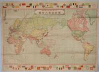
1931216820東京. Tokyo.: 大日本雄弁会講談社. Dainihon Yūbenkai Kōdansha. Showa 6 1931. Large colour folding map of the world with attractive border of some curiously chosen merchant ensigns and coats of arms along the upper and lower margins 78 x 110 cm. Neat repairs along some folds on reverse a little toning on map but still a good attractive copy. This large map of the world was issued as the new year supplement for a boys' magazine Shonen Kurabu 少年倶楽部 in January 1931. Japan and its territories in red are positioned in the centre of the map. The vastness of Russia and the British Empire stand out and the Irish Free State is still indicated as being part of the UK. Interestingly Russia is still shown in its customary Imperial green rather than the more common red that was typically adopted for the Soviet Union. . 大日本雄弁会講談社. [Dainihon Yūbenkai Kōdansha]. unknown
1898218770大阪. Osaka.: 山口新三. Yamaguchi Shinzo. Meiji 31 1898. Black and white map 20 x 27cm together with two colour photolithographic prints each with a light vertical central crease 39.2 x 54.5cm. Very good. This collection consists of three items — two colour prints and a map—related to the Army Training Exercise held in Osaka in 1898. They are titled: <br> <br>Daienshū jicchi sentōga 大演習実地戦闘画 <br>Daienshū shūryō no zu 大演習終了之図 and <br>Daienshū sentōga furoku chizu 大演習戦闘画附録地図. <br> <br>The Emperor attended the exercise in person an event that was regarded as a great honour for the local residents. The two prints depict scenes from the exercise — one showing the Emperor on horseback observing an attack and the other capturing the final parade. The supplementary map covers Osaka and its southern outskirts where the manoeuvres took place. . 山口新三. Yamaguchi, Shinzo. unknown
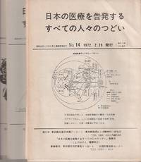
1972214333東京. Tokyo.: 日本の医療を告発するすべての人々のつどい事務局. Nihon no Iryō o kokuhatsu suru subete no hitobito no tsudoi Jimukyoku. 1972- 1974. Periodical 18 issues: Nos.14 15 18 19 20 21 22/23 25 26 27 28/29 30 31 33 34 35/36 37 43 charts diagrams graphs approximately 20pp per issue 25 x 17cm orginal wrappers. Occasional browning overall very good. This compelling periodical collection Nihon no iryō o kokuhatsu suru subete no hitobito no tsudoi highlights significant issues related to healthcare services and medical practices in Japan during the 1970s. At that time while Japan experienced rapid economic growth serious problems in the health sector were emerging such as air pollution illnesses caused by medication and cases of medical negligence. However openly addressing these issues was difficult due to internal pressures. Contributors to the journal were health industry professionals aiming to inform the broader public about the realities within the sector. The topics covered are diverse but remain crucial for both healthcare practitioners and consumers. The periodical's publisher was based at the Department of Psychiatry at Tokyo University a focal point of the 1960s student movement. . 日本の医療を告発するすべての人々 unknown
1972157270文物出版社.Wen wu chu ban she. 1st Edition 1st Printing. 1972. Tipped in colour plates photographic illustrations in black and white 152pp hardback in cloth protected by plastic cover as issued housed in its original slipcase booklet in Chinese with notes for each cultural relic and a brief introduction of the development of archaeology work during the Chinese Cultural Revolution loosely inserted. 36 x 27cm. The cultural relics showed in this book were discovered in many regions of China during Cultural Revolution with a wide range such as ceramics lacquerware costume bronzes. The discovery is very much important in the modern Chinese archaeology history. . 文物出版社.[Wen wu chu ban she]. hardcover
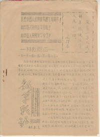
1967172500上海.Shanghai.: 上海交通大学反到底兵团.Shanghai jiao tong da xue fan dao di bing tuan. 上海交大教育革命联络站.Shanghai jiao tong da xue ge ming jiao yu lian luo zhan. 1967. 4pp Chinese Cultural Revolution newspaper jointly issued by the "Fight to the End" Corp and Education Revolution Liaison Station Shanghai Jiao Tong University. A quotation from Chairman Mao is accompanied by three lines of propaganda slogans on the first page. This paper features Lin Biao and Chen Boda's directives on education reforms on the first two pages. Light even browning little stained at staples light wear generally good. Text in Chinese. 24.8 x 18.1cm. . 上海交通大学反到底兵团.[Shanghai jiao tong da xue fan dao di b unknown
1719176771東京. Tokyo.: 日本放送出版会社. Nihon Hōsō Shuppan Kaisha. Showa 17 1942. Colour folding map scale 1:14500000 55cm x 80cm naval warship photographic illustrations on reverse. The wartime paper is browned and friable but small closed tears along fold lines and edges have been neatly repaired with archival washi on the verso. 79 x 53cm This colour map of Asia and the Pacific was published as a supplement to a magazine Hoso 放送 on January 1942 less than one month after the Pearl Harbor attack by the Japanese Forces. The war had just started but amazingly the map accurately predicted where the fighting would take place throughout the war. An inset map on upper right shows Singapore Borneo Sumatra and Java where battles took place in the area in early 1942. An inset chart on lower left shows various resources and their location including coal tin and iron ore clearly showing that the war was fought over securing resources. On reverse eleven photographic illustrations of war ships from Germany Britain the US and Japan are shown including the Prince of Wales and Enterprise. . 日本放送出版会社. [Nihon Hōsō Shuppan Kaisha]. unknown
1892196563山中善三郎. Yamanaka Zenzaburo. Meiji 25 1892. Colour woodblock folding map of Tokyo with inset city plan of Yokohama a plan of the Diet a chart with many town names and a selection of images of sites. 51 x 71.5cm folds into 18.2 x 12cm paper covered covers paper title label on upper cover has some insect damage and fading wear at fold points with some tiny holes now neatly secured on the reverse with washi. The 1892 map of Tokyo provides an intricate view of the central and surrounding areas of the Tokyo metropolitan region. The map's focal point is the Royal Palace distinguished by its vivid red hue. Alongside this select military facilities also stand out in red. The map's legends unveil sections of Meiji Tokyo. Aristocrats' residences police stations and telegraph stations are marked reflecting the city's diverse functions. Shrines and temple are also indicated. Interestingly the map presents portraits of Emperor Meiji attired in Western clothing and Empress Meiji adorned in traditional kimono. These depictions flank the map's title. Accentuating the map's narrative are sixteen illustrations thoughtfully dispersed around the periphery showcasing Tokyo's key landmarks and significant structures. . 山中善三郎. [Yamanaka Zenzaburo]. hardcover
2008169215北京.Beijing.: 星球地图出版社.Xing qiu di tu chu ban she. May2008. Two large coloured maps printed on double sided on a single sheet folded issued shortly after the devastating 2008 Wenchuan Earthquake which was occurred on 12 May 2008. Small tears along folds mended by both non-acidic tape and cello tape some creasing generally good. Text in Chinese. Sheet measures 84.9 x 119.7cm. <br> <br>Map of Sichuan Province: scale 1: 1100000 inset map lower right corner showing the provincial capital city Chengdu a statistical chart lower section listing counties within Sichuan Province their population and territory size. <br> <br>Map of Wenchuan County and Its Vicinity: 1: 300000 various colour representing altitude differences inset map showing the position Wenchuan County within Sichuan Province a mileage chart listing the distance between Wenchuan County to nearby cities. A brief introduction of Wenchuan on left section accompanying the images of the rescue forces. The Great Wenchuan Earthquake was the biggest earthquake in Chinese history with a casualty over 69000 people. . 星球地图出版社.[Xing qiu di tu chu ban she]. unknown
1950215749Northeast China People's Press. Late1950s. Army distributed notebook with pictorial endpapers 24pp of inspirational text map of the Korean campaign with printed annotated and some captioned black and white photographic illustrations. Final 8 pages contain a month by month printed summary of the Korean campaign 1950 - 51. However the diary entries are dated 1959 and 1960 and are unrelated to the Korean campaign. Entries are written in cursive Chinese script. Pages and endpapers foxed and browned upper hinge split edges thumbed cover worn and upper right corner creased. Heavy signs of use but still sound. 16.6 x 11.5cm. . Northeast China People's Press. unknown
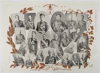
1906218805東京. Tokyo.: 東京日日新聞. Tokyo Nichinichi Shinbun. Meiji 39 1906. Black and white photographic illustrations 39.5 x 54.3cm light creasing where it has been folded very good. This collection of photographic portraits was published by Tokyo Nichinichi Newspaper on 1 January 1906 to commemorate the victory over Russia in the Russo-Japanese War. It features Meiji Emperor and his aristocratic members as well as major military commanders including Admiral Togo General Oyama and General Nogi. . 東京日日新聞. [Tokyo Nichinichi Shinbun]. unknown
1905217437Guangdong.: 廣東省香山縣梅溪鄉陳門容氏敬刊. 1905. Buddhist philosophical text ii 53 folded pages woodblock print from the Guangxu era. Browned throughout upper corners worn with loss some washi repairs original wrappers worn and torn with considerable loss to upper cover. Upper wrapper torn with loss however title page and Chinese four-hole stab binding is intact. Slight bleeding of wrapper colour onto the first few pages only. Text complete. 21.8 x 13.2cm. . 廣東省香山縣梅溪鄉陳門容氏敬刊. unknown
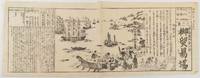
1859177810Japan. Ansei 6 1859. Black and white woodblock kawaraban published in two joined sheets 35 x 70cm. Washi repair on reverse close to join occasional small holes at edges a little thinning in places but overall very good. This foreign trade kawaraban was published in January 1859 soon after the Ansei Treaties were finalised between Japan and five Western countries the USA Britain France Holland and Russia. The text explains how the treaties operate with the countries and which lords are responsible for trading activities. The illustration shows numerous foreign ships off the shore with their sails and flags. Many foreign sailors Russian are depicted unloading curios and trading goods from rowing boats onto a harbour in Yokohama. Some vases elephant tasks and other objects are brought to the shore while three Japanese officials are watching. The artist's detailed observation of this lively scene is clearly demonstrated in this fine illustration. . unknown
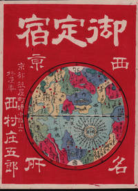
1878214047京都. Kyoto.: 西村庄五郎. Nishimura Shōgorou. 1878. Stunning colour map woodblock advertisement 25 x 19cm very good condition. This unusual and advertising woodblock map/print promotes Hiiragiya a renowned Japanese inn located in Kyoto. The print depicts the inn as the focal point of a Kyoto map humorously mimicking a world map. Established in 1861 by Nishimura Shogoro Hiiragiya continues to operate as a prestigious five-star inn in the heart of Kyoto. <br> <br>In the map distances to various landmarks and sites are indicated around the inn showcasing its central location within Kyoto. Additionally illustrations of major attractions such as the Royal Palace and the Kyoto Prefectural Office are depicted alongside the inn highlighting its proximity to key destinations. <br> <br>This eye-catching print serves as both an advertisement for Hiiragiya and a whimsical representation of Kyoto's attractions emphasizing the inn's prime location and prestigious reputation in the city. . 西村庄五郎. [Nishimura, Shōgorou]. unknown
1984220506Beijing.: 中華書局 Zhonghua shuju. 1984. Complete in three volumes Volume I 803pp; Volume II 805 - 1704; Volume III 1705 - 2502pp text in traditional Chinese characters 21 x 14.5cm hardback bound in embossed blue cloth with gilt lettering. Foxing with some discolouration to first and last pages and edges very good hardback copy. This official Qing dynasty chronicle documents Emperor Kangxi’s daily activities court discussions and imperial decrees. Compiled by court historians it includes political decisions governance diplomacy personal reflections interactions with officials and Kangxi's role in consolidating power . A key primary source for Kangxi’s 61-year reign. . 中華書局 [Zhonghua shuju]. hardcover
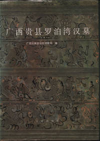
1988219801Beijing.: 文物出版社. Wenwu chubanshe. 1988. Map colour and black and white photographic illustrations black line drawings and tomb diagrams 147 12 64pp. Text in simplified Chinese characters with abstract in English 26.5 x 19cm hardback. Light occasional foxing first and last pages cover and dustjacket a little worn and trifle sunned. A good copy. This book refers to a Western Han Dynasty tomb in Guangxi known for its well-preserved artifacts including bronze drums lacquerware and silk. The findings reflect cultural exchanges between the Han Chinese and local Baiyue peoples showcasing early southern China's prosperity. . 文物出版社. [Wenwu chubanshe]. hardcover
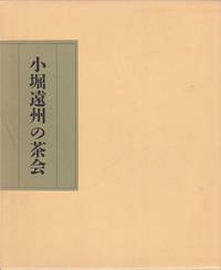
1996221360Tokyo.: Two Volumes on Japanese Teaware. 1996. Two volumes. Volume I Kobori Enshu no chakai: 113pp chronology. Volume II Enshu no mita chajin: 219pp. Both volumes: Colour and monochrome photographic plates. 26 x 21.3cm. Text in Japanese. A very good paperback set in original cardboard slipcase. From the library of Aubrey and Eva Sweet with a small label indicating the collection number on the slipcase spine. . Two Volumes on Japanese Teaware. paperback
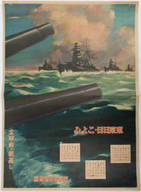
1619176888東京. Tokyo.: 東京日日新聞社. Tōkyō Nichinichi Shinbunsha. Showa 16 1941. Colour poster from a 1941 calendar. 53.5 x 38.5cm small holes at corners central horizontal fold. Some light even browning but overall a striking WWII image from a Japanese calendar. This colour illustrated calendar shows the months of March April and May 1941. The illustration features four Japanese war ships at sea with two naval guns in the foreground. The calendar is titled "Rough Sea on the Pacific Ocean". The implication being military threats are coming from across the Pacific. . 東京日日新聞社. [Tōkyō Nichinichi Shinbunsha]. unknown
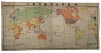
1719218447Japan.: 大本營海軍報道部 Daihonei Kaigun Hōdōbu. Showa 17 1942. Large colour folding map 165 x 215.8cm. Some strengthening of folds and neat repairs on reverse small chip in margin a little light browning on some folds but overall very good. This extra-large world map presents a detailed depiction of global wartime activity during the latter half of 1942. Japanese military campaigns and land and sea battles that occurred between 10 April and the end of September are marked in red with all naval engagements included. The map highlights the growing intensity of conflict in Southeast Asia and the Pacific areas that appear to have reached the height of military activity at the time of publication. In Europe regions under German and Italian control are indicated with blue diagonal lines. A comprehensive legend identifies military air and submarine bases belonging to Germany Italy and the Allied nations as well as territories occupied or bombed by Japanese forces. . 大本營海軍報道部 [Daihonei Kaigun Hōdōbu]. unknown
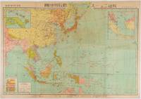
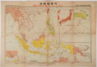
1719219230東京. Tokyo.: 日本放送協会. Nihon Hōsō Shuppan Kyōkai. Showa 17 1942. Colour folding map scale 1: 10000000 54.7cm x 79.5cm chronology of building the Greater East Asia Co-Prosperity Sphere on reverse. Some light browning a little darker at folds and reverse washi repairs to folds on reverse. This colour map of Asia and the Pacific published on 30 January 1942—just one month after Japan's attack on Pearl Harbor—offers a striking glimpse into wartime strategy and propaganda. Remarkably despite being produced at the war's outset it accurately anticipated key battlegrounds that would define the conflict. The main map is supplemented by two inset maps: one in the upper right highlighting Japan the Hawaiian Islands and Honolulu and another in the lower left focusing on Singapore with Darwin marked along the lower edge. <br> <br>The reverse side features a revealing chronological chart titled "Building Great East Asia" documenting Japan's military expansion from the 1931 Manchurian Incident through January 1942 as troops advanced across Southeast Asia. Notably two blank rows were intentionally left at the chart's end anticipating future victories to be recorded as the war progressed—a telling detail that underscores the map's dual role as both strategic document and propaganda tool. An interesting map which combines geographical precision with ideological messaging. . 日本放送協会. [Nihon Hōsō Shuppan Kyōkai]. unknown
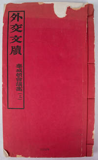
1923170115Peking.: 外交部. Wai jiao bu. December1923. Volume One only of three. 4 108 leaves four-hole stab binding in red paper covers. Original red wrappers a little faded in places and chipped and torn with some loss. Title pages some occasional foxing but generally very clean small numeric stamp upper wrapper barely visible light damp stain outer edge last leaves 4 x 3cm loss to paper on title page not affecting the text very clean and sound internally. Text in traditional Chinese. 32.6 x 19.2cm. Scarce. This conference also known as The Washington Naval Conference; The Washington Arms Conference or the Washington Disarmament Conference was a meeting of delegates from nine nations - the USA Japan China France Britain Italy Belgium the Netherlands and Portugal. This group which very deliberately excluded Russia met in this interesting post WWI world to discuss and negotiate their interests in the Pacific and the East Asian region. Three major treaties were some of the results of the conference: Four-Power Treaty; Five-Power Treaty also known at the Washington Naval Treaty and the Nine-Power Treaty together with a number of other smaller agreements. These treaties helped keep the peace throughout the 1920s and also helped Japan build up her navy and work on consolidating her position in China. The decisions and actions that took place at this conference clearly had an effect on the lead up to World War II in East Asia and it can be argued still have echoes today on relationships with and within the region today. . 外交部. [Wai jiao bu]. unknown
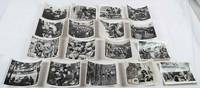
1966217773News Exhibition Photos of Xinhua Publishing. 1966. Set of 17 of 20 black and white numbered photographs of study groups workers peasants and soldiers in various locations missing numbers 6 9 and 15 11.5 x 15cm. Library stamp on reverse offset in small area onto three images photographs presented in envelope label laid down on the front providing publication and sales details such as price number and date. The whole presented in a Xinhua plastic envelope. Among the many interesting photographs in this group is an image of a cave hospital in what appears to be a Hui minority group area with food drying and people waiting on a bench outside and an image of people crossing a river with bundles tied to carrying poles. <br> <br>While this group of photographs is incomplete the inclusion of the envelope with production and sales details is unusual and provides valuable information not commonly found with such sets of photographs. . News Exhibition Photos of Xinhua Publishing. unknown