Smith, Calvin LBiblio.com
8 407 résultats
9004156453.Gpaperback. Good. Access codes and supplements are not guaranteed with used items. May be an ex-library book. paperback
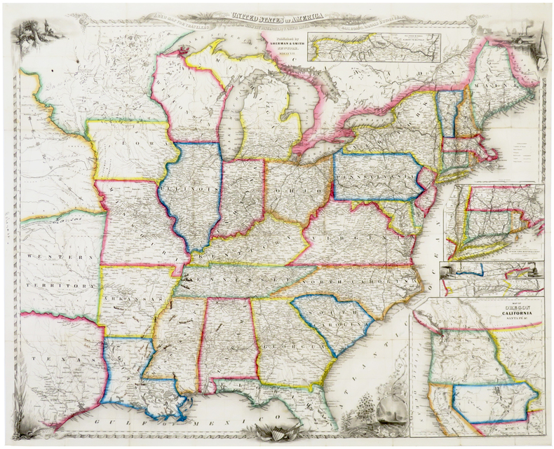
185059668New York:: Sherman & Smith 1850. . in publisher's gilt-lettered cloth portfolio as issued. A few neat tissue repairs on verso to tiny splits at fold intersections; a beautiful copy. 22 x 27 inches folded to 12mo. Folding map with original outline color; inset maps of Boston and New York environs; and engraved vignettes of Niagara Falls Notch of White Mountains Falls of Montmorenci and View of Mount Holyoke Mass. . Sherman & Smith, hardcover
1015902359.Ghardcover. Good. Access codes and supplements are not guaranteed with used items. May be an ex-library book. hardcover
1849r3543New York: Sherman & Smith. G : in Good condition. Cover lightly rubbed soiled and bumped. Slight darkening to page ends. Stamps of previous owner on fep and base of title page. Pencil annotation on ffep. Rear fold out map G with small tear at fore edge of centre fold. Contents tight. 1849. Reprint. Red/gilt hardback cloth cover. 150mm x 90mm 6" x 4". 234pp. 125 highly finished engravings and a large and accurate map hand coloured in outline. Containing a description of the states cities towns villages watering places colleges etc.etc.; with the railroad stage and steamboat routes the distance from place to place and the fares on the great travelling routes. . Sherman & Smith hardcover
0938626566.Ghardcover. Good. Access codes and supplements are not guaranteed with used items. May be an ex-library book. hardcover
1852LBW-6388New York, Sherman & Smith, 1852. 550 x 685 mm, sur papier fin.
1847106023<p>16mo original brown cloth decoratively stamped in gilt and blind illustrated with 125 engravings 233 pp. and folding map 52 x 67 cm 20 1/2" x 26 1/4" plus decorative border. Minor fading and wear to covers some pencil notes on endpapers about a 6" split at one fold a smaller split at another fold otherwise a really nice map; overall very good or better. Smith was a prominent mapmaker in the mid 19th century. He competed with the likes of Colton and Mitchell and was associated with John Disturnell back in the 1840s.He published a number of city maps around that time. In 1843 Smith published a large map of the United States and three years later in 1846 he published the first edition of this map. Considered a really good map it basically covers the eastern and midwestern part of the U.S. California and Oregon are featured in an inset and part of Texas is also shown. Some railroad and canal routs in the northeast are also highlighted. Ristow: American Maps. </p> Sherman & Smith, books
1848106024<p>16mo original red cloth decoratively stamped in gilt and blind illustrated with 125 engravings 234 pp. and folding map 52 x 67 cm 20 1/2" x 26 1/4" plus decorative border. Old ink name on front pastedown with catalogue entry glued in some light foxing within map slightly darkened a few short splits at folds; otherwise very good. Smith was a prominent mapmaker in the mid 19th century. He competed with the likes of Colton and Mitchell and was associated with John Disturnell back in the 1840s.He published a number of city maps around that time. In 1843 Smith published a large map of the United States and three years later in 1846 he published the first edition of this map. Considered a really good map it basically covers the eastern and midwestern part of the U.S. California and Oregon are featured in an inset and part of Texas is also shown. Some railroad and canal routs in the northeast are also highlighted. Ristow: American Maps. </p> Sherman & Smith, books
1849216749New York: Sherman & Smith 122 Broadway 1849. Illustrated with 125 engravings in the text. Large folding map by Smith 22 x 25 3/4 inches at the back outlined in period color "A New Map for Travellers throught the United States" New York Sherman & Smith 1849". 2 ads 234 pp. 1 vols. 12mo. Original green gilt-stamped cloth with slight wear at extremities. One piece missing from right edge of map approximately 3 x 3 inches affecting one inset. Illustrated with 125 engravings in the text. Large folding map by Smith 22 x 25 3/4 inches at the back outlined in period color "A New Map for Travellers throught the United States" New York Sherman & Smith 1849". 2 ads 234 pp. 1 vols. 12mo. An important map of the U.S. first published in the 1846 edition which was updated for the editions of 1848 1849 this and 1850 then published separately in 1853 and 1853. With five insets to the general map: "Railroad & Canal Routes from Albany to Buffalo" "Map Showing the Rail Roads between the Cities of New York Boston & Albany" mostly missing in this copy "Railroad Route from New York to Philadelphia" "Railroad Route from Philadelphia to Washington" and "Map of Oregon Northern California Santa Fe &c." The latter inset first published in the 1846 edition although small is important for showing regions before the Mexican War and was copied by other map makers. Howes S 614; Sabin 82928; Wheat 56 ref Sherman & Smith, 122 Broadway unknown books
185238236New York: J.H. Colton 1852. 16mo pp. 89 18 ads; large folding hand-colored map of the region approx. 21" x 26"; map a little spotted and with several minor marginal tears and breaks otherwise the map is generally in fine condition; original green cloth gilt stamped on upper cover extremities rubbed; all else very good. An edition unnoticed by Howes but see Howes S615 for a number of others. <br/><br/> J.H. Colton hardcover books
185419316New York: J.H. Colton & Co 1854. 16mo pp. 89 23 4; large folding hand-colored map of the region approx. 21" x 26"; one short split at one fold otherwise the map is generally in fine condition; original red cloth gilt stamped on upper cover extremities rubbed and the binding slightly stained front free flyleaf excised old pencil notes on rear flyleaf in German; pretty good copy. Howes S615. <br/><br/> J.H. Colton & Co hardcover books
185335524NY: J.H. Colton 1853. 12mo. 89 pp. 24-page Colton catalogue of "maps charts books etc." Map: GUIDE THROUGH OHIO MICHIGAN INDIANA ILLINOIS MISSOURI WISCONSIN & IOWA SHOWING THE TOWNSHIP LINES OF THE UNITED STATES SURVEYS; LOCATION OF CITIES TOWNS VILLAGES POST HAMLETS CANALS RAIL AND STAGE ROADS by J. Calvin Smith; hand-colored broadside with ornamental border 22 x 26 1/2 inches folded to 12mo. Original elaborately gilt-stamped illustrated cloth a little rubbed; some foxing but the map fine. Reprint of a revised edition. Howes S-615. <br/><br/> J.H. Colton hardcover books
1847Embry 82690Sherman & Smith 1847. Second edition. Some mild toning to map occasional light foxing throughout rather elaborate ownership markings to front free endpaper expertly rebacked with original spine laid down overall a nicely restored copy with the map in excellent condition. One hundred twenty five text engravings and large folding map with colored outlines. Brown cloth decoratively stamped in gilt and blind. Map dated 1847. Howes S 614. Sherman & Smith, 1847. Second edition. hardcover books
18508913New York 1850. Hardcover. Very Good. 21 ¾ x 26 inches. Lithograph with original hand color; some fold reinforcements with some mended losses at intersections very good condition. A delicately beautiful map of mid-19th century United States with extensive transportation-related content. Four of the work's five inset maps focus on rail lines and canals in specific parts of the country. The large inset of the western United States at bottom right completes the picture of the country that is not shown in the main map. Thus all of Texas is shown on the map and the California Territory is depicted as stretching as far east as the Texas border. The map generally is very well detailed and shows stage roads in addition to railroads and canals. It has a beautifully rendered floral border in which are fine scenic vistas including of Niagara Falls and a harbor scene with ship that is powered by both steam and sail. Published in A New Guide for Travelers.80 pp excellent in original binding included but separate. Modelski Railroad Maps no. 8. hardcover books
1849WRCAM54260New York: Sherman & Smith 1849. Folding map approximately 22 x 19 3/4 inches partially handcolored. 24mo. Original publisher's cloth stamped in blind and gold lettered. Very light wear to cloth. 20th-century bookplate on front pastedown. A near mint copy of this map in remarkable fine condition. In a half pebbled cloth and printed paper board clamshell box. A rare early version of Smith's MAP OF NORTH AMERICA with an inset of California with the gold regions highlighted. Another edition was published the same year by John Disturnell and it was reissued the following year to accompany the third edition of Disturnell's EMIGRANT'S GUIDE. The routes to California and Oregon from Independence Fort Smith and Port Lavaca are indicated in red and the gold regions of California are shaded yellow. OCLC records only two copies of this edition at Berkeley and UC Davis and Wheat notes one further at the California State Library. WHEAT GOLD REGION 124. WHEAT TRANSMISSISSIPPI 643. HOWES D351 ref. KURUTZ 196 ref. Sherman & Smith hardcover books
1848WRCAM32759New York: Published by J. Disturnell 1848. Folding pocket map 19 x 23 1/2 inches engraved on steel by Sherman & Smith with full period color. Bound into original 16mo. brown cloth boards stamped in blind and gilt. Very good. This is a finely engraved and detailed general map of the State of New York with two insets: "The St. Lawrence River from the New York State line to Quebec" and "City of New York with Part of Brooklyn and Williamsburgh." Canals are shown in blue and railroads in orange. Not in Rumsey. PHILLIPS MAPS p.513. Published by J. Disturnell hardcover books
1848011489New York: Sherman & Smith. Good. 1848. Hardcover. An early guide to travel in the United States missing the map. Brown blind embossed cloth boards with gilt imprint. Light rubbing of board faces and corners. Adhesive mark on rear pastedown where map was tipped in. Foxed pages with dampstained corners and a few tears on first pages. The tables give mileages and routes for everywhere you'd want to go in the United States including from St. Louis Missouri to Astoria Oregon or the newly acquired Santa Fe. ; 5 3/4" x 3 3/4"; 79 pp . Sherman & Smith hardcover books
1852WRCAM54266Cassel: Theodor Fischer 1852. Sixteen color lithographed mapsheets each 15 1/2 x 19 3/4 inches plus 2pp. explanatory text. Large oblong folio. Original printed paper- covered boards cloth backstrip. Minor rubbing and edge wear light staining. Internally clean. Very good plus. A rare and unusual atlas for the eastern half of the United States printed in German by noted American mapmaker J. Calvin Smith. Fifteen of the sixteen mapsheets comprise a sectional map intended to be pieced together to create a very large map of the eastern United States extending westward to parts of Texas the Indian Territory later Oklahoma and Nebraska. The sixteenth mapsheet is a general map of the United States including a good portion of lower Canada and the Caribbean extending southward to Venezuela. The sheet of explanatory text pictures the sectional map if assembled correctly from the fifteen sheets. <br> <br> This atlas was issued during a period of great German emigration to the United States and it was clearly intended for the use of emigrants and emigration offices - it would have been of great use to them. <br> <br> Most of the time Smith's maps are encountered as American productions. Considering the flood of German emigration to the United States in the mid-19th century it is logical that this map was printed to encourage the practice and therefore commissioned by German investors in the United States. This German edition of Smith's map is rarer than his American productions with Colton. KARROW I:1626. KARPINSKI 177 dating it 1850. RUMSEY 3471 ref. Theodor Fischer hardcover books
R9798888901359Haymarket Books. New. Special order item direct from the distributor Haymarket Books unknown
2023x-0520385985Univ of California Pr 2023. Hardcover. New. 223 pages. 9.00x6.00x0.75 inches. Univ of California Pr hardcover
44871035-nnew. unknown
44871035like new. unknown
0520385993.Gpaperback. Good. Access codes and supplements are not guaranteed with used items. May be an ex-library book. paperback
0520385985.Ghardcover. Good. Access codes and supplements are not guaranteed with used items. May be an ex-library book. hardcover
2023x-0520385993Univ of California Pr 2023. Paperback. New. 223 pages. 8.75x5.75x0.75 inches. Univ of California Pr paperback