Ortelius, AbrahamBiblio.com
213 résultats
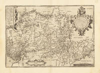
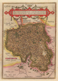
158410309Antwerpen: Platin 1584. In sehr gutem Erhaltungszustand. 31.3 x 223 cm 12.25 x 875 inches. Hand-Colored Original Copperplate Engraving by Abraham Ortelius depicting Waldeccensis Comitatus Descriptio Accuratissima. Published Antwerpen Platin 1584. Sheet: 31.3 x 223 cm 12.25 x 875 inches. A fine and original hand-colored example of Ortelius's celebrated cartographic work documenting this region of Germany with the precision and decorative artistry characteristic of the 15800s. Abraham Ortelius 1527-1598 was a Flemish cartographer and geographer from Antwerp widely regarded as the creator of the first modern atlas. His landmark publication Theatrum Orbis Terrarum 1570 set the standard for atlas-making for the next century presenting uniform copper-engraved maps with scholarly commentary. By Ortelius's death the Theatrum had appeared in 25 editions in seven languages. In 1575 King Philip II of Spain appointed him Royal Geographer. His maps engraved with extraordinary precision are among the most sought-after in antique cartography held in collections including the Plantin-Moretus Museum in Antwerp the Library of Congress and the British Library.This original copperplate engraving with original hand coloring depicts the region of Waldeccensis Comitatus Descriptio Accuratissima published in Antwerpen Platin 1584. The map records the political and geographic boundaries of the region as understood in 1584 offering a fascinating window into the history of German territorial organization. Sheet measures 31.3 x 223 cm 12.25 x 875 inches. Professionally restored; the image area is fully intact and displays well. Retains its original contemporary hand coloring. Ready to frame. Broe. 98 b; Koeman Ort. 21; Platin unknown
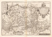
158433639Antwerpen 1584. In sehr gutem Zustand. 34.5 x 497 cm 13.5 x 195 inches. Hand-Colored Original Copperplate Engraving by Abraham Ortelius depicting Westphaliae Totius Finitimarumque Regionum Accurata Descriptio. Published Antwerpen 1584. Sheet: 34.5 x 497 cm 13.5 x 195 inches. A fine and original hand-colored example of Ortelius's celebrated cartographic work documenting this region of Germany with the precision and decorative artistry characteristic of the 15800s. Abraham Ortelius 1527-1598 was a Flemish cartographer and geographer from Antwerp widely regarded as the creator of the first modern atlas. His landmark publication Theatrum Orbis Terrarum 1570 set the standard for atlas-making for the next century presenting uniform copper-engraved maps with scholarly commentary. By Ortelius's death the Theatrum had appeared in 25 editions in seven languages. In 1575 King Philip II of Spain appointed him Royal Geographer. His maps engraved with extraordinary precision are among the most sought-after in antique cartography held in collections including the Plantin-Moretus Museum in Antwerp the Library of Congress and the British Library.This original copperplate engraving with original hand coloring depicts the region of Westphaliae Totius Finitimarumque Regionum Accurata Descriptio. published in Antwerpen 1584. The map features a decorative Baroque cartouche containing the title inscription. A distance scale is incorporated within the cartouche or alongside it. The map records the political and geographic boundaries of the region as understood in 1584 offering a fascinating window into the history of German territorial organization. Sheet measures 34.5 x 497 cm 13.5 x 195 inches. In good condition overall with minor signs of age appropriate for a 16th-century engraving. Ready to frame. Koe. Ort 23 / #46 85. Broe. 91. unknown
159533635Antwerpen 1595. In sehr gutem Zustand. Leichte Bräunung im Mittelfalz. 34.5 x 497 cm 13.5 x 195 inches. Hand-Colored Original Copperplate Engraving by Abraham Ortelius depicting Westphaliae Totius Finitimarumque Regionum Accurata Descriptio. Published Antwerpen 1595. Sheet: 34.5 x 497 cm 13.5 x 195 inches. A fine and original hand-colored example of Ortelius's celebrated cartographic work documenting this region of Germany with the precision and decorative artistry characteristic of the 15900s. Abraham Ortelius 1527-1598 was a Flemish cartographer and geographer from Antwerp widely regarded as the creator of the first modern atlas. His landmark publication Theatrum Orbis Terrarum 1570 set the standard for atlas-making for the next century presenting uniform copper-engraved maps with scholarly commentary. By Ortelius's death the Theatrum had appeared in 25 editions in seven languages. In 1575 King Philip II of Spain appointed him Royal Geographer. His maps engraved with extraordinary precision are among the most sought-after in antique cartography held in collections including the Plantin-Moretus Museum in Antwerp the Library of Congress and the British Library.This original copperplate engraving with original hand coloring depicts the region of Westphaliae Totius Finitimarumque Regionum Accurata Descriptio. published in Antwerpen 1595. The map features a decorative Baroque cartouche containing the title inscription. A distance scale is incorporated within the cartouche or alongside it. The map records the political and geographic boundaries of the region as understood in 1595 offering a fascinating window into the history of German territorial organization. Sheet measures 34.5 x 497 cm 13.5 x 195 inches. In good condition overall with minor signs of age appropriate for a 16th-century engraving. Ready to frame. Koe. Ort 23 / #46 85. Broe. 91. unknown
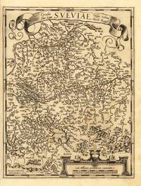
158737336Antwerp: Christopher Platin 1587. A very good example in excellent condition. 387 by 440mm 15 by 17 inches. Hand-Colored Original Copperplate Engraving by Abraham Ortelius depicting Wirtenberg Ducatus Accurata descriptio; tu qua omnia eius Opida Monasteria pagi nemora; fluminia et riuuli alicuius nominis diligentißimé exprimuntur. Auctore Georgio Gadnero. Published Antwerp Christopher Platin 1587. Sheet: 387 by 440mm 15 by 17 inches. A fine and original hand-colored example of Ortelius's celebrated cartographic work documenting this region of Germany with the precision and decorative artistry characteristic of the 15800s. Abraham Ortelius 1527-1598 was a Flemish cartographer and geographer from Antwerp widely regarded as the creator of the first modern atlas. His landmark publication Theatrum Orbis Terrarum 1570 set the standard for atlas-making for the next century presenting uniform copper-engraved maps with scholarly commentary. By Ortelius's death the Theatrum had appeared in 25 editions in seven languages. In 1575 King Philip II of Spain appointed him Royal Geographer. His maps engraved with extraordinary precision are among the most sought-after in antique cartography held in collections including the Plantin-Moretus Museum in Antwerp the Library of Congress and the British Library.This plate presents a original copperplate engraving with original hand coloring depicting the city of Wirtenberg Ducatus Accurata descriptio; tu qua omnia eius Opida Monasteria pagi nemora; fluminia et riuuli alicuius nominis diligentißimé exprimuntur. Auctore Georgio Gadnero. published in Antwerp Christopher Platin 1587. The view is framed with a decorative Baroque cartouche containing the title inscription. Such topographic views from Ortelius's workshop are primary historical documents of German urban history in the 1500s now prized equally by historians map collectors and interior decorators. Sheet measures 387 by 440mm 15 by 17 inches. In good condition overall with minor signs of age appropriate for a 16th-century engraving. Ready to frame. Broe. 113 Christopher Platin unknown
157928112Antwerpen: Platin 1579. Other. In excellent condition. 321 by 243mm 12 by 9 inches. Hand-Colored Original Copperplate Engraving by Abraham Ortelius depicting Württemberg Herzogtum. Published Antwerpen Platin 1579. Sheet: 321 by 243mm 12 by 9 inches. A fine and original hand-colored example of Ortelius's celebrated cartographic work documenting this region of Germany with the precision and decorative artistry characteristic of the 15700s. Abraham Ortelius 1527-1598 was a Flemish cartographer and geographer from Antwerp widely regarded as the creator of the first modern atlas. His landmark publication Theatrum Orbis Terrarum 1570 set the standard for atlas-making for the next century presenting uniform copper-engraved maps with scholarly commentary. By Ortelius's death the Theatrum had appeared in 25 editions in seven languages. In 1575 King Philip II of Spain appointed him Royal Geographer. His maps engraved with extraordinary precision are among the most sought-after in antique cartography held in collections including the Plantin-Moretus Museum in Antwerp the Library of Congress and the British Library.This original copperplate engraving with original hand coloring depicts the region of Württemberg Herzogtum published in Antwerpen Platin 1579. The map features a decorative Baroque cartouche containing the title inscription. The map records the political and geographic boundaries of the region as understood in 1579 offering a fascinating window into the history of German territorial organization. Sheet measures 321 by 243mm 12 by 9 inches. In good condition overall with minor signs of age appropriate for a 16th-century engraving. Ready to frame. Platin unknown
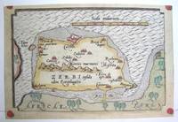
1590M3047Antwerp 1590. Excellent; narrow margins. Notes: This is the modern day island of Hawmat As Suq located about 300 kilometers southwest of Tunis on the South Western edge of the Gulf of Gabes. Size : 105x159 mm 4.125x6.25 Inches Coloring: Original Hand Coloring Category: Maps Africa North; Maps Mediterranean Sea unknown
1590910274CGAntwerpen:, Ortelius, nach 1590. Kupferstich 31 x 23,5 cm (hoch), Blattgröße 41,5 x 26,5 cm.
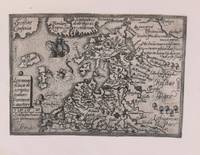
1579M8772Antwerp c. 1579. Margins are trimmed closely and laid on 19th century paper. Otherwise very good. . Notes: Map of Baltic region and Poland from the late 16th century with decorative border with sea monsters and tall ships. Size : 80x107 mm 3.15x4.21 Inches Coloring: Black & White Category: Maps Europe Estonia Latvia; Maps Europe Poland Lithuania; unknown
15842101091584. Auf Bütten mit Wasserzeichen "Zwei gekreuzte Pfeile". 35 x 19,7 cm (Plattengröße) 43,5 x 26 cm (Papier).
15842100981584. Auf Bütten mit Wasserzeichen "Wappen". 35 x 19,7 cm (Plattengröße) 43,5 x 26 cm (Papier).
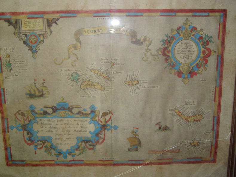
1584224251584 Orig. copper-engraving. Published by A. Ortelius after to L. Teixeira's map of the Açores. Dated 1584. Coloured. With title in decorative border, 3 ornamental cartouches, 2 ships, sea-monster and "Scala Leucarum". 32,5:46,5 cm (12 3/4 x 18 1/4 inch.) 2,5 x 46,5 cm Van der Krogt, Koeman's Atlantes Neerlandici, Vol. III B, 6350:31; Van den Broecke, Ortelius Atlas Maps, Nr. 24. - Stammt aus einer von fünf lateinischen Ausgaben, die in den Jahren 1595 - 1612 erschienen. Alle tragen das Datum 1584 in der großen Kartusche.A splendid sea chart of the Azores with three scrollwork cartouches; the ocean is decorated with sailing vessels. A fresh example of this scarce sea chart, based on Teixeira's single sheet map of Terceira from 1582, and a later manuscript atlas of the Azores islands. The Azores played a significant role in international sea trade as a victualling stop and shelter for ships sailing into the South Atlantic. In very good condition. The map was first issued in an edition of 100 examples in the Additamentum to the 1583 edition of Ortelius' Theatrum Orbis Terrarum, which is widely referred to as the first modern atlas and a landmark in the history of Western map making. Beginning in 1570, Abraham Ortelius and his successors published (and continuously added to) this monumental work for a period of over 40 years (not including the very rare edition of 1641), with text on the verso in Latin, Italian, German, Dutch, French, Spanish and English.References: Van Den Broecke 24. Meurs p 253-254.
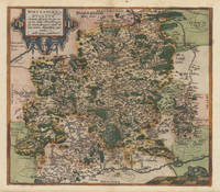
1574M6759Antwerp Belgium: Abraham Ortelius 1527-1598 1574. Very Good;. Notes: Latin text on verso. L58.<br><br>"Waclaw Grodecki his true name was Grodziecki which was latinized as Grodecius corrupt Godreccius was born about 1535. He was the son of a Silesian gentleman to whom belonged the village Grodziec in Cieszyn Silesia hence the family name. He entered Cracow University in 1550 and in 1555 was still there studying mathematics and philosophy. In 1556 he left for Leipzig as tutor to the son of a great noble and there too he entered the university. In 1557 he drew his well-known map of Poland. He travelled to Italy and after his return in 1561 took orders. In 1564 he received the degree of Master of Arts at the Cracow University. He later became canon of the chapter in Wroclaw this post having been ceded on his behalf by his elder brother Jan when he became bishop of Olomouc in 1572. Waclaw Grodecki followed his brother to Moravia in 1566 and settled for good in Brno where later he became dean of the collegiate chapter. Being to the end of his life a devoted Catholic and a protector of the Jesuits he was a major figure of the counter-reformation movement in Moravia. He was a man of humble character and good-natured. He died in Brno in 1591." Buczek<br> <br> Size : 373x498 mm 14.69x19.61 Inches Coloring: Original Hand Coloring Reference: Marcel P. R. van den Broecke #154. Category: Maps Europe Poland Lithuania; Abraham Ortelius (1527-1598) unknown
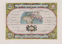
1590200018AG1590. Antwerp Ortelius 1590. Original hand-coloured engraving. Plate Size: 44 cm x 31 cm. Sheet Size: 53.7 cm x 38.5 cm. Original map. Very good actually stunning condition. Really clean and crisp. Generous margins. Reverse recto carries Latin text. Shirley 176; Broecke 186.1; Koeman III 0800H:31. Beautifully unusual and richly decorated map of the Ancient World based upon the work of Claudius Ptolemy from Ortelius' Parergon 'Supplement'. The depicted land masses of Europe Africa and western Asia are largely in their modern configurations although the place names on the map are based upon Ptolemy. The southern portion of Africa is missing and China is not included on the map. A small number of cities including Hispalis Seville Lutetia Paris Rome Byzantium Istanbul Hierusalem Jerusalem Alexandria and Memphis are identified. Relief shown pictorially. The mythical Luna Montes Mountains of the Moon - the fabled source of the Nile - can be seen in the southern half of Africa. Madagascar is also included. The climate zones are shown as 'Zona frigida et inhabitablis' 'Zona temperata et habitabilis' and 'Zona torrida et ob Solis nimium fervorem a veteribus inhabitabilis credita.' The tropics and Arctic and Antarctic circles are also shown. The 'Zona frigida' lying above the Arctic Circle and the region lying at the Equator are described as being inhospitable. The border of the globe carries longitudinal and latitudinal information. The outer areas of the map are decoratively patterned and there is one inset roundel map in each corner showing the different continents depicting in clockwise order Europe Asia Africa and the Americas. Ortelius' characteristic strapwork design ornaments the title cartouche above the globe as it does the cartouche seen beneath it. It bears the inscription: "En Spectator Pilae Totius Terrae Ichnographiam at Veteribus Usque ad Annum Salutis Nonagesimum Secundum Supra Milles Quadrigent. Cognitae Tantum Geographiam." Immediately underneath the illustrated landmass is a further cartouche similarly ornamented decorated with two lion heads and bearing an oval inset statement of responsibility in Latin script. The Parergon was conceived initially as a supplement to Ortelius' Theatrum Orbis Terrarum Theatre of the World. The work a vast and finely researched index of the Classical world was accompanied by a number of ancient world maps. Unlike the maps of the Theatrum the majority of which were reductions of earlier maps the maps of the Parergon were researched and drawn by Ortelius himself. The work was a great commercial success and the maps themselves set the standard for ancient world maps for the duration of the 17th Century. Abraham Ortelius was a Flemish cartographer and geographer conventionally recognized as the creator of the first modern atlas the Theatrum Orbis Terrarum Theatre of the World. He was one of the most notable figures of the Dutch school of cartography during its golden age approximately 1570s-1670s. unknown