399 résultats
17898547Jaeger, Johann Wilhelm Abraham 59,7 x 50 Francfort Sur Le Mein 1789 Carte topographique en noir de la fin du XVIIIe siècle, entoilée et dépliante, composée de 8 sections (14,5 x 25,5). Echelle de deux lieux d'Allemagne. Originaire de Bavière, Jaeger a été un des grands cartographes et marchands de carte allemands au XVIIIe siècle. On lui doit le Grand atlas d'Allemagne en LXXXI feuilles, dédié a sa majesté Joseph II, empereur des Romains. Exemplaire en très bon état. PHOTOS NUMERIQUES DISPONIBLES PAR EMAIL SUR SIMPLE DEMANDE-DIGITAL PHOTOGRAPS MAY BE AVAILABLE ON REQUEST
17898546& Jaeger, Johann Wilhelm Abraham 50 x 62,5 Francfort Sur Le Meyn 1789 Deux Cartes topographiques en noir de la fin du XVIIIe siècle [1789], entoilées et dépliantes, composées chacune de 8 sections (15,5 x 25). Les deux cartes se complètent. La première carte "contenante l'Archevêché Electorale de Tréves, une partie de l'Electorals Palatinat, les Comtés de Catzenelnbogen, de Sponheim, de Rheingraeffenstein, de Manderscheid Gerolstein, de Sayn, de Neuwith, de With Runckel, de Reifferscheidt, de Holtzapfel, le Rhingau, partie l'Archevêché Electorale de Mayence, et de divers païs partagés entre plusieurs Seigneurs, &c. La deuxième carte "contenante une partie de la Hesse et de Hesse Darmstadt : les principautés de Nassau, d'Hanau, une partie de l'archevêché electorale de Mayence et de l'abbaye de Fuld, les comtés et principautés de Solms, de Stollberg, d'Ysembourg, de Gærtz, de Runckel, et de plusieurs seigneuries et territoires de quelques villes de l'Empire &c". Gravée par Heinrich Hugo Coentgen. Représentation intéressante de la vallée de la Moselle sur la première carte. Echelle de deux lieux d'Allemagne. La Wettaravie (Wetterau) est le nom français pour désigner la région historique du Land actuel de Hesse. en Allemagne. Originaire de Bavière, Jaeger a été un des grands cartographes et marchands de carte allemands au XVIIIe siècle. On lui doit le Grand atlas d'Allemagne en LXXXI feuilles, dédié a sa majesté Joseph II, empereur des Romains. Exemplaire en bon état. PHOTOS NUMERIQUES DISPONIBLES PAR EMAIL SUR SIMPLE DEMANDE-DIGITAL PHOTOGRAPS MAY BE AVAILABLE ON REQUEST
17838545Jaeger, Johann Wilhelm Abraham 58 x 50 Francfort Sur Le Mein 1783 Quatre cartes topographiques en noir de la fin du XVIIIe siècle, 1783-1784, entoilées et dépliantes, composées chacune de 8 sections (14,5 x 25,5) La feuille II "contenant Une Partie De La Province De Groeningen"; la feuille III "contenant une partie du duché d'Oldenbourg et Delmenhorst de Friesland Orient et de la prov. de Grönningen; la feuille XI contenant une partie des Provinces Unies, savoir la province de Friesland occidentale, une partie d'Overyssel, de Gueldre, d'Hollande septentrionale, de differentes isles de la meer d'Allemagne, et du Zuider See; la feuille XII contenant une partie inferieure de l'évêché de Munster, une partie du duché d'Oldenbourg, de l'évêché d'Osnabruck, de Friesland orientale de Gröningen et d'Over Yssel, les comtés de Benthem de Lingen &&. Les quatre cartes se complètent et représentent au nord la continuité du littoral. Plusieurs bateaux et barques illustrent l'espace de la mer du nord.. Echelle de deux lieux d'Allemagne. Originaire de Bavière, Jaeger a été un des grands cartographes et marchands de carte allemands au XVIIIe siècle. On lui doit le Grand atlas d'Allemagne en LXXXI feuilles, dédié a sa majesté Joseph II, empereur des Romains. Le papier de la feuille II, dont la toile est auréolée, est un peu jauni. Ensemble en très bon état. PHOTOS NUMERIQUES DISPONIBLES PAR EMAIL SUR SIMPLE DEMANDE-DIGITAL PHOTOGRAPS MAY BE AVAILABLE ON REQUEST
1701046917Jena: Birchner 1701. Early Edition. Hardcover Vellum. Good Condition. Contemporary vellum soiled frontis and title page stained and detached with some chipping and old tape marks wear to first few pages a few old marks and notes but very good otherwise. Three works bound in one the first two by Hoping typically found together the last with added engraved title published in 1692 in Frankfurt Illustrated throughout endpapers with notes and a few hand sketches. The Ingeber work is a first edition. 155 7; 183 61; 180 4pp<br/><br/>Three early chiromancy volumes bound up together Size: Octavo 8vo. Quantity Available: 1. Shipped Weight: Under 1 kilo. Category: Science & Technology; Magic Paranormal & Occult. Inventory No: 046917. Birchner hardcover
1701046917Jena: Birchner 1701. Early Edition. Hardcover Vellum. Good Condition. Contemporary vellum soiled frontis and title page stained and detached with some chipping and old tape marks wear to first few pages a few old marks and notes but very good otherwise. Three works bound in one the first two by Hoping typically found together the last with added engraved title published in 1692 in Frankfurt Illustrated throughout endpapers with notes and a few hand sketches. The Ingeber work is a first edition. 155 7; 183 61; 180 4pp<br/><br/>Three early chiromancy volumes bound up together Size: Octavo 8vo. Quantity Available: 1. Shipped Weight: Under 1 kilo. Category: Science & Technology; Magic Paranormal & Occult. Inventory No: 046917. Birchner hardcover books
1743BS45SLIM14London: J. Nourse 1743. Pamphlet disbound. viii 155pp. Last 3 leaves slightly crumpled to top edge. Private ownership. bs45. Soft Cover. Good. J. Nourse Paperback
1743AQ15123London: Printed for J. Nourse 1743. viii 155pp 1. Recent navy half-morocco blue cloth boards lettered in gilt T.E.G. Very minor wear to extremities. Recent marbled endpapers marginal repair to penultimate leaf else internally clean and crisp. The first English translation of the correspondence of Dutch ambassador to the court of France Abraham van Hoey 1684-1766 a position he held for 20 years prior to being relieved of his duties in 1747 evidently having dissatisfied members of his nation's government for too often aligning with Louis XV. ESTC T84028. First English edition. 8vo. Printed for J. Nourse hardcover
1783SET21-A-1London: Not Stated 1783; 1811-1816. Leather. Good Only. 18" by 11". None. The 1783 Domesday Book with 1816 Additional Volumes. The text of this work is in Latin with 'Introductions' in English. Whilst title pages for Volumes I and II were issued in 1816 these volumes are bound without as usual. Publication Information for Volumes I and II from the ESTC. Citation number: T97297. System Number: 006367139 Volume III includes the informative 1816 'Introduction' by Henry Ellis an English librarian. He was educated at the Mercers' School and St John's College Oxford where he acted as an assistant at the Bodleian Library. He was first appointed to a position at the British Museum in 1800 and was chief librarian from 1827 to 1856. Ellis was knighted in 1833. An important work normally commanding £3000- £4000. We have discounted these to allow for the rebinding they deserve. With two interesting ink inscriptions concerning the text including one from 'the eminent antiquarian' David Turner in Volume III. The Domesday Book is the record of the great survey of England completed in 1086 executed for William I of England otherwise known as 'William the Conqueror'. It was written in Latin although there were some vernacular words inserted for native terms with no previous Latin equivalent and the text was highly abbreviated. Abraham Farley d.1791 was a lifelong civil servant who was appointed deputy chamberlain of the Exchequer in 1736 and soon became involved with the public records at the Chapter House of Westminster Abbey. First amongst these was the Domesday Book of which Farley became custodian granting visiting antiquaries access to the Book and making transcripts for a fee. In later life Farley was to produce the first printed edition of Domesday Book. Following a Parliamentary order in 1767 Farley was appointed co-editor of the Domesday printing project in 1770 alongside Charles Morton of the British Museum. Sir Henry Ellis 1777 1869 was an English librarian. He was educated at the Mercers' School and St John's College Oxford where he acted as an assistant at the Bodleian Library. He was first appointed to a position at the British Museum in 1800 and was chief librarian from 1827 to 1856. Ellis was knighted in 1833. He edited various works on antiques and wrote an Introduction to Domesday Book. In a half calf binding with marbled paper-covered boards. Externally a trifle rubbed resulting in small loss to leather on spine volumes I and IV. Backstrip partially detached to volume II missing to volume III. Boards detached. Internally generally firmly bound. Pages bright and clean with scattered spotting. Pages occasionally age toned to edges. Nameplates and institutional labels to front pastedowns. Good Only Not Stated hardcover
17182585<p>Very Good. 1718. First Edition. Pr. Large engraving featuring royal lineage of Scandinavia as well as two finely illustrated maps: "Nouvelle Carte du Royaume de Suede" & "Carte du Royaume de Gothie". Period hand-coloring. 17 in x 40.5 in. ; 17''x 40.5''; All shipments through USPS insured Priority Mail. .</p>
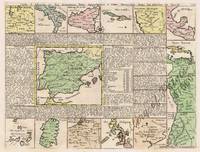
171357660hand-coloured copper engraving. Fascinating map from the 'Atlas historique….' Second State plate no. 34; originally one then extended to 7 volumes over the span of several years - The colonial power SPAIN is shown in the centre surrounded by small depictions of all its territorial possessions throughout the world including the Philippines supported by a geographical and historical text for each map. Philipines is mis-spelled with one 'p'. Reference: UNRECORDED - not in Quirino; Koeman Cha1 published in Amsterdam.
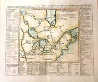
1719M1126Paris c.1719. Very Good;. Notes: From Chatelain's Atlas Historique.<br>This map is based on the 1703 map by Lahontan. The map covers the area of South Hudson Bay and concentrates on the Great Lakes. The St. Laurent is shown running into the Great Lakes from present day Lake Winnipeg. Georgian Bay is named "Baye de Toronto". English French Iroquois treaty is shown and many early settlements forts trading posts missions friendly and hostile Indian Villages are clearly marked. This is a highly significant and informative fur trade map. Surrounding the map are a number of descriptive panels contained lists of the birds fish plants and insects of Canada. Also the Indian tribes of the different regions together with a list of various trade goods including whiskey which were popular among the Indians. Size : 368x458 mm 14.49x18.03 Inches Coloring: Hand Colored Reference: Koeman II: Cha 7; Sellers and Van Ee 2; Kershaw II: 307. Category: Maps Canada; Maps North America Great Lakes; unknown
171962639/62640<p>original outline-colour copper engravings enhanced hand-colour. EXTREMELY RARE stunning World map in 2 sheets from the extensive multi-volume 'Atlas Historique' vol. 6 no. 30 p. 117; published by Chatelain Amsterdam. One of the most informative decorative and impressive maps centered on the Pacific available. Printed on four large sheets the overall map is of wall-chart proportions and a veritable pictorial encyclopaedia of the World including the Philippines; many famous voyagers' tracks/routes are indicated. A great example of early 18th Century craftsmanship! Condition: 1st sheet - folds as issued small tear on lower centrefold; 2nd sheet - folds as issued; due to imperfect printing the neatlines are not perfectly parallel neither horizontally nor vertically. Otherwise Excellent condition. References: Not in Quirino; Phillips 579; Goss Kartenkunst Taf. 7.5; Ders. North America map 52; Portinaro/Knirsch p. 216/7 all 3 with crude but col. image.; Tooley California No. 80; Tooley Early Maps of Australia No. 66; Wagner NW Coast America Nr. 511; Lowery No. 291 only Northern part; Lietz Insulae India Orientalis p. 132<br /><br /><br /><br /></p> Chatelain, Amsterdam.
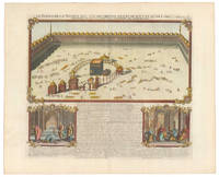
1719NL-02162<p>This is Henri Chatelain's dramatic and detailed capture of the <em>Haram</em> or Sacred Precinct in Mecca—the holiest site in Islam. It provides a detailed view of the historic complex which draws millions of pilgrims annually. In the center of the view the quadratic black Kaaba dominates. According to Islamic tradition this complex stands on the remains of the first temple that Abraham and his son Ishmael built for God.</p><p>In addition to the Kaaba several shrines and other buildings have been drawn in their relative positions and domed porticoes frame the enormous courtyard holding it all. In this manner the view almost takes on the character of a plan. Chatelain brings his view to life by including many worshippers within the complex.</p><p>While the view of the Holy Precinct occupies the upper register of the print in the lower register we find two smaller vignettes depicting the various positions that Muslims assume during prayer. Between the vignettes is a text that includes a legend and key related to the larger view as well as an introduction to the Islamic faith and tradition.</p><p><strong>Census</strong></p><p>The copper-engraved view comes from Chatelain's seminal seven-volume <em>Atlas Historique</em> published in Amsterdam between 1705 and 1720. The atlas combines the finest engraving and cartographic craftsmanship with academic studies of geography history ethnology heraldry and cosmography and it was one of the most widely distributed atlases in the 18th century.</p><p><strong>Context is Everything</strong></p><p>When Chatelain's detailed plan of Mecca was first published it was a true rarity. Few European travelers had ventured so profoundly into Arabia and the accounts of Muslims did not resonate broadly among the European intelligentsia at the time. Western Arabia particularly Mecca had been subjugated by the Ottoman Empire when Selim I defeated and dissolved the Mamluk Sultanate in Egypt. For centuries the Mamluks had controlled access to the sacred cities but now Barakat bin Muhammed the Sharif of Mecca was forced to acknowledge Ottoman supremacy. The only European to ever truly penetrate Mamluk Arabia was the Italian traveler Ludovico di Varthema who in 1502-03 visited Mecca with a Hajj caravan on his journey to India.</p><p>But a French traveler truly opened Western Arabia to the world. The Parisian Jean Chardin 1643-1712 was a distinguished French traveler merchant and polyglot whose extensive travels in the Middle East and beyond significantly impacted the European understanding of Islam and its holy sites in the 18th century. Chardin spent eleven years exploring the Middle East where he gained access to the Persian court being appointed a royal merchant by Shah 'Abbas II. His journeys took him through Persia Turkey India and Georgia before he eventually settled in England. Among the most notable aspects of Chardin's voyages was his attempt to depict Islam's holy places particularly Mecca and Medina. His depictions were mainly based on information he acquired from Muslims who had performed the Hajj.</p><p>Depictions of Islam's holiest sites were virtually non-existent in Europe at his time and Chardin's drawings constitute some of the earliest and best sources available. There is an unfinished manuscript plan of the Prophet's Tomb in Medina at the Royal Society in London. Still the more impactful image was Chardin's completed plan of the Kaaba precinct in Mecca. While this pioneering plan accurately captures the individual buildings and minarets including the colonnaded porticoes surrounding the central courtyard it also conflated elements from Medina and Mecca the circular colonnade around the Kaaba.</p><p>Despite traveling with two professional artists including Grélot the drawings attributed to Chardin were most likely his work demonstrating his engagement with documenting his experiences. His detailed accounts and illustrations were later included in his publication <em>Voyages en Perse et Autres Lieux de l'Orient</em> the first volume published in 1686. Further volumes followed in 1711. These works were praised for their detailed observations and accuracy providing a valuable non-Persian perspective on the Safavid and Ottoman empires and it is clear that they were the source for Chatelain's view.</p><p>Chardin's extensive travels and keen observations earned him a knighthood from Charles II of England for his services to the East India Company. His pioneering contributions remain crucial sources on Persia and Arabia's political history and cultural landscapes.</p><p>Cartographer:</p><p><strong>Henri Abraham Chatelain 1684 – 1743</strong> was a Protestant pastor Huguenot from Paris who due to his faith was forced to flee his native France. He settled first in London and later in Holland where he worked from both The Hague and Amsterdam during the early 18th century. While his primary calling was as a preacher his <em>Atlas Historique</em>became a huge success partly due to the vivacious decoration and abundance of information on his charts.</p>
176680021Oosterbeek:: J van Hooimaand 1766. original gilt-embossed decorative wrappers. . A fine copy. 8vo. J van Hooimaand, unknown
179129150New York: Printed by W. Durell 1791. viii 9-95 1 blank pp. Stitched and disbound. Lightly foxed and worn. Good.<br/><br/> The first American printing issued from New York in 1765. Hellenbroek was a Dutch Reformed Minister who died in 1731. <br/>Evans 23438. NAIP w036492 5. Printed by W. Durell unknown books
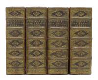
172712222Amsterdam Hendrik Burgers Gerrit Bouman Isaak vander Putte Cornelis Oterlyk en Pieter Verschueren/Dl.2: Rotterdam Adriaan van Dijk 1727/1729/1728/1728. 4 delen titelprent 6 4 888 18 6 1018 26 4 1022 21 8 1062 71 p. Origineel Leer met ribben 4°. Fraaie set met in de delen een ex-libris stempel van K. CH. Ederveen Muntkade 5 Utrecht en een andere naam in oud handschrift: T of J Diermanse de laatste is er in het vierde deel op het schutblad uitgesneden. Amsterdam, Hendrik Burgers, Gerrit Bouman, Isaak vander Putte, Cornelis Oterlyk, en Pieter Verschueren/Dl.2: Rotterdam, Adriaan unknown
170251705100066Adriaan Van Dijk 1702. Hardcover. Acceptable. Fair 3 BOOK SET of hardcovers. ORIGINAL 1702 1703 AND 1718 PRINTINGS. PARTS 12 AND 4 MISSING PART 3. Text unmarked. Pages and text still quite nice and clean. Covers show heavy edge wear with heavy rubbing/scuffing and bumped corners. Spines scuffed and rubbing. Hinges cracked and loose. Fair 3 BOEKEN SET hardcovers. ORIGINELE 1702 1703 EN 1718 AFDRUKKEN. PARTS 12 EN 4 MISSING DEEL 3. Tekst ongemarkeerd. Pagina's en tekst nog steeds heel mooi en schoon. Omslagen tonen zware randverschijning met zware wrijven / scuffing en gestampte hoeken. Spines scuffed en wrijven. Scharnieren gebarsten en los; 100% Satisfaction Guaranteed! Ships same or next business day! Adriaan Van Dijk hardcover
171811360Rotterdam Reinier van Doesburg 1718/1720. 2 delen titelprent met verklaring 26 1018 2 1119-2258 51 p. Origineel Perkament 4° Enkele naamsvermeldingen op het eerste vrije schutblad titelpagina tweede deel verstevigd aan de randen mist het portret. Rotterdam, Reinier van Doesburg unknown
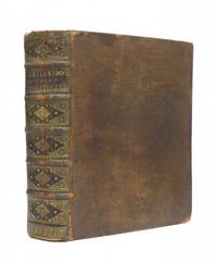
174212001Amsterdam Adrianus Douci 1742. 46 676 22 p. Origineel Leer met ribben goudbestempeld 4° Amsterdam, Adrianus Douci unknown
175214421Amsterdam c1752. 565 by 935mm. 21.5 by 36.75 inches. Engraving with etching on two sheets joined. View of the Plantage Muidergracht and the Jonas Daniël Meijerplein. The view shown from the present day Mr. Visserplien the busy intersecti.on in central Amsterdam depicts the Portuguese Synagogue on the left and the High German or Great Synagogue. These momumental buildings now house the Jewish Historical Museum. The first Jews to settle in Amsterdam were the Sephardim who had been expelled from Portugal and Spain in 1493. They were joined in the following decades by the Ashkenazi from Central and Eastern Europe the first of whom had come from Germany in 1600. In those years the only available land for them was at the outskirts of the eastern side of the Centrum the island of Vlooienburg surrounded by the Amstel River and the canals so they settled along the island's main street Breestraat which quickly became known as Jodenbreestraat. The Great Synagogue now the Jewish Historical Museum and the Portuguese-Israelite Synagogue were opened in 1671 and 1675 respectively. The Portuguese Synagogue was the place where Spinoza was placed under the ban by the Sephardic Jewish community in 1656. Pieter Stevensz. van Gunst 1659-1732 also known as Pieter Stevens van Gunst or Petrus Stephani was a Dutch draughtsman copperplate engraver and printmaker active in Amsterdam London 1704 and the Dutch town of Nederhorst 1730-1731. Abraham Rademaker 1677 21 January 1735 was an 18th-century painter and printmaker from the Northern Netherlands. Rademaker was born in Lisse. According to the RKD he was a versatile artist who painted Italianate landscapes but is known mostly for his many cityscapes and drawings of buildings that were made into print. R.W.P. de Vries auction 1925: 295. unknown
174523029Lutetiae Parisiorum M. S. David 1745 -in-12 plein vélin janséniste un volume, reliure janséniste d'époque en plein vélin ivoire in-dix-huit (jansenist's binding full vellum duodecimo in-18) (12,5 x 7,6 cm), dos long (spine without raised band), titre manuscrit à l'encre brune en haut du dos (handwritten title on the spine), plats muets (cover without text) à rabat, toutes tranches lisses (smooth edges) bleues, texte en italien, orné d'un Frontispice gravé (noté : Il pastor fido) d'après Zacharias WEBBER, gravé sur bois en noir par Abraham DE BLOOTELING et 5 planches de ce dernier, incluses dans la pagination, 260 pages, 1677 In Colonia [sans nom d'Editeur mais c'est : Elsevier, imprimé par Hackius à Leiden],
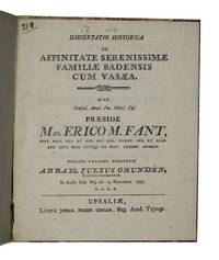
1797AQ32362Upsaliae i.e. Uppsala: Litteris Johan. Fredr. Edman 1797. 4 8pp. With two folding genealogical tables. Handsomely bound in later vellum-backed 'Dutch' floral paper boards. Lightly rubbed and marked. Paper label to upper board with title in manuscript and letterpress monogram of Swedish Count Gustaf Trolle Bonde 1773-1855. The sole edition of an academic thesis on the genealogy of the Swabian Zahringen dynasty rulers of Baden submitted by Abraham Julius Grundén 1779-1834 to professor of history at Uppsala University Eric Michael Fant 1754-1817. Grundén went on to serve as an advisor at the Swedish Administrative Court of Appeals and forge a career as a composer writing music primarily for the Aurora Order at Stockholm of which he was music director and later Grand Master. . First edition. Quarto. Litteris Johan. Fredr. Edman hardcover
177819980Paris: P-M. Lamy 1778. First edition. leather_bound. Contemporary mottled calf covers rehinged. Two Vols. in one. Very good. 8 & 10 pages in text. 22 x 17 cm. Engraved frontispieces 283 plates. An antiquary of Flemish descent his early interest in gem collecting as part of his cabinet of curiosities eventually spawned interest in Greco-Roman intaglio gems; his collection purchased in 1609 on behalf of Henry Prince of Wales -- with more than a representative sampling of specimens here. His first work "Dactiliotheca" published 1609. BRUNET Vol. II p.1671. Index of plates in each volume generally clean wide margined plate pages book label and small ownership inscription dated 1857 of same individual corner wear raised bands leather spine label spine compartments decorated in blind. P-M. Lamy unknown