285 résultats
1658B6453Frankfurt a. M: J. Bayern J. W. W. Serlin 1658. Covers and spine worn and reinforced; otherwise generally very good. . Binding: Contemporary blind full calf; spine with four 4 bands and embossed title on two. Notes: Text in German. Gothic Script; with Latin inserts in Roman script.<br>Final and most extended edition with 67 plans. <br>This is the most expanded edition and therefore most desirable edition of this work by Saur; the first was published in 1581 the ones that followed under varying titles and the present revised work in 1658. Size: small quarto 201x115mm. Illustration: Illustrated title copper printed title with printer's device rubricated initials at openings; head and tailpieces; sixty-seven 67 city plans at 2 54 88 109 166 173 188 201 207 241 265 291 309 400 463 494 500 523 538 545 557 583 587 597 703 762 779 837 880 885 935. 4 23 37 69 76 84 93 113 117. 2 25 46 102 107. 60. 29. 10 17 74. 15 28 50 56 73. 51 84 119. 36 47 64 89 148 173 188 195. 16. Two of the plans are full-page Jerusalem/Hierosolyma and Rom/Roma; all remaining are half-page in size and comprise Aach/Aquisgranum Aix La Chapelle. Antorff/Antwerpen Augusta/Augspurg Basel Braunschweig/ Brunopolis Breszlau Bruessel Burgos Bremen Calaris Cassel Coelln/Colonia Constantinopel Dreszden Erdfurt/Erffurt Franckenberg Franckfurt am Mayn Franckfurt an der Oder Freyburg in Briszgaw Friedberg in der Wetterau Fulda Geneva/Genff Gandavum/Gent Genua Groeningen Hamburg Hanaw Heydelberg/Budoris Jena Koenigsperg Landeshut in Baeyern Leipzig Leon/Lugdun/Lion Lisabona/Ulixibona Londen/London Loeven/Lovanium Luebeck Lueneburg Luettich/Leodium/Liege Magdeburg/Meydenburg Marpurg/ Martisburgum Meintz/ Moguntiae Muenchen/Abadiaum Muenster/Monasterium Nuernberg/Norinberga Osnabruck Palma Parisz/Lutetia Parisiorum Prag/Praga Regenspurg/Ratisbona Riga Roan/Rouen/Rohmagus Rostock/Rhodopolis/ Laciburgum Schweinfurt Speyer/Nemetum Straszburg/ Argentoratum Trier/Treveris Tuebingen Venedig/Venetia Ulm/Rhetia Wien/Fabiana/Fabana/Faviana Wittenburg/Wittenberg Wormbs/ Wormatia Wuertzburg/Erebipolis/Herbipolis Zuerch/ Tigurum/Turegum. References: Graesse VI 276; Bachmann Pages: Ll: bl. 2 939 bl.; collated as: Bl.2; i-iv with illustrated title printed title dedication and to the reader; A1 -Zzzzz4 Aaaaaa1 - Eeeeee4 Ffffff1-2 A1-R4 S; A1-O4 At1-It4; Aï“1- Dï“4 Eï“1-3; aA1- mM4 nN1-2; Aa1-Ll4; An1-Rn4; ∞a1-∞z4 ∞aa1-4 bb1-3; A1-C4 bl. Category: Book Atlas & Cartography; Book Europe Germany; J. Bayern, J. W., W. Serlin unknown
169127448<p><strong>1691 German Monsters Satanic Rituals Judas DEMONS Dragons Abraham Sancta Clara</strong></p><p>Abraham a Sancta Clara was a 17th-century German clergyman known for his eccentric Augustinian views. His sermons were popular not only because of content but because he was known to be entertaining and satirical in his delivery. His main book "<em>Judas Der Ertz-Schelm</em>" is a German personal devotional which discusses moral doctrines as well as Bible history and ecclesiastical poetry focusing on Judas Iscariot and his betrayal of Jesus Christ.</p><p>This title was extensively used by Adolf Hitler and the Nazi regime as a supplement to their foundational philosophies.</p><p>Item number: #27448</p><p>Price: $750</p><p>SANCTA CLARA Abraham a</p><p><strong><em>
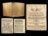
Judas Der Ertz-Schelm/ Für ehrliche Leuth/ Oder: Eigentlicher Entwurff/ und Lebens-Beschreibung deß Iscariotischen Bößwicht : Worinnen underschiedliche Discurs sittliche Lehrs-Puncten/ Gedicht/ und Geschicht/ auch sehr reicher Vorrath Biblischer Concepten.
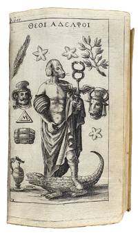
 </em></strong></p><p>Salzburg: Melchior Haan 1691.</p><p><u>Details</u>:</p><p><!-- if !supportLists-->· <!--endif-->Collation: Complete with all pages;</p><p><!-- if !supportLists-->o <!--endif-->28 457 11</p><p><!-- if !supportLists-->o <!--endif-->Allegorical illustration of Judas hanging himself</p><p><!-- if !supportLists-->· <!--endif-->Provenance: Handwritten – <em>Antonius Hacke</em></p><p><!-- if !supportLists-->· <!--endif-->Language: German</p><p><!-- if !supportLists-->· <!--endif-->Binding: Vellum; tight and secure</p><p><!-- if !supportLists-->o <!--endif-->One functional clasp</p><p><!-- if !supportLists-->· <!--endif-->Size: ~8in X 6.25in 20cm x 16cm</p><p>Our Guarantee:</p><p>Very Fast. Very Safe. Free Shipping Worldwide.</p><p>Customer satisfaction is our priority! Notify us with 7 days of receiving and we will offer a full refund without reservation!</p><p><u>Photos available upon request. </u></p> Melchior Haan, hardcover
166341874Nuremburg: Heirs of J. & W. Endter 1663. 8vo. 6 3/16 x 3 3/4 inches. xiv 998 xl pp. Title in red and black engraved frontispiece and 42 plates 7 folding. Early ownership signature on front pastedown. Early 18th-century lengthy manuscript commentary referencing passages on Brahmins from a work by Johann Albrecht von Mandelslo 1616-1644. Contemporary vellum<br/> <br/> First German Edition of one of the earliest European accounts of Hinduism in Southern India by a missionary who worked in Palicatta Coromandel for ten years from 1630 enlarged by supplementary accounts of Asian African and American religions not included in the Dutch and French editions.<br/> <br/> Abraham Roger was a Dutch missionary and linguist who spent a significant portion of his career working in India under the Dutch East India Company VOC. He was stationed in Pulicat a trading hub on the Coromandel Coast of South India where he worked among the Tamil speaking population. His experiences as a missionary coupled with his interest in local culture prompted him to document Hindu religious practices and beliefs culminating in this notable work. First published in Dutch in 1651 and translated into German in 1663 it is one of the earliest and most significant works by a European exploring Hinduism in South India. Roger's approach was distinct in its attempt to understand and accurately portray Hinduism a religion he sought to comprehend despite his missionary objectives. His work stands out for its translations of Hindu hymns and descriptions of temple rituals and he drew much of his knowledge from his close collaboration with local Brahmins reflecting a relatively objective tone compared to other European writings of the period. Despite his Eurocentric and missionary perspective Roger was unique in that he did not entirely dismiss Hinduism but rather engaged with it to create one of the earliest detailed European accounts of the religion.<br/> <br/> Sabin 72603; JCB III p. 92; Ackermann V 1273; Landwehr VOC 65. Heirs of J. & W. Endter unknown
167014709Schipper Amsterdam 1670 1 vol. In-4 de 7 ff.n.ch. 371 pp. 2 ff.n.ch. (table); basane brune de l'époque, dos à nerfs orné, pièce de titre, tranches rouges (coiffes usées, deux mors fendus, coins émoussés).
1663I1TG729PBDLDAntwerp: Marcelis Parijs 1663. Later boards covered with decorated paper. 8vo. Third edition of a handbook on the plague by Eduardus Putman enlarged and improved by Abraham Lenertsz Vrolingh. The first edition was published in 1603 in Amsterdam a second in 1646 in Zaandam. The present edition was most likely designed so that it could also be bound with Der matroosen ghesontheyd an account of scurvy by Vrolingh. In the preface Vrolingh states that by joining the two works both sailor and soldier would benefit from the knowledge.Putmans manuael seeks the cause of the plague in astrology holding Mercury responsible for the illness in the whole body and other planets for specific regions of the body such as behind the ears Saturn and the moon in the armpits Mars and the sun and in the groins Venus and Jupiter. It also discusses the influence of the four elements: water fire earth and air. Other subjects covered are the plague in pregnant women and a description of various symptoms such as headache heart palpitations thirst fever and diarrhoea followed by suggested treatments selected from experience. Most of the medicines pills and powders are made from plants and herbs such as nettle rhubarb rosemary and camomile. With the bookplate of Van der Hoeven. Owner's manuscript note on flyleaf.l BMN I p. 209; Dijstelberge "Plague and print" 1663/8; STCN 3 copies; STCV 1 copy; cf. Krivatsky 9325 1603 Amsterdam & 1646 Zaandam eds. Marcelis Parijs, hardcover
166964891669 Amstelodami, sumptibus Andreae Frisii, [Amsterdam, Andrea Frisi], 1669. 3 parties en 1 vol. in-4: 18.5 x 24.5 cm [5] ff., [4] pl. grav. dép, 96 pp., [6] ff. d'index, [4] ff., 96 pp. Troisième et meilleure édition de ce curieux ouvrage, d'après Brunet, avec les gravures de la Table Isiaque d'après Enea Vico, absentes de précédentes éditions. Notre exemplaire comporte 43 gravures en taille-douce. Un frontispice gravés par Blooteling, 8 planches à pleine page, 26 figures dans le texte et 8 des 11 sections de la Table Isiaque réalisées par Giacomo Franco d'après les gravures de Vico parues en 1559, ces 8 sections sont regroupées en 4 grandes pl. dép. Il manque les 3 sections de la bande centrale de la table. Reliure de l'époque en parchemin. Dos lisse avec titre manuscrit à l'encre noir. Bel exemplaire
1646910379CGParis:, Mariette, 1646. Grenzkolorierter Kupferstich 40,5 x 54 cm, Blattgröße 43,5 x 59 cm.
1669D6035Paris: Frederic Leonard 1669. First Edition. Hardcover. Very Good. 4to 242 x 185 mm. 120pp. Printers woodcut device on title depicting the winged lion of Evangelist Mark and motto Virtute invidiam vince Virtue overcometh envy and the legend Pax tibi marce Evangelista meus. 5 engraved folding plates 4 by Sebastien Le Clerc and one by Abraham Bosse depicting a chameleon on a branch and a plate with chameleons skeleton and organs in the upper part on a trompe-loeil sheet; and the same anatomical analysis for the beaver the camel the bear and the gazelle decorative woodcut head- and tail-pieces. Contemporary mottled calf spine gilt in compartments plates with some tears along folds repaired on verso some light darkening minor marginal worming at end; light edgewear. From the collection of Charles Philippe Robin 1821-1885 French doctor anatomist and politician bibliographical note at foot of title. Other early inscriptions to title referring to the engraver M. LeClerc and on rear pastedown to the state of the engravings. <br/><br/>First Edition and second publication dealing with the comparative anatomy of the animals the chameleon the beaver the camel the bear and the gazelle. Perrault scientist and naturalist was the leader of a team of comparative anatomists called the Parisians that included Guichard-Joseph Duverney Jean Pecquet Moyse Charas and Philippe de la Hire. Their investigations began in June 1667 with a thresher shark and lion from the royal academy and went on to encompass forty-nine vertebrate species. The detailed reports and exact descriptions on these dissections were the first of a long series of anatomical descriptions which ultimately included those of twenty-five species of mammals seventeen birds five reptiles one amphibian and one fish. Perrault and the team of Parisians prided themselves on several discoveries and in the process debunked many popular myths attached to certain species such as the legend that salamanders live in fire or that chameleons subsist on air. The scientists also recorded how they obtained their results providing a glimpse of how such anatomical research was conducted in the seventeenth century. The work is illustrated beautifully with five large folding plates by the expert painter engraver and writer Sebastian Leclerc 1637-1714 four of which were engraved by Leclerc and one by the watercolor painter writer and printmaker Abraham Bosse c. 1604-1676. Very fine work; the large folding plates remain fresh and intact. No such detailed and exact descriptions and illustrations had been published before. It is hard to measure another such important addition to the anatomical study of animals. Frederic Leonard hardcover books
1659ABC_47611Amsterdam: J. Rieuwertz 1659. Contemporary overlapping vellum. Small 8vo. With a woodcut title-vignette showing a witch on a broomstick leaving a house through the chimney 4.3 x 5.2 cm 13 etched full-page illustrations on 8 plates by Salomon Savry. An exceptionally rare first edition of a book focusing on the subjects of witchcraft sorcery demonology and black magic. The author passionately expresses his dissatisfaction with the brutalities inflicted upon individuals accused of being witches using vivid and disturbing illustrations as evidence. Notably the book features a captivating woodcut title vignette depicting a witch's daring escape through a chimney. In the image her legs hang from the opening inside the house while she simultaneously rises on her broom outside the chimney creating a striking visual effect. Abraham Palingh is a somewhat elusive figure in Early Modern Dutch literature and his book provides a fascinating insight into the attitudes of an educated man toward witchcraft. He claims that his 't Afgerukt Mom-aansight Der Tooverye is based on firsthand accounts. Information regarding the occurrence of harmful sorcery and attitudes towards sorcery in Amsterdam and Haarlem has been documented from the initial witchcraft trials to the point where such crimes were no longer a concern for the judiciary. Between 1542 and 1566 trials for harmful sorcery took place in Amsterdam while Haarlem witnessed similar trials in 1549. Historical accounts of both cities as well as Jacobus Scheltema's History of Witch Trials published in Haarlem in 1828 make mention of sorcery trials in Amsterdam. However these references often provide only superficial details despite the potential for valuable insights found in the actual procedural documents. Conversely little information about witchcraft in Haarlem can be gleaned from existing literature. Abraham Palingh author of 't Afrukt Mom-aansight der Tooverye published in Haarlem in 1659 briefly mentions a few cases of sorcery accusations that he claims to have personally known yet his accounts remain vague.The fine and copperplate illustrations were made by Salomon Savry 1594-1683. He was a recognised engraver of his time highly involved with the Amsterdam book industry of the seventeenth century. Some wear to binding. Ex libris from the library of Leontine Buijnsters-Smets. Light browning and foxing. Otherwise in very good condition.l Bibl. Med. Neerl. I p.150; Muller 539 1725 edition; Scheepers I 552; STCN 841091951 12 copies; Waller 1315 1725 edition; WorldCat 56854247 3 copies. J. Rieuwertz, hardcover
1602902209AGAntwerpen, [1602]. Kupferstich 36,5 x 49,5 cm, Blattgröße 40 x 54,5 cm.
160312725Antwerp Jan Baptist Vrients / Robert Brunaeu 1603. Theatrum orbis terrarium followed by Parergon sive veteris Geograpiae aliquot tabulae followed by Nomenclator Ptolemaicus. Complete copy bound in a contemporary vellum binding stamped with multiple friezes on the covers and 5 raised bands on the spine 358 f. Folio. Illustrated edition with an engraved allegorical frontispiece the arms of the Kingdom of Spain on the verso an engraved portrait of Ortelius an architectural frontispiece Parergon and 156 engravings. including 151 engraved maps 33 of which are in the Parergon as well as 3 plates of views and 2 plates of costumes. Some pages of the text are foxed and the stamp has been scratched off on the title page. Restoration work at the bottom of the two costume plates. Reinforcement in the margin of the inner hinges of 7 maps. H. 46 x W. 32 x D. 10 cm. / H. 18.11 x W. 12.6 x D. 3.94 inch. The finest edition of this iconic atlas considered to be the first true atlas the first true atlas Van der Broecke. ""The unique place occupied by Ortelius' Theatrum in the history of cartography is mainly due to its status as the world's first regularly produced atlas . Its form and content set the standards for subsequent atlases"" Koeman 1969 III 29. Ortelius' atlas was revolutionary because it was the first attempt to present the geography of the world in a uniformly produced collection of maps of all known parts of the world. Ortelius designed the maps himself basing his designs on the cartographic sources that he had at hand and equally revolutionary also mentioning his sources on the maps and once finished had them engraved by Frans Hogenberg and Ambrosius and Ferdinand Aertsen. Finally Gielis Coppens van Diest printed the maps after which they could be coloured also in a uniform style and bound in a logical order in one volume. These atlases were a new phenomenon and proved to be very popular in Europe. Soon editions were published in various languages of Europe in print runs of a few hundred copies each. A perfectly complete copy of the Theatrum Orbis Terrarum the Parergon and the Nomenclator Ptolemaicus in its original colours. Literature: Van de Krogt/ Koeman IIIA 31:053; Adams O-335; Phillips 382; Shirley 122 Antwerp, Jan Baptist Vrients / Robert Brunaeu hardcover
1603328971Antwerp: Ortelius Abraham 1603. unbound. Map. Engraving with hand coloring. 17 3/8 x 21 1/2" Framed in Eli Wilner carved frame.<br/> <br/> Beautiful map of the Holy Land bordered by 22 medallions depicting Abraham's wanderings. An inset map shows the path Abraham took. Ortelius used both Ptolemy and the Bible as sources for the map and based the medallion scenes on drawings by Maarten de Vos also of Antwerp. Latin text on verso. Expert repair to lower margin minor scattered stains in margins. Abraham Ortelius 1527 - 1598 a Flemish cartographer and geographer is widely regarded as one of the important and influential cartographers in history. He is known for his "Theatrum Orbis Terrarum" which was the first modern atlas. Van den Broecke 183.2 1603Lv; Laor 547C. Antwerp 1603<br/> <br/> Ortelius, Abraham unknown
161230715Antwerp: Balthasar Moretus 1612. Other. A very strong impression. In excellent condition. 353 by 457mm 14 by 18 inches. Original copper engraving published 1612 in the famous historical atlas Parergon Latin text-edition by Abraham Ortelius. Finely later hand colored in wash and outline. The map shows the travels and life of Abraham. More else this highly decorative map is surrounded by 22 fine engraved medallions which are showing episodes of the life of the Patriach Abraham. The map was published 1592 for the first time in Abraham Ortelius edition of theTheatrum Orbis Terrarum. Ortelius who created this map used as cartographical source for this map information from Ptolemy and from the bible particulary for the illustrations of Abrahams life depicted in 22 medallions. Broe. 182 Balthasar Moretus unknown
161230987Antwerp: Balthasar Moretus 1612. Other. In excellent condition. 338 by 488mm 13 by 19 inches. Original copper engraving published 1612 in the famous historical Atlas Parergon Latin text-edition by Abraham Ortelius. Finely later hand-colored in wash and outline. Very decorative map of North Africa Libya and Tunisia with Malta and southern Sicily.This map is ornated with a decorative title cartouche in the upper right corner and an inset with text cartouches in the lower left corner. Villages and towns are shown as miniature views. Ortelius was born on 14 April 1527 in the city of Antwerp which was then in the Habsburg Netherlands modern-day Belgium. The Orthellius family were originally from Augsburg a Free imperial city of the Holy Roman Empire. In 1535 the family had fallen under suspicion of Protestantism. Following the death of Ortelius's father his uncle Jacobus van Meteren returned from religious exile in England to take care of Ortelius. Abraham remained close to his cousin Emanuel van Meteren who would later moved to London. In 1575 he was appointed geographer to the king of Spain Philip II on the recommendation of Arias Montanus who vouched for his orthodoxy. He travelled extensively in Europe and is specifically known to have traveled throughout the Seventeen Provinces; in southern western northern and eastern Germany e.g. 1560 15751576; France 15591560; England and Ireland 1576; and Italy 1578 and perhaps twice or thrice between 1550 and 1558. Beginning as a map-engraver in 1547 he entered the Antwerp Guild of Saint Luke as an illuminator of maps. He supplemented his income trading in books prints and maps and his journeys included yearly visits to the Frankfurt book and print fair where he met Gerardus Mercator in 1554. In 1560 however when travelling with Mercator to Trier Lorraine and Poitiers he seems to have been attracted largely by Mercator's influence towards the career of a scientific geographer. Wikipedia Broe. 218 Koemann III map 8610H:31 ed. 31:051 1595 Latin Balthasar Moretus unknown
160312720Antwerp Jan Baptist Vrients 1603. Parergon sive veteris geographiae aliquot Tabulae . Engraved title 33 maps of the Ancient World 2 plates with costumes and 3 views ""Tempe"" ""Daphne"" and ""Escorial"". H. 43 x W. 30 cm. / H. 16.90 x W. 11.8 inch. A fine and complete copy of the Parergon by Abraham Ortelius 1527-1598 published in Antwerp in 1603. This celebrated companion to the Theatrum Orbis Terrarum represents one of the earliest and most influential works of historical cartography. The volume contains a full suite of maps illustrating the ancient world including the Roman Empire classical Greece and Biblical regions. All maps are original contemporary hand coloured exceptionally well-preserved and vibrant throughout. The engraved title page is richly decorated with allegorical figures and classical motifs. Latin text on verso. A highly decorative and scholarly work reflecting the humanist interest in antiquity and geography. Light age toning and occasional marginal wear are consistent with age. Overall a very attractive copy. Antwerp, Jan Baptist Vrients unknown
160819024Antwerpen: Platin 1608. Other. In excellent condition. 330 by 500mm 13 by 19 inches. Original copper engraving published 1608 in an Italian text edition of the " Theatrum Orbis Terrarum. A good and strong impression of this map. This antique map shows North Africa with the Mediterranean Sea and the Atlantic coast. The map is equipped with many place names rivers mountains towns a small part of Italy Sicily the islands Corsica Sardinia Menorca Mallorca etc. The map is ornated with a large title cartouche in the upper margin as well we find for decoration a sea monsters and a ship in the sea. Villages and towns are shown as miniature views. Ortelius was born on 14 April 1527 in the city of Antwerp which was then in the Habsburg Netherlands modern-day Belgium. The Orthellius family were originally from Augsburg a Free imperial city of the Holy Roman Empire. In 1535 the family had fallen under suspicion of Protestantism. Following the death of Ortelius's father his uncle Jacobus van Meteren returned from religious exile in England to take care of Ortelius. Abraham remained close to his cousin Emanuel van Meteren who would later moved to London. In 1575 he was appointed geographer to the king of Spain Philip II on the recommendation of Arias Montanus who vouched for his orthodoxy. He travelled extensively in Europe and is specifically known to have traveled throughout the Seventeen Provinces; in southern western northern and eastern Germany e.g. 1560 15751576; France 15591560; England and Ireland 1576; and Italy 1578 and perhaps twice or thrice between 1550 and 1558. Beginning as a map-engraver in 1547 he entered the Antwerp Guild of Saint Luke as an illuminator of maps. He supplemented his income trading in books prints and maps and his journeys included yearly visits to the Frankfurt book and print fair where he met Gerardus Mercator in 1554. In 1560 however when travelling with Mercator to Trier Lorraine and Poitiers he seems to have been attracted largely by Mercator's influence towards the career of a scientific geographer. Wikipedia Platin unknown
160235922Antwerpen 1602. Kräftig und gleichmäßig gedrucktes Exemplar. Tadellos. . 31 x 234 cm 12.25 x 925 inches. Hand-Colored Original Copperplate Engraving by Abraham Ortelius depicting Braunschweig Herzogtum. Published Antwerpen 1602. Sheet: 31 x 234 cm 12.25 x 925 inches. A fine and original hand-colored example of Ortelius's celebrated cartographic work documenting this region of Germany with the precision and decorative artistry characteristic of the 16000s. Abraham Ortelius 1527-1598 was a Flemish cartographer and geographer from Antwerp widely regarded as the creator of the first modern atlas. His landmark publication Theatrum Orbis Terrarum 1570 set the standard for atlas-making for the next century presenting uniform copper-engraved maps with scholarly commentary. By Ortelius's death the Theatrum had appeared in 25 editions in seven languages. In 1575 King Philip II of Spain appointed him Royal Geographer. His maps engraved with extraordinary precision are among the most sought-after in antique cartography held in collections including the Plantin-Moretus Museum in Antwerp the Library of Congress and the British Library.This plate presents a original copperplate engraving with original hand coloring depicting the city of Braunschweig Herzogtum published in Antwerpen 1602. The view is framed with a decorative Baroque cartouche containing the title inscription. Such topographic views from Ortelius's workshop are primary historical documents of German urban history in the 1600s now prized equally by historians map collectors and interior decorators. Sheet measures 31 x 234 cm 12.25 x 925 inches. In good condition overall with minor signs of age appropriate for a 17th-century engraving. Retains its original contemporary hand coloring. Ready to frame. Koem. Ort. 33 unknown
160235921Antwerpen: Vrients 1602. Still in acceptable condition. 31 x 235 cm 12.25 x 925 inches. Hand-Colored Original Copperplate Engraving by Abraham Ortelius depicting Braunsvicensis et Luneburgensis Ducatuum Vera Delineat. Published Antwerpen Vrients 1602. Sheet: 31 x 235 cm 12.25 x 925 inches. A fine and original hand-colored example of Ortelius's celebrated cartographic work documenting this region of Germany with the precision and decorative artistry characteristic of the 16000s. Abraham Ortelius 1527-1598 was a Flemish cartographer and geographer from Antwerp widely regarded as the creator of the first modern atlas. His landmark publication Theatrum Orbis Terrarum 1570 set the standard for atlas-making for the next century presenting uniform copper-engraved maps with scholarly commentary. By Ortelius's death the Theatrum had appeared in 25 editions in seven languages. In 1575 King Philip II of Spain appointed him Royal Geographer. His maps engraved with extraordinary precision are among the most sought-after in antique cartography held in collections including the Plantin-Moretus Museum in Antwerp the Library of Congress and the British Library.This original copperplate engraving with original hand coloring depicts the region of Braunsvicensis et Luneburgensis Ducatuum Vera Delineat. published in Antwerpen Vrients 1602. The map records the political and geographic boundaries of the region as understood in 1602 offering a fascinating window into the history of German territorial organization. Sheet measures 31 x 235 cm 12.25 x 925 inches. In good condition overall with minor signs of age appropriate for a 16th-century engraving. Ready to frame. Broe. 99 Vrients unknown
161232756Antwerpen: Vrients 1612. In excellent condition. 310 by 475mm 12¼ by 18¾ inches. Original antique copper engraving uncolored. Two maps on one doublepage sheet the Duchy of Brunswick-Lüneburg and the environs of Nuremberg. The Nuremberg area is shown on one map. In the north the map extends to Erlangen / Uttenreuth and in the south to Schwarzach. In the upper margin is the title Norimberg. Agri fidissima descrip. And below the map there is a large painted scrollwork cartouche and privilege. In the west the map extends from the Rednitz to Hersbruck in the east. Locations forests rivers lakes etc. were decoratively worked out. Koe. Ort. 42 Vrients unknown
160323753Antwerpen: J.B. Vrients 1603. Other. In excellent condition. 363 by 504mm 14 by 19 inches. Original antique copper engraving published 1603 at J.B. Vrients in an edition of Abraham Ortelius Theatrum. Finely hand colored in wash and outline. This antique historical map was published from 1595 to 1624 onwards in various edition of the Theatrum and the Parergon by Ortelius. Verso Latin text last line of text endsputant and with signature ix. The map is ornated with three cartouches in the upper middle the title cartouche in the upper right corner we find a cartouche with the privilegium. On the lower right side cartouche with text. Villages and towns are shown as miniature views moreover the map is ornated with ships. Ortelius was born on 14 April 1527 in the city of Antwerp which was then in the Habsburg Netherlands modern-day Belgium. The Orthellius family were originally from Augsburg a Free imperial city of the Holy Roman Empire. In 1535 the family had fallen under suspicion of Protestantism. Following the death of Ortelius's father his uncle Jacobus van Meteren returned from religious exile in England to take care of Ortelius. Abraham remained close to his cousin Emanuel van Meteren who would later moved to London. In 1575 he was appointed geographer to the king of Spain Philip II on the recommendation of Arias Montanus who vouched for his orthodoxy. He travelled extensively in Europe and is specifically known to have traveled throughout the Seventeen Provinces; in southern western northern and eastern Germany e.g. 1560 15751576; France 15591560; England and Ireland 1576; and Italy 1578 and perhaps twice or thrice between 1550 and 1558. Beginning as a map-engraver in 1547 he entered the Antwerp Guild of Saint Luke as an illuminator of maps. He supplemented his income trading in books prints and maps and his journeys included yearly visits to the Frankfurt book and print fair where he met Gerardus Mercator in 1554. In 1560 however when travelling with Mercator to Trier Lorraine and Poitiers he seems to have been attracted largely by Mercator's influence towards the career of a scientific geographer. Wikipedia Koe. Ort. 46; Broe. 192 Theatrum 16o3 Latin text edition signature ix; Shirley 1991 maps 186 pl. 71 259a 365. J.B. Vrients unknown
161218807Antwerp: Juan Baptist Vrients 1612. Other. In excellent condition. 375 by 458mm 14 by 18 inches. Original antique copper engraving published 1612 in the famous Italian text edition of the" Theatrum Orbis Terrarum published by Juan Baptist Vrients in Antwerp. An early and decorative map of the duchy of Burgundy in France by Abraham Ortelius published and printed from 1584 for the first time onwards. Ortelius was born on 14 April 1527 in the city of Antwerp which was then in the Habsburg Netherlands modern-day Belgium. The Orthellius family were originally from Augsburg a Free imperial city of the Holy Roman Empire. In 1535 the family had fallen under suspicion of Protestantism. Following the death of Ortelius's father his uncle Jacobus van Meteren returned from religious exile in England to take care of Ortelius. Abraham remained close to his cousin Emanuel van Meteren who would later moved to London. In 1575 he was appointed geographer to the king of Spain Philip II on the recommendation of Arias Montanus who vouched for his orthodoxy. He travelled extensively in Europe and is specifically known to have traveled throughout the Seventeen Provinces; in southern western northern and eastern Germany e.g. 1560 15751576; France 15591560; England and Ireland 1576; and Italy 1578 and perhaps twice or thrice between 1550 and 1558. Beginning as a map-engraver in 1547 he entered the Antwerp Guild of Saint Luke as an illuminator of maps. He supplemented his income trading in books prints and maps and his journeys included yearly visits to the Frankfurt book and print fair where he met Gerardus Mercator in 1554. In 1560 however when travelling with Mercator to Trier Lorraine and Poitiers he seems to have been attracted largely by Mercator's influence towards the career of a scientific geographer. Wikipedia Broe. 54 Juan Baptist Vrients unknown
161223589Antwerp: Juan Baptist Vrients 1612. Other. In excellent condition. 365 by 504mm 14 by 19 inches. Original antique copper engraving published 1612 in the famous Italian text edition of the" Theatrum Orbis Terrarum published by Juan Baptist Vrients in Antwerp. An early and decorative map of Burgundy in France by Abraham Ortelius which is based on the cartographical sources Ferdinand de Lannoy who made a map of Burgundy in 1563 for which he obtained a privilege but which was subsequently suppressed by the Spaniards for political reasons Broe. Ortelius was born on 14 April 1527 in the city of Antwerp which was then in the Habsburg Netherlands modern-day Belgium. The Orthellius family were originally from Augsburg a Free imperial city of the Holy Roman Empire. In 1535 the family had fallen under suspicion of Protestantism. Following the death of Ortelius's father his uncle Jacobus van Meteren returned from religious exile in England to take care of Ortelius. Abraham remained close to his cousin Emanuel van Meteren who would later moved to London. In 1575 he was appointed geographer to the king of Spain Philip II on the recommendation of Arias Montanus who vouched for his orthodoxy. He travelled extensively in Europe and is specifically known to have traveled throughout the Seventeen Provinces; in southern western northern and eastern Germany e.g. 1560 15751576; France 15591560; England and Ireland 1576; and Italy 1578 and perhaps twice or thrice between 1550 and 1558. Beginning as a map-engraver in 1547 he entered the Antwerp Guild of Saint Luke as an illuminator of maps. He supplemented his income trading in books prints and maps and his journeys included yearly visits to the Frankfurt book and print fair where he met Gerardus Mercator in 1554. In 1560 however when travelling with Mercator to Trier Lorraine and Poitiers he seems to have been attracted largely by Mercator's influence towards the career of a scientific geographer. Wikipedia Broe. 51 Juan Baptist Vrients unknown
1610H15377Amsterdam 1610. Very Good. 13.5 x 9.75 inches double-matted and nicely framed; frame measures 20 x 16 inches. With original hand coloring very good with mild surface soil. Not examined outside of frame. This is the left-hand map of a sheet that had on the right a detailed map of Jutland. Part of Ortelius's Theatrum Orbis Terrarum considered the first great world atlas. unknown
160915882Antwerp 1609. The first printed map of Wales with title translated as "Map of Wales by the author Humphrey Lhuyd the Welshman from Denbigh". Based on Mercator's 1564 wall map of the British Isles and Lhuyd's manuscript map of 1568. Ornate cartouche sailing ship and sea monsters. Latin text on verso. Van den Broecke and van den Broecke-Günzburger's Ortelius Map No. 21; 300 copies of this edition were printed. Image size: 19 1/2 x 14 1/2". Paper size: 23 x 18 3/4". Two stray printer's marks at lower margin otherwise very good. unknown
161220464Antwerp: Juan Baptist Vrients 1612. Other. In excellent condition. 342 by 491mm 13 by 19 inches. Original copper engraving published 1624 in the famous historical Atlas Parergon Latin text-edition by Abraham Ortelius. Finely later hand-colored in wash and outline. Four maps on one plate: Corsica the Ionian Islands Cephalonia Zacynthus Corcyra Sardinia and Crete. Villages and towns are shown as miniature views moreover the map at the bottom is ornated with ships sea monsters and animals. At the bottom we find two cartouches with listings of antique place names and explanations. Ortelius was born on 14 April 1527 in the city of Antwerp which was then in the Habsburg Netherlands modern-day Belgium. The Orthellius family were originally from Augsburg a Free imperial city of the Holy Roman Empire. In 1535 the family had fallen under suspicion of Protestantism. Following the death of Ortelius's father his uncle Jacobus van Meteren returned from religious exile in England to take care of Ortelius. Abraham remained close to his cousin Emanuel van Meteren who would later moved to London. In 1575 he was appointed geographer to the king of Spain Philip II on the recommendation of Arias Montanus who vouched for his orthodoxy. He travelled extensively in Europe and is specifically known to have traveled throughout the Seventeen Provinces; in southern western northern and eastern Germany e.g. 1560 15751576; France 15591560; England and Ireland 1576; and Italy 1578 and perhaps twice or thrice between 1550 and 1558. Beginning as a map-engraver in 1547 he entered the Antwerp Guild of Saint Luke as an illuminator of maps. He supplemented his income trading in books prints and maps and his journeys included yearly visits to the Frankfurt book and print fair where he met Gerardus Mercator in 1554. In 1560 however when travelling with Mercator to Trier Lorraine and Poitiers he seems to have been attracted largely by Mercator's influence towards the career of a scientific geographer. Wikipedia Broe. 217 Juan Baptist Vrients unknown