285 résultats
1630012646Lugd. Batavor; Leiden: Ex officina Elzeviriana 1630. Book. Very good- condition. Hardcover. First Edition. 32mo - over 4" - 5" tall. 343 i.e. 347 pages followed by xiii pages of index; Numbers 183-186 repeated in pagination. Original full vellum binding with minor to moderate soiling and rubbing. Meausures 10 cm 4 inches height. The entirety of the text is affected by damp-staining not visible on the binding. Engraved title page is printed in red and black with a small ink mark near the bottom edge. On pages 181-343 is contained the work: Abrahami Ortelii et Ioannis Viviani Itinerarivm per nonnulas Gallae belgiae partes. Ad clarissimum virum Gerardum Mercatorem Cosmographum. Editio altera castigatior Plantiniana anni MDLXXXIV. Protected in a custom clamshell box. Netherlands Belgium Description and Travel. Ex officina Elzeviriana Hardcover books
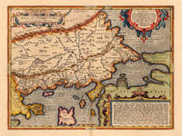
162416765Antwerp: Balthasar Moretus 1624. Other. A very good example in excellent condition. 360 by 480mm 14 by 19 inches. Original antique copper engraving published 1624 in the famous historical Atlas Parergon Latin text-edition by Abraham Ortelius. Finely hand colored in wash and outline. Fine and early historical map on Thracia. The area on this map covers mainly Thracia in Northern Greece and parts of Romania. The map is ornated with three cartouches in the upper left corner the title cartouche on the lower and upper right side we find text cartouches. Villages and towns are shown as miniature views. Ortelius was born on 14 April 1527 in the city of Antwerp which was then in the Habsburg Netherlands modern-day Belgium. The Orthellius family were originally from Augsburg a Free imperial city of the Holy Roman Empire. In 1535 the family had fallen under suspicion of Protestantism. Following the death of Ortelius's father his uncle Jacobus van Meteren returned from religious exile in England to take care of Ortelius. Abraham remained close to his cousin Emanuel van Meteren who would later moved to London. In 1575 he was appointed geographer to the king of Spain Philip II on the recommendation of Arias Montanus who vouched for his orthodoxy. He travelled extensively in Europe and is specifically known to have traveled throughout the Seventeen Provinces; in southern western northern and eastern Germany e.g. 1560 15751576; France 15591560; England and Ireland 1576; and Italy 1578 and perhaps twice or thrice between 1550 and 1558. Beginning as a map-engraver in 1547 he entered the Antwerp Guild of Saint Luke as an illuminator of maps. He supplemented his income trading in books prints and maps and his journeys included yearly visits to the Frankfurt book and print fair where he met Gerardus Mercator in 1554. In 1560 however when travelling with Mercator to Trier Lorraine and Poitiers he seems to have been attracted largely by Mercator's influence towards the career of a scientific geographer. Wikipedia Koe. Ort. 46; Balthasar Moretus unknown
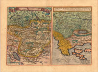
161213928Antwerp: Juan Baptist Vrients 1612. Other. In excellent condition. 340 by 500mm 13 by 19 inches. Original copper engraving published 1612 in the famous Vrients-edition of the Theatrum Orbis Terrarum. Finely hand-coloured in wash and outline. Two maps on one doublepage plate each one of them showing a title cartouche at the top centre. Villages and towns are shown as miniature views as well mountains and rivers are shown. The both maps are engraved after Wolfgang Lazius. This example is in very decorative colours and in excellent condition however the hand colour is probably done by a later hand. On the full sheet as published. The detailled map on the Duchy of Tirol is mainly showing South Tirol with the area Insbruck Trient the Lago de Garda towards Verona in the South. The other map is showing the area Carniola Istria and the so called "Windisch Mark". Ortelius was born on 14 April 1527 in the city of Antwerp which was then in the Habsburg Netherlands modern-day Belgium. The Orthellius family were originally from Augsburg a Free imperial city of the Holy Roman Empire. In 1535 the family had fallen under suspicion of Protestantism. Following the death of Ortelius's father his uncle Jacobus van Meteren returned from religious exile in England to take care of Ortelius. Abraham remained close to his cousin Emanuel van Meteren who would later moved to London. In 1575 he was appointed geographer to the king of Spain Philip II on the recommendation of Arias Montanus who vouched for his orthodoxy. He travelled extensively in Europe and is specifically known to have traveled throughout the Seventeen Provinces; in southern western northern and eastern Germany e.g. 1560 15751576; France 15591560; England and Ireland 1576; and Italy 1578 and perhaps twice or thrice between 1550 and 1558. Beginning as a map-engraver in 1547 he entered the Antwerp Guild of Saint Luke as an illuminator of maps. He supplemented his income trading in books prints and maps and his journeys included yearly visits to the Frankfurt book and print fair where he met Gerardus Mercator in 1554. In 1560 however when travelling with Mercator to Trier Lorraine and Poitiers he seems to have been attracted largely by Mercator's influence towards the career of a scientific geographer. Wikipedia Broe. 116 Juan Baptist Vrients unknown
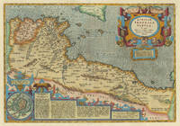
161230987Antwerp: Balthasar Moretus 1612. Other. In excellent condition. 338 by 488mm 13 by 19 inches. Original copper engraving published 1612 in the famous historical Atlas Parergon Latin text-edition by Abraham Ortelius. Finely later hand-colored in wash and outline. Very decorative map of North Africa Libya and Tunisia with Malta and southern Sicily.This map is ornated with a decorative title cartouche in the upper right corner and an inset with text cartouches in the lower left corner. Villages and towns are shown as miniature views. Ortelius was born on 14 April 1527 in the city of Antwerp which was then in the Habsburg Netherlands modern-day Belgium. The Orthellius family were originally from Augsburg a Free imperial city of the Holy Roman Empire. In 1535 the family had fallen under suspicion of Protestantism. Following the death of Ortelius's father his uncle Jacobus van Meteren returned from religious exile in England to take care of Ortelius. Abraham remained close to his cousin Emanuel van Meteren who would later moved to London. In 1575 he was appointed geographer to the king of Spain Philip II on the recommendation of Arias Montanus who vouched for his orthodoxy. He travelled extensively in Europe and is specifically known to have traveled throughout the Seventeen Provinces; in southern western northern and eastern Germany e.g. 1560 15751576; France 15591560; England and Ireland 1576; and Italy 1578 and perhaps twice or thrice between 1550 and 1558. Beginning as a map-engraver in 1547 he entered the Antwerp Guild of Saint Luke as an illuminator of maps. He supplemented his income trading in books prints and maps and his journeys included yearly visits to the Frankfurt book and print fair where he met Gerardus Mercator in 1554. In 1560 however when travelling with Mercator to Trier Lorraine and Poitiers he seems to have been attracted largely by Mercator's influence towards the career of a scientific geographer. Wikipedia Broe. 218 Koemann III map 8610H:31 ed. 31:051 1595 Latin Balthasar Moretus unknown
167760729Cologne i.e. Rouen Pierre du Marteau 1677 Ville-France Pierre Petit 1677. 8vo. In a contemporary vellum binding with yapp edges. Small paper-label pasted on to top of spine. Ex-libris pasted on to pasted down front end-paper. Previous owner's name in contemporary hand to title-page. Light wear to extremities otherwise nice and clean. 6 627 3 190 pp. hardcover
167760729Cologne (i.e. Rouen), Pierre du Marteau, 1677 (+) Ville-France, Pierre Petit, 1677. 8vo. In a contemporary vellum binding with yapp edges. Small paper-label pasted on to top of spine. Ex-libris pasted on to pasted down front end-paper. Previous owner's name in contemporary hand to title-page. Light wear to extremities, otherwise nice and clean. (6), 627, (3), 190 pp.
167210237Leiden: Hackius. Good with no dust jacket. 1672. Leather. 24 249 27 140 22 22 65 3 p. Engraved plate before the first title page. 12 mo. Completely bound in fine calf with blind ruling rectangular ruled lozenge with tulips at each corner spine has four raised bands spine label is no present. Spine ends a little rubbed corners a little rubbed end pages darkened otherwise paper is clean and unmarked with some foxing. One page has a flaw in the corner. Sewing showing at the various title pages. 4 works in one volume on rings their history in the ancient world text in Latin with some Greek. Corresponds to OCLC 863537511. Title to pt. 2 reads: "Georgii Longi sacerdotis doctoris & Ambrosianae Bibliothecae custodis primi Tractatus de annulis signatoriis antiquorum sive De vario obsignandi ritu"; title to pt. 3 reads "Abrahami Gorlaei Antwerpiani Dactyliotheca sive Tractatus de anulorum origine variis eorum generibus et usu apud priscos"; title to pt. 4 reads "De annulo triplici: usitato sponsalitio signatorio: tractatus absolutissimus in tres partes divisus. Auctore Henrico Kornmanno ex Kirchaina Chattorum." ; 12mo 7" - 7½" tall . Hackius hardcover
1637437671637 Rouen. Claude Le Villain. 1637. 1 volume petit in-8, plein vélin taché, dos lisse orné du nom de l’auteur en long, trace de lacets. (4) ff. ; 309 pp. ; (3) pp.
1684elala472Amsterdam & Paris: Frédéric Léonard 1684. 1684. 4to. pp. 24 p.l. 432 18index 2errata. woodcut printers device on title. woodcut ornaments & initials. contemporary mottled calf gilt back gilt arms on covers of Lepinette Le Mairat Baron de Lustrac Olivier 379 spine ends worn some moderate browning & foxing. Second Edition of this political discourse on Tacitus in which the French historian and publicist Amelot de la Houssaye gives an analysis the character of the Roman Emperor Tiberius. The work was originally published in 1683 under the pseudonym La Mothe-Josanvel. cfCioranescu 7110. Hardcover. Amsterdam & Paris: Frédéric Léonard, 1684. Hardcover
163555473Leiden:: Ex officina Elzeviriana 1635. later full vellum with red gilt-lettered spine labels. Aside from the repair to the engraved title a beautiful clean copy. 16mo. Engraved title page trimmed close to the platemark and laid down; five full-page woodcut illustrations; three folding maps; portrait medallion. . Ex officina Elzeviriana, hardcover
1603299306Antwerp: Abraham Ortelius 1603. unbound. Map. Engraving with beautiful original hand color. Image measures 14" x 18 3/4". Light staining and toning but otherwise is good condition.<br/><br/> A representation of some islands in the Mediterranean Sea. Abraham Ortelius 1527-1598 a Flemish cartographer and geographer is widely regarded as one of the important and influential cartographers in history. He is known for his "Theatrum Orbis Terrarum" which was the first modern atlas. Van den Broecke #141<br/><br/> Abraham Ortelius unknown books
1603299306Antwerp: Abraham Ortelius 1603. unbound. Map. Engraving with beautiful original hand color. Image measures 14" x 18 3/4". Light staining and toning but otherwise is good condition.<br/> <br/> A representation of some islands in the Mediterranean Sea. Abraham Ortelius 1527-1598 a Flemish cartographer and geographer is widely regarded as one of the important and influential cartographers in history. He is known for his "Theatrum Orbis Terrarum" which was the first modern atlas. Van den Broecke #141<br/> <br/> Abraham Ortelius unknown
1603228104Antwerp: Abraham Ortelius 1603. unbound. very good. Map. Engraving with original hand coloring. Image measures 13.25" x 18.25".<br/> <br/> Beautifully colored map of Croatia. Shows place names topographical and geographical features a compass rose and a ship in the Adriatic. Latin text on verso. From "Theatrum Orbis Terrarum". Light scattered stains to margins and cartouche. Minor abrasion to upper right. A few small chips and tears to edges. Abraham Ortelius 1527--1598 a Flemish cartographer and geographer is widely regarded as one of the important and influential cartographers in history. He is known for his "Theatrum Orbis Terrarum" which was the first modern atlas. Van den Broecke 145<br/> <br/> Abraham Ortelius unknown
162421830Antwerp: Balthasar Moretus 1624. Other. A very good example in excellent condition. 360 by 480mm 14 by 19 inches. Original copper engraving published 1624 in the famous historical Atlas Parergon Latin text-edition by Abraham Ortelius. Finely hand colored in wash and outline. Fine and early historical map on Thracia. The area on this map covers mainly Thracia in Northern Greece and parts of Romania. The map is ornated with three cartouches in the upper left corner the title cartouche on the lower and upper right side we find text cartouches. Villages and towns are shown as miniature views. Ortelius was born on 14 April 1527 in the city of Antwerp which was then in the Habsburg Netherlands modern-day Belgium. The Orthellius family were originally from Augsburg a Free imperial city of the Holy Roman Empire. In 1535 the family had fallen under suspicion of Protestantism. Following the death of Ortelius's father his uncle Jacobus van Meteren returned from religious exile in England to take care of Ortelius. Abraham remained close to his cousin Emanuel van Meteren who would later moved to London. In 1575 he was appointed geographer to the king of Spain Philip II on the recommendation of Arias Montanus who vouched for his orthodoxy. He travelled extensively in Europe and is specifically known to have traveled throughout the Seventeen Provinces; in southern western northern and eastern Germany e.g. 1560 15751576; France 15591560; England and Ireland 1576; and Italy 1578 and perhaps twice or thrice between 1550 and 1558. Beginning as a map-engraver in 1547 he entered the Antwerp Guild of Saint Luke as an illuminator of maps. He supplemented his income trading in books prints and maps and his journeys included yearly visits to the Frankfurt book and print fair where he met Gerardus Mercator in 1554. In 1560 however when travelling with Mercator to Trier Lorraine and Poitiers he seems to have been attracted largely by Mercator's influence towards the career of a scientific geographer. Wikipedia Koe. Ort. 46; Balthasar Moretus unknown
166955075London: Printed By J. M. For Henry Herringman 1669. Front board ffep and frontis detached but extant. Corners heavily bumped. Heavy loss to spine but title label remains albeit a little chipped. However remaining text block in good order sturdy and pages clean apart from the odd spot. Full Leather. Good Minus. 4to. Printed By J. M. For Henry Herringman Hardcover
167768020Chez Pierre du Marteau | à Cologne 1677 | 8.50 x 14 cm | relié
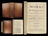
1671328857London : Printed by J.M. for Henry Herringman at the Sign of the Blue Anchor in the Lower Walk of the New Exchange 1671. 1st edition. Hardcover. Provenance: Bookplate of John Walker Heneage. Good copy in the original full tree calf with a gilt-blocked label to the spine. Raised bands. Lacks title page. Some wear and tear to the spine bands and panel edges. Remains well-preserved overall. Date is suggested. Physical description: 42 41 1 80 4 58 61-70 154 23 1 148 p. 1 leaf of plates : front. port.; 31 cm. fol. Notes: ""The mistress"" ""Pindarique odes"" and ""Davideis a sacred poem"" each have separate dated title pages and pagination; register is continuous. Includes ""An account of the life and writings of Cowley"" signed: T. Sprat. Subjects: Cowley Abraham 1618-1667. English poetry 17th century.English prose literature 17th century. Satire English 17th century. Love; Poetry; Early works to 1800. London : Printed by J.M. for Henry Herringman, at the Sign of the Blue Anchor in the Lower Walk of the New Exchange hardcover
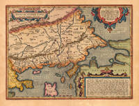
1610M1953Antwerp c.1610. Very Good. Notes: Rare Cartographer Portantius Latin text on verso Size : 227x250 mm 8.875x9.875 Inches Coloring: Hand Colored Category: Maps Europe Estonia Latvia; unknown
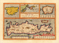
161213729Antwerp: Juan Baptist Vrients 1612. Other. In excellent condition. 342 by 491mm 13 by 19 inches. Original antique copper engraving decorative hand colored. Published 1612 in the historical Atlas "Parergon" by Abraham Ortelius bound with his famous Theatrum Orbis Terrarum. Finely hand-colored in wash and outline. Four maps on one plate: Corsica the Ionian Islands Cephalonia Zacynthus Corcyra Sardinia and Crete. Villages and towns are shown as miniature views moreover the map at the bottom is ornated with ships sea monsters and animals. At the bottom we find two cartouches with listings of antique place names and explanations. A very good example in excellent condition. Ortelius was born on 14 April 1527 in the city of Antwerp which was then in the Habsburg Netherlands modern-day Belgium. The Orthellius family were originally from Augsburg a Free imperial city of the Holy Roman Empire. In 1535 the family had fallen under suspicion of Protestantism. Following the death of Ortelius's father his uncle Jacobus van Meteren returned from religious exile in England to take care of Ortelius. Abraham remained close to his cousin Emanuel van Meteren who would later moved to London. In 1575 he was appointed geographer to the king of Spain Philip II on the recommendation of Arias Montanus who vouched for his orthodoxy. He travelled extensively in Europe and is specifically known to have traveled throughout the Seventeen Provinces; in southern western northern and eastern Germany e.g. 1560 15751576; France 15591560; England and Ireland 1576; and Italy 1578 and perhaps twice or thrice between 1550 and 1558. Beginning as a map-engraver in 1547 he entered the Antwerp Guild of Saint Luke as an illuminator of maps. He supplemented his income trading in books prints and maps and his journeys included yearly visits to the Frankfurt book and print fair where he met Gerardus Mercator in 1554. In 1560 however when travelling with Mercator to Trier Lorraine and Poitiers he seems to have been attracted largely by Mercator's influence towards the career of a scientific geographer. Wikipedia Broe. 217 Juan Baptist Vrients unknown
161213895Antwerp: Vrients 1612. Other. In excellent condition. 372 by 503mm 14 by 19 inches. Original antique copper engraving published 1612 in a Italian text edition of the " Theatrum Orbis Terrarum. Uncolored example in a strong impression. The map is ornated with a title cartouche in the lower right corner naming the autor "Christian Schrot" on whom Abraham Ortelius based his cartographic source for this map in his atlas. Top left corner with a small mileage scale. For the decoration of the map we find a sailing ship in the "Zuyder Zee". Ortelius was born on 14 April 1527 in the city of Antwerp which was then in the Habsburg Netherlands modern-day Belgium. The Orthellius family were originally from Augsburg a Free imperial city of the Holy Roman Empire. In 1535 the family had fallen under suspicion of Protestantism. Following the death of Ortelius's father his uncle Jacobus van Meteren returned from religious exile in England to take care of Ortelius. Abraham remained close to his cousin Emanuel van Meteren who would later moved to London. In 1575 he was appointed geographer to the king of Spain Philip II on the recommendation of Arias Montanus who vouched for his orthodoxy. He travelled extensively in Europe and is specifically known to have traveled throughout the Seventeen Provinces; in southern western northern and eastern Germany e.g. 1560 15751576; France 15591560; England and Ireland 1576; and Italy 1578 and perhaps twice or thrice between 1550 and 1558. Beginning as a map-engraver in 1547 he entered the Antwerp Guild of Saint Luke as an illuminator of maps. He supplemented his income trading in books prints and maps and his journeys included yearly visits to the Frankfurt book and print fair where he met Gerardus Mercator in 1554. In 1560 however when travelling with Mercator to Trier Lorraine and Poitiers he seems to have been attracted largely by Mercator's influence towards the career of a scientific geographer. Wikipedia Broe. 61. State 3/4. Vrients unknown
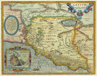
161230976Antwerp: Balthasar Moretus 1612. Other. In excellent condition. 356 by 453mm 14 by 17 inches. Original antique copper engraving from the 'Theatrum Orbis Terrarum' by Abraham Ortelius the world's first modern atlas published in Antwerp 1612. Depicting Rome & Latium this map is a fine example of 1610s European cartography. Image: 356 by 453mm 14 by 17 inches. An attractive and historically significant 17th-century map for the discerning collector. Abraham Ortelius 15271598 was a Flemish cartographer and geographer born in Antwerp. He is widely regarded as the creator of the first modern atlas the 'Theatrum Orbis Terrarum' Theatre of the World first published in 1570 by Gilles Coppens de Diest in Antwerp. Considered the world's first true atlas it established the modern format of uniform standardized maps bound together in a single volume. Appointed Geographer to King Philip II of Spain in 1575 Ortelius was one of the most influential figures in the history of cartography. His maps are held in the collections of the British Library the Library of Congress and major European institutions. The 'Theatrum' went through more than 30 editions and was translated into multiple languages making Ortelius's maps among the most sought-after in the world of antique cartography.The map is ornated with three cartouches in the upper left corner the title cartouche on the upper right side we find an oval text cartouche and in the lower left corner an inset. The privilegium is written on the lower right side. Villages and towns are shown as miniature views. Moreover the map is ornated with a ship.A fine example from Theatrum Orbis Terrarum Antwerp sought after by collectors of antique maps of Italy antique maps of Rome and antique copper engravings for sale. In good condition consistent with age. Light age-toning to the sheet as expected for a 17th-century engraving. Centerfold as published. Koe. Ort. 46; Broe: 209 state 2/2; Balthasar Moretus unknown
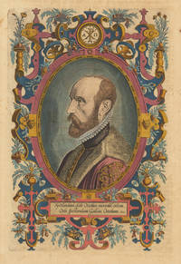
161230060Antwerp: Vrients 1612. Other. In exellent condition. 318 by 209mm 12 by 8 inches. Original antique copper engraving later hand colored. Latin text edition. This is the beautiful hand colored portrait of Abraham Ortelius as frontispiece to his "Theatrum Orbis". Engraved by Phillipe Galle. Ortelius was born on 14 April 1527 in the city of Antwerp which was then in the Habsburg Netherlands modern-day Belgium. The Orthellius family were originally from Augsburg a Free imperial city of the Holy Roman Empire. In 1535 the family had fallen under suspicion of Protestantism. Following the death of Ortelius's father his uncle Jacobus van Meteren returned from religious exile in England to take care of Ortelius. Abraham remained close to his cousin Emanuel van Meteren who would later moved to London. In 1575 he was appointed geographer to the king of Spain Philip II on the recommendation of Arias Montanus who vouched for his orthodoxy. He travelled extensively in Europe and is specifically known to have traveled throughout the Seventeen Provinces; in southern western northern and eastern Germany e.g. 1560 15751576; France 15591560; England and Ireland 1576; and Italy 1578 and perhaps twice or thrice between 1550 and 1558. Beginning as a map-engraver in 1547 he entered the Antwerp Guild of Saint Luke as an illuminator of maps. He supplemented his income trading in books prints and maps and his journeys included yearly visits to the Frankfurt book and print fair where he met Gerardus Mercator in 1554. In 1560 however when travelling with Mercator to Trier Lorraine and Poitiers he seems to have been attracted largely by Mercator's influence towards the career of a scientific geographer. Wikipedia Vrients unknown
170026491<p><strong>1700 Abraham Cowley ENGLISH Poetry Mistress Motto Pindar Ode Davideis FOLIO</strong></p><p><em>"What shall I do to be for ever known</em></p><p><em>And make the Age to come own"</em></p><p><em>I shall like beasts or common people die </em></p><p><em> Unless you write my elegy." </em>– Abraham Cowley <em>The Motto</em></p><p>Abraham Cowley was one of the leading English poets during the 17th-century. Famous poems such as '<em>The Motto</em>' '<em>The Mistress</em>' '<em>Ode to Pindar</em>' and '<em>Davideis'</em> are all included in this collection. The <em>Pindaric Ode</em> is especially interesting in that Cowley attempted to reproduce Pindar's works but in doing so he misinterpreted the metrical patterns and in doing so did not accurately reflect Pindar's poetry. He did however create one of the most famous odes ever written which would become the influence for William Wordsworth's famous ode<em> "Intimations of Immortality."</em></p><p>Item number: #26491</p><p>Price: $499</p><p>COWLEY Abraham</p><p><strong><em>The works of Mr. Abraham Cowley: consisting of those which were formerly printed and those which be design'd for the press</em></strong></p><p>London: Printed by J.M. for Henry Herringman. 1700.</p><p><u>Details</u>: </p><p><!-- if !supportLists-->· <!--endif-->Collation: Complete; 3 parts in 1</p><p><!-- if !supportLists-->o <!--endif-->Works Part 1 – 34 94</p><p><!-- if !supportLists-->o <!--endif-->Ode of Pindar / Davideis / Discourses – 4 56; 127 i.e. 125 1; 129</p><p><!-- if !supportLists-->o <!--endif-->Cutter – 4 32 4</p><p><!-- if !supportLists-->o <!--endif-->Works Part 2 – 16 161 1</p><p><!-- if !supportLists-->o <!--endif-->Works Part 3 – 20 166 2</p><p><!-- if !supportLists-->o <!--endif-->Pagination errors expected</p><p><!-- if !supportLists-->· <!--endif-->References: Lowndes 539; Perkin B 7.</p><p><!-- if !supportLists-->· <!--endif-->Language: English</p><p><!-- if !supportLists-->· <!--endif-->Binding: Leather; tight and secure</p><p><!-- if !supportLists-->· <!--endif-->Size: ~12in X 8.5in 30.5cm x 21.5cm</p><p>Our Guarantee:</p><p>Very Fast. Very Safe. Free Shipping Worldwide.</p><p>Customer satisfaction is our priority! Notify us with 7 days of receiving and we will offer a full refund without reservation!</p><p>26491</p><p>Photos available upon request. </p> J.M. for Henry Herringman hardcover
167736147Sur la Copie a Paris: Chez Frederic Leonard 1677. Second French edition. Engraved title two parts continuous pagination. 24 550 38 pp. 1 vols. Sm. 12mo. Vellum. Title in pen on spine upper joint torn some soiling of binding light browning of text mostly marginal else a very good copy. Second French edition. Engraved title two parts continuous pagination. 24 550 38 pp. 1 vols. Sm. 12mo. Amelot de la Houssaye was secretary to the French embassy at Venice and his account of the Republic for the first time revealed the policy of the Venetian governement. When the book appeared the Venetian state complained to the French court and Amelot was sent to the Bastille for six weeks. Chez Frederic Leonard unknown
167719726Paris: Frederic Leonard 1677. 16mo. Engr. t.-p. 6 1 pp. 7 6 ff. 211 3 pp. 1 f. 550 pp. 19 ff. 237 3 pp. <br><br>The main title-page is engraved with the title printed above the illustration.<br>Â Â Â Â There are special title-pages and paginations for "Examen de la liberté originaire de Venise. Traduit de l'Italien. Avec une Harangue de Louïs Hïlian . Traduite du Latin. Et des Remarques Historiques. Sur la copie a Ratisbonne Chez J. Aubri . 1677"; "Histoire du gouvernement de Venise avec le supplement; par le sieur Amelot de la Houssaie. Et l'examen de la Liberté originaire de Venise. Sur la copie a Paris; Chez Frederic Leonard . 1677"; and "Suplement a l'Histoire du gouvernement de Venise. Par le sieur Amelot de La Houssaie. Sur la copie a Paris chez Frederic Leonard . 1677."<br>Â Â Â Â "Examen de la liberté originaire de Venise" is a translation by Amelot de La "Houssaye of Squitinio della liberta veneta" which is attributed to Marcus Welser Alfonso de la Cueva and others. Contemporary calf modest gilt tooling on covers spine tooled in blind and with raised bands. Leather cracking and with thumbnail-sized chip on spine; some loss of leather on front cover and at head and foot of spine; and front joint starting. Bookplate on front pastedown and a couple of ink notations by an early owner at bottom of engraved title-page. Endpapers with heavy brown stains along edges but pages overall clean. Frederic Leonard hardcover books