23 962 résultats
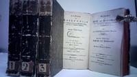
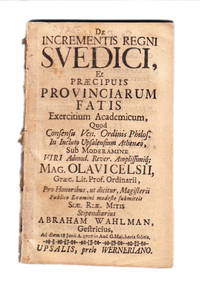
87998Uppsala Werneriano 1707. 8:o. 8 110 pp. Disbound. Lidén I p. 97. Warmholtz 217. Not in Sabin. A dissertation about the Swedish provinces abroad and it colonies. Deals with Livonia Courland the swedish parts of Germany and it describes the battles with Denmark concerning Scania and Gotland. It also contains a chapter about the swedish inhabitants in New Sweden in America. unknown
2019x-9811319502Springer-Verlag New York Inc 2019. Paperback. New. 861 pages. 9.00x6.00x1.75 inches. Springer-Verlag New York Inc paperback
2023x-3031275233Springer Nature 2023. Paperback. New. 932 pages. 9.25x6.10x1.84 inches. Springer Nature paperback
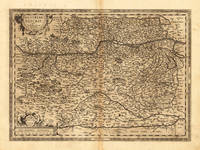
159817608Antwerp: Platin 1598. Other. In excellent condition. 356 by 486mm 14 by 19 inches. Original antique copper engraving published 1598 in a French text edition of the " Theatrum Orbis Terrarum. Uncolored example in a strong impression as published. This is the second plate of the Austria map after Wolfgang Lazius published for the first time in the "Theatrum Orbis Terrarum" after 1595. Here present in the 1598 edition. A highly decorative early map of the duchy of Austria towns are still shown as miniature engraved city views mountains woods rivers and lakes are decorative engraved. In the lower right corner a milage scale with a coat of arms. In the center of the map we find Vienna. The map reaches in the west from Linz towards the Neusiedler lake in the east. In the south with the neighbouring Carintia and Salzburg. Ortelius was born on 14 April 1527 in the city of Antwerp which was then in the Habsburg Netherlands modern-day Belgium. The Orthellius family were originally from Augsburg a Free imperial city of the Holy Roman Empire. In 1535 the family had fallen under suspicion of Protestantism. Following the death of Ortelius's father his uncle Jacobus van Meteren returned from religious exile in England to take care of Ortelius. Abraham remained close to his cousin Emanuel van Meteren who would later moved to London. In 1575 he was appointed geographer to the king of Spain Philip II on the recommendation of Arias Montanus who vouched for his orthodoxy. He travelled extensively in Europe and is specifically known to have traveled throughout the Seventeen Provinces; in southern western northern and eastern Germany e.g. 1560 15751576; France 15591560; England and Ireland 1576; and Italy 1578 and perhaps twice or thrice between 1550 and 1558. Beginning as a map-engraver in 1547 he entered the Antwerp Guild of Saint Luke as an illuminator of maps. He supplemented his income trading in books prints and maps and his journeys included yearly visits to the Frankfurt book and print fair where he met Gerardus Mercator in 1554. In 1560 however when travelling with Mercator to Trier Lorraine and Poitiers he seems to have been attracted largely by Mercator's influence towards the career of a scientific geographer. Wikipedia Broe. 106 Platin unknown
157221923Antwerpen 1572 - 73. Other. In very good to excellent condition. 370 by 500mm 14 by 19 inches. Original antique copper engraving hand colored in outline when published. Decorative map of Ortelius" first plate covering Gelderland. Based on Christiaan Sgrothen" s map of 1567 and is richly engraved with fine detail particularly along the rivers. The map is oriented with north to the left with ribbon cartouches marking the cardinal directions. Two ships sail in the Zuyder Zee and a decorative cartouche with flowers and birds. Ortelius was born on 14 April 1527 in the city of Antwerp which was then in the Habsburg Netherlands modern-day Belgium. The Orthellius family were originally from Augsburg a Free imperial city of the Holy Roman Empire. In 1535 the family had fallen under suspicion of Protestantism. Following the death of Ortelius's father his uncle Jacobus van Meteren returned from religious exile in England to take care of Ortelius. Abraham remained close to his cousin Emanuel van Meteren who would later moved to London. In 1575 he was appointed geographer to the king of Spain Philip II on the recommendation of Arias Montanus who vouched for his orthodoxy. He travelled extensively in Europe and is specifically known to have traveled throughout the Seventeen Provinces; in southern western northern and eastern Germany e.g. 1560 15751576; France 15591560; England and Ireland 1576; and Italy 1578 and perhaps twice or thrice between 1550 and 1558. Beginning as a map-engraver in 1547 he entered the Antwerp Guild of Saint Luke as an illuminator of maps. He supplemented his income trading in books prints and maps and his journeys included yearly visits to the Frankfurt book and print fair where he met Gerardus Mercator in 1554. In 1560 however when travelling with Mercator to Trier Lorraine and Poitiers he seems to have been attracted largely by Mercator's influence towards the career of a scientific geographer. Wikipedia Koe. Ort 1C / 15. Broe. 61. 1 of 2. unknown
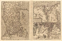
157223534Antwerp: Platin 1572/73. Other. In excellent condition. 321 by 492mm 12 by 19 inches. Original copper engraving uncolored as published 1572/73 in a German text edition of the " Theatrum Orbis Terrarum. The map shows three maps on one double page each of them with a title cartouche. Asia Minor is shown with the east to the north oriented with Cyprus in the eastern Mediterranean. The other small map of Egypt is showing mainly the Nile delta with the neighboring area. The third map shows the surroundings of Tunis Carthago. Villages and towns are shown as miniature views. Moreover the maps are ornated with ships. Abraham Ortelius received the cartographic sources for those maps by Gastaldi and Forlani 1564 for Egypt by Forlani 1566 and Carthago after an Italian one sheet source dated 1535 Broe. 174. Ortelius was born on 14 April 1527 in the city of Antwerp which was then in the Habsburg Netherlands modern-day Belgium. The Orthellius family were originally from Augsburg a Free imperial city of the Holy Roman Empire. In 1535 the family had fallen under suspicion of Protestantism. Following the death of Ortelius's father his uncle Jacobus van Meteren returned from religious exile in England to take care of Ortelius. Abraham remained close to his cousin Emanuel van Meteren who would later moved to London. In 1575 he was appointed geographer to the king of Spain Philip II on the recommendation of Arias Montanus who vouched for his orthodoxy. He travelled extensively in Europe and is specifically known to have traveled throughout the Seventeen Provinces; in southern western northern and eastern Germany e.g. 1560 15751576; France 15591560; England and Ireland 1576; and Italy 1578 and perhaps twice or thrice between 1550 and 1558. Beginning as a map-engraver in 1547 he entered the Antwerp Guild of Saint Luke as an illuminator of maps. He supplemented his income trading in books prints and maps and his journeys included yearly visits to the Frankfurt book and print fair where he met Gerardus Mercator in 1554. In 1560 however when travelling with Mercator to Trier Lorraine and Poitiers he seems to have been attracted largely by Mercator's influence towards the career of a scientific geographer. Wikipedia Broe. 174. Platin unknown
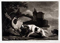
177814190London: Published by J. Watts Dealer in Prints & Drawings opposite the Mews Gate Charing Cross 1778. Mezzotints. Printed on laid watermarked paper. In excellent condition. Morning Image size: 9 1/2 x 13 7/8 inches. Plate mark: 10 x 13 7/8 inches. Sheet size: 10 5/8 x 14 7/8 inches. Evening Image size: 9 3/8 x 13 7/8. Plate mark: 9 7/8 x 13 7/8. Sheet size: 10 3/4 x 15 1/8 inches. This is a stunning pair of mezzotints of two hunting dogs catching their quarry by John Watts after paintings by Abraham Hondius.<br/> <br/> Watts was a successful printmaker and publisher who was active in London during the second half of the eighteenth century. He was famed for his rich mezzotints which he exhibited in London between 1766 and 1778. Watts scraped mezzotints after some of the most renowned artists of his day but he had a special penchant for works by the Dutch masters such as this handsome pair after Abraham Hondius the celebrated Dutch animal painter. These rich mezzotints are a superb example of Watts's luxurious style of engraving translating the energy and fluidity of Hondius's beautiful paintings into a dramatic example of superior mezzotint engraving.<br/> <br/> Benezit Dictionnaire Des Peintres Sculpteurs Dessinateurs et Graveurs. Published by J. Watts, Dealer in Prints & Drawings opposite the Mews Gate Charing Cross unknown
ria9781315893464_inpHardcover. New. New Book; Fast Shipping from UK; Not signed; Not First Edition; These volumes are an exhaustive source of information on the control and regulation of flowering. Individual species are described from the standpoint of juvenility and maturation morphology induction and morphogenesis to anthesis. Al hardcover
#[60354]Half length portrait of Erasmus of Rotterdam in elaborated oval frame with caduceus and shield with Medusa's head. Inscription on plynth below:' DESIDERIO ERASMO / ROTTERODAMO. / Effigiem Desiderii qui cernis Erasmi / Humano quiddam grandius ore vides. / Perlege Scriptoris divina volumina magni / Coelesti dices scripta fuisse manu. / Doctrinam eloquium pietatem singula spirat / Pagina: nec quicquam tersius esse potest. / Ardua qui studiis et seria junxit amoenis / Utile qui dulci miscuit; ille fuit / Editus ad Mosam Rheni delatus ad amnem / Praeposuit patriae te Basilea suae. / Terra Virum repetit post mortem Belgica; jamque / Nascitur in Batavo rursus ut ante solo. / Petrus Francius'. In 'Desiderii Erasmi Roterodami Opera omnia emendatiora et auctiora . in decem tomos distincta.' Leiden: Pieter van der Aa 1703. l Engraving on paper with margins; platemark: 413 x 301 mm; total: 453 x 335 mm; few tiny holes some dirt on the left margin. W 20; M 1493. PP02E Erasmus unknown
2023x-3031355091Springer Nature 2023. Paperback. New. 632 pages. 9.25x6.10x1.28 inches. Springer Nature paperback
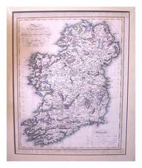
1820ZB1345722Philadelphia: Samuel F. Bradford 1820. Price HAS BEEN REDUCED by 10% until Monday June 29 SALE item 22 double-page plates actually 21 with Tab. 15 & 16 together on the same sheet plus 38 double-page maps of the modern world and the large folding map of the United States of America for a total of 61 actually 60 plates; contemporary full leather covers worn and dry moderate to heavy foxing to the plates. - If you are reading this this item is actually physically in our stock and ready for shipment once ordered. We are not bookjackers. Buyer is responsible for any additional duties taxes or fees required by recipient's country. Photos available upon request. Philadelphia: Samuel F. Bradford hardcover
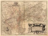
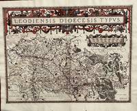
1584675Antwerp: Abraham Ortelius 1584. 19 1/2 x 14 2/4 inches. Very good condition. Ortelius was mentored by Mercator. The friendship yielded a mapmaking enterprise of great success. This map of the diocese of Liege. The main cartouche spreads across and covers the entire 2 pages. There is a secondary mileage cartouche scale. There is a major river through Liege. The Meuse runs thrash the map with primal impact showing the riverine regime as important to a large area. There is a multitude of small towns colored red. This is a very good copy with color not applied at publication. Ortelius oriented the west at the top of the map. Abraham Ortelius unknown
1814B2332London: Robert Baldwin 1814. A very good and attractive set. Binding: contemporary ½ calf with marbled boards spine with 6 densely gilt compartments of raised bands black morocco label on two and three all edges speckled. Size: 8vo Volume: 3 Pages: Volume 1. P. title blank v-xxxii 1-416; Volume 2. P. title blank v-viii 1-403; Volume 3. P. title blank v-viii 1-391 printer’s imprint. Category: Book Classics; Book Literature Robert Baldwin hardcover
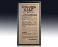
1905148440LaRue County Kentucky August 28 1905. Rare original broadside advertisement of the bankruptcy sale of Abraham Lincoln's birthplace The Lincoln Spring Farm. One page printed broadside advertisement by L.B. Handley Special Commissioner of the LaRue County Kentucky and dated August 28 1905. The headline states "Commissioner's Sale! Of the Abraham Lincoln Birthplace." Thomas and Nancy Lincoln moved into the home in December 1808 just weeks before the birth of their son Abraham in February 1809. Only a few bidders participated and the auction was won for $3600 by a representative of Robert Collier publisher of Collier's Weekly. Other interested parties included William Jennings Bryan Samuel Gompers and Mark Twain. It was Collier who established the Lincoln Farm Association and beyond the purchase of the farm in Kentucky was instrumental in establishing the Lincoln Memorial in Washington rendering this an important stop in the nation's recognition of the life of Abraham Lincoln. In near fine condition with toning and a few small losses to the edges. Framed. The entire piece measures 12.5 inches by 23.75 inches. Abraham Lincoln served as the 16th President of the United States from March 1861 until his assassination in April 1865. He led the United States through its Civil War and in doing so preserved the Union of the United States of America abolished slavery and strengthened the federal government. In his Address at the Sanitary Fair in Baltimore Maryland in April of 1861 Lincoln stated: “The world has never had a good definition of the word liberty and the American people just now are much in want of one. We all declare for liberty; but in using the same word we do not all mean the same thing. With some the word liberty may mean for each man to do as he pleases with himself and the product of his labor; while with others the same word may mean for some men to do as they please with other men and the product of other men’s labor. Here are two not only different but incompatible things called by the same name liberty. And it follows that each of the things is by the respective parties called by two different and incompatible names…liberty and tyranny.†unknown
194317167Recovery Inc. Good. 1943. First Edition. Hardcover. Crudely bound together in card covers. Contents are "fine". ; 8vo 8" - 9" tall; 138128 pages . Recovery, Inc. hardcover
1590M3046Antwerp 1590. Very Good; left and lower margins extended. Size : 233x100 mm 9.125x3.875 Inches Coloring: Original Hand Coloring Category: ; Maps Europe Greece Macedonia unknown
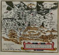
1574M8062Belgium c.1574. Very Good. Size : 220x246 mm 8.66x9.69 Inches Coloring: Hand Colored Category: Maps Europe Poland Lithuania; unknown
1610M1953Antwerp c.1610. Very Good. Notes: Rare Cartographer Portantius Latin text on verso Size : 227x250 mm 8.875x9.875 Inches Coloring: Hand Colored Category: Maps Europe Estonia Latvia; unknown
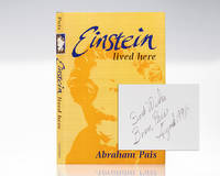
1994149772Oxford/New York: Clarendon Press/Oxford University Press 1994. First edition of this historical meditation and scientific commentary on Albert Einstein. Octavo original publisher's cloth frontispiece illustrated with black and white photographs throughout. Signed by the author on the front free endpaper "Best Wishes Bram Pais August 1996." Near fine in a fine dust jacket. Front cover illustration by Will Shaman. Uncommon signed. 'Einstein Lived Here' 1994 by Abraham Pais is a concise yet richly informed collection of essays that brings together biographical reflection scientific exposition and cultural history to illuminate Albert Einstein’s life and intellectual context. Pais—himself a distinguished physicist and one of Einstein’s most authoritative biographers—combines personal familiarity with archival scholarship to trace Einstein’s scientific achievements alongside the political and moral dilemmas that shaped his public role in the twentieth century. "'Einstein Lived Here' is the ideal Einstein book for non-physicists - a collection of charming sketches that brings Einstein to life in a variety of relationships" Arthur Schlesinger Jr. Pulitzer Prize-winning historian. Clarendon Press/Oxford University Press hardcover
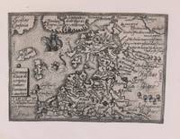
1579M8772Antwerp c. 1579. Margins are trimmed closely and laid on 19th century paper. Otherwise very good. . Notes: Map of Baltic region and Poland from the late 16th century with decorative border with sea monsters and tall ships. Size : 80x107 mm 3.15x4.21 Inches Coloring: Black & White Category: Maps Europe Estonia Latvia; Maps Europe Poland Lithuania; unknown
2023x-3031274393Springer Nature 2023. Paperback. New. 592 pages. 9.25x6.10x1.21 inches. Springer Nature paperback
1671328857London : Printed by J.M. for Henry Herringman at the Sign of the Blue Anchor in the Lower Walk of the New Exchange 1671. 1st edition. Hardcover. Provenance: Bookplate of John Walker Heneage. Good copy in the original full tree calf with a gilt-blocked label to the spine. Raised bands. Lacks title page. Some wear and tear to the spine bands and panel edges. Remains well-preserved overall. Date is suggested. Physical description: 42 41 1 80 4 58 61-70 154 23 1 148 p. 1 leaf of plates : front. port.; 31 cm. fol. Notes: ""The mistress"" ""Pindarique odes"" and ""Davideis a sacred poem"" each have separate dated title pages and pagination; register is continuous. Includes ""An account of the life and writings of Cowley"" signed: T. Sprat. Subjects: Cowley Abraham 1618-1667. English poetry 17th century.English prose literature 17th century. Satire English 17th century. Love; Poetry; Early works to 1800. London : Printed by J.M. for Henry Herringman, at the Sign of the Blue Anchor in the Lower Walk of the New Exchange hardcover
CBS 9781788824859USA Edition . New. Brand New! Fast Delivery US Edition and ship within 24-48 hours. Deliver by FedEx and Dhl & Aramex UPS & USPS and we do accept APO and PO BOX Addresses. Order can be delivered worldwide within 6-10 days and we do have flat rate for up to 2LB. Extra shipping charges will be requested if the Book weight is more than 5 LB. This Item May be shipped from India United states & United Kingdom. Depending on your location and availability. unknown
9a1038Johann Georg Rosenbusch Verlag Göttingen 1796-1800. X/708/XIV/759/XIV/484/XIV/516 S. Pappbände der Zeit berieben und bestossen/etwas fleckig. - Geschichte der Künste und Wissenschaften Abteilung VII Bände I-IV. Poggendorff I 1217. Erlecke 4. Bestermann III 3715/Erste Ausgabe "Keine eigentliche Geschichte der Mathematik sondern vielmehr eine chronologische Übersicht und innere wie äußere Analyse der mathematischen Literatur."Erlecke"Verdienstvoll. liefert eine Fülle von biographisch und kulturgeschichtlich interessanten Einzelheiten." NDB X 735/gutes Exemplar - unknown
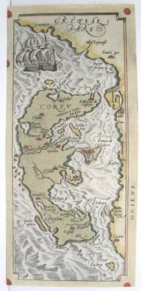
1753Europe: Antverpiæ"/Antwerp. "ex Officiana Plantiana" . Plantijn Christoffel. 1595. Copper engraved map of Ancient Crete from "The Parergon " of Ortelius' "Theatrum Orbis Terrarum" 1595 edition; black & white. Latin text to verso. The map shows Ancient Crete in the lower half with 3 smaller maps above of Corsica the Ionian Islands & Sardina in ancient times. Good dark impression. Abraham Ortelius 1527-1598 Flemish Cartographer . produced the first modern Atlas "Theatrum Orbis Terrarum" in 1570. printed by Aegidus Coppen Diest. There were numerous editions thereafter with texts in various languages; the printing of such was taken over by Chrstoffel Plantijn in 1579 . Ortelius himself drew all the maps in manuscript before passing them to the printers. there is conjecture that he may have engraved some of the plates as well The 1595 Latin text edition is the most complete produced during his lifetime containing all the maps of the 1593 edition plus those of the the"Additamentum" and the"Pareragon" or Ancient geography. The " Additamenta" were supplements to the original Atlas; at the same time Ortelius replaced some maps with new ones showing the same place; some plates were also reworked . Ortelius was Geographer Royal To Phillip II of Spain from 1575. He also worked closely with Braun & Hogenburg on the "Civitas Orbis Terarum". After his death the plates were purchased by Jan Baptiste Vrients in 1601 who published further editions until 1612. Van de Krogt :3; .Koeman: Ort29 V 7P; Zacherakis: 2504/1621; van den Broecke:217. Europe Greece Crete Ionian islands Sardinia Corsica Antverpiæ"/Antwerp.. "ex Officiana Plantiana" . Plantijn Christoffel.. 1595 unknown