255 résultats
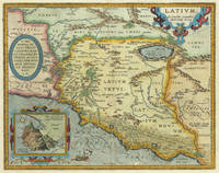
16247958Antwerp: Plantin-Moretus 1624. Copper engraving 32.5 x 48 cms modern hand colour Latin text on verso. Latium the hinterland of ancient Rome. Van den Broecke notes a minor change in nomenclature which was made for the 1624 edition 209.3 which is not present here although our example was published by Balthasar Moretus at the Plantin Press in the final edition of the Parergon. Ortelius's Theatrum Orbis Terrarum is generally considered the first modern atlas of the world originally published in 1570. Ortelius gathered and selected the best available cartographic knowledge and presented it in a single volume duly credited and finely engraved in a consistent style with explanatory text. The Theatrum was very decorative and hugely popular amongst the wealthy and educated running into over forty editions in Latin and the major European languages. For Ortelius himself however his accompanying atlas of ancient geography the Parergon was a "personal work" Koeman. He seems to have regarded himself first and foremost as an antiquary and rather than copying other people's maps he drew the originals himself; they were subsequently engraved for him by the master engraver Jan Wierix. The results have to be evaluated as the most outstanding engravings depicting the wide-spread interest in classical geography in the 16th century Koeman. Koeman Atlantes Neerlandici Ort 46. Van den Broecke 209.2 Map Plantin-Moretus unknown
161230976Antwerp: Balthasar Moretus 1612. Other. In excellent condition. 356 by 453mm 14 by 17 inches. Original antique copper engraving from the 'Theatrum Orbis Terrarum' by Abraham Ortelius the world's first modern atlas published in Antwerp 1612. Depicting Rome & Latium this map is a fine example of 1610s European cartography. Image: 356 by 453mm 14 by 17 inches. An attractive and historically significant 17th-century map for the discerning collector. Abraham Ortelius 15271598 was a Flemish cartographer and geographer born in Antwerp. He is widely regarded as the creator of the first modern atlas the 'Theatrum Orbis Terrarum' Theatre of the World first published in 1570 by Gilles Coppens de Diest in Antwerp. Considered the world's first true atlas it established the modern format of uniform standardized maps bound together in a single volume. Appointed Geographer to King Philip II of Spain in 1575 Ortelius was one of the most influential figures in the history of cartography. His maps are held in the collections of the British Library the Library of Congress and major European institutions. The 'Theatrum' went through more than 30 editions and was translated into multiple languages making Ortelius's maps among the most sought-after in the world of antique cartography.The map is ornated with three cartouches in the upper left corner the title cartouche on the upper right side we find an oval text cartouche and in the lower left corner an inset. The privilegium is written on the lower right side. Villages and towns are shown as miniature views. Moreover the map is ornated with a ship.A fine example from Theatrum Orbis Terrarum Antwerp sought after by collectors of antique maps of Italy antique maps of Rome and antique copper engravings for sale. In good condition consistent with age. Light age-toning to the sheet as expected for a 17th-century engraving. Centerfold as published. Koe. Ort. 46; Broe: 209 state 2/2; Balthasar Moretus unknown
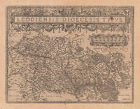
161220662Antwerp: Juan Baptist Vrints 1612. Other. Within the title cartouche an old small rust spot. In very good to excellent condition. 380 by 497mm 15 by 19 inches. Original antique copper engraving published 1612 in a Italian text edition Vriens edition of the " Theatrum Orbis Terrarum. This antique map shows the region of Lüttich in Belgium. The map is equipped with many small place names rivers woods etc. Uncolored copy in a strong impression. The map is ornated a large title cartouche and below a decorative mileage scale. Ortelius was born on 14 April 1527 in the city of Antwerp which was then in the Habsburg Netherlands modern-day Belgium. The Orthellius family were originally from Augsburg a Free imperial city of the Holy Roman Empire. In 1535 the family had fallen under suspicion of Protestantism. Following the death of Ortelius's father his uncle Jacobus van Meteren returned from religious exile in England to take care of Ortelius. Abraham remained close to his cousin Emanuel van Meteren who would later moved to London. In 1575 he was appointed geographer to the king of Spain Philip II on the recommendation of Arias Montanus who vouched for his orthodoxy. He travelled extensively in Europe and is specifically known to have traveled throughout the Seventeen Provinces; in southern western northern and eastern Germany e.g. 1560 15751576; France 15591560; England and Ireland 1576; and Italy 1578 and perhaps twice or thrice between 1550 and 1558. Beginning as a map-engraver in 1547 he entered the Antwerp Guild of Saint Luke as an illuminator of maps. He supplemented his income trading in books prints and maps and his journeys included yearly visits to the Frankfurt book and print fair where he met Gerardus Mercator in 1554. In 1560 however when travelling with Mercator to Trier Lorraine and Poitiers he seems to have been attracted largely by Mercator's influence towards the career of a scientific geographer. Wikipedia Juan Baptist Vrints unknown
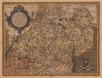
160153035Antwerp. 1601. Ornate map of Luxembourg eastern Belgium and part of North Eastern France with flamboyant strapwork decoration to title across upper centre. Decorated frame. The stippling around the scale identifies this as the later of two plates of the same subject. Published in Ortelius' landmark atlas the Theatrum Orbis Terrarum. Copper engraving. Fine condition Later colour. Size: 48.5 x 37.5 cm. Ref: Van den Broecke 64. unknown
1610M1953Antwerp c.1610. Very Good. Notes: Rare Cartographer Portantius Latin text on verso Size : 227x250 mm 8.875x9.875 Inches Coloring: Hand Colored Category: Maps Europe Estonia Latvia; unknown
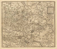
161233375Antwerpen: Juan Baptist Vrients 1612. In excellent condition. 368 by 430mm 14 by 17 inches. Hand-Colored Original Copperplate Engraving by Abraham Ortelius depicting Mansfeldiae Comitatus Descriptio auctore Tilemanno Stella. Sig. Published Antwerpen Juan Baptist Vrients 1612. Sheet: 368 by 430mm 14 by 17 inches. A fine and original hand-colored example of Ortelius's celebrated cartographic work documenting this region of Germany with the precision and decorative artistry characteristic of the 16100s. Abraham Ortelius 1527-1598 was a Flemish cartographer and geographer from Antwerp widely regarded as the creator of the first modern atlas. His landmark publication Theatrum Orbis Terrarum 1570 set the standard for atlas-making for the next century presenting uniform copper-engraved maps with scholarly commentary. By Ortelius's death the Theatrum had appeared in 25 editions in seven languages. In 1575 King Philip II of Spain appointed him Royal Geographer. His maps engraved with extraordinary precision are among the most sought-after in antique cartography held in collections including the Plantin-Moretus Museum in Antwerp the Library of Congress and the British Library.This original copperplate engraving with original hand coloring depicts the region of Mansfeldiae Comitatus Descriptio auctore Tilemanno Stella. Sig. published in Antwerpen Juan Baptist Vrients 1612. The map features a decorative Baroque cartouche containing the title inscription. A distance scale is incorporated within the cartouche or alongside it. The map records the political and geographic boundaries of the region as understood in 1612 offering a fascinating window into the history of German territorial organization. Sheet measures 368 by 430mm 14 by 17 inches. In good condition overall with minor signs of age appropriate for a 17th-century engraving. Ready to frame. Broe. 94 Koeman 32 Juan Baptist Vrients unknown
161235663Antwerpen: Christopher Platin 1612. In good condition. Old oxidations on the back. 35.6 x 475 cm 14 x 1875 inches. Original antique copper engraving old colored. Spanish text edition. Fine and decorative early map of Moravia. The map provides good information on early place names in the 16th century in Moravia as well rivers and mountains are engraved. Villages and towns are still shown as miniature views. In the upper left corner we find the renaissance cartouche and in the lower right corner we see a mileage scale with a circle and the coats of arms of Moravia. Christopher Platin unknown
160269318Antwerp. c.1602. A striking and very handsome map of the province of Namur in modern day Belgium. This map was first used by Ortelius in 1579 and it is based on the earlier map by I. Surhon. The map features a pair of stylish title cartouches and a directional compass. Namur is a province in Wallonia in the French speaking part of Belgium. The city stands astride the twin rivers of the Sambre and the Meuse. Published in Ortelius' landmark atlas the Theatrum Orbis Terrarum. Copperplate engraving with original colour. Size: 400x 525 mm Good condition. unknown
1601208175Antwerp: Ortelius Abraham 1601. unbound. very good. Map. Engraving with hand coloring. Image measures 15.5" x 20.25".<br/> <br/> Lovely map of the Namur region of Belgium. Includes a compass rose and a cartouche incorporating the Belgian coat of arms. From the 1601 Latin edition of Ortelius' "Theatrum Orbis Terrarum" the first modern Atlas. Margins have been cropped some chipping and tears along margins. Stain to top center margin and also to lower left and right of image.<br/> <br/> Ortelius, Abraham unknown
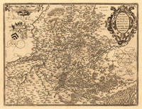
161220665Antwerpen: Juan Baptist Vrints 1612. Other. In very good to excellent condition. 369 by 488mm 14 by 19 inches. Original copper engraving published 1612 in a Italian text edition Vriens edition of the " Theatrum Orbis Terrarum. This antique map shows Hannonia in Belgium. The map is equipped with many small place names rivers woods etc. In the upper right corner we see an allegoric title cartouche and in the upper left corner a mileage scale and at the bottom two coat of arms. Ortelius was born on 14 April 1527 in the city of Antwerp which was then in the Habsburg Netherlands modern-day Belgium. The Orthellius family were originally from Augsburg a Free imperial city of the Holy Roman Empire. In 1535 the family had fallen under suspicion of Protestantism. Following the death of Ortelius's father his uncle Jacobus van Meteren returned from religious exile in England to take care of Ortelius. Abraham remained close to his cousin Emanuel van Meteren who would later moved to London. In 1575 he was appointed geographer to the king of Spain Philip II on the recommendation of Arias Montanus who vouched for his orthodoxy. He travelled extensively in Europe and is specifically known to have traveled throughout the Seventeen Provinces; in southern western northern and eastern Germany e.g. 1560 15751576; France 15591560; England and Ireland 1576; and Italy 1578 and perhaps twice or thrice between 1550 and 1558. Beginning as a map-engraver in 1547 he entered the Antwerp Guild of Saint Luke as an illuminator of maps. He supplemented his income trading in books prints and maps and his journeys included yearly visits to the Frankfurt book and print fair where he met Gerardus Mercator in 1554. In 1560 however when travelling with Mercator to Trier Lorraine and Poitiers he seems to have been attracted largely by Mercator's influence towards the career of a scientific geographer. Wikipedia Juan Baptist Vrints unknown
1630324748Antwerp: Abraham Ortelius 1630. unbound. Map. Engraving with hand color. Image measures 14" x 18 3/4".<br/> <br/> This beautiful map by Abraham Ortelius depicts the Balkan Peninsula or the Balkans extending from The Sea of Marmara Istanbul and the Bosporus Strait westward to Macedonia including Bulgaria. Portions of the Black Sea and the Thrakikon Pelagos are also shown. Topographical and geographical features such as mountains forests and cities are beautifully rendered in profile.<br> <br> Ortelius based this map on the 1560 South-East Europe map by Gastaldi and on on information from numerous ancient sources specifically Herodotus Plinius Strabo Appianus Virgilius Plutarchus and Sidonius. A beautifully engraved title cartouche adorns the top left of the map. Two additional cartouches containing text are also included in the top and bottom right.<br> <br> This map was published in the 1630 edition of Ortelius's famous "Theatrum Orbis Terrarum" which is historically considered the first modern atlas. Based on the Latin text on verso only 300 copies of this particular atlas were ever printed van der Broecke 214. The map is in good condition with minor wear and toning along the original centerfold. Printers crease to right margin not affecting the image. Latin text on verso.<br> <br> Abraham Ortelius 1527 - 1598 a Flemish cartographer and geographer is widely regarded as one of the important and influential cartographers in history. He is known for his "Theatrum Orbis Terrarum" which was the first modern atlas. Van den Broecke #214<br/> <br/> Abraham Ortelius unknown
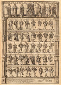
162425470Antwerpen 1624. Other. In excellent condition. 755 by 520mm 29 by 20 inches. Original copper engraving published 1624 in a Latin text edition of the famous historical atlas" Parergon by Abraham Ortelius. Printed from two plates. Latin text edition. Uncolored example in two sheets as published. Highly decorative engraving published from two double pages showing the dignitaries of the Holy Roman Empire. This engraving was published from 1593 for the first time in the atlas by Gerard de Jode. The plate was later acquired by Vrients and was then from 1603 onwards included in Ortelius' s "Theatrum" and the "Parergon". Our example was published 1624 in a Latin text edition of the Parergon."They represent the dignitaries entitled to choose German Emperors as instituted to end the turmoil and quarreling that occurred after the death of Charles the Great by Otto IV and the Pope. This plate shows left of the Emperor the highest ranking officials three ecclesiastical and four lay dignitaries. The second rank consists of four dukes and four marquesses the third of 8 earls." Broe. 201 Ortelius was born on 14 April 1527 in the city of Antwerp which was then in the Habsburg Netherlands modern-day Belgium. The Orthellius family were originally from Augsburg a Free imperial city of the Holy Roman Empire. In 1535 the family had fallen under suspicion of Protestantism. Following the death of Ortelius's father his uncle Jacobus van Meteren returned from religious exile in England to take care of Ortelius. Abraham remained close to his cousin Emanuel van Meteren who would later moved to London. In 1575 he was appointed geographer to the king of Spain Philip II on the recommendation of Arias Montanus who vouched for his orthodoxy. He travelled extensively in Europe and is specifically known to have traveled throughout the Seventeen Provinces; in southern western northern and eastern Germany e.g. 1560 15751576; France 15591560; England and Ireland 1576; and Italy 1578 and perhaps twice or thrice between 1550 and 1558. Beginning as a map-engraver in 1547 he entered the Antwerp Guild of Saint Luke as an illuminator of maps. He supplemented his income trading in books prints and maps and his journeys included yearly visits to the Frankfurt book and print fair where he met Gerardus Mercator in 1554. In 1560 however when travelling with Mercator to Trier Lorraine and Poitiers he seems to have been attracted largely by Mercator's influence towards the career of a scientific geographer. Wikipedia Broe. 201/202. State 2/2 xxij / xxj Latin text edition. unknown
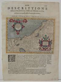
1610M1853Antwerp 1610. Excellent. Size : 137x178 mm 5.375x7 Inches Coloring: Hand Colored Category: ; Maps Asia Middle East Holy Land & Palestine unknown
16247957Antwerp: Plantin-Moretus 1624. Copper engraving 36 x 46 cms modern hand colour Latin text on verso. The Dalmatian coast in antiquity. Our example was published by Balthasar Moretus at the Plantin Press in the final edition of the Parergon. Ortelius's Theatrum Orbis Terrarum is generally considered the first modern atlas of the world originally published in 1570. Ortelius gathered and selected the best available cartographic knowledge and presented it in a single volume duly credited and finely engraved in a consistent style with explanatory text. The Theatrum was very decorative and hugely popular amongst the wealthy and educated running into over forty editions in Latin and the major European languages. For Ortelius himself however his accompanying atlas of ancient geography the Parergon was a "personal work" Koeman. He seems to have regarded himself first and foremost as an antiquary and rather than copying other people's maps he drew the originals himself; they were subsequently engraved for him by the master engraver Jan Wierix. The results have to be evaluated as the most outstanding engravings depicting the wide-spread interest in classical geography in the 16th century Koeman. Koeman Atlantes Neerlandici Ort 46. Van den Broecke 203.1 Map Plantin-Moretus unknown
1603213571Antwerp: Ortelius Abraham 1603. unbound. very good. Map. Engraving with original hand coloring. Image measures 13" x 18.25".<br/> <br/> Fine antique map of Perugia and Lake Trasimeno in central Italy in the Umbria region. Today the region is known it's foraged truffles and red wine. From 1603 edition "Theatrum Orbis Terrarum". Minor chipping to edges. Light stain near top centerfold. Full original margins. Abraham Ortelius 1527--1598 a Flemish cartographer and geographer is widely regarded as one of the important and influential cartographers in history. He is known for his "Theatrum Orbis Terrarum" which was the first modern atlas.<br/> <br/> Ortelius, Abraham unknown
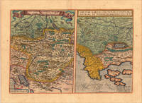
161213928Antwerp: Juan Baptist Vrients 1612. Other. In excellent condition. 340 by 500mm 13 by 19 inches. Original copper engraving published 1612 in the famous Vrients-edition of the Theatrum Orbis Terrarum. Finely hand-coloured in wash and outline. Two maps on one doublepage plate each one of them showing a title cartouche at the top centre. Villages and towns are shown as miniature views as well mountains and rivers are shown. The both maps are engraved after Wolfgang Lazius. This example is in very decorative colours and in excellent condition however the hand colour is probably done by a later hand. On the full sheet as published. The detailled map on the Duchy of Tirol is mainly showing South Tirol with the area Insbruck Trient the Lago de Garda towards Verona in the South. The other map is showing the area Carniola Istria and the so called "Windisch Mark". Ortelius was born on 14 April 1527 in the city of Antwerp which was then in the Habsburg Netherlands modern-day Belgium. The Orthellius family were originally from Augsburg a Free imperial city of the Holy Roman Empire. In 1535 the family had fallen under suspicion of Protestantism. Following the death of Ortelius's father his uncle Jacobus van Meteren returned from religious exile in England to take care of Ortelius. Abraham remained close to his cousin Emanuel van Meteren who would later moved to London. In 1575 he was appointed geographer to the king of Spain Philip II on the recommendation of Arias Montanus who vouched for his orthodoxy. He travelled extensively in Europe and is specifically known to have traveled throughout the Seventeen Provinces; in southern western northern and eastern Germany e.g. 1560 15751576; France 15591560; England and Ireland 1576; and Italy 1578 and perhaps twice or thrice between 1550 and 1558. Beginning as a map-engraver in 1547 he entered the Antwerp Guild of Saint Luke as an illuminator of maps. He supplemented his income trading in books prints and maps and his journeys included yearly visits to the Frankfurt book and print fair where he met Gerardus Mercator in 1554. In 1560 however when travelling with Mercator to Trier Lorraine and Poitiers he seems to have been attracted largely by Mercator's influence towards the career of a scientific geographer. Wikipedia Broe. 116 Juan Baptist Vrients unknown
1606m1300Antwerp: Published in "Theatrum Orbis Terrarum" c. 1606. Copperplate engraving. Old colour some darkening along c/f otherwise very good. 14" x 19-1/2. Based on Gastaldi's double sheet map. Shows Romania Bulgaria and western Turkey. Impressive oversized cartouche. Ortelius was one of the great Flemish cartographers of the 16th Century and produced what is considered to be the first modern world atlas. Van den Broecke 159 Published in "Theatrum Orbis Terrarum",
1603228104Antwerp: Abraham Ortelius 1603. unbound. very good. Map. Engraving with original hand coloring. Image measures 13.25" x 18.25".<br/> <br/> Beautifully colored map of Croatia. Shows place names topographical and geographical features a compass rose and a ship in the Adriatic. Latin text on verso. From "Theatrum Orbis Terrarum". Light scattered stains to margins and cartouche. Minor abrasion to upper right. A few small chips and tears to edges. Abraham Ortelius 1527--1598 a Flemish cartographer and geographer is widely regarded as one of the important and influential cartographers in history. He is known for his "Theatrum Orbis Terrarum" which was the first modern atlas. Van den Broecke 145<br/> <br/> Abraham Ortelius unknown
16028879Amsterdam c. 1602. Copper engraving 8 x 11 cm engraved by Philip Galle black and white English text on the verso. Two English printers dipped a toe in the vernacular atlas market at approximately the same time with pocket editions of the Ortelius atlas: These two little books were the earliest world atlases to be published in England and the earliest world atlases with English text R.A. Skelton "Bibliographical Note" in Abraham Ortelius The Theatre of the Whole World. Amsterdam 1968. Both are now extremely rare and they use different series of maps: Shawe used the maps by Arsenius Norton used the older series by Philip Galle. Shawe's epitome was certainly published before the death of Elizabeth I in March 1603; Norton's is dedicated to Mr. Richard Gargrave who was knighted by King James in 1603 so his atlas was published in early 1603 or before. It is generally dated to 1602 although the date 1601 has also been suggested. They were in any case published competitively within months of each other. Shawe published no further atlases Norton published the full-size folio Ortelius Theatrum in 1606. Koeman III Ort 62. Map unknown
16018877Antwerp Johann Baptist Vrients 1601. Copper engraving 7.5 x 11 cms black and white Latin text on verso. Sicily from the second series of maps engraved by Philip Galle for the Epitome the pocket atlas version of Ortelius Theatrum. Koeman Atlantes Neerlandici Ort 58 Map unknown
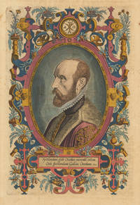
161230060Antwerp: Vrients 1612. Other. In exellent condition. 318 by 209mm 12 by 8 inches. Original antique copper engraving later hand colored. Latin text edition. This is the beautiful hand colored portrait of Abraham Ortelius as frontispiece to his "Theatrum Orbis". Engraved by Phillipe Galle. Ortelius was born on 14 April 1527 in the city of Antwerp which was then in the Habsburg Netherlands modern-day Belgium. The Orthellius family were originally from Augsburg a Free imperial city of the Holy Roman Empire. In 1535 the family had fallen under suspicion of Protestantism. Following the death of Ortelius's father his uncle Jacobus van Meteren returned from religious exile in England to take care of Ortelius. Abraham remained close to his cousin Emanuel van Meteren who would later moved to London. In 1575 he was appointed geographer to the king of Spain Philip II on the recommendation of Arias Montanus who vouched for his orthodoxy. He travelled extensively in Europe and is specifically known to have traveled throughout the Seventeen Provinces; in southern western northern and eastern Germany e.g. 1560 15751576; France 15591560; England and Ireland 1576; and Italy 1578 and perhaps twice or thrice between 1550 and 1558. Beginning as a map-engraver in 1547 he entered the Antwerp Guild of Saint Luke as an illuminator of maps. He supplemented his income trading in books prints and maps and his journeys included yearly visits to the Frankfurt book and print fair where he met Gerardus Mercator in 1554. In 1560 however when travelling with Mercator to Trier Lorraine and Poitiers he seems to have been attracted largely by Mercator's influence towards the career of a scientific geographer. Wikipedia Vrients unknown
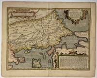
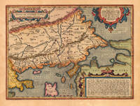
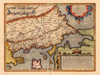
162421830Antwerp: Balthasar Moretus 1624. Other. A very good example in excellent condition. 360 by 480mm 14 by 19 inches. Original copper engraving published 1624 in the famous historical Atlas Parergon Latin text-edition by Abraham Ortelius. Finely hand colored in wash and outline. Fine and early historical map on Thracia. The area on this map covers mainly Thracia in Northern Greece and parts of Romania. The map is ornated with three cartouches in the upper left corner the title cartouche on the lower and upper right side we find text cartouches. Villages and towns are shown as miniature views. Ortelius was born on 14 April 1527 in the city of Antwerp which was then in the Habsburg Netherlands modern-day Belgium. The Orthellius family were originally from Augsburg a Free imperial city of the Holy Roman Empire. In 1535 the family had fallen under suspicion of Protestantism. Following the death of Ortelius's father his uncle Jacobus van Meteren returned from religious exile in England to take care of Ortelius. Abraham remained close to his cousin Emanuel van Meteren who would later moved to London. In 1575 he was appointed geographer to the king of Spain Philip II on the recommendation of Arias Montanus who vouched for his orthodoxy. He travelled extensively in Europe and is specifically known to have traveled throughout the Seventeen Provinces; in southern western northern and eastern Germany e.g. 1560 15751576; France 15591560; England and Ireland 1576; and Italy 1578 and perhaps twice or thrice between 1550 and 1558. Beginning as a map-engraver in 1547 he entered the Antwerp Guild of Saint Luke as an illuminator of maps. He supplemented his income trading in books prints and maps and his journeys included yearly visits to the Frankfurt book and print fair where he met Gerardus Mercator in 1554. In 1560 however when travelling with Mercator to Trier Lorraine and Poitiers he seems to have been attracted largely by Mercator's influence towards the career of a scientific geographer. Wikipedia Koe. Ort. 46; Balthasar Moretus unknown
162416765Antwerp: Balthasar Moretus 1624. Other. A very good example in excellent condition. 360 by 480mm 14 by 19 inches. Original antique copper engraving published 1624 in the famous historical Atlas Parergon Latin text-edition by Abraham Ortelius. Finely hand colored in wash and outline. Fine and early historical map on Thracia. The area on this map covers mainly Thracia in Northern Greece and parts of Romania. The map is ornated with three cartouches in the upper left corner the title cartouche on the lower and upper right side we find text cartouches. Villages and towns are shown as miniature views. Ortelius was born on 14 April 1527 in the city of Antwerp which was then in the Habsburg Netherlands modern-day Belgium. The Orthellius family were originally from Augsburg a Free imperial city of the Holy Roman Empire. In 1535 the family had fallen under suspicion of Protestantism. Following the death of Ortelius's father his uncle Jacobus van Meteren returned from religious exile in England to take care of Ortelius. Abraham remained close to his cousin Emanuel van Meteren who would later moved to London. In 1575 he was appointed geographer to the king of Spain Philip II on the recommendation of Arias Montanus who vouched for his orthodoxy. He travelled extensively in Europe and is specifically known to have traveled throughout the Seventeen Provinces; in southern western northern and eastern Germany e.g. 1560 15751576; France 15591560; England and Ireland 1576; and Italy 1578 and perhaps twice or thrice between 1550 and 1558. Beginning as a map-engraver in 1547 he entered the Antwerp Guild of Saint Luke as an illuminator of maps. He supplemented his income trading in books prints and maps and his journeys included yearly visits to the Frankfurt book and print fair where he met Gerardus Mercator in 1554. In 1560 however when travelling with Mercator to Trier Lorraine and Poitiers he seems to have been attracted largely by Mercator's influence towards the career of a scientific geographer. Wikipedia Koe. Ort. 46; Balthasar Moretus unknown
16247932Antwerp: Plantin-Moretus 1624. Copper engraving 36 x 48 cms modern hand colour Latin text on verso. Ancient Thrace extending from Macedonia to Byzantium following the cartography of Gastaldi supplemented by information from classical sources including Herodotus Strabo and Pliny. Our example was published by Balthasar Moretus at the Plantin Press in the final edition of the Parergon. Ortelius's Theatrum Orbis Terrarum is generally considered the first modern atlas of the world originally published in 1570. Ortelius gathered and selected the best available cartographic knowledge and presented it in a single volume duly credited and finely engraved in a consistent style with explanatory text. The Theatrum was very decorative and hugely popular amongst the wealthy and educated running into over forty editions in Latin and the major European languages. For Ortelius himself however his accompanying atlas of ancient geography the Parergon was a "personal work" Koeman. He seems to have regarded himself first and foremost as an antiquary and rather than copying other people's maps he drew the originals himself; they were subsequently engraved for him by the master engraver Jan Wierix. The results have to be evaluated as the most outstanding engravings depicting the wide-spread interest in classical geography in the 16th century Koeman. Koeman Atlantes Neerlandici Ort 46. Van den Broecke 214.2 Map Plantin-Moretus unknown
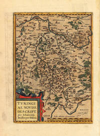
160315462Antwerpen 1603. Other. In excellent condition. 295 by 210mm 11 by 8 inches. Hand-Colored Original Copperplate Engraving by Abraham Ortelius depicting Thüringen. Published Antwerpen 1603. Sheet: 295 by 210mm 11 by 8 inches. A fine and original hand-colored example of Ortelius's celebrated cartographic work documenting this region of Germany with the precision and decorative artistry characteristic of the 16000s. Abraham Ortelius 1527-1598 was a Flemish cartographer and geographer from Antwerp widely regarded as the creator of the first modern atlas. His landmark publication Theatrum Orbis Terrarum 1570 set the standard for atlas-making for the next century presenting uniform copper-engraved maps with scholarly commentary. By Ortelius's death the Theatrum had appeared in 25 editions in seven languages. In 1575 King Philip II of Spain appointed him Royal Geographer. His maps engraved with extraordinary precision are among the most sought-after in antique cartography held in collections including the Plantin-Moretus Museum in Antwerp the Library of Congress and the British Library.This original copperplate engraving with original hand coloring depicts the region of Thüringen published in Antwerpen 1603. The map features a decorative Baroque cartouche containing the title inscription. A distance scale is incorporated within the cartouche or alongside it. The map records the political and geographic boundaries of the region as understood in 1603 offering a fascinating window into the history of German territorial organization. Sheet measures 295 by 210mm 11 by 8 inches. In good condition overall with minor signs of age appropriate for a 17th-century engraving. Ready to frame. Koeman Ort. 30; Broe. 96. unknown