Ortelius, AbrahamBiblio.com
285 résultats
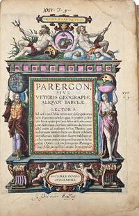
160312720Antwerp Jan Baptist Vrients 1603. Parergon sive veteris geographiae aliquot Tabulae . Engraved title 33 maps of the Ancient World 2 plates with costumes and 3 views ""Tempe"" ""Daphne"" and ""Escorial"". H. 43 x W. 30 cm. / H. 16.90 x W. 11.8 inch. A fine and complete copy of the Parergon by Abraham Ortelius 1527-1598 published in Antwerp in 1603. This celebrated companion to the Theatrum Orbis Terrarum represents one of the earliest and most influential works of historical cartography. The volume contains a full suite of maps illustrating the ancient world including the Roman Empire classical Greece and Biblical regions. All maps are original contemporary hand coloured exceptionally well-preserved and vibrant throughout. The engraved title page is richly decorated with allegorical figures and classical motifs. Latin text on verso. A highly decorative and scholarly work reflecting the humanist interest in antiquity and geography. Light age toning and occasional marginal wear are consistent with age. Overall a very attractive copy. Antwerp, Jan Baptist Vrients unknown
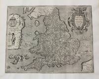
1603M10773Antwerp Belgium c.1603. Very Good margins extended. Notes: Important map of United Kingdom by Ortelius based on an earlier map by Christopher Saxton in 1579. Size : 384x483 mm 15.12x19.02 Inches Coloring: Hand Colored Category: Maps Europe United Kingdom England; Maps Europe Ireland; Maps Europe United Kingdom Wales; unknown
162451428Köln Ioannis Gymnici Antonius Boetzer 1624 a. 1621-1640. Folio. 40 x 26 cm. Bound in 8 thick uniform contemporary full pigskin bindings over wooden boards. Raised bands and richly blind-tooled boards. Title labels with gilt lettering. Clasps missing. Spines a bit rubbed. Wear to some spine-ends. Some upper compartments with nicks one volume having a tear in leather at upper compartment. One volume with a small loss of leather to upper compartement. With engraved title-page engraved portrait of Baronius engraved portrait of pope Urban VII. More than 10.000 pp. Printed in double-columns. In general internally fine. <br/><br/><em>Baronius's monumental work with its continuation by Bzovius up to the year 1565 hailed by Roman Catholic writers as the greatest history of the church ever written and Baronius hailed as the "father of ecclestical history" 1-12 dealt with Anno 1-1198 and volume13 -20 Anno 1198-1565."The Annales were first published between 1588 and 1607. This work functioned as an official response to the Lutheran Historia Ecclesiae Christi History of the Church of Christ. In that work the Magdeburg theologians surveyed the history of the Christian church in order to demonstrate how the Catholic Church represented the Antichrist and had deviated from the beliefs and practices of the early church. In turn the Annales fully supported the claims of the papacy to lead the unique true church."Before Baronius was appointed Librarian of the Vatican in 1597 he had access to material and sources in its archives that were previously unpublished or unused. He used these in the development of his work. Accordingly the documentation in Annales Ecclesiastici is considered by most as extremely useful and complete. Lord Acton called it "the greatest history of the Church ever written"."Graesse I 296. - Brunet I 662-631. </em> hardcover
162451428Köln, Ioannis Gymnici, Antonius Boetzer, 1624 a. 1621-1640. Folio. (40 x 26 cm.). Bound in 8 (thick) uniform contemporary full pigskin bindings over wooden boards. Raised bands and richly blind-tooled boards. Title labels with gilt lettering. Clasps missing. Spines a bit rubbed. Wear to some spine-ends. Some upper compartments with nicks, one volume having a tear in leather at upper compartment. One volume with a small loss of leather to upper compartement. With engraved title-page, engraved portrait of Baronius, engraved portrait of pope Urban VII. More than 10.000 pp. Printed in double-columns. In general internally fine.
1696211441Leyden and Utrecht: Pieter Vander Aa 1696. unbound. very good. Botanical. Copper plate engraving with hand coloring. Image measures 12.5" x 8.25".<br/> <br/> Abraham Munting 1626-1683 taught medicine and botany at the Academy of Groningem in the Netherlands. He had a particular interest in the uses of plants especially medicinally. This engraving is from "Naauwkeurige Beschryving Der Aardgewassen". Aging around edges. Please visit our gallery for more Munting prints.<br/> <br/> Pieter Vander Aa unknown
1696211441Leyden and Utrecht: Pieter Vander Aa 1696. unbound. very good. Botanical. Copper plate engraving with hand coloring. Image measures 12.5" x 8.25".<br/><br/> Abraham Munting 1626-1683 taught medicine and botany at the Academy of Groningem in the Netherlands. He had a particular interest in the uses of plants especially medicinally. This engraving is from "Naauwkeurige Beschryving Der Aardgewassen". Aging around edges. Please visit our gallery for more Munting prints.<br/><br/> Pieter Vander Aa unknown books
1606M8988Antwerp c.1606. Very Good. Notes: English text on verso. Size : 341x495 mm 13.43x19.49 Inches Coloring: Original Hand Coloring Reference: Van den Broecke 226. Category: Maps Mediterranean Sea; Maps Asia Near East Turkey; Maps Europe Greece Macedonia; Maps Europe Italy; unknown
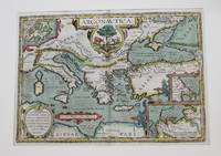
16051103040008Medius meri diannus 1605. Map. Very Good. 14 x 18 inches. Hand-colored. Extracted from the atlas Medius Meri Diannus. Ornately decorated and colored title cartouche in top right corner reads "Medius Meri Dianus 75 relequi ad cum inclinati funt ratione 50 and 58 perallelo rum." This beautifully crafted chart illustrates the region now known as the Ukraine and the Caucausus in vivid detail. Minor chipping around edges. Some discoloration due to age. Colors remain bright and vivid. A superior map in exquisite condition. Medius meri diannus unknown
1693000046Leipzig : David Fleischer 1693. Hardcover. Very Good/not applicable. No publisher no place no year. - Large 4to 33.5x20.5 cm. - 2 73 recte 75 38 p. - In Fraktur. Many errors of pagination. - Much later late 19th century half-clioth with marble-paper covered hard boards; quite worn. - Rare abbreviated printing of Schonberg's 1693 "magnum opus" which is of the size of 8 240 38 134 2 pages. -- For the present copy no publisher's name publication place or year given. Though the font is identical to that of the well described edition this is not a direct reprint - the present copy has a somewhat different spatial arrangement and contains many misprints for instance on the title-page "Vatterland" for "Vaterland" etc. not in the original. WorldCat describes it as : "Vermutlich in Leipzig bei David Fleischer gedruckt"; and the date is likely to be 1693 or close to it. -- Schonberg gives a comprehensive description of mining and of all kind of related practices such as prospecting underground surveying tunnel construction machinery flood control in mines washing of ore assaying smelting et. even administration and industrial relation. - The second part "Redens-arten" gives the terminology af mining in dictionary form. - Much rarer than the original: WorldCat gives only three locations: two in Denmark and one in Germany. <br/> <br/> David Fleischer (?) hardcover
160819024Antwerpen: Platin 1608. Other. In excellent condition. 330 by 500mm 13 by 19 inches. Original copper engraving published 1608 in an Italian text edition of the " Theatrum Orbis Terrarum. A good and strong impression of this map. This antique map shows North Africa with the Mediterranean Sea and the Atlantic coast. The map is equipped with many place names rivers mountains towns a small part of Italy Sicily the islands Corsica Sardinia Menorca Mallorca etc. The map is ornated with a large title cartouche in the upper margin as well we find for decoration a sea monsters and a ship in the sea. Villages and towns are shown as miniature views. Ortelius was born on 14 April 1527 in the city of Antwerp which was then in the Habsburg Netherlands modern-day Belgium. The Orthellius family were originally from Augsburg a Free imperial city of the Holy Roman Empire. In 1535 the family had fallen under suspicion of Protestantism. Following the death of Ortelius's father his uncle Jacobus van Meteren returned from religious exile in England to take care of Ortelius. Abraham remained close to his cousin Emanuel van Meteren who would later moved to London. In 1575 he was appointed geographer to the king of Spain Philip II on the recommendation of Arias Montanus who vouched for his orthodoxy. He travelled extensively in Europe and is specifically known to have traveled throughout the Seventeen Provinces; in southern western northern and eastern Germany e.g. 1560 15751576; France 15591560; England and Ireland 1576; and Italy 1578 and perhaps twice or thrice between 1550 and 1558. Beginning as a map-engraver in 1547 he entered the Antwerp Guild of Saint Luke as an illuminator of maps. He supplemented his income trading in books prints and maps and his journeys included yearly visits to the Frankfurt book and print fair where he met Gerardus Mercator in 1554. In 1560 however when travelling with Mercator to Trier Lorraine and Poitiers he seems to have been attracted largely by Mercator's influence towards the career of a scientific geographer. Wikipedia Platin unknown
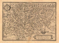
160235922Antwerpen 1602. Kräftig und gleichmäßig gedrucktes Exemplar. Tadellos. . 31 x 234 cm 12.25 x 925 inches. Hand-Colored Original Copperplate Engraving by Abraham Ortelius depicting Braunschweig Herzogtum. Published Antwerpen 1602. Sheet: 31 x 234 cm 12.25 x 925 inches. A fine and original hand-colored example of Ortelius's celebrated cartographic work documenting this region of Germany with the precision and decorative artistry characteristic of the 16000s. Abraham Ortelius 1527-1598 was a Flemish cartographer and geographer from Antwerp widely regarded as the creator of the first modern atlas. His landmark publication Theatrum Orbis Terrarum 1570 set the standard for atlas-making for the next century presenting uniform copper-engraved maps with scholarly commentary. By Ortelius's death the Theatrum had appeared in 25 editions in seven languages. In 1575 King Philip II of Spain appointed him Royal Geographer. His maps engraved with extraordinary precision are among the most sought-after in antique cartography held in collections including the Plantin-Moretus Museum in Antwerp the Library of Congress and the British Library.This plate presents a original copperplate engraving with original hand coloring depicting the city of Braunschweig Herzogtum published in Antwerpen 1602. The view is framed with a decorative Baroque cartouche containing the title inscription. Such topographic views from Ortelius's workshop are primary historical documents of German urban history in the 1600s now prized equally by historians map collectors and interior decorators. Sheet measures 31 x 234 cm 12.25 x 925 inches. In good condition overall with minor signs of age appropriate for a 17th-century engraving. Retains its original contemporary hand coloring. Ready to frame. Koem. Ort. 33 unknown
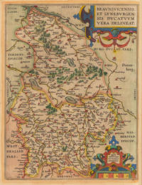
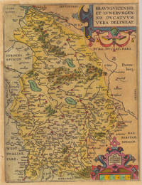
160235921Antwerpen: Vrients 1602. Still in acceptable condition. 31 x 235 cm 12.25 x 925 inches. Hand-Colored Original Copperplate Engraving by Abraham Ortelius depicting Braunsvicensis et Luneburgensis Ducatuum Vera Delineat. Published Antwerpen Vrients 1602. Sheet: 31 x 235 cm 12.25 x 925 inches. A fine and original hand-colored example of Ortelius's celebrated cartographic work documenting this region of Germany with the precision and decorative artistry characteristic of the 16000s. Abraham Ortelius 1527-1598 was a Flemish cartographer and geographer from Antwerp widely regarded as the creator of the first modern atlas. His landmark publication Theatrum Orbis Terrarum 1570 set the standard for atlas-making for the next century presenting uniform copper-engraved maps with scholarly commentary. By Ortelius's death the Theatrum had appeared in 25 editions in seven languages. In 1575 King Philip II of Spain appointed him Royal Geographer. His maps engraved with extraordinary precision are among the most sought-after in antique cartography held in collections including the Plantin-Moretus Museum in Antwerp the Library of Congress and the British Library.This original copperplate engraving with original hand coloring depicts the region of Braunsvicensis et Luneburgensis Ducatuum Vera Delineat. published in Antwerpen Vrients 1602. The map records the political and geographic boundaries of the region as understood in 1602 offering a fascinating window into the history of German territorial organization. Sheet measures 31 x 235 cm 12.25 x 925 inches. In good condition overall with minor signs of age appropriate for a 16th-century engraving. Ready to frame. Broe. 99 Vrients unknown
161232756Antwerpen: Vrients 1612. In excellent condition. 310 by 475mm 12¼ by 18¾ inches. Original antique copper engraving uncolored. Two maps on one doublepage sheet the Duchy of Brunswick-Lüneburg and the environs of Nuremberg. The Nuremberg area is shown on one map. In the north the map extends to Erlangen / Uttenreuth and in the south to Schwarzach. In the upper margin is the title Norimberg. Agri fidissima descrip. And below the map there is a large painted scrollwork cartouche and privilege. In the west the map extends from the Rednitz to Hersbruck in the east. Locations forests rivers lakes etc. were decoratively worked out. Koe. Ort. 42 Vrients unknown
160323753Antwerpen: J.B. Vrients 1603. Other. In excellent condition. 363 by 504mm 14 by 19 inches. Original antique copper engraving published 1603 at J.B. Vrients in an edition of Abraham Ortelius Theatrum. Finely hand colored in wash and outline. This antique historical map was published from 1595 to 1624 onwards in various edition of the Theatrum and the Parergon by Ortelius. Verso Latin text last line of text endsputant and with signature ix. The map is ornated with three cartouches in the upper middle the title cartouche in the upper right corner we find a cartouche with the privilegium. On the lower right side cartouche with text. Villages and towns are shown as miniature views moreover the map is ornated with ships. Ortelius was born on 14 April 1527 in the city of Antwerp which was then in the Habsburg Netherlands modern-day Belgium. The Orthellius family were originally from Augsburg a Free imperial city of the Holy Roman Empire. In 1535 the family had fallen under suspicion of Protestantism. Following the death of Ortelius's father his uncle Jacobus van Meteren returned from religious exile in England to take care of Ortelius. Abraham remained close to his cousin Emanuel van Meteren who would later moved to London. In 1575 he was appointed geographer to the king of Spain Philip II on the recommendation of Arias Montanus who vouched for his orthodoxy. He travelled extensively in Europe and is specifically known to have traveled throughout the Seventeen Provinces; in southern western northern and eastern Germany e.g. 1560 15751576; France 15591560; England and Ireland 1576; and Italy 1578 and perhaps twice or thrice between 1550 and 1558. Beginning as a map-engraver in 1547 he entered the Antwerp Guild of Saint Luke as an illuminator of maps. He supplemented his income trading in books prints and maps and his journeys included yearly visits to the Frankfurt book and print fair where he met Gerardus Mercator in 1554. In 1560 however when travelling with Mercator to Trier Lorraine and Poitiers he seems to have been attracted largely by Mercator's influence towards the career of a scientific geographer. Wikipedia Koe. Ort. 46; Broe. 192 Theatrum 16o3 Latin text edition signature ix; Shirley 1991 maps 186 pl. 71 259a 365. J.B. Vrients unknown
161218807Antwerp: Juan Baptist Vrients 1612. Other. In excellent condition. 375 by 458mm 14 by 18 inches. Original antique copper engraving published 1612 in the famous Italian text edition of the" Theatrum Orbis Terrarum published by Juan Baptist Vrients in Antwerp. An early and decorative map of the duchy of Burgundy in France by Abraham Ortelius published and printed from 1584 for the first time onwards. Ortelius was born on 14 April 1527 in the city of Antwerp which was then in the Habsburg Netherlands modern-day Belgium. The Orthellius family were originally from Augsburg a Free imperial city of the Holy Roman Empire. In 1535 the family had fallen under suspicion of Protestantism. Following the death of Ortelius's father his uncle Jacobus van Meteren returned from religious exile in England to take care of Ortelius. Abraham remained close to his cousin Emanuel van Meteren who would later moved to London. In 1575 he was appointed geographer to the king of Spain Philip II on the recommendation of Arias Montanus who vouched for his orthodoxy. He travelled extensively in Europe and is specifically known to have traveled throughout the Seventeen Provinces; in southern western northern and eastern Germany e.g. 1560 15751576; France 15591560; England and Ireland 1576; and Italy 1578 and perhaps twice or thrice between 1550 and 1558. Beginning as a map-engraver in 1547 he entered the Antwerp Guild of Saint Luke as an illuminator of maps. He supplemented his income trading in books prints and maps and his journeys included yearly visits to the Frankfurt book and print fair where he met Gerardus Mercator in 1554. In 1560 however when travelling with Mercator to Trier Lorraine and Poitiers he seems to have been attracted largely by Mercator's influence towards the career of a scientific geographer. Wikipedia Broe. 54 Juan Baptist Vrients unknown
161223589Antwerp: Juan Baptist Vrients 1612. Other. In excellent condition. 365 by 504mm 14 by 19 inches. Original antique copper engraving published 1612 in the famous Italian text edition of the" Theatrum Orbis Terrarum published by Juan Baptist Vrients in Antwerp. An early and decorative map of Burgundy in France by Abraham Ortelius which is based on the cartographical sources Ferdinand de Lannoy who made a map of Burgundy in 1563 for which he obtained a privilege but which was subsequently suppressed by the Spaniards for political reasons Broe. Ortelius was born on 14 April 1527 in the city of Antwerp which was then in the Habsburg Netherlands modern-day Belgium. The Orthellius family were originally from Augsburg a Free imperial city of the Holy Roman Empire. In 1535 the family had fallen under suspicion of Protestantism. Following the death of Ortelius's father his uncle Jacobus van Meteren returned from religious exile in England to take care of Ortelius. Abraham remained close to his cousin Emanuel van Meteren who would later moved to London. In 1575 he was appointed geographer to the king of Spain Philip II on the recommendation of Arias Montanus who vouched for his orthodoxy. He travelled extensively in Europe and is specifically known to have traveled throughout the Seventeen Provinces; in southern western northern and eastern Germany e.g. 1560 15751576; France 15591560; England and Ireland 1576; and Italy 1578 and perhaps twice or thrice between 1550 and 1558. Beginning as a map-engraver in 1547 he entered the Antwerp Guild of Saint Luke as an illuminator of maps. He supplemented his income trading in books prints and maps and his journeys included yearly visits to the Frankfurt book and print fair where he met Gerardus Mercator in 1554. In 1560 however when travelling with Mercator to Trier Lorraine and Poitiers he seems to have been attracted largely by Mercator's influence towards the career of a scientific geographer. Wikipedia Broe. 51 Juan Baptist Vrients unknown
163555473Leiden:: Ex officina Elzeviriana 1635. later full vellum with red gilt-lettered spine labels. Aside from the repair to the engraved title a beautiful clean copy. 16mo. Engraved title page trimmed close to the platemark and laid down; five full-page woodcut illustrations; three folding maps; portrait medallion. . Ex officina Elzeviriana, hardcover
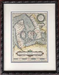
1610H15377Amsterdam 1610. Very Good. 13.5 x 9.75 inches double-matted and nicely framed; frame measures 20 x 16 inches. With original hand coloring very good with mild surface soil. Not examined outside of frame. This is the left-hand map of a sheet that had on the right a detailed map of Jutland. Part of Ortelius's Theatrum Orbis Terrarum considered the first great world atlas. unknown
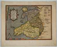
160915882Antwerp 1609. The first printed map of Wales with title translated as "Map of Wales by the author Humphrey Lhuyd the Welshman from Denbigh". Based on Mercator's 1564 wall map of the British Isles and Lhuyd's manuscript map of 1568. Ornate cartouche sailing ship and sea monsters. Latin text on verso. Van den Broecke and van den Broecke-Günzburger's Ortelius Map No. 21; 300 copies of this edition were printed. Image size: 19 1/2 x 14 1/2". Paper size: 23 x 18 3/4". Two stray printer's marks at lower margin otherwise very good. unknown
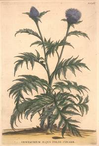
1696324021Leyden and Utrecht: Pieter Vander Aa 1696. unbound. Botanical. Copper plate engraving with hand coloring. Image measures 12 1/2" x 8 1/2".<br/> <br/> Fine print of a purple thistle-like flowering plant with jagged leaves. <BR> <BR> Abraham Munting 1626-1683 taught medicine and botany at the Academy of Groningem in the Netherlands. He had a particular interest in the uses of plants especially medicinally. This engraving is from "Naauwkeurige Beschryving Der Aardgewassen". Aging around edges and minor foxing. Please visit our gallery for more Munting prints.<br/> <br/> Pieter Vander Aa unknown
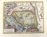
1612M10204Antwerp 1612. Very Good. Notes: Italian text on verso wide margins. <br>The first map of China to appear in a Western atlas with decorative cartouches.<br>The map is based on the work of Jorge de Barbuda a Portuguese Jesuit also known as Ludovicus Georgius whose manuscript map reached Ortelius by way of Arias Montanus. <br><br> Size : 365x470 mm 14.37x18.50 Inches Coloring: Original Hand Coloring Reference: Marcel P. R. van den Broecke #164 Category: Maps Asia Far East China; unknown
167622656Ohne Ort (Basel), Jakob Werenfels, 1676. 8°. Mit Holzschn.-Titelvignette. 40 S., Marmor. Kart.
16873053Oxford: Printed at Oxford 1687. First edition. 4to.12260pp. Cont. tooled paneled calf a bit worn surfaces pitted extremities of spine chipped front hinge split but still holding. Calf spine label listing the author as "Walker" chipped. Woodcut title page portrait. Minor worming at top blank margins text unaffected. The first four parts alluded to in the title were separate works published during Woodhead's lifetime. "Part V" is based on unpublished manuscripts found after his death in 1678. Wing W3440. Printed at Oxford unknown books
1612406876Antwerp 1612. Tape reinforcements along edge on verso without show-through and not affecting image a few foxmarks overall in very good condition with good color. Hand colored engraved map 12 5/8 x 9 7/8 inches image 16 1/2 x 10 5/8 inches sheet. Crossed arrows watermark. A fine map from Ortelius's atlas showing Lake Constance the Danube and Rhine. Bounded by the Lech Odenwald Alsace and Chur in Switzerland. unknown
1612406876Antwerp 1612. Tape reinforcements along edge on verso without show-through and not affecting image a few foxmarks overall in very good condition with good color. Hand colored engraved map 12 5/8 x 9 7/8 inches image 16 1/2 x 10 5/8 inches sheet. Crossed arrows watermark. A fine map from Ortelius's atlas showing Lake Constance the Danube and Rhine. Bounded by the Lech Odenwald Alsace and Chur in Switzerland. <br/><br/> unknown books