9 034 résultats
Foglio 249; II.S.O. - Tavoletta in scala 1:25.000 della "Grande Carta topografica del Regno d?Italia e regioni adiacenti" dell?Istituto Geografico Militare di Firenze. Circa cm. 41x42, pi— i margini. Montata su tela a riquadri all'epoca. VG-. ** Monreale si trova al margine superiore. Comprende anche: Pioppo, Monte Gibilmesi, Pizzo dell'Assolicchiata, Carpineto, Argomazit, Parco...
Foglio 258; I.N.O. - Tavoletta in scala 1:25.000 della "Grande Carta topografica del Regno d?Italia e regioni adiacenti" dell?Istituto Geografico Militare di Firenze. Circa cm. 41x42, pi— i margini. Montata su tela a riquadri all'epoca. Alcune lievi tracce di sottolineature. G++. ** Piana dei Greci (dal 1941 divenuta Piana degli Albanesi) Š vicina al margine superiore. Comprende anche: Monte Pagnocco, Fiume Grande (Belice destro), Portella Ginestra, Fiume di Petralonga...
Fotografie 1983 - 2013. Intr. di Nifosi P. - Lauretta F. Cammareri G. Ispica (Rg) Martorana 2014. In 8°; pp. 204, interamente fotografico a col. nt. Dedica autografata dell'A. all'occhiello.
Testi di G. Cammareri. Rosolini Santocono 2009. In 8°; pp. 372, con moltissime fotografie a col. nt. Brossura ill.
Carta geografica pubblicata nella Cosmographia Universalis (Cosmographey Oder beschreibung Aller Länder) di Sebastian Muenster, a partire dal 1564 circa. La Gumina: "Il disegno della Sicilia si associa con-cettualmente alle produzioni tolemaiche che privilegiano l'aspetto artistico alla pura divulgazione geografica. Il profilo dell'Isola è assimilable a un triangolo equilatero che pone la costa meridionale sul fianco basso del foglio in parallelo alle coste africane, con proporzioni del tutto falsate. La rimodulazione sulla carta Münster 1550 è manifesta sia nel comparto grafico (ripresi i riferimenti a Graecia magna Calabria e Africa Barbarie), sia nella semiologia dell'entroterra e dei litorali, riprodotti con le tipiche rientranze semicircolari delle carte nautiche; la dislocazione e il disegno delle isole minori, l'idrografia fluviale e l'orografia sono anch'esse nuove interpretazioni della Münster 1550. Scarsa la toponomastica, con la citazione Saragozza (Siracusa) tipica delle carte nautiche e varianti riconoscibili in Lustegua per Ustica e Maretamo per Ma- rettimo, discostandosi in parte dal modello Münster anche nella resa di Capo passaro per Pachynus, Trapani per Drepanum Stromboli per Stringoli. Malgrado il ridotto numero di toponimi è segnalato, sullo stretto di Messina, Raso culmo (già nella Gastaldi-Maurolico pubblicata nel 1545) a sostituire Pharus della Münster. Animali marini e velieri arricchiscono l'apparato decorativo". Tavola tratta dalla Cosmographiae Universalis, edizione in tedesco, Basilea, seconda metà del XVI secolo. La Cosmographiae Universalis di Sebastian Münster (1488-1552), stampata per la prima volta Basilea nel 1544 dall’editore Heinrich Petri, venne più volte aggiornata e aumentata di nuove carte geografiche e rappresentazioni urbane nelle sue numerose edizioni che arrivano all’inizio del secolo successivo. Münster aveva lavorato a raccogliere informazioni al fine di ottenere un'opera che non deludesse le aspettative e, dopo un'ulteriore pubblicazione in tedesco abbellita da 910 stampe su legno, giunse nel 1550 all'edizione definitiva in latino, illustrata da 970 silografie. Vi furono poi numerose edizioni in diverse lingue, fra cui latino, francese, italiano, inglese e ceco. Dopo la sua morte di Münster (1552), Heinrich Petri prima, e il figlio Sebastian poi, continuarono la pubblicazione dell’opera. La Cosmographia universalis fu uno dei libri più popolari e di successo del XVI secolo, e vide ben 24 edizioni in 100 anni: l'ultima edizione tedesca venne pubblicata nel 1628, molto tempo dopo la morte dell'autore. La Cosmographia conteneva non solo le ultime mappe e vedute di tutte le città più famose, ma anche una serie di notizie enciclopediche di dettagli relative al mondo conosciuto, e sconosciuto. Il particolare successo anche commerciale di quest'opera fu dovuto in parte alle belle incisioni (tra i cui autori si possono citate Hans Holbein il Giovane, Urs Graf, Hans Rudolph Manuel Deutsch, David Kandel). Silografia, bella coloritura a mano, in buone condizioni. Plate taken from the Cosmographiae Universalis, German edition, Basel, second half of the 16th Century. The Cosmographiae Universalis of Sebastian Münster (1488-1552), printed for the first time in Basel in 1544 by the publisher Heinrich Petri, was updated several times and increased with new maps and urban representations in its many editions until the beginning of the next century. Münster had worked to collect information in order to obtain a work that did not disappoint expectations and, after a further publication in German embellished with 910 woodblock prints, arrived in 1550 to the final edition in Latin, illustrated by 970 woodcuts. There were then numerous editions in different languages, including Latin, French, Italian, English and Czech. After his death in Münster (1552), Heinrich Petri first, and then his son Sebastian, continued the publication of the work. The Cosmographia universalis was one of the most popular and successful books of the 16th century, and saw as many as 24 editions in 100 years: the last German edition was published in 1628, long after the author's death. The Cosmographia contained not only the latest maps and views of all the most famous cities, but also a series of encyclopedic details related to the known, and unknown, world. The particular commercial success of this work was due in part to the beautiful engravings (among whose authors can be mentioned Hans Holbein the Younger, Urs Graf, Hans Rudolph Manuel Deutsch, David Kandel). Woodcut, beautiful hand-coloring, in good condition. L. Dufour - A. La Gumina, "Imago Siciliae", p. 71; Sicilia 1477-1861 - La collezione Spagnolo- Patermo, n. 22.
Carta nautica tratta dal raro atlante nautico "Recueil de plusieurs Plans des Ports et Rades et de quelques Cartes particulières de la Mer Méditerranée, avec les figures des Terres remarquables pour les reconnoissances des Atterrages", edito tra il 1732 ed ll 1746.Jacques Ayrouard, idrografo francese, risulta attivo tra il 1730 ed il 1750; il raro atlante dei porti del Mediterraneo rimane la sua unica opera. Il lavoro di Ayrouard costituisce uno strumento fondamentale per la navigazione costiera, registrando suoni, ancoraggi e note di pilotaggio su rocce e scogliere e include una serie di profili costieri come ulteriore aiuto alla navigazione. Questo atlante nautico sarebbe stato successivamente disegnato da numerosi idrografi, in particolare William Heather che cita Ayrouard nel suo “New Mediterranean Pilot” del 1802. Ayrouard dedica il lavoro a Jean Frédérick Phélypeaux, conte di Maurepas, segretario della casa reale e ministro della marina in la corte di Luigi XV, che fu prominente nel tentativo di introdurre un approccio più scientifico agli affari navali fino a quando fu esiliato nel 1749 per aver scritto dispregiativi epigrammi sull'amante del re, Madame de Pompadour. Il Conseil de la Marine, per il quale questa opera sembra essere stata prodotta, era stato fondato nel 1720 come depositario centrale di mappe, piani, diari e memorie relative alla navigazione. Dell'idrografo Ayrouard, poco si sa oltre i brevi dettagli che dà sul titolo in cui si definisce "Royal pilot of the King's Galleys" e spiega che questi grafici sono stati preparati da lui in viaggi che ha intrapreso sulla costa, conducendo aggiungere ulteriori note di pilotaggio per l'ingresso sicuro in alcuni porti e strade ("avec les Remarques necessaires qu'il faut observer pour l'entrée à Certains Ports et autres Endroits"). Allo stesso modo, l'incisore di questi grafici superbamente dettagliati, Louis Corne, è noto a Tooley esclusivamente da questo lavoro. Incisione in rame, in ottimo stato di conservazione. Sea chart from the rare Atlas Recueil de Plusiers Plans des Ports et rades de la Mer Mediterranée, printed in between 1732 and 1746. Jacques Ayrouard, a French hydrographer, worked between 1730 and 1750; the rare Mediterranean harbours atlas is his sole work. Ayrouard's work forms a working "waggoner" for the coast, recording soundings, anchorages, and pilotage notes on rocks and reefs, and includes a series of coastal profiles as a further aid to navigation. This pilot would subsequently be drawn on by numerous hydrographers, most notably William Heather who cites Ayrouard in his New Mediterranean Pilot of 1802. Ayrouard dedicates the work to Jean Frédérick Phélypeaux, comte de Maurepas, secretary to the royal household and minister of the navy in the court of Louis XV, who was prominent in attempts to introduce a more scientific approach to naval affairs until he was exiled in 1749 for writing derogatory epigrams about the king's mistress, Madame de Pompadour. The Conseil de la Marine, for whom this work appears to have been produced, had been founded in 1720 as a central depository for maps, plans, journals, and memoirs relating to navigation. Of the hydrographer Ayrouard, little is known beyond the brief details he gives on the title where he describes himself as "Royal pilot of the King's Galleys," and explains that these charts were prepared by him on voyages that he undertook on the coast, leading him to add further pilotage notes for the safe entry into certain of the harbours and roads ("avec les Remarques necessaires qu'il faut observer pour l'entrée á Certains Ports et autres Endroits"). Similarly, the engraver of these superbly-detailed charts, Louis Corne, was known to Tooley solely from this work. It is possible that this was a local production, perhaps produced in Marseille, hydrographer and engraver brought together under the aegis of the Conseil de la Marine to produce this pilot for the benefit of visitinCopperplate, in excellent condition. NMM 206; Shirley, British Library, M.AYR-1a.; LC 7862. The Map Collector, Issue 24, p.49.
104679Palermo, 1980 - 1982.
189 p., 25 Pl. N.B. Plastifiage du bord de la couvertue arraché. Inv. 18002.
374 p., 288 fig. n/b. Inv. 17265
"Though primarily dedicated to potters, this book will be of great interest to students and teachers in all craft areas and especially to other admirers of Indians." - from dust jacket. Usual library markings. Binding sound. A worthy working copy. Book
Opera riccamente illustrata in nero, con prefazione di Elio Tandurella (43d).
Milano, 1941, stralcio con copertina posticcia muta, pp. 874/880 con ill. a colori. - !! ATTENZIONE !!: Con il termine estratto (o stralcio) intendiamo riferirci ad un fascicolo contenente un articolo, completo in se, sia che esso sia stato stampato a parte utilizzando la stessa composizione sia che provenga direttamente da una rivista. Le pagine sono indicate come "da/a", ad esempio: 229/231 significa che il testo è composto da tre pagine. Quando la rivista di provenienza non viene indicata é perché ci è sconosciuta. - !! ATTENTION !!: : NOT A BOOK : “extract” or “excerpt” means simply a few pages, original nonetheless, printed in a magazine. Pages are indicated as in "from” “to", for example: 229/231 means the text comprises three pages (229, 230 and 231). If the magazine that contained the pages is not mentioned, it is because it is unknown to us.
[Tram-Messina] (17x25), pp. 236, ill. b.n., cartonato. Il titolo può trarre in inganno, perché il tram a Messina, introdotto nel 1890 con le linee a vapore, ha vissuto per circa 60 anni, fino alla chiusura dell'ultima linea elettrica nel 1951. Ma oggi il tram a Messina sta rinascendo a nuova vita ed è diventato realtà: ecco quindi i 123 anni.Gli autori, il primo ingegnere e il secondo architetto, hanno rievocato la storia e le vicissitudini della rotaia urbana di Messina con scrupolose testimoneanze, molte riproduzioni di documenti e numerose immagini d'epoca, in gran parte inedite.Descrivono inoltre complementi a carattere tecnico, che valgono a mettere in luce elementi originali dei tram messinesi di ieri, accanto a rievocazioni, di episodi e di persone, e a ricordi del modo di vivere, in un mondo che sembra lontano anni luce, mentre a ben guardare è solo dell'altro ieri.
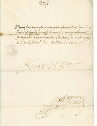
156298780Milan 1562. 1562. - Folio 12 inches high by 8-1/2 inches wide. 1-page on bifolium with a red paper seal. On the 4th leaf with the seal the letter is addressed "APRmo 5 Mons : Vescovo di Cremona". The letter realized in a secretarial hand is dated April 5 1562 from Milan and is boldly signed by Francesco Fernando dÁvalos d'Aquino d'Aragona.<p>Philip II King of Spain and Duke of Milan chose Francesco Fernando dÁvalos to be his envoy at the Council of Trent. He arrived in Trent on March 14 1562 and attended the sessions of the council. He pressed the Spaniards to not offer up anything against the interests of the Holy See. Upon his return to Milan he charged his secretary Ercole Pagnano with the task of generating a report. As the Governor's agent Pagnano had defended the privileges of the Sicilian monarchy and worked with the Spaniards to quell the controversy regarding the jurisdiction of bishops. In this letter to the Bishop of Cremona the Governor is offering Pagnano's report to him. Loosely translated he states that Pagnano is well informed about these things and that "V.S." Your Excellency should be given his account.<p>The letter was once folded into 4 panels and there very minor breaks along 3 of the folds. There is some minor browning especially to one of the folds. <p>An advisor to King Philip II of Spain Francesco Fernando dÁvalos c.1530-1571 took command of the Spanish army in Lombardy and Piedmont succeeding the 3rd Duke of Alba who had become the Governor of Milan. From 1560 to 1563 Francesco Fernando served as the Governor of the Duchy of Milan. He was the viceroy of Sicily from 1568 to 1571.<p>The Bishop of Cremona was born Niccolo Sfondrati in 1535 in the Duchy of Milan. Philip II of Spain appointed him to be a senator in Milan in 1552 and at the urging of the Spanish government the Pope appointed him Bishop of Cremona in 1560. He participated in some of the sessions of the Council of Trent from 1561 to 1563. In 1590 he was one of seven cardinals that were acceptable to be pope by Philip II of Spain. He was elected Pope and took the name Gregory XIV. He died less than a year later in October 1591. Milan, 1562. unknown
1 Vol. 6.MOLA:Convento dei Cappuccini sulle montagne pag. 5.SIRACUSA:L'Orecchio di Dionigi 7.MESSINA:Passo di S. Alessio-8.MESSINA:Rovine chiamate Abazie 9.ETNA:Veduta ai Cappuccini -10.Rovina del tempio di Giove 11.CHIARAMONTE:Val di Noto-12.SIRACUSA:Antiche strade con tombe PROG 11573 CATT_ATT 20
In-4 (cm. 28.90), brossura illustrata, pp. 101, (3), con illustrazioni in bianco e nero e a colori nel testo. Eitichette al piatto posteriore. Peraltro, volume in ottimo stato (nice copy).
4-23070Palermo 1933 folio cop. ill. col. di Monti pp. 24 con num. ill. mancano le pag. int. 9/16. All'inizio vi è un "Elogio della vita scomoda" con un dis. Autoritratto ed altri sei disegni firmati e non sono qui presenti : di Renato Guttuso. unknown
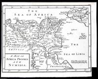
1748372042Printed for T. Osborne in Gray's Inn; A. Miller in the Strand; and J. Osborn in Paternoster Row London 1748. Unframed Print. Very Good Condition. This 1748 engraved map provides a detailed representation of North Africa focusing on Africa Propria the Roman province of Africa Numidia a Berber kingdom and Sicily & Carthage two historically significant locations in the Mediterranean. It was engraved by Isaac Basire a well-known cartographer of the time. The engraving was printed in London by T. Osborne A. Miller and J. Osborn.1 folding plate. Size: 20 x 28 cms. Category: Universal History; PRINTS : Antiquarian Interest; Printed before 1800; Special Features. This item may require more postage than the rates shown for delivery outside the UK. If extra postage is required we will contact you before processing your order and you will be given the details and option to decline the extra cost. Printed for T. Osborne, in Gray's Inn; A. Miller, in the Strand; and J. Osborn, in Paternoster Row unknown
In due volumi vengono analizzati i vari aspetti della vita italiana: politica, arte, giornalismo, economia, ecc. - Con 430 (vol. I) e 410 (vol. II) ill. di vario tipo quali: fotografie, diagrammi e cartine. Opera del noto storico siciliano (23h).
ML2771Aurillac, Imprimerie Gentet, 1894, in12br, 230pp
(Collana : Le scie) Opera fondamentale sull'argomento - Ill.ft (43g).
(Codice SW/2225) In 8° (27 cm) 80 pp. Brossura editoriale, riparazioni alla copertina. ~~~ SPEDIZIONE IN ITALIA SEMPRE TRACCIATA
8° bross. edit. pp. 24
(Collana : Documenti CEDI - n. 6) Edizione speciale per il convegno su : sistemi avanfossa - avanpaese lungo la catena Appennino Maghrebide; Naxos Pergusa 22-24 Aprile 1987, costituita da n. 2 voll. in brossura corredati da ill. e tavv. f.t., alcune delle quali più volte ripiegate (27I).
Manifesto, cm. 100x70. Movimento Giovanile PSIUP Livorno. "1 Gennaio 1969 Inizia un altro anno di lotta contro i padroni e lo stato Borghese"