Simone de Lattre de TassignyLivre Rare Book
225 résultats
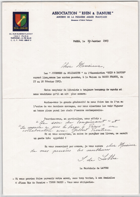
1983boz_001856Lettre signée à Thierry MAULNIER | Association Rhin & Danube 1983. Lettre tapuscrite signée de Simone de Lattre de Tassigny, présidente de l’Association Rhin & Danube, adressée à l’écrivain et académicien Thierry Maulnier. Rédigée sur papier à en-tête de l’association et datée du 19 janvier 1983. Bon état, voir photos. 1 page. Dimensions : A4. Nombre de pages : 1.
Very Good German Original color map on cloth. Oblong atlas folio. (46 x 52 cm). Toponyms in German. [MAP of BALKANS] J.10. Glina and around. North Bosnia and Herzegovina sheet. A sheet of the collection of 'The general map of Central Europe'. appeared in the years between 1873-1876 with the work of Joseph Ritter von Scheda, (1815-1888) who was a general, geographer and cartographer.
Very Good German Original color map on cloth. Oblong atlas folio. (46 x 52 cm). Toponyms in German. [MAP of OTTOMAN BALKANS] L.14. Berat. Shows South Albanian shores, Corfu, Berat et alli. Lithography. (Argyrokastro). A sheet of the collection of 'The general map of Central Europe'. appeared in the years between 1873-1876 with the work of Joseph Ritter von Scheda, (1815-1888) who was a general, geographer and cartographer.
20161-3330742194Novas Edições Acadêmicas 2016. Paperback. New. 124 pages. Portuguese language. 8.66x5.91x0.28 inches. Novas Edições Acadêmicas paperback
46 pages. Abundantly illustrated with colour and black and white archival photos. Features: Bill Maximick - Profile of a Western Artist - one of British Columbia's most respected marine artists; When Whales Were Fair Game - Between 1910 and 1943 Rose Harbour and other whaling stations whaled the Pacific; Amur, Danube & Tees - Three Pioneer West Coast Steamers that carried gold-seekers to the Klondike; Blue-Coated Mounties - The Alberta Provincial Police; Klondike Joe Boyle. Clean, bright and unmarked with very light wear. An excellent copy. Book
1990REIS0485Graz, Adeva (1990). Quer-4°. 20 S. (Titelei u. Einführung), 128 S. (Faks. v. Bd.1) u. 136 S. (Faks. v. Bd.2). Mit zus. 100 Ansichten auf Taf. Roter OLederbd. m. goldgepr. Rü.- u. Deckeltitel. Tadelloses Exemplar. Nummer LXXIX von 100 handschr. num. Exemplaren der VA in Leder (Gesamtauflage 1080 Ex.). - Hübscher Faksimileband der 1838-39 im Bibliograph. Inst. v. Joseph Meyer erschienenen 'Donau-Reise' des deutschen Bibliothekars, Dichters und Schriftstellers Ludwig Bechstein (1801-1860). B. unternahm die Reise von Donaueschingen entlang und auf der Donau bis ins schwarze Meer und dann weiter nach Konstantinopel und Athen. Den Stahlstich-Ansichten liegen zeichnerische Vorlagen u.a. von Jakob Alt und Ludwig Erminy zugrunde.
1507In 8 percaline éditeur rouge,titre doré au dos et sur le premier plat avec encadrement noir et doré.Faux-titre,frontispice illustré,titre,498 pages tranches dorées,illustrations hors-texte gravées sur bois de Karl Girardet.Mame et Cie 1863.rousseurs éparses habituelles.
1877K-1473Wien, Kaiserlich-K?nigliches Milit?r-Geographisches Institut, 1877. Formatangabe ca 50 x 37 cm, gefaltet zu 15 Segmenten, auf Leinen aufgezogen, Ausgabe: einf?rbig ; Zustand: gut +
Very Good Turkish, Ottoman (1500-1928) Original color map. Folded. Oblong atlas folio. (50 x 60 cm). In Ottoman script. Scale: 1/200.000. [MAP of EAST ANATOLIA - ERZERON] [Erzurum:] Oltu, Artvin, Hasankale, Ispir. This is one the serie of the Bonn projection maps which are the first map series in modern techniques in Turkey and the Ottoman Empire. This is one the serie of the Bonn projection maps which are the first map series in modern techniques in Turkey and the Ottoman Empire. In order to produce these maps covering Turkish territory, Reconnaissance Branch was incorporated into The Mapping Commission. The maps were produced in the datum based on the latitude and longitude of Ayasofya Mosque in equal area Bonn Projection. The field works for the 123 sheets covering the country were conducted by 76 staff. The production was completed in 18 years starting from east west. Field works continued without stopping except in years 1914 and 1920. This map series called also reconnaissance maps contributed a lot to producing 1:25.000 scale maps. Not in Ataturk Library and TBMM Library.
Very Good German Original color map on cloth. A little foxing on cloth. Very good. Folded. Folio. (57 x 43 cm). Toponyms in German. [MAP of BALKANS] 40-44 Zajecar. [Macedonia, Donau -Danube- River, Hungary and Bulgaria border, East Serbia].
Very Good German Original color map on cloth. Folded. A good copy. Oblong folio. (45 x 51 cm). In German. [MAP of BULGARIA]. Rusçuk. [Ruse]. Donau River, Plevna, Nikoli. A sheet of the collection of 'The general map of Central Europe'. appeared in the years between 1873-1876 with the work of Joseph Ritter von Scheda, (1815-1888) who was a general, geographer and cartographer.
1984GRAP0206(Wien, ca 1984). gerahmt; Bildausschnitt: 39x50,5 cm; Außenmaß: 54,3x65,2 cm; Rahmen links unten geringfüg. abgesplittert, an Oberkante (Rückenrand) kl. Lochverletzung.
1939BA9-130Budapest, [Hungarian Frontier Readjustment League, etc.], 1939. original Broschur, 8?, 64/64/64/64 pages, a good copy
1939CC10-945Budapest, [Hungarian Frontier Readjustment League, etc.], 1939. original Broschur, 8?, 64/64/64/64 pages, a good copy
1884K-2181Wien, Milit?rgeographisches Institut, 1884. Karten aneinandermontiert: Formatangabe ca 100 x 37 cm, gefaltet zu 16 Segmenten, Ausgabe: einf?rbig; Zustand: Randl?suren, Titel und Ma?st?be auf R?ckseite aufkaschiert, Markierungen mit rotem Bunstift ausslie?lich auf G?nserndorf-Karte, sonst gut
6209813046.Gpaperback. Good. Access codes and supplements are not guaranteed with used items. May be an ex-library book. paperback
6209820727.Gpaperback. Good. Access codes and supplements are not guaranteed with used items. May be an ex-library book. paperback
6209825842.Gpaperback. Good. Access codes and supplements are not guaranteed with used items. May be an ex-library book. paperback
1876K-1449Wien, Kaiserlich-K?nigliches Milit?r-Geographisches Institut, 1876. Formatangabe ca 50 x 37 cm, gefaltet zu 12 Segmenten, Ausgabe: einf?rbig ; Zustand: Titel und Ma?stab auf R?ckseite aufkschiert, ein Fleck in linker unterer Ecke, ansonsten gut +
63-8178Paris: Hotel Du Danube 1887. 11 x 35 cm. Folded Page. Hand-written Signed Receipt on Hotel Du Danube letterhead. Very Good. En Francais. Paris: Hotel Du Danube, 1887. unknown
191626968London England: Linnean Society's Journal - Botany 1916. C. 55 pages; with 11 very sharply defined black and white photo-plates on heavy paper stock illustrated in the collotype process taken by the author & printed by the London Stereoscopic Co.; several of the plates with human perspective-witnesses wearing the local cultural garb of the time. A folding black and white survey map of The Delta of the Danube according to the latest surveys of the Rumanian Fisheries Commission approx. 14" x 15 is at the back. This is the separately-printed offprint edition of this report extracted from the Linnean Society's Journal - Botany Vol. xliii July 1916. The botanical researcher and author Marietta Pallis 1882-1963 notes that her ".acquaintance with Plav dates from September 1912 when I went to Rumania to study the aquatic vegetation of the Danube valley and delta. I had for some years past been working at the vegetation of the Norfolk Broads and it was with the object of gaining for comparative purposes some knowledge of similar localities and their vegetation that I decided to visit the Danube in Rumania where it seemed to me probable that the most primitive aquatic vegetation in Europe would be found." Previous owner name on cover at top edge. Approx. 7" x 10 1/4" size original printed blue paper wrap covers. Some edge tips wear and darkening of the binding back cover with closed edge-tears 'v'-shaped edge-bump & short tears at back no losses; in very good condition. . Offprint Edition. Soft Cover. Very Good. Linnean Society's Journal - Botany paperback books
186387074Ad. Mame et Cie, imprimeurs-Libraires 1863 In-4. Reliure éditeur demi-chagrin rouge, dos à faux-nerfs encadrés de fers dorés, 497 pp. Coiffe de tête arrachée, mouillure continue en pied sur les 60 premières pages, sinon intérieur frais.
6261suivie d’une notice sur le Danube par J.MICHEL et l’explication des inscriptions par M Léon RENIER,in 12 pleine toile verte de l’éditeur,faux-titre, frontispice titre,295 pages tranches dorées,illustrations hors-texte complet des deux cartes en fin de volume,Adrien Le Clerc & Cie .Dillet éditeur,sans date.
1863DEZ-950Tours, Mame, 1863. In-8, demi chagrin, dos à nerfs orné de fleurons et de filets dorés, titre doré, toutes tranches dorées, 498 pp. Ouvrage illustré de nombreuses illustrations hors texte en noir par Girardet. Plats restaurés, dos légèrement insolés, quelques rousseurs.