469 résultats
188743533London: Sampson Low Marston Searle & Rivington 1887. 8vo. xiv 2 248 pp. plus 32 pp. publ. ads. Frontisp. numerous text illusts. 2 colour maps 1 large folding. Illust. gray-blue cloth illust. of scene w/ kayak & canoe on front cover gilt lettering minor bumping to couple corners foot of spine minor rubbing old shelf number at foot of spine still a VG- copy. First edition of this fascinating account by the famed Victorian big game hunter archaeologist mountaineer and explorer. Seton Karr 1859-1938 describes in the book how his party were some of the first passengers to cross Canada by the new Canadian Pacific Railway then a steamship journey north where he made an attempt to scale the 18000 ft. summit of Mount St. Elias but his climbing party was forced back at 7200 feet. Of interest are also his observations of Alaskan Native Americans including a vocabulary for Chugachmiut Indians big game hunting the Aleutian Islands the Alaskan Fur Trade and more. Sampson Low, Marston, Searle & Rivington, hardcover
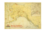
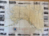
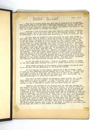
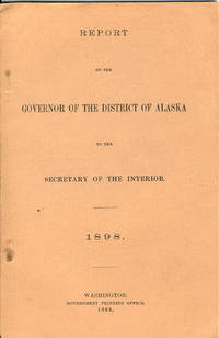
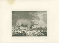
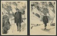
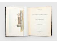
1885186340Washington DC: Government Printing Office 1885. First edition of the official United States government publication documenting the American contribution to the First International Polar Year of 1882 and 1883. The expedition departed San Francisco in July 1881 and established a long-term observing station near Point Barrow which remained in operation until 1883. The report records the practical realities of Arctic fieldwork including coastal and inland travel by sledge methods of construction and survival in polar conditions and the use of permafrost for storage. It also documents notable events of the expedition among them the loss of the whaling vessel North Star to the ice. The folding map illustrates the surveyed coastline and inland routes explored during the expedition. Quarto. Colour frontispiece 2 chromolithograph plates 10 photogravure plates lithograph plate 7 wood engraved plates 5 charts folding map. Original black cloth spine lettered in gilt boards ruled in blind. Bookplate of "Karl A. Pember". Ownership inscription of "James Moffitt" in black ink to front free endpaper. Spine toned with spot of wear gilt faded a couple of corners worn faint marks to covers front joint starting but firm minor foxing. A very good copy. Arctic Bibliography 7747 and 14292 for the Narrative; Casey Wood p. 530. hardcover
H389Washington Government Printing Office 1900. First edition large quarto 56th Congress 1 session report 1023. Half-calf over marbled paper covered boards. 51 reports and subreports of explorations made by U.S. army between 1869 and 1899 - possibly the most comprehensive documentation on these first three decades after the purchase of Alaska by the U.S. Numerous maps photographic plates and text-illustrations. As stated in the preface: "The reports of these explorations and reconnaissances of military explorers in Alaska are here for the first time presented in connected narrative form." Not a very common item in almost pristine condition! Collation: 1 nn leaf title-page crossed-out stamp of former owner Adriance Memorial Library Poughkeepsie N.Y. April 18 1901 - verso: Joint University Libraries Nashville Tenn. table of contents pp i-vii list of all the different reports preface 1 page introduction pp 5-16 text pp 21-825 index pp 827-851 index of indian tribes pp 853-856. Many very large folding-maps numerous photographs of unique documentary value lithograph-plates text illustrations. This wealth of historic illustrative material above all the original photographic plates make this book a treasure-box for the documentation of early Alaskan scenery native groups natural habitats! An ideal sourcebook for sub-polar ethnography topography as well as geography. hardcover
190054584Washington Governemnt Printing Office 1900. Large 4to. Orig. red full cloth. Gilt lettering on spine. Spine dusty. VII856 pp. textillustrations 33 plates and 27 folded maps. Internally clean and fine. hardcover
1943217811943. Civilian construction labor photo album documenting on the Alaska-Canada Military Highway during World War II one of the largest emergency infrastructure projects undertaken in North America during the war. The material records wartime military logistics federal civilian contracting and frontier transportation construction through photographs official permits military certifications and worker inscriptions connected to the rapid building of the ALCAN Highway in 1942-1943. Compiled by civilian laborer Paul Cecil Pemble an employee of Ferguson-Diell Construction Company the album connects private contractors federal agencies and the U.S. Army Corps of Engineers to the construction of a strategic military supply route linking the contiguous United States to Alaska following Japan's Aleutian Islands campaign. The archive provides primary-source evidence for wartime infrastructure mobilization civilian labor under military authority and the logistical expansion of defense systems in the North American Arctic frontier.<br /> <br /> Oblong string-tied photo album in original painted suede leather covers titled Alaska - Where the North Begins with embossed and hand-colored totemic decoration. Contains approximately 66 silver gelatin photographs ranging in size from approximately 4.5 x 3.25 inches to 10 x 8 inches alongside multiple official documents licenses permits correspondence and autograph pages. Included documents identify Paul Cecil Pemble as a civilian heavy equipment operator employed on the Alaska Highway project. These include a Public Roads Administration license issued under the Federal Works Agency dated June 29 1943; a U.S. Army Corps of Engineers certification dated August 4 1943 signed by First Lieutenant Colin L. Park authorizing operation of trucks tractors and wheeled scrapers; and an Alcan Military Highway Command permit dated August 19 1943 authorizing travel on the restricted military roadway. A typed letter from Tok Junction dated October 8 1943 confirms the extension of Pemble's Selective Service deferment due to essential wartime labor. Several opening pages titled "Memory Leaves" contain approximately sixty signatures and inscriptions from fellow workers many identifying hometowns in Iowa and including humorous remarks and nicknames such as "Cook" "Butch" and "Alaska Thunderbolt." The photographs extensively document construction activity and camp life including bulldozers graders cranes timber bridge scaffolding military truck convoys wrecked vehicles stranded in ditches muddy roadbeds and large encampments of prefabricated structures. Multiple images show men constructing river crossings operating machinery and posing in work clothes beside heavy equipment. Additional photographs depict interior bunkhouses mess hall scenes with workers gathered around tables and a large group portrait of more than fifty civilian laborers posed before a treeline. Wildlife and recreation also appear throughout the album including black bears scavenging through refuse fishing scenes with large catches displayed by workers dogs resting beside snowy roads and Pemble's trailer quarters attached to the back of a truck. The final pages include panoramic camp views and directional signpost photographs listing construction companies and distances to Fairbanks Whitehorse and multiple contractor camps along the route.<br /> <br /> The album records the logistical effort required to construct the Alaska Highway across remote and environmentally severe terrain during wartime emergency conditions. Built in response to fears of Japanese expansion into Alaska and the North Pacific the highway became a critical military supply corridor linking airfields fuel depots transport infrastructure and defense installations across Alaska and western Canada. The album focuses on civilian laborers operating within military-controlled systems including contract workers represented through photographs permits deferment documents and personal inscriptions. The combination of photographs permits deferment documents and personal inscriptions records daily life labor conditions and federal wartime administration on the ALCAN project. Photographs mounted cleanly to black paper leaves with corner tabs; occasional light creasing and minor wear to several prints. Leather covers lightly rubbed but structurally sound and visually bright. Overall very good condition. A documentary archive of civilian wartime labor and military infrastructure construction during one of the most ambitious engineering projects of the Second World War. unknown
189729536New York 1897. Broadsheet 9 1/2" x 12". With a small oval half-tone portrait. On recto at the bottom printed in red: 'Norton Hall Granville N.Y. Thursday Eve. Dec. 30 1897.' Near Fine.<br /> <br /> A rare announcement of a public entertainment-- "Not a Lecture. But a Budget of Jewels Sparkling Pathetic Humorous and Original"-- by this popular Western hero who on his first outing as a reporter in 1875 promoted the Black Hills Gold Rush. John W. Crawford 1847-1917 was a "poet-scout" who memorialized Custer and Wild Bill Hickok in verse. He "was one of the original discoverers of gold on French Creek in the Black Hills in 1876." After a stint with Buffalo Bill's Wild West Show which he left when he accidentally shot himself in the groin blaming it on Buffalo Bill's drinking he moved to New Mexico to scout for the Army against the Apache. He "did more than any other man in the Territory in bringing before the public the immense mineral wealth of New Mexico."<br /> This broadsheet not only publicizes Captain Jack's Entertainment but also promotes "The Capt. Jack Crawford Alaska Prospecting and Mining Co." Testimonials to Crawford are printed here along with an invitation for the recipient to receive a Company prospectus.<br /> OCLC 778631567 3- Yale SMU U AK as of February 2023. unknown
1945191491945. Unidentified compiler photograph album of United States Army troops stationed near Seward Alaska circa 1945 documenting military life and operations in a strategic northern deployment during the closing period of World War II. The material provides primary visual evidence of troop activity infrastructure development and social life within a remote military environment supporting research into wartime logistics soldier experience and the role of Alaska in U.S. military defense during the conflict.<br /> <br /> Photograph album containing 58 black and white silver gelatin prints most measuring approximately 3.5 x 6 inches depicting soldiers engaged in both formal and informal activities. Images include groups of men standing at attention with rifles constructing wooden buildings in rugged terrain and participating in daily routines within camp settings. A series of photographs documents a dance event for troops featuring a jazz band with music stands marked "153" alongside an emblem suggesting a possible connection to the 153rd Infantry Regiment which was stationed in Alaska during the period. Additional images show steamships including the S.S. Baranof S.S. Alaska S.S. Denali and S.S. Columbia navigating the Inside Passage and areas near Taku Glacier indicating transportation and supply routes. The album also contains a "memory leaves" section with handwritten notes and addresses from fellow servicemen reflecting interpersonal networks and efforts to maintain contact beyond deployment.<br /> <br /> 58 photographs mounted in an album with decorated leather covers featuring a hand-painted image of Alaskan sled dogs titled "The Malamute Limited." During World War II Alaska served as a critical military zone due to its geographic proximity to the Pacific theater with troop deployments focused on defense infrastructure and logistics in challenging environmental conditions. This album captures both operational and social dimensions of that presence including labor recreation and movement through the region. Light handling wear to album and photographs contents well-preserved; overall very good condition. A cohesive and detailed visual record of U.S. Army life in wartime Alaska. unknown
4499KODIAK ALASKA HUNTING PHOTOGRAPH ARCHIVE. An archive of nearly 100 black and white photographs emanating from a mens hunting trip to Kodiak Alaska about 1950. There are images of men with fishing rods and rifles and dead bears crabs fish moose and seals. Some photographs show the men inside the cabin relaxing reading sleeping and cooking. There are also photographs of the early planes that brought tourists Alaskan scenery and small Alaskan towns. The images are in three sizes 5 x 7 5 x 3 and 2 x 4 and all are in fine condition with minor faults such as chipped corners. A fine frontier photography archive. unknown
1939286138Seattle: Farwest Lithograph and Printing Co 1939. Map. Color Lithograph. 21" x 28".<br/> <br/> This beautifully colored map of Alaska and the Gulf of Alaska shows the Alaskan boat lines from Seattle and was first drawn by Edward Camy for the Alaska Steamship Company in 1934. A great pictographic map includes an inset showing the Alaska Railways route from Seward to Fairbanks and the Richardson Automobile Highway. The bottom of the map shows a series of cartoons of events on the ship. In good condition a great example of Alaska.<br/> <br/> Farwest Lithograph and Printing Co unknown
19303726Juneau Ak.: Winter & Pond 1930. Good. Panoramic photograph 10 x 34.5 inches. A few heavy creases a handful of short closed tears minor surface soiling and rubbing. An early-20th century panoramic image showing the development of the Alaskan capital city of Juneau produced by prolific local studio Winter & Pond. The image features the downtown portion of Juneau complete with paved streets telephone and electrical wires and hundreds of houses set between nearby Mount Juneau and the Gastineau Channel. <br /> <br /> "Lloyd Winter and Percy Pond preserved the legacy of Alaska's past through their photographs taken over a period of 50 years. The studios of Winter and Pond Company in Juneau Alaska provided local residents and visitors with a rich perspective of Alaska that is now considered a unique reflection of the state in the early 20th century. During the company's existence Alaska expanded mining fishing and resource development into profitable ventures that transformed it from a frontier district to a thriving territory of the United States. The portraits that Winter and Pond produced show the diversity of Alaska's people through the years from the gold rush of the Klondike in 1898 to the end of the mining operations in the Juneau Gold Belt District during the 1940s" - Alaska State Library's Historical Note for the Winter and Pond Collection. <br /> <br /> OCLC reports a few different Winter & Pond views of Juneau from 1909 to 1928 with the present example likely dating from a bit later but nonetheless rare. Winter & Pond unknown
1942218151942. Photograph archive circa 1920s-1944 documenting the construction of the Alaska Highway and related military infrastructure during World War II. The material records wartime military logistics and infrastructure development through photographs of road construction engineering operations heavy machinery and military transport routes in Alaska and western Canada during the war. The photographs include terrain modification machinery deployment bridge construction and coordinated labor by military and civilian crews working under wartime conditions.<br /> <br /> Archive comprises 30 black-and-white photographs including approximately 21 captioned images issued by the Public Roads Administration and War Information Board dating from circa 1942-1944 alongside 10 earlier vernacular snapshots from the 1920s-1930s. Sizes range from approximately 2.5 x 1.5 inches to 5.5 x 3.5 inches. Official photographs depict graded roadways cutting through mountainous and forested terrain heavy machinery including tractors and graders clearing timber and earth and crews working in challenging conditions such as permafrost excavation. Several images show pontoon bridges early roadbeds and military vehicles including jeeps and convoys positioned along newly constructed routes. Captions reference wartime labor and engineering activity. Vernacular photographs depict earlier regional life including individuals traveling by sled posing with fish working in sawmills and operating equipment. Additional scenes include a Chinese barber shaving a client and frontier couples posed outdoors with handwritten verso captions referencing locations such as Juneau and Valdez.<br /> <br /> The photographs record the rapid development of the Alaska Highway following the strategic urgency created by World War II particularly after the attack on Pearl Harbor and military concerns in the Aleutian region. Official photographs focus on wartime infrastructure projects while the vernacular photographs record prewar labor and daily life in Alaska and the Yukon. The archive includes military construction transportation systems sawmill labor travel and regional commercial activity before and during wartime expansion. Light curling and handling wear to vernacular photographs; minor edge wear and occasional markings to official prints; overall very good condition. A visual archive of wartime engineering and northern frontier life during a period of military expansion. unknown
1945215781945. AArchive of 64 original black-and-white photographs documenting American military operations and engineering activities in the Aleutian Islands during World War II. Photographs measure approximately 4.5" x 3.5" and provide an extensive visual record of one of the most remote and environmentally challenging theaters of the war. The images chronicle the daily work of U.S. Army personnel and Army Engineers stationed across the Aleutian chain where military forces confronted not only the threat of enemy action but also some of the harshest conditions faced by American troops anywhere during the conflict. Soldiers appear throughout the archive wearing cold-weather gear field jackets heavy boots and M1 steel helmets while working patrolling and constructing infrastructure amid windswept volcanic landscapes.<br /> <br /> A significant portion of the collection documents the enormous logistical effort required to sustain military operations in the islands. Engineers are shown surveying terrain operating equipment cutting and processing timber and building facilities essential to maintaining isolated military outposts. Several striking photographs depict large timber-log chutes descending steep hillsides toward the shoreline apparently designed to move heavy equipment and supplies through terrain where conventional transportation proved difficult. Other images record lumber operations construction projects and the continual adaptation of military infrastructure to the rugged environment. The archive also contains numerous panoramic views of the Aleutian landscape itself. Snow-covered mountains barren volcanic ridges isolated coastlines glacial valleys and treeless tundra dominate many photographs illustrating why the campaign became as much a battle against geography and weather as against enemy forces. The Aleutian chain stretching deep into the North Pacific and containing dozens of active and dormant volcanoes represented one of the most isolated regions under American military control during the war.<br /> <br /> Naval and maritime operations are likewise represented. Several photographs show transport and supply vessels anchored offshore or approaching remote coastal installations highlighting the dependence of Aleutian bases upon sea-borne logistics. Military camps consisting of Quonset huts and tent encampments appear throughout the collection while one particularly notable image captures an aircraft flying above a military installation underscoring the importance of aerial reconnaissance and patrol operations in protecting the northern approaches to Alaska. Although often overshadowed by campaigns in Europe and the Central Pacific the Aleutian campaign held considerable strategic importance. Following the Japanese occupation of Attu and Kiska in 1942 American forces undertook a costly effort to secure the islands and maintain control of the northern Pacific. These photographs document the infrastructure manpower and determination required to operate in a theater where extreme weather isolation and difficult terrain shaped every aspect of military life. A substantial and visually compelling archive documenting the engineering logistical and environmental realities of America's northernmost front during World War II. Photographs remain in very good condition with minor surface wear and occasional light creasing. unknown
191737386Chicago: Poole Bros. 1917. 1917. ALASKA. First edition. A full-color folded map of Alaska showing both the coastal and seagoing routes that leave from Seattle to Alaska by the Alaska Steamship Company. Points of interest are indicated in red and include the Klondike Region Fairbanks Gold Placers Mt. McKinley National Park Kennecott Copper Mines etc. In the upper right corner is an 11" x 8" inset black & white map of the Copper River & Northwestern RY. and the Alaska Railroad showing Copper River Region in Alaska Prince William Sound the Richardson Automobile Highway Mt. McKinley National Park and Government Telegraph Line and Tributary Territory. Map has a few tears at folds some soiling to the map's surface and general wear from handling and use. Overall a good map of Alaska. Poole Bros., 1917. unknown
1966233371966. Cook Inlet offshore drilling photo archive of 57 chromogenic color photographs documenting the transport assembly and field operation of oil platform equipment in Alaska in 1966 including derrick sections drill pipe draw works components service trucks staging yards flare fire and rig floor assembly during the period when offshore construction expanded rapidly across the basin between 1964 and 1968. Alaska's first offshore platform was erected in Cook Inlet in 1964 exploration drilling peaked in 1966 and the photographs place the group within the short formative period when Cook Inlet became the proving ground for Alaska's offshore petroleum industry. The photographs record named individuals large platform components drill pipe derrick sections service trucks and specialized machinery moving from yard to worksite and from transport into operation.<br /> <br /> Photo archive of 57 chromogenic color photographs Kodacolor snapshot prints ranging from 3.5 x 3.5 to 3.5 x 4.5 inches Cook Inlet Alaska 1966. The derrick and draw works sections are hauled on heavy trucks across dirt roads rig components unloaded in open staging yards drill pipe rising within the derrick structure and crews in hard hats and work clothes working at the base of drilling machinery. Several photographs isolate specific stages of petroleum work rather than completed structures including a float identified on the verso as "Flatt & Doghouse" a "Tool box & work area on float" machinery captioned "Unloading Draworks from our truck #103 to Gary Bobs Road truck" pipe identified as "13000 ft pipe in deric" and repeated views of muddy haul roads flare fire active equipment and rig floor assembly from both elevated and ground level vantage points. The versos preserve contemporaneous functional captions and named personnel including "Front view with Jerry Blackwood driving" "Little Red & Ramdro discussing plans" "Putting Deric on the floor" "two trucking the Deric" "Bottom 1/2 of the Deric. This is the way we haul it" and "My truck hauling top 1/2 deric pulled over for the day too muddy to proceed to location" giving the archive unusual specificity at the level of individual labor and task sequence. A yard sign for Canadian Superior places part of the group within the corporate landscape of Cook Inlet petroleum development.<br /> <br /> Cook Inlet's offshore fields were the first large scale petroleum infrastructure projects in Alaska waters and the photographs preserve the hauling stages yard transfer pipe handling rig erection truck transport and field conditions through which the basin moved from exploration into sustained production. Named workers truck numbers hauling stages yard transfer pipe handling rig erection and field conditions place the group within the daily labor structure of offshore oil development rather than in finished platform views alone. The seller's Spurr attribution merits caution since later platform compendia place Platform Spurr in Trading Bay in 1968 but that discrepancy does not alter the archive's value as a 1966 record of Cook Inlet drilling logistics and offshore construction practice. Front surfaces show scattered paper residue or adhesion from prior storage with light wear minor discoloration and ordinary handling marks. Overall good condition. A 1966 Cook Inlet drilling archive centered on truck haulage derrick assembly pipe handling named workers and offshore construction logistics during the basin's first major oil boom. unknown
1917List1730Chicago: Poole Brothers 1917. Folding map measuring 38 ½ x 26 ¾ inches. Tape repairs to verso some tears at folds and edges still bring and attractive good to very good overall with excellent restoration potential. A map of the canneries in Alaska British Columbia and Washington operated by the Deming and Gould Company who were influential in the growth of the Alaskan salmon trade. The map’s date of printing 1917 suggests that perhaps it was related to the war effort as salmon demand increased during this period. The Demings based in Chicago were influential in the growth of the salmon trade in Alaska and the Pacific Northwest founding Pacific American Fisheries Inc. in 1899 and continuing in various iterations until their sale of the firm in 1934 due to president E.B. Deming’s ailing health. The map shows seventeen different canneries several on the Alaska peninsula and the one in Bellingham. We find no record of this imprint only a later and small version held at the University of Washington. Poole Brothers unknown
74398Typescript account of 32 pages accompanied by 31 black and white photographs gathered in a scrapbook album documenting an unidentified Washington’s man’s hiking climbing and sight-seeing adventures in Alaska. Written along the top edge of the first page is “Alaska Bound 1946-1947.†Twenty-three of the onion skin paper pages are scotch taped to the album pages and the final nine pages of the typescript are loose and laid into the back of the string-tied album. The black and white photographs measure 4 ½ x 2 ¾†and are affixed to the album pages with black photo corners. The tape affixed to the pages has oxidized but otherwise overall on very good condition.<br/> <br/> The unknown author was a crewman on a cargo ship and wrote that he had made more than 150 prior trips to Southeastern Alaska. On this trip his ship set out from Seattle to the Aleutian Islands and made a stop at Anchorage to drop off some dogs for the Army. “As part of the cargo which we were carrying we had on deck sixty-one sled dogs raised in Nebraska†he wrote. “They were supposed to be mostly huskies but in reality were a mixture of almost everything…It was remarked: ‘They are nothing but a darned bunch of Nebraska coyotes.’â€<br/> <br/> Beyond Anchorage the ship’s itinerary included Adak Attu Shemya Whittier and Amchitaka. The narrative covers his experiences on board but is mainly devoted to his shore adventures oftentimes with other members of his crew which include mountain climbing hiking fishing trips and sight-seeing during his free days while cargo is being off loaded. One of his first adventures was a trip to Wasilla and Palmer. “Back in Palmer once more we made the acquaintance of one of the old timers who gave us quite a history of Alaskan mining from the early gold rush days up to the present time†he wrote. “He tried to persuade us to go back into the mountains with him to take pictures of his claims.<br/> <br/> On the way to Adak he spotted “whale birds†and soon whales were also seen. “During the war whales in these waters were frequently attacked by both bombers and submarines in error†he wrote. “It was it seems difficult to detect the difference between submarines and whales.â€<br/> In addition to being an avid and skillful storyteller and photographer the diarist had a wide-ranging knowledge and interest in the flora and fauna of the region. During a port stop in Attu he explored Holty Holtz Bay and traveled to the summit of Jarmin Pass where the Japanese once maintained a principal base until it was recaptured by the United States during World War II. “In the foreground and also in the distance some dummy guns and other equipment could be seen scattered about†he wrote. “I followed along the stream and before long came across a few small willow bushes less than three feet in height bravely struggling for existence against the elements. They were located in a thicket of Russian thistles wild cherry tanzzy monk hood and numerous other kinds of vegetation. That was my first glimpse of anything in the form of wood growing in the Aleutians.â€<br/> <br/> On this break he undertook the first of several climbing expeditions – this one of Gilbert Ridge. It was a near catastrophe after the weather turned foggy while he was climbing the jagged peaks made the wrong decision dead-ending against sheer cliffs and fell while back tracking his route. “In that next instant I found myself bouncing over the wet cozy ground like a toboggan over a snowbank…I started flying through space at what seemed to me a mile a minute. In the next instant there was a big swoosh as I cut a path three feet wide and five feet long through a patch of Indian celery Russian thistle and Monk’s Hood and landed with a flop in the creek bed below and that was that.†Although he was fortunate to escape with a sore shoulder and sprained thumb he was soaking wet and faced a long journey back to the ship.<br/> <br/> The scrapbook is filled with numerous descriptive accounts of his adventures during the journey. The photographs complement the text and include various images of his explorations ranging from Whittier Glacier to two men holding a crippled Bald Eagle a trading store in Wasilla and fishing at Finger Arm. At the end of the trip before returning to Seattle he and his shipmates went into the woods and cut Christmas trees which they delivered to families on the treeless remote Aleutians. unknown
1918137331San Francisco: International Printing Co. 1918. Undetermined. very good. Colour calendar on heavy cardstock. 21" X 14". Occasional very light chipping and to edges. Corners bumped with some creasing. A few other light creases to edges. Full calendar pad Jan - Dec present with penciled notation in most days. Original string hanger present. Colours bright and unfaded. This poster is in very good condition. A scarce advertising calendar for the Northern Commercial Company N.C.Co. a retail company which maintained rural village stores across Alaska and in the Yukon. N.C.Co also operated steamships through Alaskan trade routes. The image on the poster features mining at Iditarod Alaska. Two totem poles on either side of the calendar pad list several stations of the N.C.Co. including Fairbanks Dawson Yukon Territory Bettles Iditarod and many others. The verso of the calendar is a full-page map of Alaska showing sea routes and locations of N.C.Co posts. A later incarnation of the business still maintains 30 stores across rural Alaska. See two other examples in this catalogue. 1918 International Printing Co. unknown
SONG1591981247Creative Teaching Press 0000-00-00. paperback. Used: Good. 9.00x0.25x11.25. Buy with confidence. Excellent Customer Service & Return policy. Creative Teaching Press paperback
189832865Washington: Government Printing Office 1898. 1898. First edition. 8vo. Salmon-colored printed wrappers 49 pp. map. Large portion of the report deals with more effectually carrying out the law prohibiting the sale of intoxicating liquors in Alaska. Mention is made of a tribe on the Admiralty Island known as the "Hoochinoos" who used to smuggle to the soldiers at Sitka a beverage known as "hoochinoo" and "hooch." "Hooch" was made from a mash of black molasses imported from the Hawaiian Islands. Smuggling and the control of smugglers is of great concern to the law as well as effectively enforcing the laws to protect both saloon keepers and the citizens. The governor further reports on criminal and penal laws land laws population taxable property agricultural development stock raising reindeer fur seals sea otters mining etc. Disasters are included in the report with the mention of the schooner Lady Jane Grey that went down off Cape Flattery with only a few saved. A map of the longitudinal section of workings of the Alaska/Mexican Gold Mine is also present. A fine clean copy. WICKERSHAM 227. Government Printing Office, 1898. unknown
190375062London: McCorquodale 1903. First edition of this atlas map folio 16 1/4 x 27 1/2 inches. 5 sheets of British Commission maps and index map; 13 sheets of United States Commission maps Alaska boundary atlas and index map. Total of 20 maps 19 folding and 5 in color Maps are 53 x 32 inches. All but the British index map folded and backed in linen. Quarter red morocco over red cloth. Gilt Royal Seal to front board and spine. Maps mounted on linen and sectioned as issued. Portfolio case with moderate rubbing chipping to leather. Does not include the 10 cards to accompany the U.S. Commission maps seems to be common that these smaller ones are missing. Old staining to cloth. Toning and edge wear to British Index map. Slight toning and offsetting to maps. Overall a very good copy; quite scarce. [McCorquodale] hardcover
190455454London: Rowland Ward Ltd. 1904. Tall 8vo. xvi 292 pp. plus 2 pp. publisher’s ads. Photo frontisp. 44 photos and plates 1 large folding map in rear pocket. Green publisher’s cloth gilt lettering front cover & spine simulated Zebra skin endpapers minor bumping to corners edgewear slight spotting on the spine still VG copy. First edition of this excellent early account of hunting on the Kenai Peninsula including descriptions of Alaskan Native Americans salmon cannery operations and more. Radclyffe had acquired a permit from the Bureau of Biological Survey with the USDA in order to collect big game specimens for the British Museum and the account was dedicated to a longtime fellow hunter and friend Theodore Roosevelt. The author details his experiences with hunting Alaskan Brown Bears Grizzly Bears Moose Dall Sheep and running afoul of the zealous US Deputy Marshal Sexton a stickler for the new game regulations instituted on the Kenai in 1903 not to mention destroying the distilling operation of Alaskan hunter & miner Andrew Berg. He managed to survive a charging bear sow after being abandoned by his guide as well as the Alaskan courtroom but his companions were not so lucky as the judge ruled that the permit did not extend to the hunting party. Radclyffe returned later to hunt Alaska on the Kenai in August 1910 employing Andrew Berg as his head guide. See: Catherine Cassidy Alaska’s No. 1 Guide: The History and Journals of Andrew Berg 1869-1939 pp. 28-29 38. Rowland Ward Ltd., hardcover
188076162Washington:: Government Printing Office 1880. Second Edition -- With Charts. publisher's lettered cloth. Cloth worn at the spine and extremities but tight and sound; contents apart from the vertical splits mentioned above fine. . Folio. Four charts in pocket at rear of volume. Printed "Compliments" slip of Sheldon Jackson U. S. General Agent of Education in Alaska tipped onto the title page. The collectors of the materials recorded in the Schedules were E. S. Smith assisted by William J. McDonnell Winter 1892 and 1893. There are Aleutian words and phrases recorded in ms. on dozens of pages; and in addition illustrations of a side view and ground plan of a native Western Alaskan house with detailed description; drawings of characteristic features of Eastern and Western Alaskan natives snowshoes boats paddles etc. Two of these illustrated descriptive pages have neat vertical splits not affecting legibility. Government Printing Office, hardcover
178529434London 1785. Copper engraved images of Alaska & Vancouver Island from the folio atlas of Cook's 3rd voyage Pacific Ocean exploration. The plate numbers included are #40 41 48 49. 52 57 & 73. Two images are of Alaskan natives their boats and huts going about their daily lives. <br /> Sea Horses refers to seals and the white polar bear is majestic. Two with a corner waterstain one with a slight brown circle in the margin one with marginal foxing. <br /> Paper sizes 21.5 x 16.25" and one is 22 7/8 all with wide margins. Some light marginal dusting overall very good condition. unknown
1917List3507Alaska 1917. Photo album measuring 7 ¼ x 11 ½ inches containing 187 photos 2 unaffixed and five loose real photo postcards with a contemporaneous newspaper clipping. Photos approximately 3 x 4 inches with generally excellent contrast and in Near Fine condition. Overall excellent to Near Fine. A photo album belonging to brothers Ruben 1892–1984 and Daniel 1895–1969 Diener documenting their 1916–1917 journey to the Territory of Alaska. The newspaper clipping reproduces a letter from Dan Diener describing their time there:<br /> <br /> “I went with an old prospector to try and locate a lost mine. We found it but there was not enough gold to pay for mining it so in that respect our trip was a failure. . I lived in a tent with a small sheet iron stove during all this time and strange as it seems it was fairly comfortable. . One day I walked or snowshoed 30 miles for my mail when the thermometer was 58 below. . But the hardships were sweetened at times with the most beautiful scenery man can imagine.†March 1917<br /> <br /> The Dieners’ trip took them to Alaska’s southern coast to Ketchikan Cordova Valdez and Seward. There are some identifiable ships including the Admiral Farragut the Mariposa shortly before its sinking and the wreck of the James Drummond in British Columbia.<br /> <br /> Subjects include Chief Johnson’s totem pole in Ketchikan erected in 1902 in honor of Chief Gut Wain George Johnson; d. 1938 of the Gaanaxadi clan of the Tongass tribe—a real photo postcard from Kasaan shows many brightly colored totem poles along the shore with dilapidated wooden houses behind them—boats filled with fish outside the Carlisle Packing Company in Cordova and a real photo postcard of a man and dog captioned “READY FOR THE SUMMER TRAIL / SEWARD ALASKA†on the back of which Ruben Dieners has written:<br /> <br /> “Oct 9 1916. Here you are. This is Judge Hildreth of whom we have written you. Our best friend here and hereafter. We are going prospecting with him next spring. The dog in the picture carry’s fifty pounds. Brother Ruben.â€<br /> <br /> H.H. Hildreth was a district court commissioner in Seward editor of the Alaskan newspaper in Sitka and The Alaska Prospector in Valdez and secretary of the Matanuska Mining Company. <br /> <br /> The shots of towns show the development of the region: in some an area of forest has been recently cleared and stumps of trees might surround a few small wooden houses or platforms where houses are to be erected; while others show towns with telegraph lines graded dirt roads with sidewalks dense housing and railroad and tram lines. Two shots from Seward show the paved sidewalk of its main street with a hotel and bars and a dog team waiting outside the hardware store. As Dieners wrote they lived in a tent and several photos show the outside of the quarters: two semi-permanent canvas tents next to a wide wooden walkway. Others show men presumably the brothers snowshoeing hiking and riding in a canoe; and of course many are scenery shots of forests waterfalls and snowcapped mountains.<br /> <br /> Of interest to historians of post-gold rush Alaska. unknown
19145195Various locations mostly in Canada and Alaska 1914. Very good plus. 36 leaves illustrated with 147 vernacular photographs and real photo postcards almost all with manuscript captions written in white pencil. Oblong quarto. Contemporary black textured cloth with "Photographs" in gilt on front cover and with handwritten caption in white pencil reading "1914 July 16 August 31." Minor wear to covers. Contents clean with easily-readable captions. A well-annotated vernacular photograph album assembled by F.A. Patterson of Arlington Heights Massachusetts documenting his or her travels through western Canada and Alaska just prior to World War I. The album opens with a small printed map of North America with the route Patterson took from "Boston to Alaska" between July 16 and August 31 1914. The photographs begin with thirteen leaves featuring scenes in Ontario and Alberta including scenes of Lake Huron St. Mary's River Sault Ste. Marie Winnipeg "Ontario farms" Banff the town wildlife mountain scenes and more Lake Minnewanka Lake Louise Laggan Valley of the Ten Peaks Morain Lake and more. The album then moves westward to British Columbia and other points then northwestward to Alaska for most of the remainder of the album. The westward photos open with scenes of the Illecillewaet Glacier Meeting of the Waters Trail Glacier and other locations in British Columbia. Scenes in Victoria picture various gardens Parliament Hotel Empress Chinese Bell and more. The scenes in Alaska begin with views of Taku Glacier and other scenes in and around Juneau. Other Alaskan images feature Lake Bennett several scenes in White Pass a view toward Skagway abandoned buildings Pitchfork Falls Sitka the harbor a "Russian Greek Church" a view of the town "Old Russian Black House" several totem poles including a "Totem Pole Patch" two angles of an "Old Russian Trading Post" and more. A particularly interesting pair of images of two buildings pictures what is left of Bennett Alaska which is captioned: "Formerly 5000 population. Now 4 houses. One occupied. August 5th 1914." The final few pages of Alaskan images features an Indian Village in Killisnoo and another in Hunter Bay as well as a close-up view of a group of indigenous peoples in Hunter Bay. The last five leaves capture scenes in Salt Lake City Utah and Colorado mostly Pike's Peak and Royal Gorge. unknown