Segregated Jim Crow FloridaBiblio.com
403 résultats
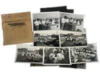
1951229201951. Jim Crow Florida Segregated public facility photograph archive from Clearwater Florida by George Fulmer 1951. Collection consists of 14 photographs including 7 black-and-white photographs and 7 associated film negatives documenting African American children in a newly opened library and schoolyard as well as a segregated swimming-pool planning meeting attended by city officials. Produced by George Fulmer Clearwater's longtime municipal photographer and WWII U.S. Navy enlisted photographer these images survive in their original studio proof envelopes from the George Fulmer Estate recovered after the 2014-2015 demolition of the Fulmer Studio which had stood beside the Clearwater Courthouse for over 65 years. The photographs measure 3.5" x 5" and the negatives are on Kodak safety film measuring 4" x 5" each. <br /> <br /> This archive captures two deeply revealing moments in the segregated civic history of mid-century Florida. The first packet labeled and dated to summer 1951 presents five photographs of Black schoolchildren reading playing circle games outdoors and participating in early library programming clear evidence of segregated educational resources but also of Black childhood joy and community-building within constrained circumstances. A white librarian or teacher is visible at the front of the classroom underscoring the racialized hierarchy embedded in Florida's school system prior to Brown v. Board of Education in 1954. The second packet likely taken only weeks apart based on Fulmer's original numbering system documents a group of white and Black men gathered around architectural plans for a segregated municipal swimming pool. The interracial nature of the planning body illuminates the complex often unequal negotiations around public development in Jim Crow Florida where recreational segregation remained legal until at least 1954-1955. These photographs represent an unusual visual record of the bureaucratic process behind segregated facilities.<br /> <br /> As part of the vast body of more than 100000 photographs preserved from Fulmer's studio much of which was claimed by the local historical society this small group represents a scarce surviving fragment of Clearwater's visual civic record with Fulmer's estate retaining a curated exhibition core and only limited dispersal of individual images. Fulmer documented weddings police activities construction projects civic events and wartime subjects but photographs relating to segregated facilities especially of Black children and community spaces are extremely limited in the archive. These images therefore constitute an important resource for researchers of Jim Crow Florida Black educational history municipal segregation and postwar Southern urban development. Photographs and negatives are crisp and clean only expressing minimal edge wear. Original Fulmer Studio proof envelopes present annotated in pencil with job numbers and subjects. Comes with two certificates of authenticity from the Fulmer estate. Overall very good condition. unknown
191740715Washington D.C.: Published by the United States Coast and Geodetic Survey 1917. Large folding nautical chart printed on heavy paper stock. Colored. Rare original coastal survey of the entrance to Tampa Bay including Anna Maria Island Bradenton and Fort De Soto Park.<br/> <br/> Established by President Thomas Jefferson in 1807 as the Survey of the Coast the U.S. Coast and Geodetic Survey was the United States' first civilian scientific agency. This agency has followed its mission to survey the U.S. coastline create nautical charts of the coast and help increase maritime safety since its founding and has often played fascinating roles in significant chapters of U.S. history. It served in all theaters of the Civil War in the service of the Union Army and Navy pioneered acoustic exploration in the wake of the sinking of the Titanic and during WWI it worked to detect enemy submarines. In addition this agency worked to survey and produce detailed maps and renderings of the U.S. coast. These nautical survey maps commonly referred to as "T-sheets" provide fascinating insights into the history of the United States coastline which has and will continue to shift. These maps are the most important data source for understanding the physical and ecological characteristics of the U.S. shoreline. The present map is a highly detailed and accurate sea chart of the Tampa region and an important historical view of a developing Florida. Published by the United States Coast and Geodetic Survey unknown
192140685Washington D.C.: Published by the United States Coast and Geodetic Survey 1921. Nautical chart printed on heavy paper stock. Colored. A rare coastal survey of Florida from Fernandina to Jacksonville including Amelia Island Atlantic Beach Neptune Beach and the St. Johns River.<br/> <br/> Established by President Thomas Jefferson in 1807 as the Survey of the Coast the U.S. Coast and Geodetic Survey was the United States' first civilian scientific agency. This agency has followed its mission to survey the U.S. coastline create nautical charts of the coast and help increase maritime safety since its founding and has often played fascinating roles in significant chapters of U.S. history. It served in all theaters of the Civil War in the service of the Union Army and Navy pioneered acoustic exploration in the wake of the sinking of the Titanic and during WWI it worked to detect enemy submarines. In addition this agency worked to survey and produce detailed maps and renderings of the U.S. coast. These nautical survey maps commonly referred to as "T-sheets" provide fascinating insights into the history of the United States coastline which has and will continue to shift. These maps are the most important data source for understanding the physical and ecological characteristics of the U.S. shoreline. The present map is a highly detailed and accurate sea chart of the Florida coast from Fernandina to Jacksonville and is an important historical view of the state. Published by the United States Coast and Geodetic Survey unknown
192140696Washington D.C.: Published by the United States Coast and Geodetic Survey 1921. Large folding nautical chart printed on heavy paper stock. Colored. A rare coastal survey of Florida from Fernandina to Jacksonville including Amelia Island Atlantic Beach Neptune Beach and the St. Johns River.<br/> <br/> Established by President Thomas Jefferson in 1807 as the Survey of the Coast the U.S. Coast and Geodetic Survey was the United States' first civilian scientific agency. This agency has followed its mission to survey the U.S. coastline create nautical charts of the coast and help increase maritime safety since its founding and has often played fascinating roles in significant chapters of U.S. history. It served in all theaters of the Civil War in the service of the Union Army and Navy pioneered acoustic exploration in the wake of the sinking of the Titanic and during WWI it worked to detect enemy submarines. In addition this agency worked to survey and produce detailed maps and renderings of the U.S. coast. These nautical survey maps commonly referred to as "T-sheets" provide fascinating insights into the history of the United States coastline which has and will continue to shift. These maps are the most important data source for understanding the physical and ecological characteristics of the U.S. shoreline. The present map is a highly detailed and accurate sea chart of Florida from Fernandina to Jacksonville and an important historical view of the developing state. Published by the United States Coast and Geodetic Survey unknown
192140700Washington D.C.: Published by the United States Coast and Geodetic Survey 1921. Large folding nautical chart printed on heavy paper stock. Colored. A rare coastal survey of Pensacola Bay including Perdido Key Pensacola and Pensacola Beach.<br/> <br/> Established by President Thomas Jefferson in 1807 as the Survey of the Coast the U.S. Coast and Geodetic Survey was the United States' first civilian scientific agency. This agency has followed its mission to survey the U.S. coastline create nautical charts of the coast and help increase maritime safety since its founding and has often played fascinating roles in significant chapters of U.S. history. It served in all theaters of the Civil War in the service of the Union Army and Navy pioneered acoustic exploration in the wake of the sinking of the Titanic and during WWI it worked to detect enemy submarines. In addition this agency worked to survey and produce detailed maps and renderings of the U.S. coast. These nautical survey maps commonly referred to as "T-sheets" provide fascinating insights into the history of the United States coastline which has and will continue to shift. These maps are the most important data source for understanding the physical and ecological characteristics of the U.S. shoreline. The present map is a highly detailed and accurate sea chart of Pensacola Bay and an important historical view of a developing Florida. Published by the United States Coast and Geodetic Survey unknown
192240699Washington D.C.: Published by the United States Coast and Geodetic Survey 1922. Large folding nautical chart printed on heavy paper stock. Colored. A rare coastal survey of Florida and Alabama around Pensacola Bay including Orange Beach Perdido Key Pensacola Pensacola Beach and Santa Rosa Island.<br/> <br/> Established by President Thomas Jefferson in 1807 as the Survey of the Coast the U.S. Coast and Geodetic Survey was the United States' first civilian scientific agency. This agency has followed its mission to survey the U.S. coastline create nautical charts of the coast and help increase maritime safety since its founding and has often played fascinating roles in significant chapters of U.S. history. It served in all theaters of the Civil War in the service of the Union Army and Navy pioneered acoustic exploration in the wake of the sinking of the Titanic and during WWI it worked to detect enemy submarines. In addition this agency worked to survey and produce detailed maps and renderings of the U.S. coast. These nautical survey maps commonly referred to as "T-sheets" provide fascinating insights into the history of the United States coastline which has and will continue to shift. These maps are the most important data source for understanding the physical and ecological characteristics of the U.S. shoreline. The present map is a highly detailed and accurate sea chart of the Pensacola area and an important historical view of a developing Florida. Published by the United States Coast and Geodetic Survey unknown
191640695Washington D.C.: Published by the United States Coast and Geodetic Survey 1916. Large folding nautical chart printed on heavy paper stock. Uncolored. A rare coastal survey of the Fort Myers area including the San Carlos Bay Caloosahatchee River Cape Coral Sanibel Island and Fort Myers Beach.<br/> <br/> Established by President Thomas Jefferson in 1807 as the Survey of the Coast the U.S. Coast and Geodetic Survey was the United States' first civilian scientific agency. This agency has followed its mission to survey the U.S. coastline create nautical charts of the coast and help increase maritime safety since its founding and has often played fascinating roles in significant chapters of U.S. history. It served in all theaters of the Civil War in the service of the Union Army and Navy pioneered acoustic exploration in the wake of the sinking of the Titanic and during WWI it worked to detect enemy submarines. In addition this agency worked to survey and produce detailed maps and renderings of the U.S. coast. These nautical survey maps commonly referred to as "T-sheets" provide fascinating insights into the history of the United States coastline which has and will continue to shift. These maps are the most important data source for understanding the physical and ecological characteristics of the U.S. shoreline. The present map is a highly detailed and accurate sea chart of Fort Myers area and an important historical view of a developing Florida. Published by the United States Coast and Geodetic Survey unknown
192140730Washington D.C.: Published by the United States Coast and Geodetic Survey 1921. Large folding nautical chart printed on heavy paper stock. Colored with minor wear. A rare original coastal survey of the south east Florida coastline from Biscayne Bay south of Miami to the northern tip of Islamorada including Key Largo Tavernier and Everglades National Park.<br/> <br/> Established by President Thomas Jefferson in 1807 as the Survey of the Coast the U.S. Coast and Geodetic Survey was the United States' first civilian scientific agency. This agency has followed its mission to survey the U.S. coastline create nautical charts of the coast and help increase maritime safety since its founding and has often played fascinating roles in significant chapters of U.S. history. It served in all theaters of the Civil War in the service of the Union Army and Navy pioneered acoustic exploration in the wake of the sinking of the Titanic and during WWI it worked to detect enemy submarines. In addition this agency worked to survey and produce detailed maps and renderings of the U.S. coast. These nautical survey maps commonly referred to as "T-sheets" provide fascinating insights into the history of the United States coastline which has and will continue to shift. These maps are the most important data source for understanding the physical and ecological characteristics of the U.S. shoreline. The present map of the Florida coastline shows part of the Overseas Railroad prior to its partial destruction and abandonment after a Hurricane in 1935. This map is a highly detailed and accurate sea chart of the Keys region and an important historical view of a developing Florida. Published by the United States Coast and Geodetic Survey unknown
191640724Washington D.C.: Published by the United States Coast and Geodetic Survey 1916. Large folding nautical chart printed on heavy paper stock. Colored. A rare original coastal survey of Florida from Tampa Bay to the Keys including Tampa St. Petersburg Sarasota Fort Myers Naples and of Northern Cuba including Havana.<br/> <br/> Established by President Thomas Jefferson in 1807 as the Survey of the Coast the U.S. Coast and Geodetic Survey was the United States' first civilian scientific agency. This agency has followed its mission to survey the U.S. coastline create nautical charts of the coast and help increase maritime safety since its founding and has often played fascinating roles in significant chapters of U.S. history. It served in all theaters of the Civil War in the service of the Union Army and Navy pioneered acoustic exploration in the wake of the sinking of the Titanic and during WWI it worked to detect enemy submarines. In addition this agency worked to survey and produce detailed maps and renderings of the U.S. coast. These nautical survey maps commonly referred to as "T-sheets" provide fascinating insights into the history of the United States coastline which has and will continue to shift. These maps are the most important data source for understanding the physical and ecological characteristics of the U.S. shoreline. The present map is a highly detailed and accurate sea chart of the Greater Florida Gulf region and an important historical view of a developing Florida. Published by the United States Coast and Geodetic Survey unknown
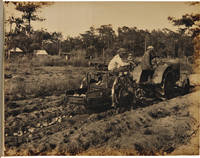
1920WRCAM54681Hastings Fl 1920. Two volumes. Eighteen sepia-toned photographs each approximately 7 1/2 x 9 1/2 inches. Oblong quarto. Contemporary black leatherette all photographs linen-backed and bound in on stubs. Mild shelf wear. Photographs in excellent condition. A very interesting pair of photo albums with large-format images featuring African- American field workers and other manual laborers working for Superior Brand New Potatoes in Florida in the early 20th century. The photographs were professionally produced by the Higginbotham Photo Company of Dallas Texas with their paper label affixed to the inside front cover of each album. Ten of the eighteen photographs feature African- American laborers in the fields on tractors posed outside the processing area or on trucks loading freight trains. Of the ten photographs four are unique examples and three are present in duplicate. In addition to the African-American workers several shots feature poor white laborers processing potatoes including one shot of workers using a Boggs Potato Grader. <br> <br> Hastings became the "Potato capital of Florida" in the early 1900s after Thomas Horace Hastings established a 1569-acre plantation to grow winter vegetables. Soon he switched to potatoes and by 1917 he enjoyed great success. Hastings remains an important agricultural center today serving as the packing and shipping center for a tri- county consortium of potato farmers with farms that also produce cabbage onions eggplant and other vegetables. hardcover books
191840712Washington D.C.: Published by the United States Coast and Geodetic Survey 1918. Large folding nautical chart printed on heavy paper stock. Colored. A rare original coastal survey of Florida from Jupiter to Tampa including West Palm Beach Miami Boca Raton Fort Lauderdale Miami the Keys and Fort Meyers as well as the Bahamas and a partial mapping of the northern Cuban coastline including Havana.<br/> <br/> Established by President Thomas Jefferson in 1807 as the Survey of the Coast the U.S. Coast and Geodetic Survey was the United States' first civilian scientific agency. This agency has followed its mission to survey the U.S. coastline create nautical charts of the coast and help increase maritime safety since its founding and has often played fascinating roles in significant chapters of U.S. history. It served in all theaters of the Civil War in the service of the Union Army and Navy pioneered acoustic exploration in the wake of the sinking of the Titanic and during WWI it worked to detect enemy submarines. In addition this agency worked to survey and produce detailed maps and renderings of the U.S. coast. These nautical survey maps commonly referred to as "T-sheets" provide fascinating insights into the history of the United States coastline which has and will continue to shift. These maps are the most important data source for understanding the physical and ecological characteristics of the U.S. shoreline. The present map is a highly detailed and accurate sea chart of Southern Florida and the Northern Caribbean region and an important historical view of a developing Florida. Published by the United States Coast and Geodetic Survey unknown
191740734Washington D.C.: Published by the United States Coast and Geodetic Survey 1917. Large folding nautical chart printed on heavy paper stock. Colored. A rare original coastal survey of Florida from Vero Beach to Jupiter including Fort Pierce Port St. Lucie Stuart and the Hobe Sound with an inset map of the Narrows in the upper left corner.<br/> <br/> Established by President Thomas Jefferson in 1807 as the Survey of the Coast the U.S. Coast and Geodetic Survey was the United States' first civilian scientific agency. This agency has followed its mission to survey the U.S. coastline create nautical charts of the coast and help increase maritime safety since its founding and has often played fascinating roles in significant chapters of U.S. history. It served in all theaters of the Civil War in the service of the Union Army and Navy pioneered acoustic exploration in the wake of the sinking of the Titanic and during WWI it worked to detect enemy submarines. In addition this agency worked to survey and produce detailed maps and renderings of the U.S. coast. These nautical survey maps commonly referred to as "T-sheets" provide fascinating insights into the history of the United States coastline which has and will continue to shift. These maps are the most important data source for understanding the physical and ecological characteristics of the U.S. shoreline. The present map of the Florida coastline was issued before the incorporation of Jupiter Township in 1925 and predates the development of Route 1. A railroad is marked as following the approximate route of the highway. This map is a highly detailed and accurate sea chart of the Jupiter region and an important historical view of a developing Florida. Published by the United States Coast and Geodetic Survey unknown
191740733Washington D.C.: Published by the United States Coast and Geodetic Survey 1917. Large folding nautical chart printed on heavy paper stock. Colored. A rare original coastal survey of the south eastern Florida coastline from Boca Raton to Jupiter encompassing Lake Worth West Palm Beach and Delray Beach.<br/> <br/> Established by President Thomas Jefferson in 1807 as the Survey of the Coast the U.S. Coast and Geodetic Survey was the United States' first civilian scientific agency. This agency has followed its mission to survey the U.S. coastline create nautical charts of the coast and help increase maritime safety since its founding and has often played fascinating roles in significant chapters of U.S. history. It served in all theaters of the Civil War in the service of the Union Army and Navy pioneered acoustic exploration in the wake of the sinking of the Titanic and during WWI it worked to detect enemy submarines. In addition this agency worked to survey and produce detailed maps and renderings of the U.S. coast. These nautical survey maps commonly referred to as "T-sheets" provide fascinating insights into the history of the United States coastline which has and will continue to shift. These maps are the most important data source for understanding the physical and ecological characteristics of the U.S. shoreline. The present map is a highly detailed and accurate sea chart of the coast of southeast Florida and an important historical view of the developing state. Published by the United States Coast and Geodetic Survey unknown
199026721Tallahassee FL: Gallery & Museum School of Visual Arts & Dance Florida State University. New. 1990. Paperback. FREE UPGRADE to Courier/Priority Shipping Upon Request - IN STOCK AND IMMEDIATELY AVAILABLE FOR SHIPMENT - FLAWLESS COPY BRAND NEW PRISTINE NEVER OPENED -- with a bonus offer-- . Gallery & Museum School of Visual Arts & Dance, Florida State University paperback
199026722Tallahassee FL: Florida State University Gallery & Museum. New. 1990. Paperback. FREE UPGRADE to Courier/Priority Shipping Upon Request - IN STOCK AND IMMEDIATELY AVAILABLE FOR SHIPMENT - -- with a bonus offer-- . Florida State University Gallery & Museum paperback
198826723Tallahassee FL: Florida State University Institute for Contemporary Art. New. 1988. Paperback. FREE UPGRADE to Courier/Priority Shipping Upon Request - IN STOCK AND IMMEDIATELY AVAILABLE FOR SHIPMENT - -- with a bonus offer-- . Florida State University Institute for Contemporary Art paperback
199126727Tallahassee FL: Florida State University Gallery & Museum. As New. 1991. Paperback. FREE UPGRADE to Courier/Priority Shipping Upon Request - IN STOCK AND IMMEDIATELY AVAILABLE FOR SHIPMENT - AS NEW THE TEXT BLOCK IS PRISTINE CLEAN UNMARKED AND IN EXCELLENT CONDITION - -- -- with a bonus offer-- . Florida State University Gallery & Museum paperback
199626724Tallahassee FL: Dance. As New. 1996. Paperback. FREE UPGRADE to Courier/Priority Shipping Upon Request - IN STOCK AND IMMEDIATELY AVAILABLE FOR SHIPMENT - -- with a bonus offer-- . Dance paperback
196959289St. Petersburg Florida: Museum of Fine Arts. As New. 1969. Paperback. FREE UPGRADE to Courier/Priority Shipping Upon Request IN STOCK AND IMMEDIATELY AVAILABLE FOR SHIPMENT - AS NEW THE TEXT BLOCK IS PRISTINE CLEAN UNMARKED AND IN EXCELLENT CONDITION - - 48 pp. With 27 ills. 2 col. . 23 x 27 cm. -- with a bonus offer-- . Museum of Fine Arts paperback
197858098University Gallery University of Florida. As New. 1978. Paperback. FREE UPGRADE to Courier/Priority Shipping Upon Request IN STOCK AND IMMEDIATELY AVAILABLE FOR SHIPMENT - AS NEW THE TEXT BLOCK IS PRISTINE CLEAN UNMARKED AND IN EXCELLENT CONDITION - - 52 pp. With one text ill. And 28 ills. On 20 pls. One map. 23 x 19 cm. -- with a bonus offer-- . University Gallery, University of Florida paperback
197059605Gainesville Florida U. S. A.: University Gallery University of Florida. As New. 1970. Paperback. FREE UPGRADE to Courier/Priority Shipping Upon Request IN STOCK AND IMMEDIATELY AVAILABLE FOR SHIPMENT - AS NEW THE TEXT BLOCK IS PRISTINE CLEAN UNMARKED AND IN EXCELLENT CONDITION - - 22 pp. With 16 ills. 23 x 19 cm. -- with a bonus offer-- . University Gallery, University of Florida paperback
198126725Tallahassee FL: University. As New. 1981. Paperback. FREE UPGRADE to Courier/Priority Shipping Upon Request - IN STOCK AND IMMEDIATELY AVAILABLE FOR SHIPMENT - -- with a bonus offer-- . University paperback
191640727Washington D.C.: Published by the United States Coast and Geodetic Survey 1916. Large folding nautical chart printed on heavy paper stock. Colored. A rare original coastal survey of Cape Canaveral to Key West including Jupiter West Palm Beach Boca Raton Fort Lauderdale Hollywood Miami the Keys the Everglades Naples and the Bahamas.<br/> <br/> Established by President Thomas Jefferson in 1807 as the Survey of the Coast the U.S. Coast and Geodetic Survey was the United States' first civilian scientific agency. This agency has followed its mission to survey the U.S. coastline create nautical charts of the coast and help increase maritime safety since its founding and has often played fascinating roles in significant chapters of U.S. history. It served in all theaters of the Civil War in the service of the Union Army and Navy pioneered acoustic exploration in the wake of the sinking of the Titanic and during WWI it worked to detect enemy submarines. In addition this agency worked to survey and produce detailed maps and renderings of the U.S. coast. These nautical survey maps commonly referred to as "T-sheets" provide fascinating insights into the history of the United States coastline which has and will continue to shift. These maps are the most important data source for understanding the physical and ecological characteristics of the U.S. shoreline. The present map is a highly detailed and accurate sea chart of Florida's Coast and Keys region and an important historical view of the developing state. Published by the United States Coast and Geodetic Survey unknown
192240720Washington D.C.: Published by the United States Coast and Geodetic Survey 1922. Large folding nautical chart printed on heavy paper stock. Colored. A rare original coastal survey of Key West Harbor.<br/> <br/> Established by President Thomas Jefferson in 1807 as the Survey of the Coast the U.S. Coast and Geodetic Survey was the United States' first civilian scientific agency. This agency has followed its mission to survey the U.S. coastline create nautical charts of the coast and help increase maritime safety since its founding and has often played fascinating roles in significant chapters of U.S. history. It served in all theaters of the Civil War in the service of the Union Army and Navy pioneered acoustic exploration in the wake of the sinking of the Titanic and during WWI it worked to detect enemy submarines. In addition this agency worked to survey and produce detailed maps and renderings of the U.S. coast. These nautical survey maps commonly referred to as "T-sheets" provide fascinating insights into the history of the United States coastline which has and will continue to shift. These maps are the most important data source for understanding the physical and ecological characteristics of the U.S. shoreline. The present map of the Florida coastline is notable in displaying the Overseas Railroad as the only main land transportation link between the Keys. At the time this map was published the overseas highway had yet to be built and tourism and travel in the region was limited to boat or train. This map is a highly detailed and accurate sea chart of Key West and an important historical view of a developing Florida. Published by the United States Coast and Geodetic Survey unknown
191940697Washington D.C.: Published by the United States Coast and Geodetic Survey 1919. Large folding nautical chart printed on heavy paper stock. Colored. A rare coastal survey of Key West Harbor including Key West and several anchorage points for potential naval use complete with a U.S. Navy seal.<br/> <br/> Established by President Thomas Jefferson in 1807 as the Survey of the Coast the U.S. Coast and Geodetic Survey was the United States' first civilian scientific agency. This agency has followed its mission to survey the U.S. coastline create nautical charts of the coast and help increase maritime safety since its founding and has often played fascinating roles in significant chapters of U.S. history. It served in all theaters of the Civil War in the service of the Union Army and Navy pioneered acoustic exploration in the wake of the sinking of the Titanic and during WWI it worked to detect enemy submarines. In addition this agency worked to survey and produce detailed maps and renderings of the U.S. coast. These nautical survey maps commonly referred to as "T-sheets" provide fascinating insights into the history of the United States coastline which has and will continue to shift. These maps are the most important data source for understanding the physical and ecological characteristics of the U.S. shoreline. The present map is a highly detailed and accurate sea chart of Key West and an important historical view of a developing Florida. Published by the United States Coast and Geodetic Survey unknown