[Florida]Biblio.com

364 résultats
192040702Washington D.C.: Published by the United States Coast and Geodetic Survey 1920. Large folding nautical chart printed on heavy paper stock. Colored with minor wear. A rare coastal survey of Florida around St. Augustine including Vilano Beach St. Augustine Beach Butler Beach Crescent Beach Palm Coast and Ormond Beach.<br/> <br/> Established by President Thomas Jefferson in 1807 as the Survey of the Coast the U.S. Coast and Geodetic Survey was the United States' first civilian scientific agency. This agency has followed its mission to survey the U.S. coastline create nautical charts of the coast and help increase maritime safety since its founding and has often played fascinating roles in significant chapters of U.S. history. It served in all theaters of the Civil War in the service of the Union Army and Navy pioneered acoustic exploration in the wake of the sinking of the Titanic and during WWI it worked to detect enemy submarines. In addition this agency worked to survey and produce detailed maps and renderings of the U.S. coast. These nautical survey maps commonly referred to as "T-sheets" provide fascinating insights into the history of the United States coastline which has and will continue to shift. These maps are the most important data source for understanding the physical and ecological characteristics of the U.S. shoreline. The present map is a highly detailed and accurate sea chart of St. Augustine area and an important historical view of a developing Florida. Published by the United States Coast and Geodetic Survey unknown
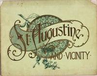
1905037517Philadelphia: J. Murray Jordan 1905. Early edition. Decorated Wrappers. Good. 24pp views from photographs. View include: City Gates; Sea Wall; Oldest House; Treasury Street; St. George Street; Charlotte Street; Hotel Ponce de Leon; The Alcazar; Fort Marion; &c. Bound in gilt-embossed green wrappers; upper corners of cover chipped. 7.75" x 9.75 J. Murray Jordan unknown
192040728Washington D.C.: Published by the United States Coast and Geodetic Survey 1920. Large folding nautical chart printed on heavy paper stock. Colored with minor wear and small loss to the top margin. A rare original coastal survey of the St Johns River and Lake George in north-central Florida bisected into two parts.<br/> <br/> Established by President Thomas Jefferson in 1807 as the Survey of the Coast the U.S. Coast and Geodetic Survey was the United States' first civilian scientific agency. This agency has followed its mission to survey the U.S. coastline create nautical charts of the coast and help increase maritime safety since its founding and has often played fascinating roles in significant chapters of U.S. history. It served in all theaters of the Civil War in the service of the Union Army and Navy pioneered acoustic exploration in the wake of the sinking of the Titanic and during WWI it worked to detect enemy submarines. In addition this agency worked to survey and produce detailed maps and renderings of the U.S. coast. These nautical survey maps commonly referred to as "T-sheets" provide fascinating insights into the history of the United States coastline which has and will continue to shift. These maps are the most important data source for understanding the physical and ecological characteristics of the U.S. shoreline. The present map is a highly detailed and accurate sea chart of the Lake George region and an important historical view of a developing Florida. Published by the United States Coast and Geodetic Survey unknown
191640686Washington D.C.: Published by the United States Coast and Geodetic Survey 1916. Nautical chart printed on heavy paper stock. Colored. A rare coastal survey of the St. Johns River near Orlando with an inset map of the river continuation in the bottom left corner.<br/> <br/> Established by President Thomas Jefferson in 1807 as the Survey of the Coast the U.S. Coast and Geodetic Survey was the United States' first civilian scientific agency. This agency has followed its mission to survey the U.S. coastline create nautical charts of the coast and help increase maritime safety since its founding and has often played fascinating roles in significant chapters of U.S. history. It served in all theaters of the Civil War in the service of the Union Army and Navy pioneered acoustic exploration in the wake of the sinking of the Titanic and during WWI it worked to detect enemy submarines. In addition this agency worked to survey and produce detailed maps and renderings of the U.S. coast. These nautical survey maps commonly referred to as "T-sheets" provide fascinating insights into the history of the United States coastline which has and will continue to shift. These maps are the most important data source for understanding the physical and ecological characteristics of the U.S. shoreline. The present map is a highly detailed and accurate sea chart of the St Johns River and an important historical view of a developing Florida. Published by the United States Coast and Geodetic Survey unknown
191640716Washington D.C.: Published by the United States Coast and Geodetic Survey 1916. Large folding nautical chart printed on heavy paper stock. Uncolored. A rare original coastal survey of the St. Johns River from Jacksonville to Fleming Island.<br/> <br/> Established by President Thomas Jefferson in 1807 as the Survey of the Coast the U.S. Coast and Geodetic Survey was the United States' first civilian scientific agency. This agency has followed its mission to survey the U.S. coastline create nautical charts of the coast and help increase maritime safety since its founding and has often played fascinating roles in significant chapters of U.S. history. It served in all theaters of the Civil War in the service of the Union Army and Navy pioneered acoustic exploration in the wake of the sinking of the Titanic and during WWI it worked to detect enemy submarines. In addition this agency worked to survey and produce detailed maps and renderings of the U.S. coast. These nautical survey maps commonly referred to as "T-sheets" provide fascinating insights into the history of the United States coastline which has and will continue to shift. These maps are the most important data source for understanding the physical and ecological characteristics of the U.S. shoreline. The present map is a highly detailed and accurate sea chart of St. Johns River around Jacksonville and an important historical view of a developing Florida. Published by the United States Coast and Geodetic Survey unknown
192140694Washington D.C.: Published by the United States Coast and Geodetic Survey 1921. Nautical chart printed on heavy paper stock. Colored. A rare coastal survey of Florida including Laguna beach Panama City Mexico Beach and Cape San Blas.<br/> <br/> Established by President Thomas Jefferson in 1807 as the Survey of the Coast the U.S. Coast and Geodetic Survey was the United States' first civilian scientific agency. This agency has followed its mission to survey the U.S. coastline create nautical charts of the coast and help increase maritime safety since its founding and has often played fascinating roles in significant chapters of U.S. history. It served in all theaters of the Civil War in the service of the Union Army and Navy pioneered acoustic exploration in the wake of the sinking of the Titanic and during WWI it worked to detect enemy submarines. In addition this agency worked to survey and produce detailed maps and renderings of the U.S. coast. These nautical survey maps commonly referred to as "T-sheets" provide fascinating insights into the history of the United States coastline which has and will continue to shift. These maps are the most important data source for understanding the physical and ecological characteristics of the U.S. shoreline. The present map is a highly detailed and accurate sea chart of BLANK and an important historical view of a developing Florida. Published by the United States Coast and Geodetic Survey unknown
1974__0729400174VOLTAIRE FOUND 1974. Paperback. New. 275 pages. 9.00x6.00x0.58 inches. VOLTAIRE FOUND paperback
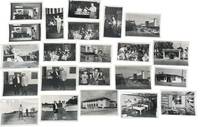
1950233201950. Clearwater Florida photo archive by George Fulmer documenting a Gulf Coast city in the early postwar Sunbelt boom: downtown storefronts automobile traffic tourism businesses beauty shops laundromats pharmacies loan offices civic buildings youth music programs local entertainments and everyday commercial life. George Fulmer identified here through the studio sleeves and the Clearwater job file context worked as a commercial and civic photographer in a period when Pinellas County grew quickly with new residents new retail construction and an increasingly car centered downtown. <br /> <br /> Photo archive of 70 items including 34 silver gelatin photographs with 36 corresponding and unique large format negatives contained in 15 studio sleeves with some annotations ranging from 3" x 5" to 4" x 5" Clearwater Florida circa early 1950s. Storefronts and signs identify Billie Moran Hair Stylist Spotlite Cleaners Launderette Family Loan Co. Loans Lane's Pharmacy Harris Drive In Pharmacy and a downtown block with the Capitol Theatre marquee and McCrory's along a traffic-filled street. Other scenes include audio equipment demonstrations musicians performing before seated audiences children handling rabbits a youth band rehearsal commercial laundry workers golfers near a clubhouse and staged presentation or prize events. Original sleeves strengthen the local identification with handwritten client names addresses dates and job numbers including "Portal Office U.S. Post Office" "P.G.A. Clinic" "Family Loan Office" "Lane Pharm" "Harris Pharmacy" and "Helpy Selfy Laundry." More scenes place people inside the social and commercial interiors of the city: a woman stands beside a microphone while another plays piano; accordion players and guitarists perform before a seated audience in a hall draped with streamers; children and an adult handle rabbits in what appears to be a club or youth program setting; a school band director leans into a room packed with young musicians and music stands; workers stand at wash stations in a commercial laundry; golfers pose and shake hands near a clubhouse; a woman and man stand on a small platform before a seated crowd during what appears to be a staged presentation or prize event.<br /> <br /> These scenes belong to the years when Florida's west coast cities were advertising modern storefronts widening their commercial appeal and absorbing the population growth that followed World War II air conditioning road building and the state's aggressive promotion of itself as a place to live shop vacation and retire. For institutional collections the group supplies named evidence of how a single city looked and conducted business during the first great Sunbelt surge: not only landmark buildings and downtown traffic but service counters display windows local entertainment children's programs and the ordinary businesses that usually vanish first from the record. Light wear minor surface handling and expected age toning to prints and negatives with some sleeves worn from studio use; overall in very good condition. A strong regional archive of Clearwater's commercial and civic life still anchored to the working paperwork that identifies who hired Fulmer and what parts of the city he was asked to record. unknown
191640706Washington D.C.: Published by the United States Coast and Geodetic Survey 1916. Large folding nautical chart printed on heavy paper stock. Colored. A rare coastal survey of Tampa Bay including Tampa St. Petersburg Clearwater Anna Maria Island and Bradenton.<br/> <br/> Established by President Thomas Jefferson in 1807 as the Survey of the Coast the U.S. Coast and Geodetic Survey was the United States' first civilian scientific agency. This agency has followed its mission to survey the U.S. coastline create nautical charts of the coast and help increase maritime safety since its founding and has often played fascinating roles in significant chapters of U.S. history. It served in all theaters of the Civil War in the service of the Union Army and Navy pioneered acoustic exploration in the wake of the sinking of the Titanic and during WWI it worked to detect enemy submarines. In addition this agency worked to survey and produce detailed maps and renderings of the U.S. coast. These nautical survey maps commonly referred to as "T-sheets" provide fascinating insights into the history of the United States coastline which has and will continue to shift. These maps are the most important data source for understanding the physical and ecological characteristics of the U.S. shoreline. The present map is a highly detailed and accurate sea chart of Tampa Bay and an important historical view of a developing Florida. Published by the United States Coast and Geodetic Survey unknown
191540709Washington D.C.: Published by the United States Coast and Geodetic Survey 1915. Large folding nautical chart printed on heavy paper stock. Colored. Coastal survey map encompassing Tampa Bay up to Cape San Blas including St. Petersburg Tampa Clearwater St. George Island and Cedar Keys.<br/> <br/> Established by President Thomas Jefferson in 1807 as the Survey of the Coast the U.S. Coast and Geodetic Survey was the United States' first civilian scientific agency. This agency has followed its mission to survey the U.S. coastline create nautical charts of the coast and help increase maritime safety since its founding and has often played fascinating roles in significant chapters of U.S. history. It served in all theaters of the Civil War in the service of the Union Army and Navy pioneered acoustic exploration in the wake of the sinking of the Titanic and during WWI it worked to detect enemy submarines. In addition this agency worked to survey and produce detailed maps and renderings of the U.S. coast. These nautical survey maps commonly referred to as "T-sheets" provide fascinating insights into the history of the United States coastline which has and will continue to shift. These maps are the most important data source for understanding the physical and ecological characteristics of the U.S. shoreline. The present map is a highly detailed and accurate sea chart of the coast of Florida from Tampa Bay to Cape San Blas and is an important historical view of the developing state. Published by the United States Coast and Geodetic Survey unknown
2000mon0000694754R&L Education 10/4/2012 12:00:01 A. hardcover. Like New. 0.7000 in x 9.1000 in x 6.4000 in. R&L Education hardcover
196959289St. Petersburg Florida: Museum of Fine Arts. As New. 1969. Paperback. FREE UPGRADE to Courier/Priority Shipping Upon Request IN STOCK AND IMMEDIATELY AVAILABLE FOR SHIPMENT - AS NEW THE TEXT BLOCK IS PRISTINE CLEAN UNMARKED AND IN EXCELLENT CONDITION - - 48 pp. With 27 ills. 2 col. . 23 x 27 cm. -- with a bonus offer-- . Museum of Fine Arts paperback
199046424New York: BasicBooks. Near Fine in Near Fine dust jacket. 1990. First Edition; First Printing. 1/4 Cloth. 046500749X . A bright first edition/first printing in Near Fine condition in alike dust-jacket with trivial edgewear; This book is about the illusion of control and how it can lead to unhappiness and dissatisfaction in our lives. The authors explain how we often take for granted the things we have control over like our jobs our relationships and our health. But when we lose control over these things we can become unhappy. The authors offer advice on how to break through the illusion of control and find happiness and satisfaction in our lives.; 8vo; 262 pages . BasicBooks hardcover
1992Q-0465007600Basic Books 1992-03-18. Paperback. New. New. In shrink wrap. Looks like an interesting title! Basic Books paperback
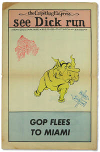
197254577Miami: Florida People's Coalition 1972. Hardcover. Very good. Hardcover. 16. Newsprint paper in tabloid format. Pages tanned as usual with horizontal fold to the middle else very good. Three color "Confront the GOP Convention" centerfod. Possible one shot published to bring attention and funds for the Florida People's Coalition. <br/><br/> [Florida People's Coalition] hardcover
19991318063PN. New. 1999. Soft Cover. Date is original print. This is a reprint edition . PN paperback
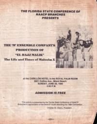
1980List3013Miami Florida: Allied Printing 1980. Single sheet measuring 8 ½ x 11 inches. Worn with some folding at corners; very good plus. A flyer for a production of Louisiana playwright professor and journalist Norbert Davidson Jr.’s “El Hajj Malikâ€: The Life and Times of Malcom X. This production sponsored by the Florida State Conference of NAACP Branches was put on by the ‘M’ Ensemble Company. Established in 1971 and still operational as of 2025 the ‘M’ Ensemble is Florida’s longest-running African American theater company. Davidson’s El Hajj Malik was written when he was a college student at Dillard University in the 1960s and was widely performed nationally and internationally according to his obituary in the Louisiana Weekly.1<br /> <br /> 1 Ryan Whirty “Playwright professor and former editor of The Louisiana Weekly dies†The Louisiana Weekly May 6 2019. Allied Printing unknown
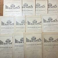
192934381Jacksonville: State Board of Health 1929. Periodical. Good. Incomplete run of 27 periodicals titled the Florida Health Notes. Issues are mostly in good condition with some minor edge tears toning and light foxing. A front cover of one issue is detached. Articles cover malaria and mosquitos rabies fatal automobile accidents vaccine population data mortality marriages and divorces and several other subjects. State Board of Health unknown
1959ZB705266Florida Association of Architects / Roger W. Sherman 1959. Volumes 9 through 26 1959-1976 lacking volume 11#11; 12#12; Bound in buckram with original covers included except for the issues for volume 11 & 12 which are unbound in original wrappers. Ex library text clean & bindings tight. - If you are reading this this item is actually physically in our stock and ready for shipment once ordered. We are not bookjackers. Buyer is responsible for any additional duties taxes or fees required by recipient's country. Photos available upon request. Florida Association of Architects / Roger W. Sherman hardcover