403 résultats
199026722Tallahassee FL: Florida State University Gallery & Museum. New. 1990. Paperback. FREE UPGRADE to Courier/Priority Shipping Upon Request - IN STOCK AND IMMEDIATELY AVAILABLE FOR SHIPMENT - -- with a bonus offer-- . Florida State University Gallery & Museum paperback
199026721Tallahassee FL: Gallery & Museum School of Visual Arts & Dance Florida State University. New. 1990. Paperback. FREE UPGRADE to Courier/Priority Shipping Upon Request - IN STOCK AND IMMEDIATELY AVAILABLE FOR SHIPMENT - FLAWLESS COPY BRAND NEW PRISTINE NEVER OPENED -- with a bonus offer-- . Gallery & Museum School of Visual Arts & Dance, Florida State University paperback
1949313357Gainesville Fla 1949. Aprox 77 pen and ink drawings with the newspaper cliping done generally for Wednesdays and Sundays. 8vo & 4to. In spiral rink notebook. Aprox 77 pen and ink drawings with the newspaper cliping done generally for Wednesdays and Sundays. 8vo & 4to. unknown books
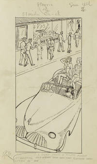
1949313357Gainesville Fla 1949. Aprox 77 pen and ink drawings with the newspaper cliping done generally for Wednesdays and Sundays. 8vo & 4to. In spiral rink notebook. Aprox 77 pen and ink drawings with the newspaper cliping done generally for Wednesdays and Sundays. 8vo & 4to. unknown
19952144487Atlanta: Scholars Press 1995. X, 255, (9) Seiten. 8° (17,5-22,5 cm) Orig.-Leinenband. [Hardcover / fest gebunden].
19962144486Atlanta: Scholars Press 1996. X, 250, (14) Seiten. 8° (17,5-22,5 cm) Orig.-Leinenband. [Hardcover / fest gebunden].
192040721Washington D.C.: Published by the United States Coast and Geodetic Survey 1920. Large folding nautical chart printed on heavy paper stock. Uncolored. A rare original coastal survey of Apalachicola Bay and Cape San Blas including St. George Island.<br/> <br/> Established by President Thomas Jefferson in 1807 as the Survey of the Coast the U.S. Coast and Geodetic Survey was the United States' first civilian scientific agency. This agency has followed its mission to survey the U.S. coastline create nautical charts of the coast and help increase maritime safety since its founding and has often played fascinating roles in significant chapters of U.S. history. It served in all theaters of the Civil War in the service of the Union Army and Navy pioneered acoustic exploration in the wake of the sinking of the Titanic and during WWI it worked to detect enemy submarines. In addition this agency worked to survey and produce detailed maps and renderings of the U.S. coast. These nautical survey maps commonly referred to as "T-sheets" provide fascinating insights into the history of the United States coastline which has and will continue to shift. These maps are the most important data source for understanding the physical and ecological characteristics of the U.S. shoreline. The present map of the Florida coastline precedes the development of the town of Eastpoint and the building of the John Gorrie Memorial Bridge which connects Eastpoint with Apalachicola. The current site of Eastpoint is marked as Godleys Bluff on the present map. This map is a highly detailed and accurate sea chart of the coastal Florida and an important historical view of the developing state. Published by the United States Coast and Geodetic Survey unknown
191640717Washington D.C.: Published by the United States Coast and Geodetic Survey 1916. Large folding nautical chart printed on heavy paper stock. Uncolored. Rare original coastal survey of Florida's Apalachee bay.<br/> <br/> Established by President Thomas Jefferson in 1807 as the Survey of the Coast the U.S. Coast and Geodetic Survey was the United States' first civilian scientific agency. This agency has followed its mission to survey the U.S. coastline create nautical charts of the coast and help increase maritime safety since its founding and has often played fascinating roles in significant chapters of U.S. history. It served in all theaters of the Civil War in the service of the Union Army and Navy pioneered acoustic exploration in the wake of the sinking of the Titanic and during WWI it worked to detect enemy submarines. In addition this agency worked to survey and produce detailed maps and renderings of the U.S. coast. These nautical survey maps commonly referred to as "T-sheets" provide fascinating insights into the history of the United States coastline which has and will continue to shift. These maps are the most important data source for understanding the physical and ecological characteristics of the U.S. shoreline. The present map of the Florida coastline is notable for the inclusion of St Marks light house built at the head of the St Marks River to assist in navigation to and from the important 19th century agricultural port of St Marks. This map is a highly detailed and accurate sea chart of the Apalachee Bay from Fish Creek to Alligator Point and an important historical view of a developing Florida. Published by the United States Coast and Geodetic Survey unknown
191640680Washington D.C.: Published by the United States Coast and Geodetic Survey 1916. Large folding nautical chart printed on heavy paper stock. Colored. A rare coastal survey of Apalachee Bay including Alligator Point and St. George Island.<br/> <br/> Established by President Thomas Jefferson in 1807 as the Survey of the Coast the U.S. Coast and Geodetic Survey was the United States' first civilian scientific agency. This agency has followed its mission to survey the U.S. coastline create nautical charts of the coast and help increase maritime safety since its founding and has often played fascinating roles in significant chapters of U.S. history. It served in all theaters of the Civil War in the service of the Union Army and Navy pioneered acoustic exploration in the wake of the sinking of the Titanic and during WWI it worked to detect enemy submarines. In addition this agency worked to survey and produce detailed maps and renderings of the U.S. coast. These nautical survey maps commonly referred to as "T-sheets" provide fascinating insights into the history of the United States coastline which has and will continue to shift. These maps are the most important data source for understanding the physical and ecological characteristics of the U.S. shoreline. The present map is a highly detailed and accurate sea chart of the Apalachee Bay and an important historical view of a developing Florida. Published by the United States Coast and Geodetic Survey unknown
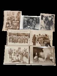
1972234431972. Florida antiwar protest press archive documenting demonstrations in Miami Beach during the 1972 Republican National Convention when activists targeted President Richard Nixon's renomination after years of bombing troop deployments and stalled peace negotiations in Vietnam. Protesters gathered outside convention sites government buildings and public streets to oppose the war challenge Nixon's reelection campaign and confront the heavy police and military security presence surrounding the convention.<br /> <br /> Photo archive of 7 Large silver gelatin press photographs each approx 8 x 10" Miami Beach Florida 1972. Military police march toward convention stations carrying riot clubs and wearing helmets and flak suits; demonstrators are pushed back by uniformed personnel; a seated protester is restrained on the grass by police; and tear gas fills a street as a demonstrator crouches near a smoking canister. Additional scenes show antiwar organizers seated indoors with signs reading "Stop the War Now" helmeted police standing over demonstrators in the street and a protester being taken away during a confrontation. Captions identify Miami Beach the Republican National Convention police preparations arrests and disruption threats tied to convention proceedings.<br /> <br /> The archive records the 1972 convention as a flashpoint in the late Vietnam War when Nixon campaigned on strength abroad while antiwar activists challenged the bombing of North Vietnam the mining of Haiphong Harbor and the continuation of U.S. military policy despite troop withdrawals. Miami Beach became a controlled political theater where nomination ceremonies unfolded behind lines of police National Guard and military personnel while demonstrators used sit-ins marches and street actions to force the war into public view. Press stamps caption slips editorial envelopes and agency markings preserve the photographs as working news files from the confrontation. Light handling wear caption attachments editorial markings toning and minor edge wear. Overall in good condition. unknown
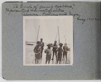
19012885Various locations in Florida 1901. About very good. 16 leaves illustrated with thirty-two original vernacular photographs all 3.5 x 3.5 inches most with manuscript captions in ink above the images. Oblong octavo. Contemporary gray paper wrappers white titles on front cover. Spine mostly split a few shallow chips to edges. Internally clean. A small but important vernacular photograph album containing rare views of the devastation wrought by the Great Fire of 1901 in Jacksonville Florida which took place on May 3 1901. The most destructive event in the history of Jacksonville the Great Fire swept through 146 city blocks destroying over 2000 buildings killing seven people and leaving almost 10000 residents without homes. It is considered the third-largest urban fire in United States history after the Great Chicago Fire and the 1906 San Francisco conflagration.<br /> <br /> The photographs in the present album were taken by an unidentified passenger aboard the Clyde Line steamer Comanche. Eight of the images capture the scene in devastated Jacksonville including a shot of the ruins of the Windsor and St. James hotels shots from atop the "Jacksonville Government Building" a group picture of the city guard "ruins of Jacksonville Court House" "An unknown ruin" a crowded scene at the Jacksonville wharf and a distant shot showing "Ruins of Jacksonville taken from Steamer Comanche May 12." All of the photographs of Jacksonville are dated in manuscript on May 12 1901 nine days after the Great Fire.<br /> <br /> In addition to the Jacksonville pictures other identified locations along the photographer's voyage include the Hillsborough River near Tampa the Tampa Court House scenes around the Tampa Bay Hotel family pictures in Florida the Comanche and its crew Fort Sumter and four views around Charleston. One particularly notable photograph shows six boys standing in shallow water holding fishing nets likely near Tampa. The image is captioned "A group of young crabbers representing three nationalities American Italian and Negro May 10 1901. unknown
19831119268Fort Lauderdale FL: Museum of Art Fort Lauderdale Florida. Good paper copy ex. cat. 68 no. pp 1 pp intro 2 pp preface 1 pp ack 8 4/C illus the remainder are B/W. limited to 2000 copies . Good. Paper. 1983. Museum of Art, Fort Lauderdale, Florida unknown
1983029454Fort Lauderdale FL: Museum Of Art. Paperback. 1983. Oblong 4to 68pp . Very Good with no DJ. 68 pp. B&W and Color Illustrations. Front cover has light soiling and some fading along bottom edge. This is an large oblong paperback art exhibition catalog from the Museum of Art Fort Lauderdale Florida January 12 to February 28 1983. John H. Surovek Guest Curator . Museum Of Art paperback
192053711Fort Pierce FL: n.p. 1920-1931. Oblong 4to. 12.25 x 7.5 in. 24 silver gelatin linen-backed photographs dated & negative number in lower margin of image each mounted on linen hinge sized 6.75 x 10.25 in. Contemporary limp pebbled leather post-binder yapp edges nickel-plated screw posts at gutter margin rounded corners wear rubbing w/o spine wear & minor loss to couple corners still a G exemplar with photos in excellent condition. This remarkable promotional photo album provides a series of photographs documenting the impact of the explosion of development interest in Florida during the Roaring 20s by offering a visual record over 11 years of the building and opening of the Port of Fort Pierce. The album opens with an image dated May 8 1921 showing the last 100 yards to be cut for the a 100 foot wide and 4 foot deep channel the Tuscawilla dredge finishing the last portions of the cut and finally the opening of the Fort Pierce Inlet to the sea which would scour the channel to a depth of 12 feet. A photo dated April 10 1924 shows the operation to dredge the inlet down to 25 feet in order to allow freighters and steamships to enter the Port. Due to erosion local interest began construction of another jetty in 1926 which is shown with railroad tracks stretching to the sea in December 1927 followed by images of the historic dredger the Corozal which had worked on digging the Panama Canal and was capable of dredging to a depth of 50 feet. Finally in Nov. 1929 the Port opened for business with the 4-masted lumber schooner Catherine Scott picking up a load of lumber for delivery to Cuba Feb. 5 1930 followed by the 2339 gross ton SS Betty Weems a Baltimore & Carolina Steamship Company freighter arriving amidst inaugural celebrations of the use of the Fort Pierce Port and opening. There are an addition number of photos up to July 1931 showing such ships as the oil tanker SS Herbert G. Wylie the SS Lillian a freighter owned and operated by A.H. Bull & Co. of New York and a number of other Baltimore & Carolina Steamships. Although the Port had been finished and opened by the end of 1929 the Great Depression and land bust in Florida resulted in such land developments as Indrio and San Lucie never being completed and the area would eventually prove successful as a Naval Amphibious Training Base during World War II with over 140000 troops trained and processed during the War. n.p., hardcover
195589980Allen Lane and Scott 1955. Hardcover. Used - Very Good. Allen Lane and Scott Philadelphia 1955. x 164 pages. Illustrated. 11.25 x 9.25" hardcover no dj. No dj clean tight VG/none. Allen, Lane and Scott hardcover
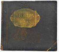
1934299721St. Augustine FL: The Record Company 1934. Southern Art Engraving Company and Dixie Engraving. Where art and nature join their crafts in a kingdom by southern seas."~~10 1/2†x 11 1/2†stiff soft-cover album with brown leatherette cover gilt title plaque and embossed palm tree and other designs. ~~Each page has a large photograph of stately homes throughout the state framed in an art deco-style device and captioned with the owner’s name and location. Mostly black and white with some color. With a foreward preface and afterward by the Dept of Agriculture. Includes homes of Ford Rockefeller Edison DuPont and other prominent figures of the time. ~~125pp. Slight wear to cover a few photographs with minor moisture damage from facing page; foxing on interleaving paper encroaching into edges of first several leaves. Otherwise very good. Quite scarce. The Record Company unknown
198513741985. Softcover. VG but sheets are loose because the binding glue has dried. Wraps. 80 pp. 6 color 27 bw repros. Introduction by Roy C. Craven Jr. Thirty-three works are listed and annotated and another ten paintings are listed on the last page. unknown books
1979Alibris.0036746Mindano State University. 1979. Trade paperback. Very good. 127 p. Includes: maps bibliography. Mindano State University paperback
1970F0036München, Kölbl, 1970. zahlreiche, Abbildungen im Text und auf (teils gefalteten) Tafeln, ca. 800 S., 5 Theile in 1 Band. Reprint d. 2. Auflage. OKunstleder. Zustand -2, Schnitt stockfleckig, Ecken etwas gestaucht.
193293966NY:: Samuel French. Very Good. 1932. Paperback. This copy is from the personal library of the late Madeleine L'Engle 1963 Newbery Award winner for her now classic young adult fantasy novel A WRINKLE IN TIME and bears her handwritten name and New York City address on the half-title page. First edition thus paperback. Age darkened along the spine moderate edge wear else very good in printed wraps. ; 137 pages . Samuel French, paperback books
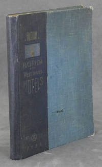
19380086079Miami Beach FL: Davis and Campbell 1938. Hardcover. Very Good. 1938. Hardcover folio spiral-bound in cloth-backed boards. 196 pp. profusely illustrated with b&w photos. Very Good. Rubbing and light soil to the boards; corners worn; faint dampstain to upper corner of the first 10 pages only; otherwise clean and unmarked. A rare book -- OCLC locates only 10 copies. A showcase of the area at its peak includes The Hollywood Beach Hotel Stetson University the Gulfstream Apartments Whitman Kenmore Hotel El Comodoro Miramar as well as sections on Cuba Key West Palm Beach Tampa Winter Haven and many many more. Davis and Campbell hardcover
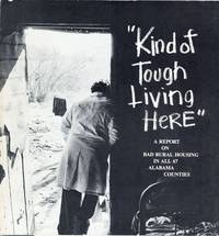
197628116Philadelphia: American Friends Service Committee 1976. First Edition. Square quarto 22.75cm.; original photo-illustrated card wrappers; 100pp.; photographic illus. throughout. Wear from handling especially at spine foot; toning and light dampstaining to spine edge of upper wrapper; About Very Good. Showcasing the worst housing available in each Alabama county including shacks located on the property of John D. Garrett state director of the Farmers Home Association. American Friends Service Committee unknown books
192264060Tallahassee FL & Buffalo & New York NY: Department of Agriculture Florida The Matthews-Northrup Works 1922. One large oblong double-atlas folio colour lithograph map sized 50 x 44 in. county lines and railroad lines demarcated in colours fold creases as issued minor dustsoiling edgewear to verso some very slight weakening to a couple fold creases otherwise a VG bright copy. First edition thus of this uncommon and updated sectional map of Florida incorporating the 1920 census numbers as well as updating the agricultural statistics farm properties and average acreage values at the outset of the Roaring 20’s. Also delineated are the railroads reaching into Florida including the Atlantic Coast Line Florida East Coast RR Seaboard Air Lines Georgia Southern & FLorida RR Louisville 7 Nashville RR and others. McRae 1870-1943 headed the Florida Department of Agriculture from 1912-1923. Worldcat locates 2 physical copies U of FL WI Hist. Soc. Department of Agriculture, Florida, The Matthews-Northrup Works, unknown
199248614Newe York, Western Publishing Company, Inc. Racine, Wisconsin, 1992. 80 Seiten , 15 cm, kartoniert
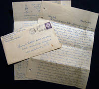
195623527Pensacola Florida: Not Published 1956. 4 pages written in ink in a good legible hand; G.C. Pierzchanowski in Special Services at Corry Field writing friend George Tuthill stationed at NAS Lakehurst NJ; missing his friend he requests more letters; commiserates with Tuthill concerning relationship entanglements and confusions discussed; evidently there has been competition and break-offs among several inter-related people with some violence: ".I'm glad that Shirley finally got sense enough to break off with John. He's no dam good to her going around slapping her and telling her off all the time. John deserves what he's got now "nothing"."; and relating some of his own story ".I'm playing football here on the varsity team for Pensacola and so I haven't had much time to see this girl here in town who I've been going with for quite a while."; and going on to graphically describing a sexual incident; he tells of 'dumping' this woman and pines for another back home; drinking is a large part the friends' activity and he has some 4 incarcerations with the Shore Patrol ".and a fifth time won't hurt any."; looking forward to Christmas visiting and getting drunk together and perhaps re-uniting with a former lover; on lined 8" x 10 1/2" notepaper with the original mailing envelope 3c stamp canceled Pensacola Nov. 5 1956; envelope with opening at side edge torn away; old fold lines to notepaper in very good condition; a small and lively bit of evidence of the life of this U.S. Navy serviceman. Manuscript. Not Bound. Very Good. Not Published Paperback books