(Boston Chronicle)Biblio.com
57 résultats
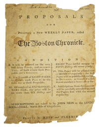
1767313300Boston: Printed by Mein and Fleeming 1767. 2 pp. prospectus printed recto and verso of a single sheet. 4to 10-1/2 x 8 inches. Damage at edges with loss to text month October missing from heading lower corner torn away with loss to"G" in Fleeming in imprint a few letters lost from right margin on recto and 12 lines affected on verso toned and stained. Signed "Mich. Franklin 1768" at top of recto. 2 pp. prospectus printed recto and verso of a single sheet. 4to 10-1/2 x 8 inches. Rare early American newspaper prospectus announcing publication of The Boston Chronicle a weekly Loyalist paper. "John Mein a bookseller was the publisher and John Fleeming the printer. With the beginning of the second year the size of the paper was enlarged to folio and it was publihsed every Monday and Thursday and was the first newspaper to be published twice a week in New-England. To avoid popular resentment of his political views Mein was forced to leave the country before the close of its second year and the paper was continued by Fleeming in the name of the firm until its publication ceased on the 25th of June 1770" Evans.<br /> <br /> The five "conditions" listed on the recto detail the general design of the paper - that it will be printed on high quality demy paper with specially designed type 8 pages in quarto priced at 6 shillings and 8 pence printed every Monday and delivered to subscrribers with care. The verso with text in three columns outlines a plan of the contents of the paper including coverage of current events and issues essays on moral subjects notices on newly published books poetry etc. Ford Broadsides 1418; Shipton-Mooney 41736; Bristol B2787 recording 4 copie; Evans 10565 for newspaper Printed by Mein and Fleemin[g] unknown
1767313300Boston: Printed by Mein and Fleeming 1767. 2 pp. prospectus printed recto and verso of a single sheet. 4to 10-1/2 x 8 inches. Damage at edges with loss to text month October missing from heading lower corner torn away with loss to"G" in Fleeming in imprint a few letters lost from right margin on recto and 12 lines affected on verso toned and stained. Signed "Mich. Franklin 1768" at top of recto. 2 pp. prospectus printed recto and verso of a single sheet. 4to 10-1/2 x 8 inches. Early American newspaper prospectus. Rare early American newspaper prospectus announcing publication of The Boston Chronicle a weekly Loyalist paper. "John Mein a bookseller was the publisher and John Fleeming the printer. With the beginning of the second year the size of the paper was enlarged to folio and it was publihsed every Monday and Thursday and was the first newspaper to be published twice a week in New-England. To avoid popular resentment of his political views Mein was forced to leave the country before the close of its second year and the paper was continued by Fleeming in the name of the firm until its publication ceased on the 25th of June 1770" Evans.<br/><br/>The five "conditions" listed on the recto detail the general design of the paper - that it will be printed on high quality demy paper with specially designed type 8 pages in quarto priced at 6 shillings and 8 pence printed every Monday and delivered to subscrribers with care. The verso with text in three columns outlines a plan of the contents of the paper including coverage of current events and issues essays on moral subjects notices on newly published books poetry etc. Ford Broadsides 1418; Shipton-Mooney 41736; Bristol B2787 recording 4 copie; Evans 10565 for newspaper Printed by Mein and Fleemin[g] unknown books
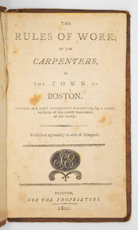
1800100845Boston: Printed for the proprietors by Samuel Etheridge 1800. 8vo. 34 pp. Contemporary sheep; upper board detached ffep removed in a custom chemise and slipcase. Scarce American price book for Boston carpenters in contemporary sheep. Signed as usual by Thomas Stutson secretary of the committee that drew up the rules which were devised to establish a fair system of charges for services rendered. Prices are an early example of the use of dollars and cents. Rink lists previous editions from 1774 1 copy 1794 no copy known & 1795 2 copies.PROVENANCE: William Reese book-label on chemiseREFERENCE: Evans 37003; Rink 1760 Printed for the proprietors [by Samuel Etheridge] unknown
17793689<b>Scarce Contemporary Stony Point Battle Plan</b><br /><br />This rather crude woodcut depicts a battle plan of General "Mad Anthony" Wayne's daring and dramatic capture of the British fortification at Stony Point about 30 miles up the Hudson River from New York City. The battle planned in detail by Washington took place around midnight on July 16 1779. <br /><br /> The lower portion of the battle plan includes a four item key: "A. The British Fortress B. Abattes abatis in front C. The Reserve D. The detached Party who stormed the Works." Nebenzahl's <i>A Bibliography of Printed Battle Plans of the American Revolution 1775-1795</i> cites only a 1784 London-printed battle plan by Faden for the Stony Point engagement #145. The offered plan is not noted by Nebenzahl was published in America and was issued five years earlier than the Faden plan. The<i> Bickerstaff's Boston Almanack</i> for 1780 would almost certainly have been published in November or December of 1779 – within six months of the actual battle. <br /><br /> A very scarce almanac in the trade. Auction records indicate the most recent copy sold at the Gutman sale in 2005 for $4800. Prior to that Swann sold an example in 1979. <br /><br /><b>References:</b> For the almanac: Evans: 16287; Drake: 3290. For the map: Cresswell: 309. <br /><br /><b>Condition: </b>Map appears on verso of title page and measures about 6 ½ x 3 ¾." Almanac is complete in 24 pp. Slight loss of road table text at upper tip of final leaf.<br /><br />ICN 7643. Printed and sold by Draper and Folsom, and John Mycall of Newbury.
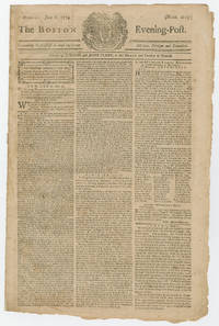
177424806<p>Early report in the local Boston newspaper on implementation of Parliament's Boston Port Act the first of the Intolerable Acts and the reaction to it in Massachusetts and beyond. Taking effect on June 1 1774 rather than punishing individuals the Act besieged the entire city until the colonists paid for the tea destroyed in the Tea Party December 16 1773.</p><p>"<i>the Act of Parliament for blocking up the Port of Boston is now in all its Parts carrying into Execution with the greatest Severity many Vessels being already prevented from coming in and Fishing boats and other small Craft strictly search'd; so that we have reason to expect that in a little time this Town will be in a truly distressed and melancholy Situation.</i>" p3/c1</p> <b>BOSTON PORT ACT.</b>Newspaper. <i>The Boston Evening-Post</i> June 6 1774 No. 2019. Boston: Thomas and John Fleet. 4 pp. 9¾ x 15⅜ in.<p><br /></p><p>The majority of this paper is devoted to patriotic content. The front page features a series of Questions and Answers from New York "<i>being conceived in some measure calculated to advance the cause of freedom in the present critical situation of affairs.</i>" It goes on to note that "<i>A Congress of Deputies from the several Colonies is thought to be absolutely necessary to devise means of restoring harmony between Great Britain and the Colonies and prevent matters from com</i>ing <i>to extremities</i>" p1/c1-2.</p><p>"<i>A Friend to Mankind</i>" wrote to the publishers "<i>When I first read the barbarous Act for shutting up the port of Boston; an act made with the pious design to starve the poor; make the industrious idle; the happy miserable; and as an entering wedge to the horrid purpose of enslaving America although I was transported beyond measure I could not help reflecting that bitter as it was for the present it would absolutely be of happy tendency to America in the result.</i>" p2/c1.</p><p>This issue prints a May 25 address from 33 Marblehead loyalists congratulating Massachusetts Gov. Thomas Hutchinson on his administration and wishing him a safe return trip to Great Britain p1/c3. On the other hand a public meeting in Marblehead denounced the address and declared Hutchinson "<i>an inveterate Enemy to the Liberties of the Province</i>" p2/c3.</p><p>This issue also announces from Boston "<i>the Corporation of <b>Harvard College</b>have voted that considering the present dark Aspect of our public Affairs—There be no public Commencement this Year—and that the Candidates for the first and second Degrees shall receive their Degrees in a general Diploma</i>" p3/c1. On May 1 1775 less than two weeks after the Battles of Lexington and Concord the faculty of Harvard dismissed the undergraduates early for the summer vacation again without a public commencement. Classes did not resume until October in Concord twenty miles away where students boarded with local residents and college courses were held in a deserted grammar school the courthouse and the First Parish meetinghouse. Meanwhile the five buildings of the college's campus in Cambridge housed 1600 American soldiers. After the British surrendered Boston in March 1776 and the American troops moved south to defend New York the college was permitted to reoccupy its buildings in June. Of 190 freshmen entering between 1775 and 1778 only 30 left prior to graduation.</p><p>An advertisement is included for a just-published pamphlet <i>Observations on the Act of Parliament commonly called the Boston Port Bill with Thoughts on Civil Society and Standing Armies</i>p2/c1. From September 1774 to March 1775 Josiah Quincy II 1744-1775 was in England arguing the American cause to sympathetic British politicians. He died of tuberculosis on the return voyage within sight of Massachusetts.</p><p><b>Historic Background</b></p><p>Relief for Boston was sent from as far away as South Carolina and the First Continental Congress convened in Philadelphia three months later to coordinate a colonial response to the Intolerable Acts.</p><p>Parliament finally repealed the Boston Port Act in 1783 after fighting ceased in the American Revolutionary War but before the Treaty of Paris officially ended the war and recognized American independence.</p><p><b>Condition</b></p><p>Near fine; several professional mends to gutter margin. A bright and attractive issue of an important colonial newspaper.</p> Thomas and John Fleet books
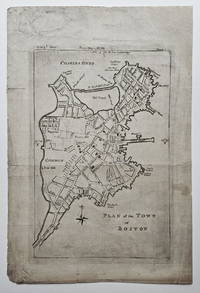
17843834<p>This extremely scarce map of Boston appeared as part of the <em>Geographical Gazetteer of the Towns in the Commonwealth of Massachusetts</em> a work issued in parts as a supplement to <em>The Boston Magazine</em> from October 1784 through December 1785. The map appeared with the October 1784 issue of <em>The Boston Magazine</em>.</p><p>Wheat & Brun note that this map is based largely on Norman's <strong>Plan of the Town of Boston with the Attack on Bunkers-Hill.</strong> published in the Boston edition of <em>An Impartial History of the War in America</em> in 1781. The present map covers a somewhat smaller geographic area and on a modestly larger scale than the map that appeared in <em>An Impartial History</em>. It also adds/eliminates/changes some street names and landmarks making it more than a direct re-engraving and suggesting the involvement of a cartographer -- perhaps Osgood Carleton with whom Norman collaborated on several maps and charts in the late 18th and early 19th centuries. Norman's 1781 <strong>Plan</strong> was itself sourced directly from the map appearing in the English edition of <em>An Impartial History </em>1778.</p><p>Although the present map is not listed in the Boston Engineering Department's <em>List of Maps of Boston Published Subsequent to 1600</em> 1904 it is referenced in the listing for a 1789 version of the map that had apparently been re-engraved for Norman's <em>Boston Directory</em> 1789. Very scarce. No examples listed for sale in the <em>Antique Map Price Record </em>1983-2011 and we not aware of any other examples being offered in the past twenty years.</p><p>A lovely example of one of the most uncommon 18th century maps of Boston.</p><p><strong>References:</strong> Wheat & Brun <em>Maps and Charts Published in America before 1800</em>: 242. Jolly<em> Maps of America in Periodicals before 1800</em>: 402. Lewis: <em>A Guide to Engravings in American Magazines 1741-1810</em>: p. 3. Stauffer <em>American Engravers Upon Copper and Steel</em>: 2361.</p><p><strong>Condition: </strong>A strong image. Soiling and some darkening to plate area apparently as printed. Blank area of upper right corner skillfully replaced and three short fold separations repaired on the reverse.</p><p>ICN 7760.</p> [Greenleaf and Freeman].
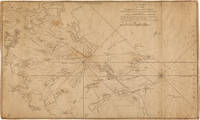
1800WRCAM52103London: R. Laurie and J. Whittle 1800. Engraved map sheet size approximately 21 x 34 3/4 inches. Backed with linen. Mid-19th-century ownership inscription near title. A few small chips and minor closed tears at edges light soiling and scattered faint foxing. Very good. Framed. An extremely scarce nautical chart of Boston Harbor from the second edition of the important 18th-century American atlas the NORTH AMERICAN PILOT. The chart depicts the state of the harbor just after the start of the Revolution having been reprinted from the first edition published in 1776 and 1777. The Boston peninsula and the "Ruins of Charlestown" are located in the west / far left of the chart area which follows the mainland coast as far south as Dorchester and Milton and out to Point Shirley and the Shirley Cut to the northeast in the upper center of the image; the Hull peninsula and Point Allerton are also visible in the lower right-hand quadrant of the map. In the center of the chart are the numerous islands that dot Boston Harbor as well as depth measurements and clearly marked shallow areas such as the shoals formerly known as the Dorchester Flats now a populated area of reclaimed land. Additionally there are a number of guidelines showing the best routes through the harbour to various points and markings for various points on land to aid in navigation. <br> <br> The second edition of the PILOT contained seven more maps than the first for a total of seventeen charts of which this plan of Boston Harbor was the seventh. The first edition was published by Robert Sayer and John Bennett who were succeeded by Laurie and Whittle before the publication of this atlas. The original chart engravings were executed by Thomas Jefferys. Rare in any form or edition OCLC traces only one copy of this individual map from the 1800 printing located at the State Library of Massachusetts. OCLC 843954569. PHILLIPS ATLASES 1220 ref. HOWES J84 ref. SABIN 55557 ref. R. Laurie and J. Whittle unknown books