5 209 résultats
200763615Coeur d’Alene ID: Museum of North Idaho 2007. Oblong 4to. 548 pp. Photo illustrations and maps throughout. Black publisher’s cloth silver lettering front cover & spine w/ d.j. NF/NF copy. First edition of this surprisingly uncommon and well-illustrated work detailing the “engineering techniques bold innovations such as electrification much brand-new equipment and a proactive marketing department.†Rockefeller Henry Rogers and Standard Oil made the decision in 1905 to build West from Mobridge SD to Seattle & Tacoma WA building the final transcontinental railroad in the United States considered the last final burst of the Gilded Age whose efforts forever changed Montana Wyoming Idaho and Washington. Museum of North Idaho, hardcover
191550814Paris: PLM 1915. 8vo. 11 1 pp. 8 blue-tinted photo plates 1 large folding colour map at rear. Printed softcovers yapp edges minor shelfwear slight creasing still VG copy. First edition of this scarce tourism brochure handed out at the French Pavilion at the Panama-Pacific International Exposition in San Francisco. The company before World War I was urging Edwardian travelers to travel on the P.L.M. through Dijon Lyons Saint-Etienee Le Creusot Marseille Vichy Evian Aix-les-Bains and more. In addition travelers could visit Vienna Orange Avignon Arles Nimes Savoy and many other places. PLM, paperback
195956407Mexico City & Los Angeles CA: Ferrocarriles Nacionales de Mexico 1959. 4to. 10 pp unpaginated. 1 TLS on letterhead 1 mimeographed timetable for Nogales a Guadalajara 3 printed time tables for Linea de Mexico a Guadalajara w/ minor folds creases still VG. Scarce Typed Letter Signed and time tables for traveling in Mexico in 1959 from Nogales down to Ayutla Guatemala. Ferrocarriles Nacionales de Mexico, unknown
197256225Modesto CA: Guy L. Dunscomb 1972. 4to. 496 pp. Illust. title in green & black with 800 photos & text illustrations throughout 2 colour plates 18 division maps. Green embossed publisher’s boards scotch tape ghosting at fore-edges from old brodart edgewear minor chipping w/ d.j. cover art of the progression of Steam Locomotives edgewear creasing some rubbing G/G copy signed by the author on the title. Second edition 2nd printing signed of this exceptional reference work detailing the steam locomotives and the Southern Pacific railroads extending from the Pacific Ocean to the Great Salt Lake sprawling over eight states and Mexico. Guy L. Dunscomb, hardcover
18661008228vo pamphlet original printed wrappers 20 pp. Wrappers with some tears and chips at the extremities a 1x3 piece missing from top of front wrapper notation on front wrapper front wrapper and title page partially detached small tear in the middle that runs through not affecting text or particularly visible middle crease number and library stamp on title page some minor soiling normal aging; still a good or better copy. The Philadelphia and Reading represents one of the nation's oldest railroads with its roots going back to 1832. The Atlantic and Great Western is a railroad that would merge and morph several times and become the New York Pennsylvania and Ohio Railroad. The present agreement is actually between several railroad companies and the goal appears to be to share rail and transport to Philadelphia. H.G.Leisenring's Steam Printing House,
1880102313<p> Folding time table and schedule unfolded 7" x 25 1/2" folded 3 1/2" x 7" reverse side shows map of route. Some splits at folds a couple of chips and folds at corners some browning aging and occasional soiling or staining; otherwise about very good. Somewhat scarce railroad time table OCLC locates one copy that provides time table information for trips from Chicago to San Francisco. Includes a map of the routes and stops made along with railroad announcements and advertisements. OCLC. </p> Spalding & La Monte,
1840100816<p>8vo pamphlet removed dbd 31 pp. Some minor foxing and aging; otherwise very good. Interesting early railroad report to shareholders that provides considerable useful historical information including railroad construction costs and description and costs of engines and pessanger cars. While the title suggests a westward theme much of the construction is along the Connecticut River. Also the schedule of distances in the report seems to focus on Massachusetts and the greater Boston area.</p> S.N. Dickinson,
18471008208vo pamphlet publishers printed wrappers 20 pp. Crease in the middle corners and extremities chipped a bit small hole in the middle of front wrapper not affecting text wrappers darkened and faded some mild foxing in the margins; otherwise very good. Somewhat typical report to shareholders but this was published a year after the railroad was founded. The company actually shows a surplus of funds and there is a very positive tone concerning future prospects and railroad construction. Interestingly the company points to problems facing other companies who had to borrow money at very high fixed interest rates to to develop their business. Sabin 60358.
1864106881<p>8vo cloth illustrated 120 pp. Missing pages 25-48 prvious owner bookplates on front pastedown and front endpaper some browning folding map has some edge creases hiinges craked but still firm new tape on spine some spine cracking; about fair. Despite missing 23 pages there is still a lot of useful early railroad content and a number of illustrations.</p> Harper Brothers,
1850106702<p>Small pocket sized guide 4"x3" original printed wrappers folding map which is glued inside front wrapper affecting part of New York map 160 pp. Very modest wear spine expertly repaired some slight aging; otherwise very good or better. Rare pocket-size mid-19th century transportation guide. The map shows New England on one side and New York City on the other. OCLC/WorldCat lists only one copy of this August 1850 issue and the University of Michigan. Excellent detail in this what appears to be a monthly publication. #</p> Geo. R. Holbrook & Co.,
1880100458<p>Large thick folio 15x10 1/2 bound in soft tan calf maroon morocco corners and spine label marbled endpapers 26 425 111 blank pp. Hinges reinforced with cloth front joint split leather chipped at spine ends and corners are a bit worn light rubbing and finger soiling to contents; else very good. Fascinating piece of railroad memorabilia that documents railroad company mergers deeds for track expansion and other contractual correspondence dated from 1839-1915 chiefly between Massachusetts and New York. Many of the transactions mention concern the Boston and Albany Railroad connecting Boston to Albany. The ledger appears to record events from the original documents. Sometimes it cites the individual who copied the document. While the the dates of documents it refers to go back to the before the mid 19th century these entries were probably done in the late 19th century or early 20th century. The ledger contains over 400 pages of hand-written contract documents most one to three pages long plus 26 pages indexing 166 contracts at the front. Nearly all with Public Notarization as well as signatures of the people involved. These are copies of the originals inked in various highly legible hands. Many of the documents are of the Boston and Albany Railroad which would become part of the New York Central Railroad system. </p>
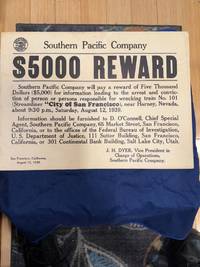
1519106700<p>Printed poster on thin card stock. 30.5x41.5 cm 12x16". Also includes a 6" x 10" flyer. Poster with vertical crease along which is an archival tape repair/reinforcement; flyer trimmed slightly bowed normal aging laid down on cloth backing. On August 12 1939 the City of San Francisco train derailed outside of Harney Nevada United States killing 24 and injuring 121 passengers and crew. While other train wrecks were deadlier this one was especially horriffic because was caused by sabotage of the tracks. Despite a manhunt reward offers including $5000 from the Southern Pacific and years of investigation by the Southern Pacific Railroad the case remains unsolved to this day. Accompanied by a handbill version of the poster.</p>
1867100112Pamphlet original printed wrappers 8vo 35 pp. with lithographic map as frontispiece. Old ink ownership signature on front cover along with small rubber stamp of library on front cover too. Library stamp on back of title page some soiling to wrappers corners nicked and a slight vertical crease. Otherwise very good. Scarce pamphlet offering a view of the building of the transcontinental railroad and some of the challenges it faced including those related to the crossing the Sierra Nevada. The map shows most of the U.S. excluding the southern fringe with the Central Pacific and Union Pacific Railroads connecting just north of Salt Lake City. The map also shows the proposed Southern Pacific Railroad from St. Louis to Southern California. The pamphlet talks about the need for the railroad because of the gold discoveries and the unlimited agricultural potential of the region. The author speculates that California could handle a population of ten million people. Also includes facts and figures about the cost of the railroad. George Brown, Printer,
19383955New York: Labor Research Association 1938 - 1962. First edition. Original Wraps. Very Good mild ex-library. Octavo some years have index some issues missing call us for more details 978-664-6455. Labor Research Association paperback
188011408Chicago: A.T. Sears & E. Webster 1880. Blue cloth decorated and titled in gilt on front cover brown end-papers. Internally clean spine sunned extremities rubbed a solid very good copy. A very nice copy of this railroad tourist guide covering from Colorado to Florida with numerous illustrations and maps. A.T. Sears & E. Webster unknown
1852102298Pamphlet 8vo folding map 17" x 34" 16 3 pp. Rear wrapper detached with some chips and tears are extremities pencil notation and ink number on top of front wrapper with a few nicks large folding map difficult to open because of the way its attached to joint but in really nice condition; otherwise good to very good. This pamphlet presents the results of a survey between Phoenixville and Pinegrove for the purpose of building a railroad. The work includes considerable financial and survey information and an excellent folding "Map of Railroad Route from Phoenixville to Pinegrove 1852." King & Baird,
18381008178vo pamphlet removed dbd 14 pp. Maybe lacking wrappers but otherwise complete number stamped on title ink number on title normal aging and foxing; otherwise very good.Scarce early railroad title that reports on the completion of a railroad between Reading and Norristown and the construction of a railroad between Norristown and Philadelphia. The report indicates that the amount of freight shipped at that point was not significant but they expected a significant increase with the completion of the next part of the railroad. Information on costs and revenues are provided as well as estimates on the cost of transporting coal to Philadelphia from the coal regions. John G. Clark,
1839100819<p>Large 8vo pamphlet half title stitched 27 pp. Half title instead of formal title page somewhat uncut dbd some tears at edges mild aging and toning; very good. This appears to be part of a House document House No. 32 dated February 27 1839 and presented by William Lincoln. The pamphlet discusses the financial challenges dating back to the late 18th century which prevented the development of transportation systems. While the title suggests a western theme much of the discussion is closer to the original colonies. The author makes a case for rail and other transportation systems by pointing out the benefits of these efforts on real and personal property values. He uses the favorable impact the Erie Canal had on property in New York. It appears that after careful consideration the House Committee voted in favor of the proposal to spend the money $1200000 on the development of the 'so called ' Western Rail-road'.</p>
1867102296Pamphlet 8vo original printed wrappers black and white folding map 13" x 16" 15 pp. Some minor soiling to wrappers abrasion in top corner of front wrapper affecting margin line a little but not affecting text map joined to page on investment offering making it a little hard to open page normal aging; otherwise very good. This pamphlet relates to a bond offering maturing in 43 years the company was issuing to raise capital. The funds would be used to complete the railroad's connecting systems. Included is typical financial data supplied with these offerings from a report by the chief engineer. Railroad bonds were a popular investment during the second half of the 19th century which helped prompt Henry Varnum Poor to publish his "History of Railroads and Canals in the United States" in 1860. This work enabled investors to see comprehensive financial information on just about all railroad companies. This pamphlet includes a very nice folding map of "The Saint Paul and Chicago Railway.". Ramaley & Hall,
199252719Portland OR: Grande Press 1992. Oblong folio. 336 pp. 100s of photos many in colour maps illusts colour map endpapers. Gray cloth gilt lettering colour map endpapers w/ d.j. minor edgewear couple small closed tears still a NF/VG- copy. First edition of Volume One of this invaluable history of the SP&S Railway which followed the Columbia River between Vancouver and Pasco up the Snake river and through Eastern Washington towards Spokane. The railroad was jointly owned by the Great Northern Railway and the Northern Pacific Railway. This volume tells the story of the main line from Portland to Spokane with a separate chapter for each segment Portland-Vancouver; Vancouver-Wishram; Wishram-Pasco; Pasco-Spokane. Of particular interest are the 3 Howard Fogg paintings. Grande Press, hardcover
1867102297Pamphlet 8vo original printed wrappers colored folding map 8 1/2" x 23 1/2" 16 pp. Some minor chips at corners and extremities pencil notation on top of the front wrapper normal aging; otherwise very good. This pamphlet relates to a bond offering the company was issuing to raise capital. Management claims that the company has favorable prospects and the mortgage bonds being offered are a secure and profitable investment. Railroad bonds were a popular investment during the second half of the 19th century which helped prompt Henry Varnum Poor to publish his "History of Railroads and Canals in the United States" in 1860. The work enabled investors to see comprehensive financial information on just about all railroad companies. This pamphlet includes typical financial data about the company and a folding "Map of the Union Pacific Railroad and its Connections." The map is in wonderful condition. Offices,
1876102314<p> Folding railroad time table unfolded 16" x 28" folded 4" x 8" illustrated with route map and engravings. Some minor chips and tears at folds and extremities some browning and aging and a little soiling; otherwise about very good. Attractive Erie Railroad time table and map. Includes large illustration of the inside of a Pullman car and two additional illustrations of a dinning car and part of Niagara Falls. The time table and schedule has considerable detail. # 102314</p>
189824215St. Louis Missouri: Woodward & Tiernan 1898. Staplebound. Very good condition. A guide book aimed at the summer tourist inclined to visit the resorts around the Great Lakes on the Wabash Railroad's expanded "Cool Northern Route" Detroit Niagara Falls and Buffalo. Starting in Detroit and ending in Quebec the book describes cities en route particular resorts and hotels: Mt. Clemens St.Clair Springs Port Huron Hotel Windermere and many more. 8 3/4 x 5 3/4" 100pp b&w ills staplebound. White illustrated card covers with a sailboat on front map of the complete line on verso. Front cover creased on one corner clean and bright. We could find no other copies. Woodward & Tiernan unknown
1904106398<p>Small 8vo soft red covers numerous illustrations from photographs; map on inside of rear wrapper 160 pp. Light wear top corner slightly bent normal aging; very good or better condition. Descriptions of the numerous locales accessible by the California Northwestern Railway running from Tiburon north to Willits with branches to Guerneville Sebastopol and a few other places. Includes interesting famility type pictures of places like Oleander's Farm Ridgewood Sonoma Creek and Greenwood Park. There is a map of California Northwestern Railway and Connections on the inside of the rear cover. The railroad was formed in 1898 and merged into the Northwestern Pacific Railway in 1907. Seems to be rather rare the OCLC/WorldCat lists only the copies at Stanford and UCLA. OCLC. </p> California Northwestern Railway,
18501008148vo pamphlet later paper wrappers two folding maps 117 2 pp. Minor foxing and browning a bit of staining in the margins mostly maps also have the staining in margins but are in great condition otherwise; overall very good. The goal of this bill in the House of Representatives was to connect the Atlantic and Pacific with a railroad. Specifically this undertaking was to construct a railroad and electric telegraph from the Mississippi to the Pacific Ocean. Whitney seems to have played a critical role in this process and started to work on the railroad project as early as 1841. The pamphlet contains a lot of information on early railroad issues especially imports and exports.