Elcesaeus, Thomas.MareMagnum

4 751 résultats
Large 12mo. 106 pp. With woodcut device on title-page. Contemporary wrappers. Arabic edition of Catholic indulgences for penitence, eucharist, and extreme unction. Some worming. OCLC 302419328.
20013720z2001. Soft Cover. Good. PB/pub.2001/Gd. condition/612 pages - An Anthology of the Terrorist attack on the World Trade Center in New York City on September 11 2001. KN43720z paperback
187 x 276 mm. With a rosette gilt and in gouache colour. Diacritical marks added later in black ink, vocalization marks in red (as well as one in green and one in blue). 5 lines. Well-preserved leaf in monumental Kufic script (line height c. 30 mm), written in dark brown ink. The text is from the middle part of verse 109 of the second Quran sura. The script style belongs to group D (according to Déroche's classification, subtype D.III). Similar examples are usually dated to the 9th century C.E. (cf. François Déroche, The Abbasid Tradition, London 1992. The Nasser D. Khalili Collection of Islamic Art, Vol. I, nos. 25 [p. 76] and 34/35 [p. 84]). The polychromatic rosette shows an inscribed number: The red dots are vocalisation marks; the diacritics (in the form of small slashes) were added later in black ink. - Some browning and staining. Brittle in places due to ink corrosion (minor defects to vellum). Verso rubbed, but still legible. Cf. Fingernagel (ÖNB 2010), p. 33.
170 x 263 mm. With gilt rosette and numerous gilt floral ornaments between the letters and in the margins. Vocalisation marks (dots) in red. 5 lines. Illuminated leaf from a once-magnificent Quran manuscript with fine gilt flower and leaf illustrations as space fillers and ornamental border around the large Kufic script written in black ink (line height ca. 25-30 mm). The ornamentation mainly consists in leaf designs with the occasional blossom. Illumination of this type is exceedingly rarely encountered among the preserved Abbasid Kufic manuscripts pre-dating the year 1000. The script style belongs to subgroup D.I, according to Déroche's classification. Manuscripts in this style are normally dated to the 9th century CE (cf. François Déroche, The Abbasid Tradition, London 1992. The Nasser D. Khalili Collection of Islamic Art, Vol. I, nos. 19-23, pp. 67-71). The red dots are vocalisation marks: diacritic marks were not used until later. - Some browning and staining. Brittle in places due to ink corrosion (slight loss to individual letters). Verso rubbed, but still legible. Cf. Fingernagel (ÖNB 2010), p. 33.
193969381Fernand Sorlot | Paris 1939 | 12 x 18.50 cm | broché
Very Good English Paperback. Roy. 8vo. (24 x 17 cm). In English. 93, [1] p. Selections for general teacher-training institutes. One of early English learning book including short stories and vocabulary printed by Egyptian government.
Large 8vo. XXII, (2), 500, (folding leaf of appendix) pp. With 27 (of 32) plates, mostly folded and coloured. Modern half calf with marbled paper boards. Red morocco label to gilt spine. First edition, very rare. The volume includes seven important historical, archaeological and geographical essays covering Baghdad, the Nahrwan canal and large parts of Kurdistan, the topography of Nineveh and the old course of the River Tigris. Also included are some 30 maps and plates, many in colour, most notably the ground-plan of Baghdad. Felix Jones first saw service on the Palinurus, surveying the northern part of the Red Sea, whilst a later commission found him engaged on the Arabian survey under Haines. In 1839 he surveyed the harbour of Graine (Kuwait) and this led to an almost continuous period of service in Mesopotamia and the Gulf, ending in 1862 as Political Agent in the Persian Gulf, in which capacity he planned the British invasion of Persia. - Lacks the large maps of the Katul es Kesrawi and River Tigris. Labels to spine chipped, spine faded, occasional blue pencil markings between pages 259 & 288, and between pages 364 & 368. Generally text and plates very clean and fresh, map at page 136 torn at fold with no loss. - No pocket is present in the rebinding nor are the 3 maps which the pocket should contain. Paper slightly browned, otherwise in good condition.
8vo. 240 pp. Red-brown cloth with title information in gilt on spine. Red upper edge. First edition of a collection of ten quite rare and otherwise inaccessible articles by the British explorer, scholar and soldier Richard Francis Burton (1821-90), compiled and edited by N. M. Penzer, the author of "An Annotated Bibliography of Sir Richard Burton" (1923). - After the publication of Burton's bibliography, Penzer received numerous requests to publish some of the articles he had mentioned but were hard to find by members of the general public. Norman Mosley Penzer (1892-1960) was a scholar who specialised in Oriental studies and a fellow of the Royal Geographical Society. He wrote several original works, for example on cotton in British West Africa (1920) or the mineral resources of Burma (1922), but he was possibly more famous for the works he edited. According to the Royal Geographical Society, Penzer was an eminent authority on Sir Richard Francis Burton but failed to write the definitive biography, though "it was well within his power to do". Apart from his works on Burton, Penzer also edited other anthropological works and even translated the tale of Nala and Damayanti from Sanskrit in 1926. - Penzer consciously made a small selection of Burton's more obscure papers, in order to give an insight into the varied activities and achievements of the explorer's life. Thus, the contents of the present work vary in subject. Burton's travels in India, Ethiopia, Gabon, Syria, and to Mecca are represented in separate articles. The subjects of other articles are more anthropological in nature, as expected regarding the title, such as the history and significance of scalping in different cultures around the world or spiritualism and religion in Africa and the Middle East. Other than the introduction, in which he explains his reasoning for including certain articles, Penzer only included short preliminary and explanatory remarks at the beginning of each paper and the occasional footnote, while Burton's work remained the focal point of the book. - Slight browning and foxing throughout, with an autograph in blue ink on the first flyleaf. Overall in good condition. Howgego IV, B98. Cf. Shapero, The Islamic World (2003), 158 (another edition).
19240008935London: A. M. Philpot Ltd. 1924. First Trade edition. Hardcover. Fine. 8vo 240 pages brown cloth untrimmed for and bottom edges. partially unopened; ex libris Thomas Barbour. <br/><br/>Penzer was of course Burton's bibliographer. He has selected ten excellent but obscure writings by Burton on Sind Mecca Harar Tanganyika and also Rome and Biovannie Battista Belzoni. A. M. Philpot Ltd. hardcover
Fine English Paperback. Pbo. Large 8vo. (22 x 22 cm). In English and Arabic. 91, [3] p., color ills. Selected Islamic inscriptions from Makkah al-Mukarramah & al-Madinah al-Munawwarah. Published on the occasion of the annual of the Executive Committee of Research Centre for Islamic History, Art and Cultural, Istanbul. 10-12 December 2002. [Exhibition catalogue].
4to. XXIII, (1 blank), 199, (1 blank) pp. With the title-page in red and black, 1 map of the Hadhramaut titled: "Seen in the Hadhramaut", and 50 double sided plates. The plates are included in the pagination. Blue cloth with black lettering on front cover and spine. With dust jacket. First edition. A perspective on the Hadhramaut region in Southern Arabia and its people through the eyes and camera lens of traveller, writer, and photographer Freya Stark (1893-1993). Of Italian and British descent, Stark was born in Paris and grew up in several places throughout Europe. Her present account tells the story of Southern Arabia in 130 photographs with corresponding descriptions. - Dust jacket is slightly soiled and very slightly damaged (mostly around head and foot of spine), binding and edges with some slight discoloration and foxing, endleaves partially browned. Blackmer 1470. Howgego IV, S 61. Smith, The Yemens, 98. Sotheby's, Burrell sale, lot 889. Cf. article "Freya Stark" in Encyclopaedia Britannica; Macro 2118 (1939 ed.); Shapero, The Islamic World (2003), 468.
Roy. 8vo., First Edition, Blue Issue, title in red and black, with numerous fine photographs (tinted in sepia) by the author throughout, some mild offsetting from fold-ins to free endpapers, near contemporary inscription on front free endpaper; blue cloth, upper board and backstrip lettered in darker blue, a very good, bright, clean copy in price-clipped dustwrapper. Virtually 'near fine' copy of the author's fourth book. This copy is an unspecified later issue of the first edition, bound in blue rather than oatmeal cloth. VERY SCARCE, ESPECIALLY IN THIS CONDITION.
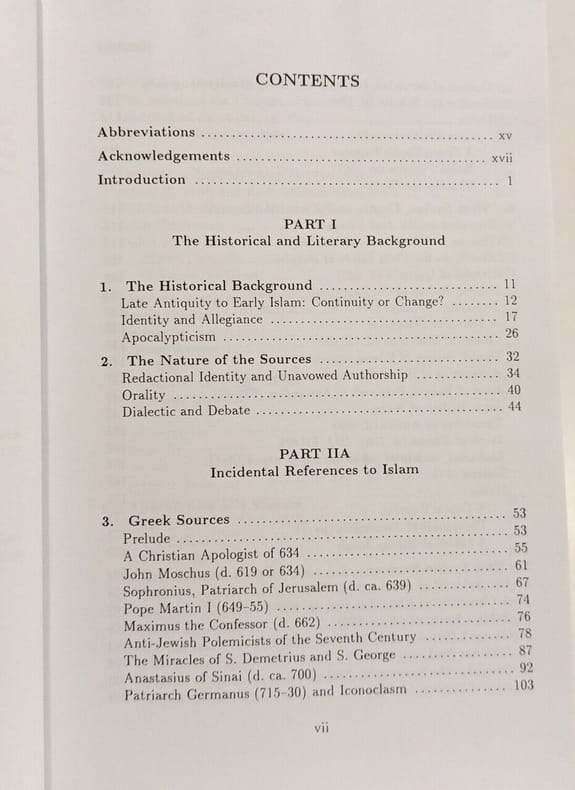
1998100144015Darwin Press Inc 1998 872 pages 16 256x4 064x24 13cm. 1998. Cartonné. 872 pages. Cet ouvrage académique de Robert G. Hoyland propose une étude et une évaluation des écrits chrétiens juifs et autres sources non-musulmanes concernant les premiers siècles de l'Islam (environ 620-780 apr. J.-C.). Il rassemble et analyse environ 120 textes primaires en grec syriaque copte arménien latin persan et chinois pour offrir une perspective externe sur la formation de la tradition islamique
New English Paperback. Pbo. Roy. 8vo. (24 x 17 cm). In English. 230 p. Security and defense perspectives beyond 2010. Preface Table of Contents Introduction R. Gen. Yasar Büyükanit Change of Defense in Turkey Gordon England The Transformation of U.S. Defense Lt. Gen. Jim Solligan The Transformation of Defense: NATO Prof. Erhan Büyükakinci War and History: Methodological Debates Prof. Li Wang The Chinese Defense Concept and Its Strategy Since 1979 Dr. Polina Temerina Russian Arms Transfer Policy Under Putin and Medvedev Prof. Hüseyin Bagci Turkey's Changing Geopolitics Prof. Efrahim Inbar Small Wars: Theory & Practice Dr. Giovanni Ercolani Security: Between Orthodoxy and Liquidity Prof. Mesut Hakki Casin Mass Media Strategies on the International Terrorism Larry D. White Is the Concept of Proportionality Still Valid in the CNN Age? Prof. Holger H.Mey The Role of Technology in Security and Defense Asst. Prof. Sait Yilmaz Transformation of Defense Evelyn A. Early Public Diplomacy and Counter Extremism Prof. Kamer Kasim Russia's Policy Towards the Black Sea and The Caucasus Muzaffer Akyildirim Turkey's Role in ESDP and EDA Antonia-Denisa Staedel Ethical Issues Regarding the Tactic of Targeted Killing Dr. Mireille Sadège The Defense Strategies of NATO in The Post Cold War Prof. S. Gulden Ayman NATO's Evolution And Turkey Abbreviations.
20 x 13 inches. Hand-coloured. Fine example of De Jode's modern map of the Middle East, from his Speculum Orbis Terrae, published in Antwerp in 1578 and engraved by Joannes & Lucas van Deutecum. The complete title reads: "Secundae partis Asiae: typus qua oculis subijciuntur itinera nautarum qui Calecutium Indiae mercandorum aromatum caufa fre quentant, ac eorum quoqz qui terrestri itinere ade unt Suacham, Laccam, in domino Praeto Iani, nec non eorum qui Aden et ormum inuifunt, et Balsaram quoque castrum, supra Euphratem fluuium situm, omnia suis gradibus subiecta, cum longitudinis tum latitudinis / Iacobo Castaldo pedemontano authore; Gerhardus de Iode excudebat". As noted in the title, the map was prepared by Gerard De Jode's and is largely identical to Giacomo Gastaldi's highly influential map of 1559. De Jode's delineation of Arabia is vastly superior to the contemporary maps of Ortelius, showing far more accuracy and detail. Extending from the Nile to Afghanistan and centered on the Arabian Peninsula and the Gulf, the map depicts what was then still among the most important trading centers of the commercial world. The present example is from the first edition of De Jode's work, which can be distinguished from the second edition by the pagination on the verso (VII for the 1578 edition; 9 for the 1593 edition). The map is drawn from the rare first edition of De Jode's Speculum Orbis Terrarum. At least one commentator has opined that as few as 11 known examples of the first edition are known to have survived, making separate maps from this first edition very rare on the market. - Giacomo Gastaldi (fl. 1542-1565) is widely considered to be the most important and influential of all of the Lafreri School mapmakers. Born in Piedmont, Gastaldi worked in Venice, where he become Cosmographer to the Venetian Republic. Karrow described him as "one of the most important cartographers of the sixteenth century. He was certainly the greatest Italian mapmaker of his age..." While his achievement is obvious, it is hard to quantify. A large number of maps were published throughout this period with the geography credited to Gastaldi, but it is often difficult to know what role Gastaldi played in their creation. As a practice, he did not sign himself as publisher, although his name may be found in the title, dedication, or text to the reader. Frequently where there is no imprint one may assume that Gastaldi was the publisher. A further clue may be that many of the maps attributable to Gastaldi as publisher seem to have been engraved by Fabius Licinius. In other cases, where publication is credited to another, it is not always certain whether Gastaldi was commissioned by the publisher to compile the map, whether another less-enterprising publisher merely copied his work and attribution, or simply added Gastaldi's name in the title to add authority to the delineation. His name clearly commanded the same sort of respect that the Sanson name had in the last years of the seventeenth century, and as Guillaume de L'Isle's had in the first half of the eighteenth century. Gastaldi's first published map was of Spain, engraved on four sheets, and issued in 1544. The following year he published a map of Sicily, among the most widely copied of all his maps. In the course of a prolific career, Gastaldi subsequently produced a number of maps of Italy, and individual parts of the peninsula, with his general map of Italy, and the map of Piedmont also being very influential. Among the most important of his maps, however, were of areas outside Italy. Principal among these was his map of the World, published in 1546, a four sheet map of the countries of south-eastern Europe, published in 1559, and his series of three maps of the Middle East, Southern Asia, and South-East Asia with the Far East, issued between 1559 and 1561. In 1562, Gastaldi issued a two-sheet map of the Kingdom of Poland, and in 1564, a magnificent eight-sheet map of Africa. Karrow, Mapmakers of the Sixteenth Century, 30/91.2. Tibbetts, Arabia in Early Maps 38.
Large folio (ca. 37 x 57 cm). 1 p. Traces of folds; some slight paper flaws. Austrian revenue stamp (50 kreuzers), dated 1888, affixed to upper left corner. Calligraphic notes in Ottoman Turkish on reverse (ink somewhat oxydized).
Engraved map of the Indian Ocean, Indian subcontinent and most of the Gulf region (28 x 39 cm; margins extended to 50 x 66.5 cm), at a scale of about 1:13,500,000 with north at the foot, with the equator reticulated with longitudes based on a prime meridian through Cape Verde, reticulated scales of latitude in the left and right borders, the Tropic of Cancer not reticulated; 3 sea monsters, a spouting whale and 3 ships in the ocean; and on the land elephants, lions and 2 people on horseback carrying spears. Rare very early engraved map showing the Indian subcontinent, the Strait of Hormuz, the eastern half of the Gulf, and the Indian Ocean, including the islands of Ceylon (Sri Lanka), the Maldives, Seychelles, the western tip of Sumatra and what must be the eastern tip of Somalia. The island Diego Garcia (7° S), labelled "Isole de Don Garzia", touches the southern edge of the map image. The map's own scales indicate that it covers 35°N to 9°S and 60 to 120°E (labelled 85 to 145°E following the Cape Verde prime meridian), but in fact it covers about 60 to 96°E. It is double trapezoidal projection, but tapers only slightly from its widest point at the equator. Many topographic names appear in forms used in early Portuguese accounts of voyages, but most can be identified. In India and Ceylon we find Goa, Mangalor (Mangalore), Cochin (Kochi), Calinapata (Calcutta?), Besinagar (Bangalore), Colmucho (Colombo) and many others; in the Gulf region Cor. Dulfar (Dhofar), the island Macira (Masirah), C. Resalgate (Ras el Had?), Galatia (the ancient site Qalhat), Mazcate (Muscat), the island Quexumo (Qeshm) and Ormus (Hormuz). There is even an unlabelled city close to present-day Abu Dhabi. Two of the ships are labelled with their destinations: Calicut (Kozhikode) on the Malabar Coast and Molucche (the Moluccas) in the East Indies. - Gastaldi first published a similar map as one of a set of three woodcut maps in the first volume of the second edition of Giovanni Battista Ramusio,Navagationi et viaggi, Venice, 1554: the "Prima tavola" shows Africa, the "Seconda tavola" shows the regions in the present map and the "Terza tavola" shows Southeast Asia and the East Indies. These were a great advance on earlier maps, including even Gastaldi's own, taking account of new information from Portuguese explorers. - The woodblocks and whatever copies of the printed edition had not yet been sold were destroyed by a fire in 1557, so for the 1563 edition the publisher had the three maps engraved on copperplates by Niccolo Nelli. Bertelli published the three maps without Ramusio's text, and his maps are usually supposed to have been printed from the 1563 plates, but Karrow describes them as close copies, with his name and the date 1565 added in each map, and Bertelli was an engraver as well as a publisher. Although the first map also has a longer note referring to all three maps, they were probably issued separately as well. Although printed from a single copper plate, the present map image is divided into two parts, with a 7 mm gap between the right and left halves, so that nothing would be lost if the map were bound as a double-page plate. No later state is noted in the literature, so there may have been multiple printings with the unrevised plate. - The present copy is printed on a whole sheet of paper, watermarked: coat of arms (77 x 44 mm) bearing a tree on the central and highest of three hills = --, with about 38.5 mm between chainlines except that the mark is centred on a chainline only 25 mm from the adjacent ones. The tree clearly matches the style of the oak tree in the arms of the family Delle Rovère, including the Popes Sixtus IV and Julius II (who served 1471-1484 and 1503-1513), but their arms does not include the hills. The present mark is very close to Briquet 969 (Lucca 1573-1582) and Zonghi 1737 (Fabriano 1571). Likhachev 3636 (an Italian manuscript f ca. 1570) is not as close. All similar marks noted in the literature date from the period 1569 to 1582, so the present map seems unlikely to have been printed in 1565, but very likely to have been printed ca. 1570 (Bertelli remained active to ca. 1580 or perhaps even later). Bifolco & Ronca lists copies of the 1563 (84a) and the present 1565 (84b) state or edition together, but their separate lists of references suggest the present 1565 version is much rarer. - The margins have been cut down close to the plate edge and in places to the outer edge of the border, and the margins then greatly extended (10-14 cm) with blank paper, but this paper is also contemporary, watermarked: coat of arms bearing a ladder and topped with a 6-point star (90 x 27 mm) = --, similar to Likachev 3524 (Loreto 1564). The map is very slightly browned at the edges (where the pieces of paper used to extend the margins were pasted together) and in the gap between the right and left halves (where the old fold has been reinforced on the back), but the map is otherwise in fine condition. A milestone in the cartography of India and the Gulf States, remarkably well preserved. Bifolco & Ronca, Cartografia topografia Italiana, 84b. Gole, Early printed maps of India, 2. Karrow 30/74.2.
Large 8vo. XII, 331, (1) pp. With wood-engraved frontispiece of the Homra tree. Original publisher's brown boards with title in gilt to spine. First edition. - The Lebanese Maronite Churi trained at the Congregation of Propaganda in Rome from 1842 to 1849. He later left Rome and made his way to London, where he gave lessons in Arabic, Latin, Italian, and Hebrew. Captain W. Peel was amongst his pupils and persuaded him to accompany him on a tour of the Middle East between October 1850 and February 1851. The present work is an account of a second journey the pair undertook to Egypt and the Sudan between August 1851 and February 1852. - Some wear to spine and boards. Mild occasional foxing, otherwise in very good condition. Nice original, unblemished yellow endpapers. Rare. Ibrahim-Hilmy I, 135 (erroneously s. v. "Chusi"). OCLC 4709982. Not in Gay.
185414601Extrait de La Revue des deux mondes | s. l. [Paris] (1854) | 15.50 x 25 cm | agrafé
1469London Religious Tract Society Ca. 1840. 1st Edition . Hardcover. . ~ ~ NOTE: THE PRICE OF THIS BOOK IS CURRENTLY REDUCED! ~ ~ . Crown quarto. Unpaginated. Ca. 100 pages of text. Plus 25 hand-coloured engraved plates each with facing tissue guard including frontispiece. Engraved vignette on title-page. Engraved tail-pieces. HARDCOVER bound in the original publisher's blue full cloth gilt illustration on cover gilt spine sides with ornaments embossed in blind all edges gilt; extremities worn inner hinges cracked lacks last free endpaper; sporadic small stains and finger smudges one plate repaired on verso. In good condition. ~ FIRST EDITION. This is the rare edition with hand-coloured plates marked with the words "Coloured Plates" in gilt at foot of spine. The quality of the colouration is very high with dense and rich dyes and most plates are clean and well preserved. E-4 OUT <br/> <br/> London, Religious Tract Society, Ca. 1840. hardcover
1470London Religious Tract Society Ca. 1840. 1st Edition . Hardcover. . ~ ~ NOTE: THE PRICE OF THIS BOOK IS CURRENTLY REDUCED! ~ ~ . Crown quarto. Unpaginated. Ca. 100 pages of text. Plus 25 hand-coloured engraved plates each with facing tissue guard including frontispiece. Engraved vignette on title-page. Engraved tail-pieces. HARDCOVER bound in the original publisher's brown cloth neatly re-spined with plain cloth gilt illustration on cover sides with ornaments embossed in blind all edges gilt; extremities bit rubbed inner hinges cracked; few small spots. In good condition. ~ FIRST EDITION. This is the rare edition with hand-coloured plates. The quality of the colouration is very high with dense and rich dyes and most plates are clean and well preserved. E-4 OUT <br/> <br/> London, Religious Tract Society, Ca. 1840. hardcover
Mm 115x170 Collana "Le piccole storie illustrate". Volume in copertina rigida, sovraccoperta editoriale, 134 pagine con 16 figure su tavole fuori testo. Buona copia, spedizione in 24 ore dalla conferma dell'ordine.
Very Good English Paperback. Pbo. Demy 8vo. (21 x 15 cm). In English. 26 p. Scientific collaboration of the Islamic Orient and the Occident. A lecture delivered in the Faculy in the Law on 17th May 1950.
Title page and 38 unnumbered pages of text. Half cloth binding from around 1870 with gilt spine-lettering and marbled boards. This is a preliminary outline of the material to be covered extensively in Ludolf's "Istoria Aethiopica", which was published in three volumes from 1681 to 1693. Job Ludolf, a German German scholar, and the "founder of Ethiopian studies" (Katalog der Eutiner Landesbibliothek) gathered the most important information available about Ethiopia in his time, working for a time in collaboration with one of the Ethiopian monks who stayed in Rome. In addition to his monumental history of the country, he wrote dictionaries and grammars of Ge'ez and Amharic. His intensive studies of Ethiopian culture and life made his work the best 17thcentury source on the region described. "A most important work on Abyssinia" (cf. Paulitschke), "of an importance transcending his own time". Very good condition outside, text shows browning and foxing. Stamp on reverse of title page. A particularly scarce and hardly known work, preceding Ludolf's famous publication on Ethiopia by a full 5 years and at the same time Ludolf's very first publication!
8vo. (24), 255, (1) pp. Contemporary calf with gilt spine; leading edges gilt. All edges sprinkled in red. First edition of this Syriac textbook, including one of the earliest investigations of the Samararitan language and script. "It is the least developed among the Semitic languages, closest to Syriac, but coarser, even less sophisticated. The Samaritan population has greatly dwindled; their capital is Nablus in Palestine, but there are also some in Damascus, Cairo, Acre and other places. Their common language is Arabic" (cf. Vater/J.). The Utrecht philologian J. Leusden (1624-99) studied philosophy in his hometown, then focused on theology and the oriental languages. He was ordained as a preacher in 1649. He subsequently moved to Amsterdam, where he took instruction in Hebrew and Talmudic scholarship from various Jewish teachers, including one of Arabian descent, and thus acquired such learning that he succeeded to the Utrecht chair of Hebrew and Jewish Antiquities in 1651 (cf. Jöcher 2409). - Binding somewhat rubbed. Ownership "J. Venturi" (dated 1805) on title page. Vater/Jülg 323. Jöcher II, 2410. Jöcher/Adelung III, 1728, 4.