1 365 résultats
(Milano), Garzanti, (1941), in-8, br. edit., pp. VIII, 256. Con 6 cartine e 12 illustrazioni in b.n. f.t. Mancanze al dorso ed alla cop. posteriore, ampi aloni di umidità.
193524EwParis Payot 1935 In8 279 pages - broché - 5 cartes - dos recollé - etat satisfaisant
Mm 150x225 Brossura editoriale con sovraccoperta illustrata a colori, 256 pagine con 12 illustrazioni e 6 cartine fuori testo. Traduzione di Elsa Asinari di S. Marzano. Qualche fioritura e ordinari segni del tempo alla sovraccoperta (una menda al dorso), peraltro buona copia. SPEDIZIONE IN 24 ORE DALLA CONFERMA DELL'ORDINE.
772LOndon, FISCHER UNWIN, New-York PUTMAN'S 1891, IN8 cartonnage dec.editeur,percaline verte, with maps, many illustrations,a chronologi cal table ans a list of books treating the subject,
28243Tours, Alfred Mame & Fils,1884 - In-8 - Reliure chagrin - Dos à faux nerfs orné - 213 pages. Gravure en noir et blanc en frontispice. Illustré de nombreuses gravures en noir et blanc dans et hors texte - Illustrations de Yan'Dargent, Foulquier et W. Freeman - 213 pages - Bel exemplaire - Envoi rapide et soigné
Tours, Alfred Mame & Fils,1884 - In-8 - Reliure chagrin - Dos à faux nerfs orné - 213 pages. Gravure en noir et blanc en frontispice. Illustré de nombreuses gravures en noir et blanc dans et hors texte - Illustrations de Yan'Dargent, Foulquier et W. Freeman - 213 pages - Bel exemplaire - Envoi rapide et soigné
1999PHO-465Lawrence: The Uncrowned King of Arabia , Londres ,1999 ,penguin books in-8 (23x13cm), 418pp, nombreuses illustrations en noir et couleurs ,demi chagrin et coin , dos à nerfs, bel exemplaire, couverture conservée P2-6E
8vo., First Edition, with numerous coloured and monochrome plates, and maps in the text; brown cloth, gilt back, beige endpapers, a fine copy in unclipped dustwrapper.
20152Paris, Adrien Maisonneuve 1969, 250x160mm, 288pages, reliure d'éditeur. Bel exemplaire.
2004VOY4421MRelié, 368 pages, paru en 2004 chez Chandeigne, livre en très bon état général. Nous avons d'autres exemplaires des éditions Chandeigne, retrouvez les dans notre catalogue grâce au mot-clé "Chandeigne".
Outside dimensions 7.5" x 10.5". Circa 1902. Centerfold. Light wear. Please see our photo for details. Book
157 pages. Large lavishly illustrated glossy colour photographic pictorial presentation of the Kingdom. Text in English, French and German. Undated. Circa early 1980s? Unmarked. Moderate wear. Nice copy. Undated. Book
in-8°, 189 pages, broche. Bel exemplaire. [PAY]
Minor edgewear. Bumping to base of spine. ; Looks at the life and actions of the Crown Prince of Saudi Arabia. Heavy Book. ; 269 pages
4°, TELA NERA EDITORIALE CON TITOLO BIANCO AL DORSO E MOTIVI IN ARABO AL PIATTO, SOVR. CON FOTO A COLORI, PG. 203 (5), NOTEVOLE REPORTAGE FOTOGRAFICO A COLORI (PREVALENZA PIENA E DOPPIA PG.), INTRODUCTION BY PRINCE SAUD AL FAISAL, BUONO STATO. FIRST EDITION.
190671516Par Karl Baedeker, Avec 20 cartes, 52 plans et un panorama de Jérusalem, Troisième édition, 1 vol. in-12 reliure éditeur pleine percaline souple rouge, Karl Baedeker Éditeur, Leipzig, Paul Ollendorff, Paris, 1906, XCVI-429 pp.
Narrative is 53 pages, plus black and white photographic plates, and a large fold-out colour map measuring approximately 11 x 9 inches (28 x 23cm). In original condition, published in two separate consecutive monthly issues of the Geographical Journal. Seldom found in such very good condition, two complete issues with blue wrappers, titles to front, and containing all the ads. Major Bagnold's third journey into the Libyan Desert concentrated on three relatively broad fields of inquiry that included the area's series of geological events; the compilation of a fairly complete account of the series of strata present and the examination of sand sheets. Also features Sandford's geology and geomorphology of the southern Libyan desert; a section dedicated a history of the area's rainfall; sand and sand dunes: the Malha crater; the barchan dune; whalebacks, undulations or billows; sand drifts, as well as fascinating appendices relating to ornithology, entomoloy, botany, cartography, barometric altitudes, transport arrangements, food and costs of the expedition.
33 pages, inluding sketch illustrations. Plus black and white photographic plates and a large fold-out colour map measuring approximately 16 x 9 inches (40 x 23cm). Original condition with blue wrappers, titles to front, and containing all the ads. This is a complete issue, seldom found in such good and original condition. This is a detailed first-hand expedition report of discoveries made by accomplished Libyan Desert explorer Ralph A. Bagnold. Although retired from the military since 1935, Bagnold remained a desert explorer. With the aid of the Egypt Exploration Society, in 1938 Bagnold organized his most ambitious scientific expedition to the Gilf Kebir and Uweinat. While on this venture, fellow explorers, Hans Winkler, recorded rock art at Karkur Talh, and Oliver Myers excavated two main neolithic sites in the Gilf Kebir, in Wadi Bakht and Ard al Akhdar. Bagnold and Shaw also discovered a new rock art site in Karkur Murr, and one also in Wadi Abd el Melik in the Gilf Kebir. With contributions by Bagnold's expedition members Myers, Peel and Winkler, this comprehensive dissertation is clearly outlined in sections dealing with the Sir Robert Mond expedition, archaeological work - specifically of Palaeolithic sites and later sites, on rock-drawings and paintings, Tibu (Guraan Remains), dramatic features and craters of the Gilf Kebir, rock pictures at Uweinat, Sand Movement and Dunes, and a section describing logistics such as transport, navigation and supplies. This is Bagnold's preliminary reveal of critical findings, which precedes the release of his book, 'The Physics of Blown Sand and Desert Dunes' which was not published until 1941. A marble plaque in memory of Bagnold's 1938 Egypt Exploration Society's Expedition was later placed along the Tropic of Cancer at Gilf Kebir by the Zarzora Expedition.
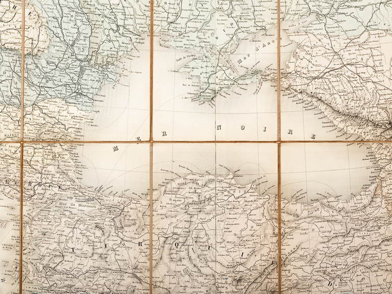
58 pages (Complete with all three parts, as published, in 3 consecutive issues of the Royal Goegraphical Society). Plus many photographic plates and a large fold-out color map, measuring approximately 16 x 12 inches (41 x 30cm). Original condition with blue wrappers, titles to front, and containing all the ads. Three complete issues, seldom found in such good and original condition. This is one of the most comprehensive and valuable report on the Libyan Desert, in which the author attempts to elucidate some of the important questions and problems concerning depressions, oases, and water supplies, accompanied by many incredible photographic plates and a spectacular large fold-out colour map of the Libyan Desert showing surface-relief, contours of static underground water-levels, distribution of sand-dunes, as well as routes of principal exploratory expeditions in the west and south including those of Rohlfs in 1874&1879, Hodgson in 1901, Comyn in 1906, Harding King in 1911, Ball & Moore in 1917, Mrs. Forbes & Ahmed Hassanein in 1920, Ahmed Hassanein in 1923, Bruneau de Laborie in 1923, and Prince Kemal el Din in 1925&1926. The fascinating subjects discussed in this extensive report include: whether the Nile, or a branch of it, ever flow through the Libyan Desert to the west of the present Nile Valley; origin of the depressions; the possibility of utilization of depressions in the Libyan Desert for irrigation, drainage, or hydraulic power; the origin of the artesian water supplies of the Egyptian oases of Baharia, Kharga, Dakhla, and Farafra; permanence of lakes and salt-marshes occupying the depressions of Areg, Bahrein, Sittra, and Qattara; whether the present water-supplies of the Mediterranean littoral can be supplemented by artesian borings; the possibility of the artesian water supplies of the oases diminishing; mysterious "Zerzura, or Oasis of the Blacks"; the possibility of traveling in Great Tracts of the waterless Libyan Desert by the sinking of new wells; the "Tortoise Marshes" of Ptolemy; the sand-dunes; and the distribution of stone implements. Also with references to the Pottery Hill, found by Dr. Ball in 1917, and Prince Kemal el Din's expeditions in 1923 and 1925
1954123705Amiot-Dumont, 1954, in-8°, 190 pp, 16 pl. de photos hors texte, 2 cartes, broché, jaquette illustrée, bon état
19573130366Palermo: Manfredi 1957. XV, 98 Seiten. 8° (17,5-22,5 cm). Orig.-Broschur. [Softcover / Paperback].
1938785821938 Paris, Corréa, 1938, in 12 broché, 162 pages ; portrait en frontispice et photographies hors-texte.
190426332Carte entoilée en couleur au format 94 x 68 cm, échelle 1 : 3500000, Maison Andriveau-Goujon, Henry Barrère, Paris, 1904 (mention rev. 1904), carte n° 15, atlas usuel n° 21 ; atlas universel n° 34, gravé : le trait par Smith, la topographie par Gérin, les Ecritures par Rousset, les Eaux par Mme Fontaine
Carte entoilée en couleur au format 94 x 68 cm, échelle 1 : 3500000, Maison Andriveau-Goujon, Henry Barrère, Paris, 1904 (mention rev. 1904), carte n° 15, atlas usuel n° 21 ; atlas universel n° 34, gravé : le trait par Smith, la topographie par Gérin, les Ecritures par Rousset, les Eaux par Mme Fontaine Belle grande carte entoilée de l'Empire ottoman (petites usures aux pliures, une petite annotation marginale). Français