STEWART Desmond -MareMagnum

1 365 résultats
Milano, Mondadori, 1963, 4to tutta tela con copertina illustrata a colori, pp. 159 con numerosissime illustrazioni in nero e a colori. (Life - Club degli editori)
Milano, Club degli Editori, 1963, in-8, cart. edit., pp. 160. Con numerose ill. in b.n. e a col. e bibliografia.
Slight wear to price clipped DJ. Slight browning to endpapers; Originally published in 1961 and revised twice to reflect changes in Iranian society; 8vo; 332 pages
196599119Grasset, 1965, in-12, 264 pp, biblio, broché, couv. illustrée à rabats, bon état. Edition originale sur papier courant
1960PHO-678Paris, Gallimard, 1960, in-12, plein bas. rouge, dos à nerfs. 275Pp , nombreuses illustrations bel exemplaire .
8 pages. Plus photographic plates and a large fold-out colour map measuring approximately 17 x 14 inches (43 x 36cm). Original condition with blue wrappers, titles to front, and containing all the ads. This is a complete issue, seldom found in such good and original condition. Narrative of a fascinating expedition into the innermost recesses of ancient Persia, for the purposes of documenting some of the oldest monuments in the history of civilization. Beautifully illustrated with plates and a stellar fold-out colour map of the Fars Province. Features exploration of Persia's northern Province of Fars host to the great Achaemenian sites of Persepolis and Pasargadae. Includes the citadel of Qala-i-Gabri; the palace below Tang-ab gorge; Firuzabad, a ruined Sasanian palace in Sarvistan; the Mound of Tal-i-Zohak in Fasa, and that known as the castle of Bahram, Dehbid; the reservoirs built along cliffs above the ruined 'Town of Ij;' the colossal rock sculptures at Nakhsh-i-Rustam, Darab and much more. Trained as an orientalist and archaeologists, he planned several expeditions to the interior of Asia and used Sanskrit, Persian, Chinese, Turkish, Greek and Latin as scholarly tools to unlock the geographical puzzles, in the process making valuable topographical surveys and penned down his experiences in his famous books. This expedition took him into the heart of Persia, modern day Iran. Iran has a long and rich history, with some of the most famous conquerors and war lords ever to dominate the continent of Asia. Some of the world's most ancient settlements have been excavated in the Caspian region and on the Iranian plateau; village life began there c.4000 B.C. The Aryans came about 2000 B.C. and split into two main groups, the Medes and the Persians. The Persian Empire founded (c.550 B.C.) by Cyrus the Great was succeeded, after a period of Greek and Parthian rule, by the Sassanid in the early 3d century A.D. Their control was weakened when Arab invaders took (636) the capital, Ctesiphon; it ended when the Arabs defeated the Sassanid armies at Nahavand in 641. With the invasion of Persia the Arabs brought Islam. The Turks began invading in the 10th century. and soon established several Turkish states. The Turks were followed by the Mongols, led by Jenghiz Khan in the 13th century and Timur in the late 14th century.
50 pages, in two consecutive issues as published. Plus photographic illustrations, and a fold-out color map measuring approximately 9 x 7.5 inches (23 x 19cm). Original condition with blue wrappers, titles to front, and containing all the ads. Two complete issues, seldom found in such good and original condition. The famous author's groundbreaking explorations between Upper Swat and the Indus in 1926 are passionately recounted by him in this preliminary report. During the archaeological tour of Graeco-Buddhist remains in Swat (now in the far north of Pakistan), Stein located Alexander's trail and traced it to Pir Sar at a bend in the Indus. Stein's main object was indeed to personally follow the track of Alexander the Great in the region, as far as it was accessible outside of Afghanistan. Prior to the discussion of the exploits described in this work, this region was beyond the administrative border of the Indian North-West Frontier, and was inaccessible to Europeans. This is the first major Western account of these areas. Stein's account pre-dates his important book by two years, "On Alexander's Track to the Indus. Personal Narrative of Explorations on the North-West Frontier of India," first published in 1929. Aurel Stein's surveys were inspired by archaeological and historical interests, and his fascination with the cultures of Cental Asia. Trained as an Orientalist and archaeologist, he planned several expeditions to the interior of Asia and used Sanskrit, Persian, Chinese, Turkish, Greek and Latin as scholarly tools to unlock the geographical puzzles, in the process making valuable topographical surveys and penned down his experiences in his famous books. The routes and battlefields of Alexander’s campaign in the east had been a long-standing interest of Stein’s and whilst surveying for the Indian Government on the North-West frontier he was able to indulge his fascination. (Yakushi S336).
30 pages, plus numerous photographic plates, and a large fold-out colour map measuring approximately 18 x 15 inches (46 x 38cm). Original condition with blue wrappers, titles to front, and containing all the ads. This is a complete issue, seldom found in such good and original condition. Aurel Stein's surveys were inspired by archaeological and historical interests, and his fascination with the cultures of Central Asia. This work describes Stein’s last and longest of four journeys which carried him during the years 1932-1936 through an extensive belt of Southern and Western Iran. Featuring the Tang-i-Khas valley; Pul-i-Murd, the Bridge of the Myrtles; the rock cut tomb of Da-u-dukhtar, Deh-i-nau valley; the bridge above Khairabad, Behbehan; the watch station at ruined town of Deh-dasht, Kohgalu; Tang-i-Sarvak valley; the ruined bridge over the Saimareh below Hulailan and over Kashgan river; the Chigha-pahan mound, Koh-i-dasht; Tang-i-Gaushumar gorge, Kashgan river; the Luristan grave at Chigha-barinda, Tarhan; the early Mohammaden bridge at Samaq; the rock-cut wall above a spring at Harsin and much more.
16 pages, including a full-pages sketch map. Plus a few photographic plates. Original condition with blue wrappers, titles to front, and containing all the ads. This is a complete issue, seldom found in such good and original condition. This is an incredible account delineating two successive archaeological expeditions in 1932-33, into ancient Gedrosia, or Persian Baluchistan, and into the eastern portion of the Kerman province and along the coast of the Persian Gulf, commenced by an eminent Hungarian-British archaeologist, Sir Aurel Stein, replete with valuable information on archaeoligical discoveries of ancient sites from prehistoric to early Muhammadan, illustrated with a full-page sketch route map of Aurel Stein's journey in Southern Persia, showing the ancient sites of Haraj, Tal-i-Iblis, Takkul, Katukan, and Damba-Koh, as well as, Muhammadan remains in Tahiri (ancient Siraf), Leshtan, Hormuz (Ormuz), Camadi, and Giti. Also includes spectacular photographic plates depicting rock-cut graveyards of old Siraf, funerary deposits at Khurab burial site, Fort of Minab, interior of ruined stronghold of Leshtan, and burial cairns of Damba-Koh. The author commences his journey from Gwadar to Bam - the total of distance of the journey done on camel-back was around 1200 miles - thence to Kerman on motor lorries, from there to Bushire (Bushehr), on the way back home to England, he stops at Persepolis to enjoy the magnificent ruins which was being explored by Professor Herzfeld, then embarks for Basra, reaches Baghdad by railways, thence to Constantinople and England. A highly valuable expedition report containing fascinating depiction of archaeological discoveries some include: the ruins of the "Castle of Jamshid", located above the Giti valley, where the author found abundant remains of decorated ceramic from late Sasanian and early Muhammadan times; decorated pottery, copper coins, and beads found in the Valley of Tiz; cemeteries of rock-cut Mohammadan graves; prehistoric remains found within Fanuch oasis; relics of prehistoric civilization in Bampur including ceramics, alabaster cups, stone implements, and bronze objects from chalcolithic times; remains of funeral deposits of chalcolithic times in Katukan; discovery of prehistoric remains on the left bank of Bampur river below Fahreh, such as elaborate funerary deposits and well-painted vessels meant to hold food for the dead; ruined site at the head of the Jiruft basin, known as "Town of Daqianus", where he found abundance of pottery frangments, mostly glazed or relief-decorated as well as numerous coins; ancient site of Tal-i-Iblis; evidence of prehistoric occupation near the hamlets of Daruyi and Nurabad; evidence of mediaeval maritime intercourse with India and the Far East at Bandar Muqam; ruined site of Siraf, discovery of early prehistoric remains near the village of Haraj. Also with some fascinating remaks on Minab, the important trade port of Hormuz (Ormuz) and its ruined Portuguese castle, Bandar Abbas, Bandar Lingeh, and Bushire.
116176aafParis, “Je sers”, 1938, pt. in-8vo, 383 p., frontispice (portrait de Freya Stark), + 1 carte, ill. n./b., brochure originale.
in-8°, broche de 357 pp., couverture illustree. illustre de photos en noir + carte. Edition originale dont il n'est pas annonce de grand papier. Coin superieur du 1er plat decoupe en oblique sur 2 cm sinon bel exemplaire. [DV-8]
Wear with chipping, staining, and open tears to price clipped DJ. Residue to endpapers. Front hinge started. Binding not tight ; Author Stark searches for the trail of Alexander the Great ; B&W Photographs; 8vo; 283 pages
14714Paris Éditions ''Je sers'' 1947 in 12 (19,5x14,5) 1 volume broché, 294 pages. Bon exemplaire
Light wear to DJ. Boards slightly faded. Top corners bumped; Beautiful fold-out map at rear. A history of the frontier of the Euphrates river through 800 years of Roman warfare. Up to the time of writing, the country had changed very little; B&W Photographs; 8vo; 481 pages
Item is in Original Condition, with Blue Wrappers - As Issued, Complete with All the Ads!!! Notes & Condition: This is an exceptional report detailing the author's journey into little-known Luristan and her facinating archeaological findings. She travelled from Nihavand over the Varazan Pass to Khava, then to Alishtar and back again though Khava to Difan, Chavarti, Duliskan and finally to Tudaru. In 1931 Stark had attempted to reach the middle of Luristan, the country of Tarhan east of the Saidmarreh river, where ancient tombs were rich in bronzes, but she was prevented entry by the Persian Police. Excerpt from the text: "I have written elsewhere the account of the actual travelling and its adventures, and will confine myself to what concerns the graves and their possible history. Special interest has been centred on those graves which are said to contain the trappings of horses and chariots, for the origins of the people who used such things may throw light on the coming of the horse into Persia.... I found a few older objects among the Islamic in Alishtar: some glass beads, silver earrings of the usual Luristan type, and a bronze arrow-head; but could not ascertain the exact spot where they had been found." End Excerpt. 8vo. 8 pages, plus 2 photographic plates for illustration. Original condition with blue wrappers, titles to front, and containing all the ads. This is a complete issue, seldom found in such good and original condition. This account pre-dates Stark's "The Valley of the Assassins: And Other Persian Travels," first published in 1934.
7 pages. With a full page sketch map and two photographic illustrations. Original condition with blue wrappers, titles to front, and containing all the ads. This is a complete issue, seldom found in such good and original condition. This is a fascinating expedition report on the ancient site of Kalar, located in the Elburz mountains on the borders of Gilan and Mazanderan. An incredible account on the mighty harsh regions of the Elburz mountains and the ancient site of Kalar, long a stronghold for the Zoroastrian way of life during the brutal regime of autocratic Persia and Islam.
Book is in excellent condition. Binding is solid and square, covers have sharp corners, exterior shows no blemishes, text/interior is clean and free of marking of any kind. Beige buckram cloth covers with deep red lettering on cover and spine. Book contains over 90 black and white photo illustrations, usually full page, by the female author, who also authored a volume of photos Seen in the Hadhramaut and wrote Baghdad sketches, The Vallys of the assassins, The southern gates of Arabia and travelled extensively in the region. Three maps. 329 pages with index. Publisher's page reads "First Edition." Contents include: Mukalla, Kathiri, Wadi Amd, High Jol, Azzan, Naqb al Hajr, Jebel Kadur, Sultan's Caravan, Cana, etc. wtih an appendix of Arabic plants. Dust jacket is now wrapped in clear protective cover.
Milano, 1950, stralcio con copertina posticcia muta, pp. 69/80 con numerose fotografie. - !! ATTENZIONE !!: Con il termine estratto (o stralcio) intendiamo riferirci ad un fascicolo contenente un articolo di rivista, sia che esso sia stato stampato a parte utilizzando la stessa composizione sia che provenga direttamente da una rivista. Le pagine sono indicate come "da/a", ad esempio: 229/231 significa che il testo è composto da tre pagine. Quando la rivista di provenienza non viene indicata é perchè ci è sconosciuta. - !! ATTENTION !!: : NOT A BOOK : “estratto” or “stralcio” means simply a few pages, original nonetheless, printed in a magazine. Pages are indicated as in "from” “to", for example: 229/231 means the text comprises three pages (229, 230 and 231). If the magazine that contained the pages is not mentioned, it is because it is unknown to us.
x + 265pp.+ 12 plates out-of-text & map, cloth, dustwrapper, 21cm., VG
1938sc515Editions Je Sers Broché 1938 In-12 (12 x 18,8 cm), broché, 383 pages ; ensemble bruni, pliures au dos, bon état général. Livraison a domicile (La Poste) ou en Mondial Relay sur simple demande.
8vo., First Edition thus, with portrait frontispiece and numerous photographs by the author; blue pictorial cloth, upper board and backstrip blocked and lettered in silver, blue/silver endpapers, a fine copy in publisher's board slip-case.
2298Paris - Hachette - 1898 - In-8 - Reliure éditeur, 1er plat "Lycée de Brest" - 21 illustrations PP HT - 284 p.
Paris - Hachette - 1898 - In-8 - Reliure éditeur, 1er plat "Lycée de Brest" - 21 illustrations PP HT - 284 p.
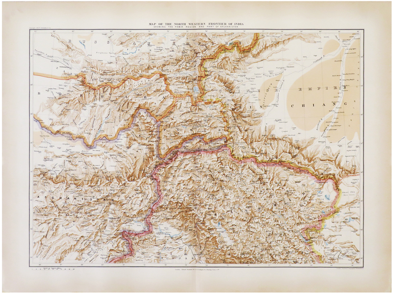
1896LBW-6821London, Edward Stanford, 1896. 470 x 640 mm.
19862090502113709227Not Available 1986. Soft Cover. Fine. The book is in fine condition. Not Available paperback