1 365 résultats
1764LBW025171764 243 x 354 mm.
Città del Vaticano, Biblioteca Apostolica Vaticana,1969/ 1970. DUE Voll. In 8°gr.pp.LIX+circa 200 nn.(Lingua e Scrittura Araba), Tavv.f.t.b.n.;pp.LV+314n.+2nn. bross.edit. (Esemplari Intonsi).
200164959Préface de Paul Veyne, 1 vol. in-4 cartonnage éditeur sous jaquette illustrée, Editions Imprimerire Nationale, 2001, 310 pp.
In 4. Dim. 28,5x20 cm. Pp. 1005+(3)+(5). Edizione del 1909 della collana "Nuova geografia universale" di Eliseo Reclus di questo volume sull'Asia Anteriore (volume IX). L'opera è in un volume ed in se completa. All'interno: Afganisthan (Montagne del Kafir, Kabul, Herat, KAndahar), Balutscistan, Persia, Turchia Asiatica, LAzistan, Armenia, Kurdistan, Litorale del Ponto, LAgo di Van, Alto Eufrate, Bacino del Tigri ed Eufrate, Basso Kurdistan, Mesopotamia, Irak-Arabi, Asia Minore, Cipro, Siria, Palestina, Sinai, Arabia ecc... All'interno sono presenti 155 carte intercalate nel testo, 85 grandi incisioni di vedute e tipi e 5 carte geografiche. In discrete condizioni ma completo. Copertina editoriale in discrete condizioni generali con usure ai margini e dorso. Rinforzi di carta ai piatti. Legatura in discrete condizioni con rotture. All'interno le pagine si presentano in ottime condizioni con rare fioriture, ancora unite fra loro. Edition of 1909 of the series "Nuova geografia universale" written by Eliseo Reclus of this volume about Asia (volume IX). The work is in one volume and it is complete. Inside: Afganisthan (Montagne del Kafir, Kabul, Herat, Kandahar), Balutscistan, Persia, Asiatic Turkey, Lazistan, Armenia, Kurdistan, Ponto Land, Lake of Van, Alto Eufrate, Basin of Tigri and Eufrate, Low Kurdistan, Mesopotamia, Irak-Arabi, Asia Minore, Cyprus, Syria, Palestine, Sinai, Arabia ecc... Inside there are 155 maps in the text, 85 big prints of views and people and 5 maps. In fair conditions but complete. Editorial cover in fair general conditions with wearings in the edges and spine. Paper reinforcement in the plates. Binding in fair conditions with cracks. Inside pages are in very good conditions with occasional foxings, still to be cut.
19594968EBWiesbaden, Franz Steiner Verlag, 1959. 4°. 25,5 cm. Nicht durchgehend paginiert. Original-Broschur. (= Bibliotheca islamica, Band 22).
1913157441913 Paris, Plon, 1913, in 12 broché, XXVII-291 pages ; carte dépliante.
10073In 12 broché, faux-titre, titre, une illustration en couleurs d’après une miniature, 256 pages, illustrations de l’auteur d’après les miniatures orientales. Paris Librairie des sciences politiques et sociales Marcel RIVIERE 1927.Bon exemplaire.
1927X112254Lund, Haran Ohlsson 1927 119pp., 25cm., text in English, Doctoral Dissertation (University of Lund), original softcover (with trace of a small label), pages still uncut, stamp at verso of title page, text is clean and bright, X112254
119pp., 25cm., text in English, Doctoral Dissertation (University of Lund), original softcover (with trace of a small label), pages still uncut, stamp at verso of title page, text is clean and bright, X112254
1960PHO-678Paris, Gallimard, 1960, in-12, plein bas. rouge, dos à nerfs. 275Pp , nombreuses illustrations bel exemplaire .
204775Edimbourg-Londres, Oliphant, Anderson & Ferrier, s.d. (1910) in-8, [3] ff. n. ch., 436 pp., avec des figures dans le texte, 18 planches hors-texte, et deux cartes dépliantes, dont une aux contours rehaussés de couleurs "in fine", toile orange, dos et plats illustrés (reliure de l'éditeur). Dos insolé.
Book is in excellent condition. Binding is solid and square, covers have sharp corners, exterior shows no blemishes, text/interior is clean and free of marking of any kind. Beige buckram cloth covers with deep red lettering on cover and spine. Book contains over 90 black and white photo illustrations, usually full page, by the female author, who also authored a volume of photos Seen in the Hadhramaut and wrote Baghdad sketches, The Vallys of the assassins, The southern gates of Arabia and travelled extensively in the region. Three maps. 329 pages with index. Publisher's page reads "First Edition." Contents include: Mukalla, Kathiri, Wadi Amd, High Jol, Azzan, Naqb al Hajr, Jebel Kadur, Sultan's Caravan, Cana, etc. wtih an appendix of Arabic plants. Dust jacket is now wrapped in clear protective cover.
3030704394.Gpaperback. Good. Access codes and supplements are not guaranteed with used items. May be an ex-library book. paperback
35 pages. Plus photographic plates and a large fold-out color map, measuring approximately 8 x 14.5 inches (20 x 37cm). Original condition with blue wrappers, titles to front, and containing all the ads. This is a complete issue, seldom found in such good and original condition. Interesting narrative from a learned source, Sir Percy Cox, adviser to the Sultan of Oman and long term resident of the Persian Gulf. Cox outlines journeys undertaken from Abu Dhabi to Baraimi and along the fringe of Oman on the desert side, to the Jabal Akhdhar or Green Mountains - a distance of about 400 miles; and also his trip from Ras al Khaima to Baraimi and to the coast at Shinas, along it to Sohar. Features descriptions of Oman's capital - Muscat, the Trucial coast, its principalities and the Great Pearl Bank, local fauna, 'the music of the sands,' Ras al Khaima, stronghold of the Jowasmi pirates, and most interestingly perhaps, encounters with local sheikhs. Accompanied by photographic plates and a large fold-out colour map, this narrative also includes comments and notes by veteran Arabia explorers such as H. St. J.B. Philby.
Two reports on Persia altogether 45 pages including a full-page sketch map, plus 2 large fold-out colour maps. In original condition with blue wrappers, titles to front, and containing all the ads. This is a complete issue, seldom found in such good and original condition. The first report: 24 pages, including a full-page sketch map, plus a large fold-out color map measuring 18.5 inches x 8.5 inches (47cm x 22cm). This is an exceptional expedition report on the Karun River and the commercial geography of south-west Persia, that pre-dates the authors all-important book, "Persia and the Persian Question", first published in 1892. The book is one of the most important books on Persia; dealing with every aspect of Persia, political, archaeological, cultural, etc., its great strength is its topographical section. As Ghani says, "his powers of observation and analysis were extraordinary; no detail ever escaped him. His book can still be used as a topographical guide for travel in Iran." Ghani 87. This makes this report a highly valuable important primary resource. The second report: 21 pages, plus a large fold-out color map, measuring approximately 13 inches x 21 inches (33 cm x 53 cm). Featuring first hand observations of nomadic Bakhtiari tribes, Lynch's chronology recounts his nineteenth century journey in Persia, which he delineates on a large colour map, showing his route from the ancient fortress city Shushter in the Khuzestan province, to Ispahan (Esfahan). Early adventure in West and Central Iran, comprising river-crossings, summit climbs, and destitute villages.
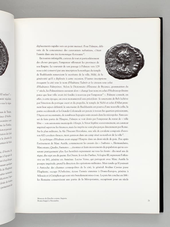
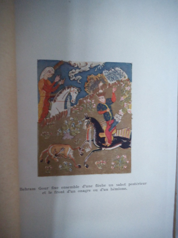
Title: Jauf and the North Arabian Desert. Author: H. St. J. B. Philby Publisher: London: Edward Stanford, Royal Geographical Society, 1923. Item is in Original Condition, with Blue Wrappers - As Issued, Complete with All the Ads! Notes & Condition: Philby recounts a journey made in 1922 together with railway engineer Major Holt, through Jordan to Jauf [Al Jawf Region, Al-Jouf] and into Iraq as far as Karbala, for the purpose of investigating the area's unstable political situation, and to examine possibilities of building a railway in the Wadi Sirhan valley. Beginning with a fascinating summary of a most unstable government indeed, Philby describes an ongoing power struggle between two dynasties, inter-tribal raids, a slave governor being murdered, betrayals and quarrels over land, so forth. The pair travelled to Medina, to the volcanic lava field of Harrat al-Shamah where they found some Safaitic inscriptions on stone, then to Sakaka where they stayed for nine days, and eventually arriving at the Al-Ukhaidir Fortress and the city of Karbala [Iraq], to be hosted by the Arab governor. Choosing a safe route was imperative as rebel holdings were prolific, particularly in the Al-Jawf Region. Once their mission was accomplished they made their way north for Ramadi, from where a flight would take them back to Amman. Interesting accounts describe inhospitable places and encounters, most notably the house of Sha'lan whose members were able to impede the expedition for some time. Philby's observations further include the important village of Kaf and its citizens, the Quraiyat salt -pans which are worked by the Badawin [Bedouins]; the plain of Ithra and its settlement of the black tents of the Ruwalla; the vast, dazzling, white salt marsh of Nuqrat al Hadhaudha, the prominent landmark of Kharana; Shaib Shanmari and in Jauf itself, the great medieval Arab fortress of Qasr Marid, the ruins of the hamlets of Suq and Suq al Hattab, the Safaitic inscriptions at Harrat; at the Sultan's invitation, a visit to Sakaka; the oasis of Qara; Suluba; the wells of Abal Dufuf; the magnificent ruins of Ukhaidir; Abu Dibis and Amadi. Photographic plates provide excellent visuals from the journey. Philby's account is accompanied by a large highly detailed fold-out colour map and a report by Major A. L. Holt titled, "The Future of the North Arabian Desert," which outlines his work in terms of developing communications through the desert, and a compelling argument promoting the desert as an important trade route. Holt accompanied Philby on his extraordinary Arabian adventure. At the time of this expedition, Philby was chief head of the Secret Service in Mandatory Palestine (since November 1921), working with T. E. Lawrence and meeting his American counterpart, Allen Dulles. 8vo. Two reports, 39 pages combined, plus a large fold-out colour map measuring approximately 59 x 34 cm, and photographic plates for illustration. Original condition with blue wrappers, titles to front, and containing all the ads. This is a complete issue, seldom found in such good and original condition. Excerpt from the text: "We left Amman on 10 March 1922... my personal preference... camels over mechanical transport in the real desert... in country where no organized route exists" "... The introduction of modern firearms has been a curse and veritable scourge to Arabia and its independent, individualistic denizens... the Arab social code of raid and rapine has not shown any signs as of yet of adjusting itself..." "... the northern desert of Arabia is at the present moment unsafe in the widest sense of the term - unsafe for the innocent traveller, the merchant, and the shepherd - there are already signs of a welcome change in the south, where Ibn Sa'ud has created a well-knit polity on a religious basis and has found himself strong enough to prohibit tribal raiding within his borders." "Our reception by the authorities of Kaf was cordial enough though guarded.... We were not allowed to visit the natural fortress ... called Qasr Sa'idi... a small guard of some twenty-five men with machine guns... Kaf is commanded by this eminence..." "... within a month of our sojourn at Jauf, we heard of the downfall of the house of Sha'lan at the hands of Ibn Sa'ud. As rulers they were detested by their own people, whom they treated with insolent harshness..." "Every human seen in the desert is an enemy, and the weaker party must make its best speed away if it would escape death." End Excerpt. Harry St John Bridger Philby, Order of the Indian Empire (CIE) (1885-1960), also known as Jack Philby or Sheikh Abdullah, was a British Arabist, explorer, writer, colonial office intelligence officer, and adviser to the first monarch of Saudi Arabia. Philby joined the British Foreign Service in 1917 and was the first European to visit the southern desert of Arabia. He was the first European to enter Abha, the capital of Najran, the frontier district between the Wahhabis and the Yemenites, and the second to visit Shabwa, although he was the first to explore the ruins where he discovered the great temple of Astarte. During Philby's explorations of Arabia, he came into contact with Ibn Saud, and was greatly influenced by the Wahabi ideology and culture, converting to Islam and renouncing his faith in Christianity.
Notes & Condition: Philby, a famed Arabian explorer and father of master spy Kim Philby, renounced British policy, became a Moslem, and joined the Wahabis. This expedition report Predates Philby's Book, entitled, Sheba's Daughters, Being a Record of Travel in Southern Arabia, With an Appendix on the Rock Inscriptions by A.F.L.Beeston, First Published in 1939. The account of a journey made by the author, Ibn Saud’s official adviser, from the King’s camp on the Mecca to Riyadh road to the Indian Ocean. Philby was the first European to enter Abha, the capital of Najran, the frontier district between the Wahhabis and the Yemenites, and the second to visit Shabwa, although he was the first to explore the ruins where he discovered the great temple of Astarte. An excellent account of Philby's travels in southern Arabia, particularly the Hadhramaut in 1936. The longest of Philby's journeys, ostensibly to map the new frontier with Yemen. Until the 1930's the highlands of south-west corner of Arabia were among the world's few remaining lands not fully explored or charted. Into that region Philby, author and explorer, made two journeys, the first in 1932, and the second in 1936 and 1937. This important Arabian Expedition is an account of exploration, containing valuable material on the Yemeni-Saudi borders, and excellent quality photographs taken for the first time in that area by a European. This narrative was published within two complete monthly issues, July and August, of the Geographical Journal.This is August issue only, 26 pages, plus black and white photographic plates and a large fold-out colour map measuring approximately 14 x 24 inches (35 x 61cm). This issue is in original condition with blue wrappers, titles to front, and containing all the ad, seldom found in such good and original condition.
16 pages, including a full-pages sketch map. Plus photographic plates. Original condition with blue wrappers, titles to front, and containing all the ads. This is a complete issue, seldom found in such good and original condition. In this fascinating report the author discusses the demarcation of the Turco-Persian Boundary and the three main efforts to settle it, which had each been interrupted by a great European war. Illustrations include the Karun, Kushk-I-Basri, North of Mohammerah, Proceeding to the First Boundary Pillar up River from Mohammerah, Crossing the Karha at Kut Saivid Ali, Commission searching for the Shatt Al Ama, Bakuba on the Diyala, Kurds and survey Khalassis, Commission crossing the Zab and Caravan on the March in the Tavila District.
50 pages, in two consecutive issues as published. Plus photographic illustrations, and a fold-out color map measuring approximately 9 x 7.5 inches (23 x 19cm). Original condition with blue wrappers, titles to front, and containing all the ads. Two complete issues, seldom found in such good and original condition. The famous author's groundbreaking explorations between Upper Swat and the Indus in 1926 are passionately recounted by him in this preliminary report. During the archaeological tour of Graeco-Buddhist remains in Swat (now in the far north of Pakistan), Stein located Alexander's trail and traced it to Pir Sar at a bend in the Indus. Stein's main object was indeed to personally follow the track of Alexander the Great in the region, as far as it was accessible outside of Afghanistan. Prior to the discussion of the exploits described in this work, this region was beyond the administrative border of the Indian North-West Frontier, and was inaccessible to Europeans. This is the first major Western account of these areas. Stein's account pre-dates his important book by two years, "On Alexander's Track to the Indus. Personal Narrative of Explorations on the North-West Frontier of India," first published in 1929. Aurel Stein's surveys were inspired by archaeological and historical interests, and his fascination with the cultures of Cental Asia. Trained as an Orientalist and archaeologist, he planned several expeditions to the interior of Asia and used Sanskrit, Persian, Chinese, Turkish, Greek and Latin as scholarly tools to unlock the geographical puzzles, in the process making valuable topographical surveys and penned down his experiences in his famous books. The routes and battlefields of Alexander’s campaign in the east had been a long-standing interest of Stein’s and whilst surveying for the Indian Government on the North-West frontier he was able to indulge his fascination. (Yakushi S336).
8vo. Two reports together in one issue, 23 pages combined, plus sketch illustrations, one which is a fold-out and a fold-out colour map, measuring approximately 13 x 14 inches (33 x 36cm). Original condition with blue wrappers, titles to front, and containing all the ads. This is a complete issue, seldom found in such good and original condition. Dealing specifically with the construction of a railway from Sukkur in today's Pakistan to Kandahar in Afghanistan, in the late 1870s during "The Great Game", Sir Temple gives an explicit account of the progress of construction, and of the geography, illustrating the region with sketches which were prepared on the spot by Lieutenant Goerge Temple of the British Navy. The immense undertaking is further illustrated with a striking colour fold-out map showing railways constructed and in operation, and other tracts proposed. Consisting of the important Bolan Pass railway, and the Sindh-Peshin railway where the Harnai line and the Quetta loop line meet, the tracks were forged through low range hills, an arid desert, the Pishinaleey of Pishin, and the Bolan Pass of the Toba Kakar Range in Balochistan - a pass which has always occupied an important place in the history of British campaigns in Afghanistan. Captain R. Beavan was Assistant-Superintendent of the Survey of India, and presents in his account a scientific assessment of the rivers, desert regions and valleys in Afghanistan, between Kandahar and Girishk, the latter being 75 miles northwest and originally built around a fort which was twice taken and abandoned by British forces.
36 pages. With a full-page sketch map and photographic plates.Does not have the map whic hwas published at alater date (the following year). Original condition with blue wrappers, titles to front, and containing all the ads. A complete issue, seldom found in such good and original condition. Wilfred Thesiger is perhaps the last, and certainly one of the greatest of the British travellers among the Arabs, his narrative is vividly written. These papers cover the five years in which Thesiger spent in and around the Empty Quarter, the half million square miles of one of the cruellest deserts in the world. The 20th century was very fortunate in being able to have a record of some of the glory it lost as seen through the eyes and camera of this very remarkable explorer. He was born in the British Legation in Addis Ababa in 1910, an event that was to shape the life of this extraordinary man and spent his first nine years in Ethiopia, or Abyssinia as it was then called. By the time he accompanied his parents back to England in 1919, the sight, sounds, wildness and raw savagery of the land had been instilled in him and a traveller was born. His return to Ethiopia in 1930 for the crowning of HIM Haile Selassie marked the beginning of his first hunting and exploration adventures into this highly dangerous country. Wilfred Thesiger has an immense ability to describe very vividly the life and ways of the people of the desert, the Bedu, and his work shines with his clear attachment to them. After leaving Arabia he travelled extensively in the Karakoram and the Hindu Kush (the setting of his meeting with Eric Newby immortalised in Newby's A Short Walk in the Hindu Kush), the mountains of Kurdistan and the marshlands of Iraq. But he says that none of these places moved him as did the deserts of Arabia. He spent five years in the region travelling on camels and on foot across some ten thousand miles of a vast empty land. What he found, as in his time with the people of the Iraq marshes which he described in his book The Marsh Arabs, was a way on life on the threshold of destruction.
20 pages. Plus a fold-out colour map, measuring approximately 10.5 x 8 inches (27 x 20cm). Original condition with blue wrappers, titles to front, and containing all the ads. This is a complete issue, seldom found in such good and original condition. This is a most compelling report on an English political mission determined to establish military consulates in Asia Minor to watch the introduction of reforms under the Anglo - Turkish Convention. This mission was primarily installed in order to glean information. A fascinating read accompanied by a map of Asia Minor (Anatolia) and showing the Gulf of Scanderun. A fascinating geographical report on the picturesque valleys, mountain districts, large rivers, ruins and new discoveries in Asia Minor.
25 pages, including a full-page sketch map. Plus black and white plates. Original condition with blue wrappers, titles to front, and containing all the ads. This is a complete issue, seldom found in such good and original condition. This is a fascinating and comprehensive historical report on the Persian Gulf, illustrated with black and white plates and a sketch map and dealing with the early records of commerce dating back to 2000 BC, the important sheltered port of Sur, Albuquerque's control over the Portuguese, and much more. This report being a preface to his book published the following year, Wilson gives us a compelling geographical and historical overview of civilian life, Bahrain and the pearling industry, the Islam religion, and Christain missions, in a time of British presence and much change in Iraq. The author spent almost 18 years in the Persian Gulf and was one of the most important British civil servants in the Middle East. He served in consulates at Ahwaz and Khorramshahr from 1907-1914 and also worked for the Anglo Persian Oil Company. He has been described as a versatile, fearless and exceptionally gifted man who was at home in all walks of life, and in all circumstances. In January 1919, the British set up a military administration under Sir Arnold Wilson, and in April 1920 the League of Nations confirmed the British Mandate over the region. Wilson's rule, however, helped set the stage for Great Arab Revolt in 1920. Because of the major economic investments, British war-time policy in Iraq was very different from western Arabia where they overtly encouraged and aided the Arab Revolt. The British managed to suppress the revolt at great expense. Wilson was later replaced by Sir Percy Cox who was sympathetic to Arab aspirations. On the outbreak of the Second World War Sir Arnold Wilson (who had served in parliament as MP for Hitchin since 1933) joined the Royal Air Force Volunteer Reserve. An air gunner in Bomber Command, he was killed in action over northern France in 1940 shortly before publication of his second book, S. W Persia: Letters and Diary of a Young Political Officer 1907-1914 (1941). This report pre-dates Wilson's book published in 1928, entitled The Persian Gulf: An Historical Sketch from the earliest Times to the Beginning of the Twentieth Century. A most incredible report on the ancient commerce of Persia, that shaped to a large extent the state of affairs in the turmultuous regions of the Middle East.
Light wear to DJ extremities with laminate peeling; Lavishly illustrated with numerous fold-outs. Photogravures; The Arts of Mankind; B&W and Color Illustrations; 4to 11" - 13" tall; 401 pages
New New Turkish Original bdg. Dust wrapper. 4to. (33 x 25 cm). In Turkish. 461 p., color ills. Kutsal mekanlarda kutsanmis örtüler. Topkapi Sarayi'ndan örneklerle Kâbe örtüleri.