STONE, DAVID J,SPERRY, RICHARD J,JOHNSON, JOEL O,SPIEKERMANN, BURKHARD F,YEMEN, TERRENCE A,Biblio.com

33 résultats
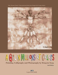
1996USD_9780815181453Mosby 1996. 2nd. Unknown Binding. UsedLikeNew/UsedLikeNew. Mosby unknown
1996AME_9780815181453Mosby 1996. 2nd. Unknown Binding. New/New. Mosby unknown
B9781732845954Paperback / softback. New. paperback
B9781951364076Paperback / softback. New. paperback
B9781951364052Paperback / softback. New. paperback
B9781732845916Paperback / softback. New. paperback
43437629like new. unknown
40728514like new. unknown
1951364074.Gpaperback. Good. Access codes and supplements are not guaranteed with used items. May be an ex-library book. paperback
1951364058.Gpaperback. Good. Access codes and supplements are not guaranteed with used items. May be an ex-library book. paperback
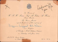
51-6973London: June 1953. 13.4 x 18.4 cm. Card stock with gilt embossing.Annotated in ink: Refused per P/a. This image could have imperfections as it’s either historical or reportage."May 07 1953 - Here for the Coronation: Prince and Princess Himalaya have arrived in London to attend the coronation from their home in the Everest country of Nepal.This is the Prince's first trip to Europe. Photo shows Prince and Princes Himalaya ".The personal copy of Begum Ra’ana Liaquat Ali Khan 1905–1990 who was a Pakistani diplomat and the country’s first female governor.She was born Sheila Irene Pant on 13 February 1905 in Almora British India today’s India to a Brahmin family who had converted to Christianity two generations prior.Academically brilliant she graduated from the University of Lucknow in 1927 with bachelor’s degrees in economics and theology. She obtained a double master’s degree in economics and sociology in 1929. In 1931 she became professor of economics at Indraprastha College in Delhi where she met her future husband lawyer Liaquat Ali Khan when he visited to deliver a lecture on law.The couple married in 1932 despite her family’s objection. The bride converted to Islam and took the name Begum Ra’ana. She became involved with the Muslim League devoting herself to creating political consciousness among the Muslim women in British India.After the Partition in 1947 Liaquat Ali Khan became Pakistan’s first prime minister. As the first First Lady of Pakistan Begum Ra’ana founded or helped establish organisations that uplifted women’s rights and women’s public role such as the Pakistan Women’s National Guard PWNG the Women’s Naval Reserves and All Pakistan Women’s Association APWA. London: June 1953 unknown
1997271959Paris: Flammarion 1997. hardcover. near fine/very good. Extensively illustrated with color photographs. 239 pages with text in French. 4to gray boards d.w.; minor edgewear and fading to top margin of dust wrapper. Paris: Flammarion 1997. A near fine copy in a very good dust wrapper.<br/> <br/> Instiut du Monde Arab<br/> <br/> Flammarion unknown
1732845913.Gpaperback. Good. Access codes and supplements are not guaranteed with used items. May be an ex-library book. paperback
2006BN7978Kasparek 2006. 2006. Softcover. Jemen Das HarazgebirgeNatur - Kultur - Trekking. Wandern in einer wunderschönen Terrassenlandschaft zwischen Wehrdörfern im Bergjemen <br/><br/>Jemen Das HarazgebirgeNatur - Kultur - Trekking. Wandern in einer wunderschönen Terrassenlandschaft zwischen Wehrdörfern im Bergjemen Kasparek paperback
0071586873.Gpaperback. Good. Access codes and supplements are not guaranteed with used items. May be an ex-library book. paperback
a76526Washington 1976 Defense Mapping Agency. Oblong 4to. 204pp. original printed wraps. Light non-circulating library marks no spine numbers no pocket no bookplate. VG. . paperback
0333353250.Ghardcover. Good. Access codes and supplements are not guaranteed with used items. May be an ex-library book. hardcover
1994BN100253Mainz am Rhein : von Zabern 1994. 1994. Les fortifications d'Arabie méridionale du 7e au 1er siècle avant notre ère. par. Deutsches Archäologisches Institut Sana / Archäologische Berichte aus dem Yemen ; BD 8 1.80 <br/><br/>Les fortifications d'Arabie méridionale du 7e au 1er siècle avant notre ère. par. Deutsches Archäologisches Institut Sana / Archäologische Berichte aus dem Yemen ; BD 8 1.80 Mainz am Rhein : von Zabern unknown
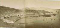
60392c. 1880s. . Panorama two albumen prints pasted on original card 20 x 50 cm title in negative. Good tonal range and in good condition.<br /> <br /> [c. 1880s]. unknown
1930182334London: Geographical Section General Staff War Office 1930. Later impression overprinted with a Cassini grid in 1930 following the first edition of 1926. This map of the Aden Protectorate and its neighbours was produced for the International Map of the World a project that aimed to create a complete world map at a 1:1000000 scale. It covers South Yemen and the Hadhramaut as well as the tip of French Somaliland. The International Map of the World or the Millionth Map of the World was first proposed by German geographer Albrecht Penck in 1891. The project was adopted by ten countries in 1909 who agreed to follow consistent rules and standards for mapping their own territories. While countries like the US and UK made strides at first "production was slow in the earlier years since it was first necessary to complete basic surveys for the required data and during and after World War II there was little interest in pursuing the project" Ency. Brit. Colour lithograph map 648 x 856 mm linen-backed perhaps not as issued key printed on recto; text in English and French. A little foxed dust-soiling slight wear and a few small holes along fold lines: a very good copy. unknown
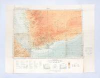
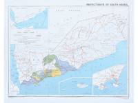
1964182178Surrey: Directorate of Overseas Surveys 1964. Later edition printed in the second year of the protectorate. In addition to showing the states of Kathiri Mahra and Qu'aiti it also highlights the members of the Federation of South Arabia in colour and features three inset maps which show the entire region the island of Socotra and the State of Aden. The Directorate of Overseas Surveys was established in 1946 with responsibility for surveying parts of the British Empire that did not have the resources to otherwise map themselves. "The Directorate was charged with two key tasks. It was to provide national geodetic frameworks throughout the British Empire that would contribute to understanding the size and shape of the earth and constitute the basis for accurate mapping. It would also produce mapping using modern methods based on aerial photography. This would in turn help to inform the development and administration of each country" Natural Collection of Aerial Photography. This copy is the fourth edition. Colour map 324 x 406 mm printed on recto only key on recto. Map bright a little bowed sometime folded with a vertical crease at centre slightly creased at edges: a very good copy. National Collection of Aerial Photography "Directorate of Overseas Surveys". unknown
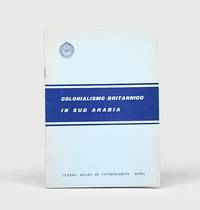
1962164052Rome: Centro arabo di informazioni 1962. First edition first printing scarce of this booklet published by the League of Arab States's communications body in Italy. The three maps show de facto and indefinite boundaries on the Arabian Peninsula in Aden and in Muscat and Oman. We have traced four institutional copies all of which are in Italy. The text surveys British activity in the region from the early 19th century through to the present day with sections on the Ottoman empire the First World War the 1934 peace treaty and the structure of the Aden Colony and Protectorates. Octavo. With 3 folding maps. Original card wrappers wire-stitched as issued front cover lettered in blue. Wrappers lightly toned and foxed contents clean with just couple of spots. A near-fine copy. unknown
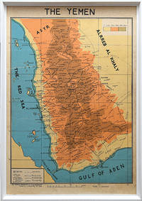
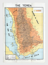
1976168409San a: Yemen Arab Republic Government 5 January 1976. Second edition labelled here as "The Yemen". It is drawn by the elusive cartographer usayn Abd All h Dham r here appearing as H. Althamary who also produced a map of San a . We have identified only six institutional copies on WorldCat at Exeter Leiden NLS Cornell LoC US Geological Survey. The first edition was published in Egypt in 1972 while an Arabic edition appeared in 1976. The map is in idiosyncratic English and marks the strategically important governorates of Taiz al-Bayda and Ma rib. Several words are misspelled including "drawen" "boundries" and "vally." The eastern border is left blank excluding the independent People's Democratic Republic of Yemen. A brief border war took place in October 1972 ending with the Cairo Agreement which proposed unification of the two Yemeni states. Each was backed by opposing Cold War powers: Saudi Arabia supported the Yemen Arab Republic while the Soviet Union backed the other. The two states ultimately united in 1990 as the Republic of Yemen. Colour lithographed map 655 x 450 mm scale 1:1000000; later laid down on board; white wooden frame overall 690 x 490 mm; text in English. Slightly toned some creasing one small hole: a very good copy. Warren P. Aston "The Origins of the Nihm Tribe of Yemen: A Window into Arabia's Past" in Journal of Arabian Studies: Arabia the Gulf and the Red Sea 4:1 2014 pp. 134-148. unknown
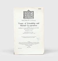
1934164042London: His Majesty's Stationery Office 1934. First English-Arabic edition first impression of the diplomatic agreement which acknowledged "the complete and absolute independence of His Majesty the King of the Yemen the Imam and his kingdom in all affairs of whatsoever kind" p. 2. In June 1934 shortly after this agreement was concluded Ibn Saud and Imam Yahya signed the Treaty of Taif which brought an end to armed hostilities between the two countries. In this development Britain had played a major part with its support for Yemen and comparatively lukewarm stance vis-à-vis Ibn Saud helping to both precipitate military conflict and ultimately bring it to an end. The English text of the treaty without the ratifications was first published earlier in the year as HMSO Yemen No. 1. Octavo 232 x 151 mm pp. 11. Royal coat of arms of the UK on first page. Sometime disbound with no subsequent stitching. Small faint Admiralty ink stamp dated 14 December 1934 on first page. Light creasing and skinning where previously bound a few nicks small chip at foot of first leaf text bright. A very good copy. unknown
178175Egypt: M. Louts 5 January 1972. With manuscript route annotations First edition here labelled "The Yemen". It is drawn by the elusive cartographer usayn Abd All h Dham r appearing as H. Althamary who also produced a map of San a . Only three institutional copies are recorded in WorldCat at Leiden the Library of Congress and Michigan. An Arabic edition and a second English edition were published in 1976. The map is in idiosyncratic English and marks the strategically important governorates of Taiz al-Bayda and Ma rib. Several words are misspelled including "drawen" "boundries" and "vally." The eastern border is left blank excluding the independent People's Democratic Republic of Yemen. A brief border war took place in October 1972 ending with the Cairo Agreement which proposed unification of the two Yemeni states. Each was backed by opposing Cold War powers: Saudi Arabia supported the Yemen Arab Republic while the Soviet Union backed the other. The two states ultimately united in 1990 as the Republic of Yemen. The route annotations in red pen stretch from Najran in the north to the Bab al-Mandab Strait in the south. Colour map 660 x 463 mm scale 1:1000000 text in English. Old fold marks a few small holes at folds small chip to head not affecting text a little offsetting at lower margin: a very good copy. Warren P. Aston "The Origins of the Nihm Tribe of Yemen: A Window into Arabia's Past" in Journal of Arabian Studies: Arabia the Gulf and the Red Sea 4:1 2014 pp. 134-148. unknown