3 550 résultats
1857ABC_46672HMS Cyclops:: Oman Khuriya Muriya Islands Yemen Egypt Red Sea Arabian Sea Pakistan Sri Lanka and other places 1857. Contemporary brown cloth over boards rebacked in period-style black calf with the spine lettered in gold: "Log H.M.S. Cyclops". Folio 20 x 31.5 cm. Over 360 pp. of manuscript entries written with brown ink in a legible hand on watermarked laid paper with a blue cast. With 8 pen and ink nautical charts and 5 sketches of coastal sites including the city of Muscat 8 on the logbook pages and 5 on separate thick album leaves. Historically significant manuscript logbook containing a detailed record of the first attempt to lay a submarine telegraph cable to connect London with British India. The expedition took place from May 1859 the Red Sea leg from Suez to Aden to February 1860 from Aden to the Khuriya-Muriya Islands Muscat and Karachi. The two specially designed cable ships the Imperador and Imperatrix were supported by HMS Cyclops which surveyed the coastlines and reported on the depth and structure of the ocean floor.The entries from February 1859 to May 1860 documenting the ship's Red Sea and Arabian Sea mission span over 200 pages. We first find the Cyclops near Cape Ras al Hadd on the eastern coast of Oman at the entrance to the Gulf of Oman: "Cape Ras al Hadd . terminates in a low sandy spit at the head of which is a village and mud fort. There is an inlet about 4 miles to the northward of the cape but inaccessible to large vessels. There is a heavy surf on the beach during northerly winds" 9 February 1859. The ship then plied in the Red and Arabian Seas between Egypt Yemen and Oman eventually finishing in Bombay.During its expedition the Cyclops visited and moored in Quseer and Zabardag Island Egypt Suakin Sudan Perim Island Strait Bab-el-Mandeb Yemen the Hanish Islands Yemen Palinurus Shoal and Cape Fartak Yemen al-Hallaniyah and al-Qibliyah Khuriya Muriya Islands Oman Ras Madrakah and Ras al Hadd Oman Charna Island and Karachi Pakistan. The logbook entries record the soundings and the laying of cable along with quotidian ship activity. Brief entries touch on the death of crew members; discharging coal; punishing men for wrongdoing; maintenance of the ship; other ships in company; visits on board by local notables etc. Six larger entries occupying up to two pages of text describe the topography landmarks soundings and economy of Karachi Zabargad Island and Muscat Cove this last harbour said to be "formed by Muscat Island on the east and Ras Muscat on the West it is one mile deep by half a mile wide with 12 fathoms at entrance decreasing to 3 fathoms ahead of the town. It is defended by two . batteries on the island one on the height to the seat of town and two on Ras Muscat. They are all in a stay ! - or: state of decay. The entrance to the cove is difficult to make out when coming from the eastward . The exports of Muscat are wheat dried fish dates and cattle the imports being European and Indian manufactured goods sugar etc. The revenue is about £100000. The Imaum's Palace faces the water his army generally consists of from 10 to 12000 men and the fleet of 2 frigates 2 corvettes a transport and brig the greater part of the Navy having been removed to Zanzibar the Captains of these vessels being educated at Bombay or Calcutta. Supplies of all kind are cheap and plentiful. Boats may be hired thro' the medium of the Agent of the Indian Government for the shipment of coals" 26 November 1859.Illustrated with eight well-executed pen and ink nautical charts showing the routes of the Cyclops in the Red and Arabian Seas as well as the harbours of Muscat Cove and other places. Five beautiful ink sketches show the city of Muscat "Hallani Bluff from Addington Cove" al-Hallaniyah the largest of the Khuriya Muriya Islands Oman Ras Fartak Yemen Karachi harbour and Colombo.The cable too lightly armoured and laid with too little slack soon failed: indeed the 1859 section had already broken down by the time the route was completed in 1860. Messages were passed over individual sections but the entire cable never worked as a unit. Communication to India would not be established until the 1864 Persian Gulf cable was laid. The captain of the Cyclops the noted British navigator and Arctic explorer William Pullen 1813-87 took part in the unsuccessful 1849 attempt to rescue Sir John Franklin's disastrous expedition in search of a northwest passage then in the same year became the first European to sail along the north coast of Alaska in his voyage from the Bering Strait to the Mackenzie River in Canada.A final part of the log comprising some additional 150 pp. May 1860-May 1861 covers the Cyclops's survey of the southeast coast of Ceylon and her return voyage to England. Overall an important content-rich source on the early history of the submarine telegraph cable around the Arabian Peninsula to British India.In good condition. Oman, Khuriya Muriya Islands, Yemen, Egypt, Red Sea, Arabian Sea, Pakistan, Sri Lanka and other places, hardcover
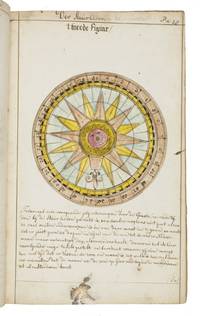
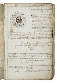
1735LC4E9Q4RAGZBHolland 1735. Green paper wrappers made from a discarded prospectus or the wrapper of an instalment of a book ca. 1865 sewn at 6 stations some perhaps without supports later green cloth spine with the title in manuscript on the front wrapper. Folio 31.5 x 20.5 cm. A manuscript course in navigation written in brown ink on laid paper in a largely upright cursive hand with 6 colour figures including 2 volvelles about 100 black and white diagrams and numerous tables of data highlighted with a yellow wash. A detailed manuscript course in the art of navigation in folio format with figures in colour including two volvelles partly based on the very rare first edition in 8vo format of Klaas de Vries 1662-1730 Schat-kamer ofte konst der stier-lieden 1702; Crone 374 probably in the first issue not known to survive before the insertion of an additional quire between B and C. But the manuscript doesn't merely copy the printed book: at least much of the text differs and also at least some of the tabular data and some of the figures also have no direct equivalents in the printed book also not in later editions as far as we have seen. The colour illustrations include a compass rose 13.8 cm diameter with a ship in the centre directly copied from the folding engraved plate in De Vries and virtually the same size but the ship in the centre is copied in mirror image and De Vries's abstract floral decorations in the corners outside the circle are replaced by colour drawings of four different flowers one in each corner. The manuscript also directly copies De Vries's woodcut illustration of a human hand marked with the numbers "29" "9" and "19" on the thumb and the letters A B and C next to them presented as an aid to calculating the epact the number of days past the new moon on 1 January but the hand is rotated 180 degrees. Most of the examples of calculations use years in the period 1700-1711 though there are a few later ones one example uses the year 1809! which also largely agrees with the 1702 edition of De Vries though the examples are not identical. The clearest indication that the present manuscript follows the 1702 edition rather than a later one is that the tables giving differences between the positions of the sun and moon cover the years 1701-1704 as in the first edition before the insertion of an extra quire extending the tables to 1710 B8 was replaced at the same time not noted by Crone. All later editions we have seen give these tables and the examples of calculations for later years. Yet even in these tables the data in the present manuscript doesn't exactly agree with De Vries's. With a bookseller's ticket ca. 1901/1919. Very slightly browned with occasional minor spots or ink stains but still in good condition. The one leaf that appears to be lacking may have been deliberately cancelled by the compiler. The wrapper has a later cloth spine as noted and is somewhat worn. A fascinating manuscript course in navigation with volvelles and other figures in colour partly based on the very rare first 1702 edition of De Vries's handbook but not merely copying it.l For De Vries's 1702 handbook: Crone 374 collation not entirely correct. hardcover
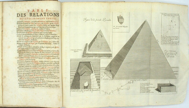
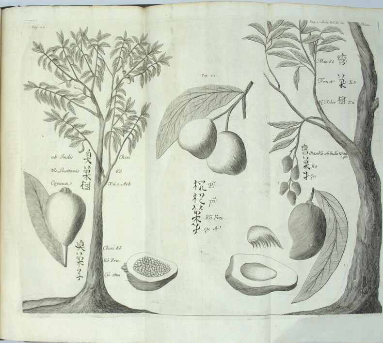
1696PHO-1981Paris, Thomas Moette, 1696 ; 5 parties en 2 vol. in-folio (37x23,5cm), veau marbré, dos à nerfs richement orné de motifs dorés avec tomaison et pièce de titre grenat, quelques frottements, charnières fendillées, manque au dos, coins usés, coiffes absentes, 8 feuillets détachés, rousseurs, qlqs feuillets brunis. L’illustration comporte de nombreuses gravures et illustrations dans et hors texte, 6 cartes dont la carte de l’Indostan, de la Colchide, du Japon (qui regarde l’Amérique), carte de la route du voyage de Canton à Péking, carte de l’Éthiopie, carte de l'Éthiopie ["Entrée de quelques ports…"]. Il manque la Carte de Bassorah, les 2 planches de caractères Chaldéens, la carte de l’Australie, la carte des côtes d’Arabie et d’Asie, la carte des Costes de Sierlionne, la carte des Philippines et Chine, la carte de Chine
1783340504W. Strahan, J.F. And C Rivington, A. Hamilton etc., London 1786, 1779,1781 + 1783. mehr als 1000 Seiten je Band mit Titelkupfer in Band 1 und mit 145 (von 146) teils gefalteten Kupferstich-Tafeln sowie 78seitigem Index im Tafelband, (more than 1000 pages per volume with title copper in volume 1 and 145 (of 146) partly folded plates (copperplate engravings) and with 78-page index extensive index in the plate volume), 2° (40 x 24 cm), Originalganzledereinbände der Zeit mit Rückentitel, fachmänisch restauriert, Papier ganz vereinzelt leicht braunfleckig, Innendeckel mit Exlibris, insgesamt sehr gute Exemplare mit sauberen Tafeln, (Original all-leather bindings of the period with spine title, professionally restored, paper with occasional slight brown spots, overall very good copies with clean plates),
354239Au Dépôt Général De La Marine S.L. 1831 Grand in-folio ( 675 X 525 mm ), demi-toile bleue à coins, plats de percaline maroquinée. Exemplaire complet de son feuillet d'index gravé et de ses 32 cartes gravées -majoritairement marines- dont 8 sur double page ( dont carte générale de la Corse ) et montées sur onglet. EDITION ORIGINALE. Rousseurs passim et petite mouillure claire en marge intérieure. Bon exemplaire. TRES RARE. Cervoni, Image de la Corse, 138.
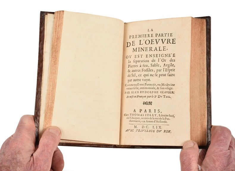
21548- Annotations sur l’appendix de la cinquiesme partie des “Fourneaux philosophiques”, où il est traitté de plusieurs secrets inconnus, et utiles. Mises en lumière, en faveur des incrédules et ignorans par Jean Rudolphe Glauber. Et traduites en françois par le Sr Du Teil. 62 pp., [1] f.bl. (Stanislas de Guaïta 1421-352)- L’Oeuvre minérale : La Première partie... ou est enseignée la séparation de l’or des pierres à feu, sable, argile, et autres fossiles, par l’esprit de sel, ce qui ne se peut faire par autre voye. Comme aussi une panacée, ou medecine universelle, antimoniale, et son usage. 64 pp.- L’Oeuvre minérale : La seconde partie... De la naissance et origine de tous les métaux et minéraux ; de quelle façon ils sont produits par les astres, sont composez d’eau et de terre, et reçoivent diverses formes. En faveur des curieux. 48 pp.- L’Oeuvre minérale : La troisième partie... ou commentaire sur le livre de Paracelse, appelé “le Ciel des Philosophes”, ou le livre des vexations, dans lequel sont enseignées les transmutations des métaux ; avec un appendix touchant la fonte, la séparation, et les autres opérations nécessaires. 111 pp., [1] bl.- La teinture de l’or ou le véritable or potable ; sa nature, et sa différence d’avec l’or potable, faux et sophistique. Sa préparation spargique et son usage dans la médecine. 22 pp., [1]f.bl. (Caillet 4588 - Stanislas de Guaïta 625)- Traité de la médecine universelle, ou le vray or potable. C’est à dire, une exacte description de la vraye médecine universelle, et de l’admirable vertu qu’elle exerce sur les végétaux, animaux et minéraux. Pour servir de clair flambeau au monde aveugle, luy enseignant le moyen de discerner le mensonge d’avec la vérité ; et de secourir les pauvres malades abandonnez. 61, [1] pp., [1] f.bl. (Stanislas de Guaïta 352 - Lenglet Du Fresnoy p.177)- La Consolation des navigants. Dans laquelle est enseigné à ceux qui voyagent sur mer un moyen de se garantir de la faim et de la soif, voire mesme des maladies qui leur pourraient survenir durant un long voyage. 64 pp. (E.O. trad. Caillet 4569 - Stanislas de Guaïta 352).
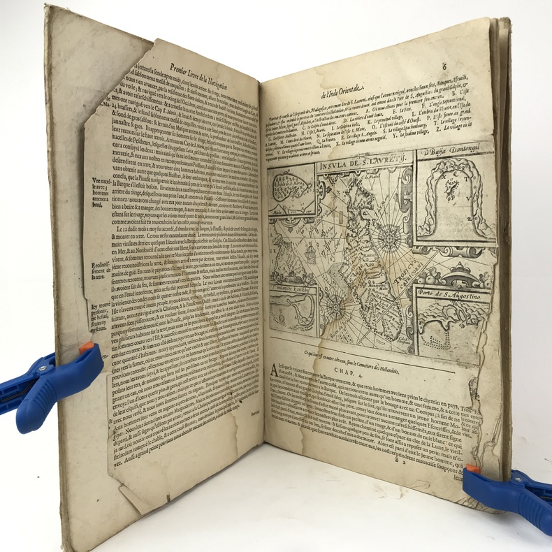
1609PHO-11431 volume in-folio (33 x 23 cm), vélin rigide parchemin (reliure de l'époque), dos lisse titré à l'encre, nombreuses écritures manuscrites sur les plats, 5 à 53-[1] feuillets. Page de titre, 3 premiers feuillets et feuillets 51 et 52 manquants, charnière fendue ,mouillure sur 5 ff et manque de papier en marge , galerie de vers avec manque. Seconde édition française, illustrée de 55 gravures sur bois in-texte.
1710ABC_46964The Netherlands 1710. Contemporary flexible paperboards. Folio 33.5 x 21.5 cm. With more than 300 mathematical figures and illustrations mainly full- half- and quarter-circle diagrams. The Dutch text is written in a clearly legible 18th-century cursive hand in brown ink. Early 18th-century Dutch manuscript on the art of navigation based on Klaas de Vries Schat-kamer ofte konst der stuurlieden . 1702. De Vries taught mathematics in Amsterdam his work proved very popular and appeared in numerous editions between 1702 and 1818. The author of the present manuscript unknown but was most likely a student of mathematics possibly even a student of De Vries himself at the beginning of the 18th century.The manuscript deals with several subjects regarding navigation including many different calculations for calendars for example the golden number the tides and determining the time at night. Furthermore theories and examples of correcting compass declination and determining the time of sunrise and sunset from the declination of the sun in combination with the pole star map reading and course calculation. It ends with approximately 50 sample problems in trigonometry and geometry showing the student author's mathematical work.Binding soiled edges frayed lacking the first 7 leaves quires 3 and 5 detached. With several ink stains the ink has bled through some leaves. Otherwise in good condition. An interesting manuscript on navigation probably from a Dutch student ca. 1702/13.l For De Vries's work: The Crone library 374 1st ed 1702. hardcover
1800PHO-1086Texte In-8 (200 x 130 mm) Relié demi-basane, dos orné pièce de titre et de tomaison ,T1 manque coiffe sup.,T2 ,manque coiffes, papier bruni. 440 pp et 332 pp suivi de 109 pp de vocabulaire et table des planches contenues dans l’atlas, table des chapitres du volume et errata. ATLAS Atlas pour servir à la relation du voyage à la recherche de La Pérouse, fait par ordre de l’Assemblée constituante, Pendant les années 1791, 1792, et pendant la 1ere et 2eme année de la République Française. Paris : H. J. Jansen, An VIII de la République (1800). — In-folio, 510 x 335 : titre, 1 carte, 43 planches. Demi toile , dos lisse avec titre , planches 6 détachée et 35 détachée et émargée , dédicace «à Mr V. Rey, secrétaire général de la Nouvelle Calédonie,1903»
1900176895Shanghai: Brewer & Co. c.1900. From the Chefoo Bluff to Lamtong Head Sole edition untraced institutionally the copy of Vice-Admiral Seymour's chief of staff in Tianjin during the Boxer Uprising. This photographic guide is designed for "the navigator of this changeable and frequently foggy locality" preface. We have traced only one other copy which appeared in commerce in 2017. Navigators in the late Qing period could rely on only a small network of lighthouses and fixed navigational aids when sailing the Chinese coast. "In thick weather even a person familiar with the coast is at a loss to identify a well-known Islands with its summit" preface. The thirty views include the Chefoo Bluff in the Pechili Gulf the waters near the Hieshans Light House Zhejiang and Hong Kong's Lamtong Head. A concerted period of lighthouse-building in the 1910s and 1920s obviated the need for further publications of this kind. Provenance: though unmarked as such this copy was owned by Captain Edward Henry Bayly C.B. 1849-1904 Commander of the International Forces at Tianjin in June 1900. Bayly had a lifelong career in the Royal Navy. He was promoted to the rank of lieutenant in September 1873 commander in June 1887 and captain in January 1894 having served overseas in numerous ships. Bayly captained HMS Pelorus during the fleet review for Queen Victoria's diamond jubilee in 1897 and in 1899 became captain of the armoured cruiser HMS Aurora on the China station. During the Boxer Uprising he replaced the wounded John Jellicoe as chief of staff to Seymour was mentioned by Seymour in dispatches and remained at Tianjin until the withdrawal of naval forces. He retired at his own request in February 1904. Landscape octavo. With 30 mounted collotypes within red frames. Original red cloth front cover lettered in gilt white coated endpapers leaves hinged with white linen as issued. A little shaken binding sunned and stained contents well preserved a little toning at fore edges: a very good copy. hardcover
1663PHO-2278A Paris, chez Jacques Langlois, 1663-1666 3 parties en 1 volumes in-folio (38x25cm). Veau tacheté époque, dos à nerfs ornés avec pièce de titre en maroquin et tomaison, tranches jaspées rouges. Réparations au dos et coins, mouillure, quelques rousseurs, réparation au titre, renforcement à la carte. Complet de ses relations de voyage selon Brunet & Camus
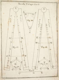
17533742NAPLES:: IGNAZIO RUSSO 1753. FIRST EDITION. Quarto:. 23.6 x 17 cm. 8 56 Collation: a4 A-G4. 15 engraved plates engraved by Filippo de Grado. Bound in contemporary vellum over boards. Foxing. Complete with the 15 engraved plates. Little is known of the author other than that he wrote another book on navigation in 1750. This work on the sector was translated into Spanish in 1758. By the time this book was published the design of the European sector had become standardized. Compare this design for example with that in the fourth edition of the works of Ozanam seventeen years earlier L’usage du compas de proportion 1736. The physical design of Pagnini’s instrument is better with pegs and decorative tenons to hold the two legs in alignment but the scales are essentially identical. The work is well illustrated with engravings showing exactly how a pair of dividers should be used to take the various lateral and transverse measurements. Pagnini provides eight tables that detail the exact markings for each scale. He also provides other material for reference use e.g. he includes not only a table for the construction of the line of metals but also one of their relative weights and their alchemical symbols etc. Tomash & Williams P7; Riccardi ii 236 IGNAZIO RUSSO, unknown books
1928174745Likely Shanghai: 1928-34. Mariners are warned to exercise due caution when approaching and when in the waterways A collection of otherwise untraced notices to mariners compiled by a civilian captain who plied the lower Yangtse during the late 1920s and early 1930s. Yangtse shipping was regulated by the Maritime Customs Service which issued around 100 navigational advisories per year. During the late 1920s shipping traffic on the Yangtse rebounded after several years of decline during the Warlord Era. Low water however continued to pose problems for navigators and increased the need for effective river management. The 39 notices are technical directions concerning specific parts of the channel. They specify when vessels may and may not enter stretches of water warning of the persistent presence of Chinese craft not subject to the same notices offer guidance for navigating buoyed channels provide optimum bearings and relay a change to the position of the Bend and Gravener Island beacons due to the erosion of the channel. The majority date from 1929. The identify of the "Captain Smith" referenced on the front cover has proved elusive but he may be the individual pictured in photograph Sw13-045 G. Warren Swire collection SOAS. Landscape octavo. Contemporary brown half cloth binder with metal clasp spine lettered in gilt buff paper sides front board with manuscript label "Captain Smith" boards lined with pink paper typescript list of charts on inner front cover 39 sheets each typed one side only in black or blue most duplicate typescript a few top copy. Boards lightly soiled clasp rusted sheets generally well preserved a few creased or with holes near clasp legibility unaffected typescript list with a few losses to text: a very good example. hardcover
1892184592Karachi: Published by the Chairman Karachi Port Trust 1892. Traced in only one institutional library First edition of this scarce guide for pilots and mariners with the tipped-in compliments slip of the secretary of the Karachi Port Trust addressed in manuscript to the Swedish shipping firm K. O. F. Dalman. The guide details the specifications of the harbour mooring charges pilotage and towage charges and the size of recent trade. The four appendices include a July 1892 notice to mariners a list of steamers to leave port in the preceding year a name list for the Karachi's chamber of commerce and foreign consuls and the text of a Sind Gazette article on a recent survey by the port engineer. WorldCat records a copy at the University of Western Australia. Octavo pp. 34. Tissue-guarded frontispiece 3 colour folding maps regional map extending from Tibet to Arabia; plan of Karachi harbour plan of suggested additional wharfage. Original blue cloth front cover lettered in gilt. Text block now loose in covers but in itself sturdy cloth with some staining and marking wharfage plan with small closed tear just crossing neatline: very good. hardcover
193742801London: Golden Cockerel Press 1937. Hardcover. Introduction and notes by Owen Rutter. Illustrations by Lynton Lamb. Complete 2-volume set. Tall 4to. Brown beige and green cloth with gilt spine lettering. 435pp 259pp. Four wood engravings two across each two-page title pages. Very good. Bindings a tad corner and edgeworn and rubbed though internally fine and tight. First of this edition a handsome set of this beautifully-produced pair by the legendary British fine press. Limited to 300 sets this #205. Scarce and lovely. Golden Cockerel Press hardcover books
1822PHO-2146Paris, Au Dépôt général de la Marine, 1822 et 1829. 2 volumes grands in-4 (34,5 × 27 cm), demi-maroquin à coins, dos lisses avec titres et tomaisons, guirlandes aux plats. Deux volumes de vues uniquement, toutes gravées et montées sur onglets. Premier volume : faux-titre, titre gravé illustré d’une Vue du Goulet de Brest, gravée par Schroeder, table des planches, et 91 vues à double page. Second volume : faux-titre, table des planches, 91 vues à double page, numérotées 79 à 169, et 20 planches de marées.
1780PHO-2387Paris, Hôtel de Thou, Laporte, Moutardier, 1780/1801, 32 volumes in-8, basane époque, guirlande sur les plats, dos ornés, pièces de titre rouge et pour les tomes 22 à 32 ; pièces de tomaison vertes, triples filets aux plats, tranches rouges, fleurons légèrement différents pour les tomes 22 et 23. Quelques accidents aux coiffes, quelques épidermures au supplément, légers manques de matières sur quelques tomes, mouillure très claire sur quelques feuillets (2 tomes), le tout sans gravité. Ex-libris du Comte de Farcy de la Villedubois au dos du premier plat. Belle édition de l’Abrégé de l’Histoire des Voyages, elle se compose des 21 premiers volumes de 1780 publiés par La Harpe à l’Hôtel de Thou, des 2 volumes publiés en 1786 consacrés au troisième voyage de Cook et formant les volumes 22 et 23, chez Laporte, et des 9 volumes de suppléments publiés entre 1798 et 1801 par Delpuech-Comeiras et imprimé chez Moutardier. L’illustration est formée de l'atlas complet des 74 (+1 en double) cartes dépliantes des diverses parties du monde, dont la Carte dépliante de l'hémisphère austral montrant les routes des navigateurs les plus célèbres par James Cook, une carte de Tahiti, d'autres du Kamtchatka, du Spitzberg, des îles Antilles, etc, et de 4 cartes pour les tomes 22 à32 ainsi que 101 planches dont certaines dépliantes, les cartes et gravures en très bel état.
17788670Paris, de l'Imprimerie Royale, 1778. 2 volumes in-4 de [4]-389-[1]-XIX-[3]; [8]-500-XXXII pages, plein veau marbré brun, dos à nerfs ornés de filets et fleurons dorés, pièces de titre en maroquin rouge, tranches mouchetées, petits accrocs aux coiffes supérieures, épidermures, coupes et coins frottés, tampon sur les pages de titre, quelques pâles rousseurs.
Very Good French Contemporary 1/4 leather bdg. with marbled boards. Small 4to. (27 x 19 cm). 23 p. (11 p. in Ottoman script (Old Turkish with Arabic letters; 12 p. in French), with rare 4 folded maps. A very good copy. First and only edition of this extremely rare bilingual book in French and Ottoman Turkish, including the first records on the formation and characteristics of storms to explain how storms and hurricanes occurred, which route they followed, and how they were conveyed to the regions that need to be warned by telegraph, for the vessels sailing in the seas, by French expert Coumbary who was founded the Rasathâne-i Âmîre [i.e. Ottoman Imperial Observatory]. Both the original French and Turkish translations of the work were published together in one volume. The work also included four maps which were drawn for this work only. The first map shows the movement of a storm that occurred on March 8, 1865, the second one shows the occurrence between the Tropic Cancer and Capricorn whirlwinds, storms in the Atlas and Indian oceans, the movements in the Bay of Bengal, the storms in different directions in the China Sea, the Gulfstream, Grönland, and Azores. The second observatory in the Ottoman era was established for meteorology. Before this center was established, beginning from the Reformation (1839), many meteorological observatories were built by foreigners in various cities such as Istanbul, Smyrna, Trebizond, Tekirdag, and Merzifon both as private and public establishments. The very first known temperature readings are the meteorological observations made by the Priest Dalmas at the St. Benôit monastery between 1839-1847. Later William Lane, an Englishman who came to Istanbul during the Crimean War, made observations at the British Cemetery at Haydarpasa. W. Noe, director of the Mekteb-i Fünûn-u Sahane made observations at the house in Kalyoncukulluk where he lived until the Beyoglu Fire in 1848; and finally, it is known that French engineer Ritter, who was invited by the government for waterworks in Kuruçesme (1856-1860) also conducted meteorological observations. Observations on precipitation and humidity conducted between 1875-1892 by an amateur observer on the Thomson Farm in Erenköy are invaluable on the subject of Istanbul's climate. These observations have been published in Budapest in 1928. Excellent observations on heat, pressure, and humidity, made in the summer residence of the Russian ambassador on Büyükada have also been published, in Annales St. Petersburg. In 1858, the French government established the first observatory communicating data over the telegraph, and in 1863, by compiling meteorological data in France, the French National Meteorological Network started operations. In 1868, upon the recommendation of the French government, the Rasathane-i Âmire was founded to convey meteorological forecasts to certain centers by telegraph. Instruments were purchased from leading European factories, and operations started on top of a hill 74 meters high on Pera. The first director was Mr. Aristide Coumbray, who came to Istanbul to renovate the telegraph network. (Instruments commissioned from France were set up at Mr. Coumbary's home, which stood at the garden of the Swedish Embassy. The observatory was later moved after its offices were prepared.) Coumbary represented Turkey in the first international meteorology congress, convened in Wien five years later in 1873. Rasathane-i Âmire worked by the same system as the National Meteorology Center in France. In the observation books of 1868 (August-November), names of affiliated stations are given to us Soulina, Köstence (Constantia), Varna, Burgaz, Valona, Elbasan, Durazzo, and Beirut. Later, stations in Izmir, Diyarbakir, Baghdad, and Fao were also added. The observatory founded by Aristide Coumbary in 1868 in Istanbul, operated until the end of the First World War. Özege 5735.; TBTK 7688, 10862.; Not in OCLC.
Very Good Turkish, Ottoman (1500-1928) Full leather new bdg. Original illustrated cover saved inside. Roy. 8vo. (24 x 17 cm). In Ottoman script (Old Turkish with Arabic letters). [12], 166, [2] p., b/w and color plates of Ottoman warships and scenes from naval wars, seven maps of the earliest examples of Ottoman cartography. Very rare second edition of this book on the history of Ottoman naval wars against Venetians began with the Crete campaign (War of Candia) in 1645 and lasted for years until 1656. The book was published first in 1729 in Müteferrika Printing House which was the first printing house in the Islamic world as the third printed book. This is the second edition including five maps of almost the same size (two paged) titled world map, The Mediterranean, The Archipelago (Aegean), The Adriatic Sea, and the compass-like in its first edition as well as two maps and twenty-six plates (some of them are color) and small illustrations of Ottoman ships as head of some carriage returns. Additional maps depict the city of Venice (from Kitab-i Bahriye [i.e. Book of Navigation) and the travels of Ottoman Admiral Sidi Ali Reis through the Sea of Oman. The Cretan War or the Fifth Ottoman-Venetian War, was a conflict between the Republic of Venice and her allies (chief among them the Knights of Malta, the Papal States, and France) against the Ottoman Empire and the Barbary States because it was largely fought over the island of Crete, Venice's largest and richest overseas possession. This account of Ottoman maritime warfare in Turkish, written in Safer 1067/November 1656. This date places the book in a moment of utmost danger for the Ottoman capital following the defeat of the Ottoman navy at the hands of the Venetians at the Dardanelles (4 Ramadan 1066/26 June 1656) and the subsequent loss of the islands of Lemnos and Tenedos. It is also written shortly after the appointment of Köprülü Mehmed Pasha as grand vizier (25 Dhulqada 1066/14 September 1656). Thus it is suggested to read it as a program of reform of the navy intended for a person whom Hadji Khalfa might have seen as the "man of the sword" who might revert the fate of the Empire. Of the four ulemâ [i.e. scholars] who wrote endorsements for the book, two are closely related to the Köprülü family. The first part is a history of Ottoman maritime campaigns from the beginning to 1067/1656, while the second is a systematic description of naval affairs, from administration and offices to shipbuilding, culminating in a list of 40 suggestions for the organization and strategy of the Ottoman navy, including the use of recent scientific and technological innovations. Thus the juxtaposition with history provides an argument for reform. Suggestions are largely centered around the traditional qanun-i qadim; there is no reference to high-board ships. The final pages include an important discussion of historical causality, explaining how divine omnipotence creates the consequence of historical causes, in reward for the righteous rule, or punishment of injustice. (Source: Ottomanhistorians). Özege 21273.
Very Good Turkish, Ottoman (1500-1928) Original handsome brown quarter leather binding with Ottoman lettered gilt to spine. Five raised bands to spine, separated from each other with lined gilt. Slight stains on the title page. Else a fine copy. Roy. 8vo. (23 x 16 cm). In Ottoman script (Old Turkish with Arabic letters). 99 p. Hegira: 1313 = Gregorian: 1895. Extremely rare first printed edition of this one of the earliest travel accounts, of an Ottoman admiral's early expeditions to the Indian Ocean, Arabian Sea, Red Sea, and Persian Gulf to counter Portuguese piracy and attacks on Muslim pilgrim ships, which describes the lands he has seen during his voyage from India to Constantinople by Sidi (Seydi) Ali Reis (1498-1563) sent by Sultan Suleiman the Magnificent covering the years 1553-1556. During these naval wars, after two marine battles against the Portuguese fleet and a great storm named The Elephant Typhoon (Tufan-i Fil) by the locals, Reis' remaining six galleys drifted to India. The fleet was unserviceable, resulting in his return home overland with 50 men. Reis then arrived at the royal court of the Mughal Emperor Humayun in Delhi, where he met the future Mughal emperor Akbar, who was twelve years old at the time. He returned to the Ottoman Land over Muslim states in South Asia; Afghanistan, Central Asia, and Iran. But he delayed his return because of the war between the Ottoman and the Safavid Empires in Iran. Finally, following the treaty of Amasya in 1555, he was able to return home and present his book of this narrative journey to the Sultan in 1557. This work offers an extensive insight into the Muslim situation in 16th century South and Central Asia and the Middle East, Islamic navigation, and Turkish - Portuguese relations as well as Persian, Afghan, and Indian geography, naval routes, flora, and fauna. Seydi Ali Reis, formerly also written Sidi Ali Reis and Sidi Ali Ben Hossein, was an Ottoman admiral and navigator. Known also as Katib-i Rumi, Galatali, or Sidi Ali Çelebi, he commanded the left wing of the Ottoman fleet at the naval Battle of Preveza in 1538. He was later promoted to the rank of fleet admiral of the Ottoman fleet in the Indian Ocean, and as such, encountered the Portuguese forces based in the Indian city of Goa on several occasions in 1554. Seydi was able to unite several Muslim countries on the coast of the Arabian Sea (such as the Makran Kingdom, Gujarat Sultanate, and Adal Sultanate) against the Portuguese. He is famous today for his books of travel such as the Mir'ât ül Memâlik [i.e. The Mirror of Countries], and his books of navigation and astronomy, such as the Mir'ât-i Kâinât (Mirror of the Universe) and the Kitâb ül Muhit: El Muhit fî Ilmi'l Eflâk ve'l Buhûr [i.e. Book of the Regional Seas and the Science of Astronomy and Navigation] which contain information on navigation techniques, methods of determining direction, calculating time, using the compass, information on stars, sun and moon calendars, wind and sea currents, as well as portolan information regarding the ports, harbours, coastal settlements and islands in the various regions of the Ottoman Empire. His books are translated into numerous languages including English, French, Italian, German, Greek, Arabic, Persian, Urdu, Russian, and Bengali, and are considered among the finest literary works dating from the Ottoman period. "When Sultan Suleiman had taken up his winter residence in Aleppo, I, the author of these pages, was appointed to the Admiralship of the Egyptian fleet and received instructions to fetch back to Egypt the ships (15 galleys), which some time ago had been sent to Basrah on the Persian Gulf. But, 'Man proposes, God disposes.' I was unable to carry out my mission, and as I realized the impossibility of returning by water, I resolved to go back to Turkey by the overland route, accompanied by a few tried and faithful Egyptian soldiers. I traveled through Gujarat, Hind, Sind, Balkh, Zabulistan, Bedakhshan, Khotlan, Turan, and Iran
17400056271740 S. l. n. e. [Amsterdam, Pierre Mortier], 1740. In-quarto (257 X 205 mm) veau fauve marbré, supra-libris (lettre « V ») doré au centre des plats, dos à nerfs orné, pièce de titre maroquin grenat, tranches rouges (Reliure de l'époque) ; portrait-frontispice, (2) ff. de faux-titre et titre, XL-284 pages, 6 planches hors-texte. Quelques feuillets uniformément brunis.
230478Paris, Hachette et cie, 1866 2 vol. in-12, 352 pp. et 376 pp., demi-basane brune, dos lisse orné de filets dorés (reliure de l'époque). Dos frotté avec épidermures. Chocs sur une coupe au tome I. Rousseurs.
17224938Paris, Étienne Ganeau, 1722. 1722 2 vol. in-12° (163 x 102 mm) de: I. [6] ff. (titre, préface, approbation, privilège); 378 pp.; [3] ff. (table); II. [4] ff. (titre, table); 316 pp. Plein veau granité dépoque, dos à nerfs orné, titres et tomaisons de maroquin rouge, filet à froid encadrant les plats, roulette dorée sur les coupes, tranches jaspées de rouge. (Rares rousseurs ou tâches).
226885Paris, A. Cadart, s.d. (vers 1875) in-4, titre et 40 planches gravées à l'eau-forte, signées, en partie numérotées et généralement légendées, demi-chagrin olive, dos lisse orné de filets dorés, tranches mouchetées de rouge (reliure moderne).