La Perouse; BuffonBiblio.com
162 résultats
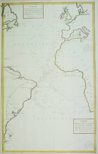
1788M6850Paris 1788. Very Good; laid on acid-free paper for long-term preservation. Notes: This handsome sea chart that indicates magnetic needle readings along various routes through the Atlantic. Size : 850x532 mm 33.46x20.94 Inches Coloring: Hand Colored in Outline Category: Maps Sea Chart; Maps Ocean Atlantic; unknown
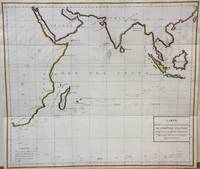
1788M7032Paris 1788. Very Good;. Notes: An 18th century mapping of the Indian Ocean. This handsome sea chart depicts magnetic needle readings along various routes in the ocean from the Cape of Good Hope le Cap des Aiguilles to the South East Asian archipelago. Size : 511x583 mm 20.12x22.95 Inches Coloring: Hand Colored in Outline Category: Maps Sea Chart; Maps Ocean Indian; unknown
179755870Paris: 1797. A large and imposing sea chart of the North Pacific ocean. From the Voyages of La Pérouse who set sail from France in 1785 to continue the discoveries of Captain Cook. He was shipwrecked in 1788 but his narrative maps and views survived and were published in 1797. Copper engraving. Very good condition. Watermarks. Good margins. Hand coloured. Size: 68.5 x 49.5 cm. unknown
179953594Leipsick No publisher 1799. Contemp. hcalf. Spine gilt and with gilt lettering. XXXVI562 pp. 5 engraved plates and 1 large folded engraved world map: "Mappemonde ou Carte réduite des Parties connues du Globe pour servir au Voyage de la Pérouse." 52 x 425 cm. A few margins of text at beginning and at end stained. The portrait lacks. <br/><br/><em>Sabin 38959. </em> unknown
179953594Leipsick, No publisher, 1799. Contemp. hcalf. Spine gilt and with gilt lettering. XXXVI,562 pp., 5 engraved plates and 1 large folded engraved world map: ""Mappemonde ou Carte réduite des Parties connues du Globe pour servir au Voyage de la Pérouse..."" (52 x 42,5 cm.). A few margins of text at beginning and at end stained. The portrait lacks.
29518Paris, Au Bureau de la Publication, s.d. (1845 ?]. 12 volumes, in-8. demi-chagrin rouge, dos à 4 nerfs, caissons richement ornés, auteur, titre et tomaison en lettres dorées. Tome 1 : LXXVI- introduction d'Aug. Duponchel. - 2 pages de Notice sur la vie de Georges Anson -363 pages. Voyage autour du monde EN 1740, 1741, 1742, 1743, et 1744, par G. Anson. Voyage autour du monde en 1764, 1765 et 1766,par le Commodore Byron, sur le vaisseau le Dauphin. Voyage autour du monde pendant les années 1766, 1767, 1768 et 1769, par Bougainville. 1 carte dépliante de L'Océanie et 8 planches.Tome II. 393 pages. Notice sur la vie du Capitaine Cook commandant le vaisseau du roi L'Endravour. Voyages autour du monde en 1768, 1769, 1770 et 1771 par J. Cook. 9 Planches.Tome III. 403 pages. Suite du premier voyage du Capitaine Cook. 8 planches.Tome IV. 396 pages. Suite du deuxième voyage du Capitaine Cook. Troisième Voyage. 8 planches.+ 2 planches signalées dans le tome V par **.Tome V. 396 pages. Troisième voyage du Capitaine Cook. 11 planches (dont 2 devant être placées dans le tome IV.Tome VI. 388 pages. Notice sur la vie de La Pérouse. Voyage autour du monde 1785-1788 par La Pérouse. Voyage de découvertes aux Terres Australes exécuté par le Capitaine Baudin. Voyage autour du monde de la Corvette L'Uranie, commandé par M. Louis de Freycinet. Voyage autour du monde de la Corvette La Coquille commandé par M. Duperrey. Voyage de la Corvette L'Astrolabe commandée par M. Dumont dUrville. Expédition de L'Astrolabe et de La Zélée par M. Dumont d'Urville. 8 planches. Tome VII. 412 pages. Notice sur la vie de James Bruce. Voyage en Nubie et en Abyssinie pendant les années 1768 a 1772. 1 carte dépliante en couleurs de l'Afrique en fin de volume. 8 planches.Tome VIII. 441 pages. Précis historique. Voyages en Afrique de 1780 a 1785, par P. F. Le Vaillant. Second voyage de Le Vaillant en Afrique. 8 planches.Tome IX. 438 pages. Voyage dans l'intérieur de l'Afrique dans les années 1795-1797 par Mungo-Park. Second voyage de Mungo-Park dans l'intérieur de l'Afrique. Voyage à Temboctou et dans l'intérieur de l'Afrique de René Caillé. Voyage en Afrique effectué dans le but d'explorer le cours et l'embouchure du Niger par Richard et John Lander .8 planches.Tome X. 439 pages. Notice sur la vie de Chardin. Voyage en Perse par Chardin. Voyage aux Indes Orientales d'après Mistriss Graham, Heber Skinner, etc. 1 carte dépliante de l'Asie. 8 planches. Planches.Tome XI. 412 pages. Voyage en Chine et en Tartarie par Lord Macartney, Ambassadeur du Roi dAngleterre. Voyage au Mont Caucase par Klaproth. Voyage en Egypte et en Arabie par Niéburth suivi dune description de l'Arabie d'après les voyages modernes de Burckardt, Rupell et Léon de Laborde. Voyage de Saint Peters Bourg Tauris par Kotzbue. 8 planches.Tome XII. 400 pages. Notice sur la vie de Christophe Colomb. Voyages de Christophe Colomb. Conquête du Mexique par Fernand Cortez. Conquête du Pérou par Pizzare.Voyage aux Etats-Unis de l'Amérique Septentrionale d'après Basil-Hall, Levasseur et Georges De Beaumont. Voyage dans l'Amérique Septentrionale et particulièrement dans les territoires de la Floride, du Ouisconsin et au Canada par le Comte de Castelnau. Voyage au Pôle Nord et aux Régions Artiques par le Capitaine Ross.Voyage en Grèce et à Constantinople par F.C.H. Pouqueville.1 carte dépliante de l'Amérique Méridionale. 1 carte dépliante de l'Amérique Septentrionale. 7 planches.Tables de Matières dans chaque tome (non paginées).
1829PHO-1047Paris: Imprimerie Royale, 1829.1 vol. in-4 de 2ff-titre, table-124pp. , relié demi cuir , dos lisse avec pièce de titre ,1 grande carte trigonométrique des côtes occidentales de France, dépliante, dressée par Michel Daussy , mors frottés, intérieur à grande marge , très beau papier d’une grande fraîcheur
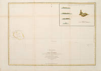
179755873Paris: 1797. From the Voyages of La Pérouse who set sail from France in 1785 to continue the discoveries of Captain Cook. He was shipwrecked in 1788 but his narrative maps and views survived and were published in 1797. Sea chart showing Necker Island a small island in the Pacific Ocean part of the Nortwestern Hawaiian Islands. La Perouse was the first European to visit the island in 1786. Map inset in the right top corner showing profiles of the island from different angles. Atlas Du Voyage De La Pérouse. Size: 680 x 485 mm. Copper engraving. Hand coloured. Very good condition. Faint waterstain to the left vertical fold. Good margins. Watermarks. Folds as issued. unknown
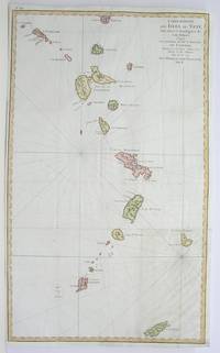
1796M3355Paris 1796. Very Good; lower margin extended. Size : 606x362 mm 23.875x14.25 Inches Coloring: Hand Colored Category: ; Maps West Indies Whole unknown
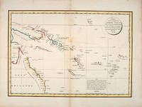
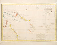
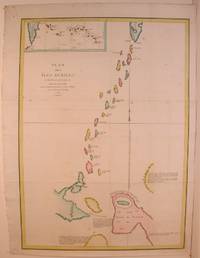
179755868Paris: 1797. Interesting chart of part of the south-western Pacific showing the routes taken by the Spanish explorer Don Francisco Antonio Maurelle in 1781 along the northern coast of New Guinea and across the Pacific to Fiji and Tonga. Maurelle was credited with the discovery of the Hermit Islands on this voyage. The map includes the north-eastern coast of Australia and parts of the coast of New Guinea. The map shows the 1781 route of his ship "The Princesa" through the Bismarck Archipelago north of New Guinea through the Archipel de Salomos i.e. Solomon Islands and then east across the Pacific to the Iles de Amis i.e. the Friendly Islands now Tonga where he discovered I. Vavao i.e. Vava'u with one of the best anchorages in the South Pacific. The map includes the Iles de Navigateurs i.e. Samoa I. Fidji i.e. Fiji Iles de Esprit i.e. Vanuatu or the New Hebrides Isles and Nouvelle Caledonie i.e. New Caledonia. Many small islands are depicted with notes regarding their sightings by Abel Tasman William Bligh and Maurelle. A note on the chart states that the publisher has placed the islands according to the longitude of other navigators rather than on Maurelle's figures which were considered estimates only and also that Maurelles chart was based on a French chart by Jacques Nicolas Bellin published in 1742. The French cartographers at the time did not consider the Spanish charts to be sufficiently accurate so they preferred to make their own corrections. Size: 490 x 340 mm. Copper engraving. Hand coloured. Good condition. Watermark slight browning and an old repair to the central fold. Good margins. unknown
178553439Atlas du Voyage de la Perouse. c.1785. Interesting chart of part of the south-western Pacific showing the routes taken by the Spanish explorer Don Francisco Antonio Maurelle in 1781 along the northern coast of New Guinea and across the Pacific to Fiji and Tonga. Maurelle was credited with the discovery of the Hermit Islands on this voyage. The map includes the north-eastern coast of Australia and parts of the coast of New Guinea. The map shows the 1781 route of his ship "The Princesa" through the Bismarck Archipelago north of New Guinea through the Archipel de Salomos i.e. Solomon Islands and then east across the Pacific to the Iles de Amis i.e. the Friendly Islands now Tonga where he discovered I. Vavao i.e. Vava'u with one of the best anchorages in the South Pacific. The map includes the Iles de Navigateurs i.e. Samoa I. Fidji i.e. Fiji Iles de Esprit i.e. Vanuatu or the New Hebrides Isles and Nouvelle Caledonie i.e. New Caledonia. Many small islands are depicted with notes regarding their sightings by Abel Tasman William Bligh and Maurelle. A note on the chart states that the publisher has placed the islands according to the longitude of other navigators rather than on Maurelle's figures which were considered estimates only and also that Maurelle's chart was based on a French chart by Jacques Nicolas Bellin published in 1742. The French cartographers at the time did not consider the Spanish charts to be sufficiently accurate so they preferred to make their own corrections. Copper engraving. Good condition. One light and one dark spot of foxing to the upper centre. A slight faint watermark. Later colour. Size: 49 x 34 cm. 19½ x 13½ inches unknown
179755878Paris: 1797. From the Voyages of La Pérouse who set sail from France in 1785 to continue the discoveries of Captain Cook. He was shipwrecked in 1788 but his narrative maps and views survived and were published in 1797. An attractive map of the regions North of Japan withs two inset maps: Extrait de la carte publiee par Scheuchzer -- Extrait de la carte de l'Histoire du Japon de Kampfer. Relief shown pictorially; depths by soundings. Oriented with north toward right. Atlas Du Voyage De La Pérouse. Size: 675 x 490 mm. Copper engraving. Hand coloured. Very good condition. A faint vertical waterstain. Good margins. unknown
179755652Paris. 1797. Scene showing inhabitants of Lituya Bay Alaska in native costume. From the Voyages of La Perouse who set sail from France in 1785 to continue the discoveries of Captain Cook. He was shipwrecked in 1788 but his narrative maps and views survived and were published in 1797. Atlas Du Voyage De La Pérouse. Copper engraving. Very good condition. slight browing around edges but not effecting image Uncoloured. Size: 40 x 25.5 cm. 15½ x 10 inches unknown
179755644Paris. 1797. A very beautiful print showing four elegant figures relaxing in a shady glade two women recline and two stand chatting. This print is from the Voyages of La Perouse who set sail from France in 1785 to continue the discoveries of Captain Cook. He was shipwrecked in 1788 but his narrative maps and views survived and were published in 1797. Atlas du Voyage de la Perouse Copper engraving. Good margins crisp clear impression very good condition. slight browning around edges but not effecting image Uncoloured. Size: 40 x 25.5 cm. unknown
179755671Paris. 1797. Scene showing local woman from Alaska. From the Voyages of La Pérouse who set sail from France in 1785 to continue the discoveries of Captain Cook. He was shipwrecked in 1788 but his narrative maps and views survived and were published in 1797. Atlas Du Voyage De La Pérouse. Size: 400 x 255 mm. Copper engraving. Uncoloured. Very good condition. Slight browing around edges but not effecting image. unknown
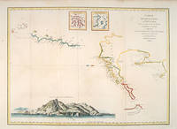
17973921Paris c. 1797. Copper engraving by Simonet after Duche de Vancy and J.M. Moreau le Jeune approx 29 x 42 cms trimmed to platemark left-hand margin extended hand-coloured blank verso. Map unknown
179755645Paris. 1797. This dramatic and attractive print is from the Voyages of La Perouse who set sail from France in 1785 to continue the discoveries of Captain Cook. He was shipwrecked in 1788 but his narrative maps and views survived and were published in 1797. Atlas du Voyage de la Perouse Copper engraving. Good margins crisp clear impression very good condition. slight browing around edges but not effecting image Uncoloured. Size: 40 x 25.5 cm. unknown
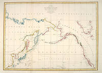
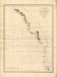
179724538Paris 1797. Other. In excellent condition. 690 by 490mm 27 by 19 inches. 690 by 490mm 27 by 19 inches. Copper Engraving uncolored by La Perouse Jean-Francois de Galup published 1797 by Paris. Image size: 690 by 490mm 27 by 19 inches. By Lapérouse — among the rarest and most historically important charts of the Northwest Coast ever produced. Jean-François de Galaup Comte de Lapérouse 1741–1788 was the foremost French navigator and explorer of the late 18th century. Commissioned by Louis XVI to lead a major scientific and commercial expedition to the Pacific he departed Brest in 1785 with two frigates — the Boussole and the Astrolabe — and spent three years charting the Pacific and North American coasts with extraordinary precision. His charts of the Northwest Coast of North America 1786 were the first scientific surveys of many sections of that coastline and were published posthumously in the celebrated four-volume Voyage de Lapérouse autour du monde 1797. The expedition disappeared without trace near Vanikoro in 1788. Lapérouse's charts are among the most historically important and rarest maps of the Pacific and Northwest Coast ever produced.This antique map of Carte Générale D `une Partie de la Cote du Nord-Quest. De L´ was published in 1797 by Paris 690 by 490mm 27 by 19 inches. It is printed as a copper engraving uncolored. The map documents the region with careful attention to rivers settlements roads and political boundaries reflecting the geographical knowledge available at the time of publication and offering an invaluable primary source for historians and collectors of North American antique cartography. In excellent condition. unknown
19713851A NICE. LES EDITIONS LE CHANT DES SPHERES. 1971-1972. 3 VOLUMES IN-4 (21,5 X 27 X 17 CENTIMETRES ENVIRON), RELIURE DE L’EDITEUR PLEIN VEAU HAVANE, PLATS ENTIEREMENT ORNES D'UN DECOR MARITIME ESTAMPE A FROID ET DORE, DOS A CINQ NERFS DECORE DE MEME, TITRE ET TETE DORES, SOUS ETUI BORDE. AVEC 50 ILLUSTRATIONS EN COULEURS DANS LE GOUT DE L'ENLUMINURE: 1 TITRE ILLUSTRE (REPRIS DANS CHAQUE VOLUME), 15 PLANCHES HORS TEXTE DONT 1 PLANCHE DOUBLE, 17 BANDEAUX ET 17 CULS-DE-LAMPE. AVEC UNE CARTE REPLIEE EN COULEURS HORS TEXTE PAR DA ROS ET LA REPRODUCTION DE DOCUMENTS ANCIENS. TEXTE ENCADRE DUNE GUIRLANDE A DECOR MARITIME EN BLEU. PREMIER TIRAGE LIMITE A 2030 EXEMPLAIRES NUMEROTES, DONT 30 HORS COMMERCE ET 20 RESERVES, TOUS SUR VELIN DE LANA. UN DES 250 NUMEROTES DE 1 A 250 ET COMPORTANT: UNE ILLUSTRATION ORIGINALE EN COULEURS SIGNEE, UN DESSIN ORIGINAL EN NOIR SIGNE ET UNE SUITE EN BISTRE DE LA DOUBLE PLANCHE ET DES ILLUSTRATIONS HORS TEXTE, CELUI-CI PORTANT LE NUMERO 144, ACCOMPAGNE DE SON CERTIFICAT D'AUTHENTICITE. BON EXEMPLAIRE.
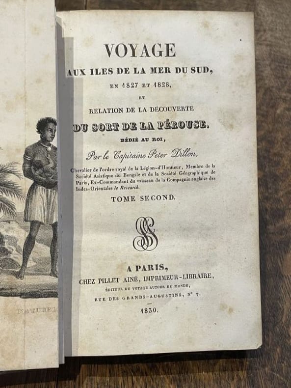
183098208Pillet 1830 2 vol. relié 2 vol. in-8, demi-veau glacé tabac, dos à nerfs rehaussés de frises dorées, caissons ornés de fleurons à froid et de filets et frises dorés, tranches marbrées, LX + 294 et 361, 1 frontispice dépliant (sur 2), 1 carte dépliante et 1 planche hors-texte (rousseurs éparses sinon fine reliure de l'époque agréablement patinée). Edition originale. Peter Dillon (1788-1847) est né en Martinique d'un père Irlandais de passage sur l'île. L'âme aventureuse, il se fait négociant en bois de santal et découvre le lieu d'échouage de l'expédition de La Pérouse sur l'île de Mannicolo dans l'archipel des Salomon. Manque le frontispice dépliant du tome I.
183098208Pillet 1830 2 vol. relié 2 vol. in-8, demi-veau glacé tabac, dos à nerfs rehaussés de frises dorées, caissons ornés de fleurons à froid et de filets et frises dorés, tranches marbrées, LX + 294 et 361, 1 frontispice dépliant (sur 2), 1 carte dépliante et 1 planche hors-texte (rousseurs éparses sinon fine reliure de l'époque agréablement patinée). Edition originale. Peter Dillon (1788-1847) est né en Martinique d'un père Irlandais de passage sur l'île. L'âme aventureuse, il se fait négociant en bois de santal et découvre le lieu d'échouage de l'expédition de La Pérouse sur l'île de Mannicolo dans l'archipel des Salomon. Manque le frontispice dépliant du tome I.
1788M4779Paris 1788. Very Good. Size : 685x495 mm 27x19.5 Inches Coloring: Hand Colored Category: Maps Russia; Maps Asia Far East Japan & Korea; unknown
179755871Paris: 1797. From the Voyages of La Pérouse who set sail from France in 1785 to continue the discoveries of Captain Cook. He was shipwrecked in 1788 but his narrative maps and views survived and were published in 1797. Two watermarks one on each side of the islands. Engraved by Bouclet. Atlas Du Voyage De La Pérouse. Size: 680 x 495 mm. Copper engraving. Hand coloured. Very good condition. Faint waterstain on the left vertical fold and slight foxing to the upper horizontal fold not affecting the image. Good margins. unknown
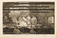
179755669Paris. 1797. Scene showing people warming themselves by a fire in a log cabin. From the Voyages of La Pérouse who set sail from France in 1785 to continue the discoveries of Captain Cook. He was shipwrecked in 1788 but his narrative maps and views survived and were published in 1797. Atlas Du Voyage De La Pérouse. Size: 40 x 25.5 mm. Copper engraving. Uncoloured. Very good condition. slight browing around edges but not effecting image. unknown
17956309Paris, Everat, sans date [1795]. In-8 de [4]-397-II-[1] pages [signatures: 2; A-Z8; Aa-Bb8], demi-basane rouge, dos orné de fleurons et filets dorés, pièces de titre en percaline brique, tête rouge, second plat de couverture conservé (reliure moderne).