LA PEROUSE, Jean Francois de GalaupBiblio.com
162 résultats
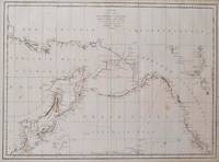
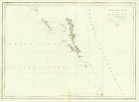
179756360Paris. 1797. From the Voyages of La Pérouse who set sail from France in 1785 to continue the discoveries of Captain Cook. He was shipwrecked in 1788 but his narrative maps and views survived and were published in 1797. Thirty-eight years later the scattered remains of La Boussole and L'Astrolabe was discovered wrecked on a vicious reef on an atoll in the New Hebrides. Attractive sea chart covering coast from Mt. St. Elias to Monterey Bay. Relief shown by hachures. Shows route of La Perouse. Published in 'Atlas Du Voyage De La Pérouse'. Size: 575 x 845 mm. Copper engraving. Hand coloured. Very good condition; some light stains along the lower horizontal fold; a tear and some foxing to the upper margin; wide margins. unknown
179755667Paris. 1797. From the Voyages of La Perouse who set sail from France in 1785 to continue the discoveries of Captain Cook. He was shipwrecked in 1788 but his narrative maps and views survived and were published in 1797. Atlas Du Voyage De La Pérouse. Size: 400 x 255 mm. Copper engraving. Uncoloured. Very good condition. slight browing around edges but not effecting image. unknown
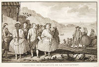
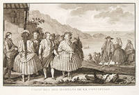
179755650Paris. 1797. View of Chile showing the costumes of its inhabitants from the Voyages of La Perouse who set sail from France in 1785 to continue the discoveries of Captain Cook. He was shipwrecked in 1788 but his narrative maps and views survived and were published in 1797. Atlas Du Voyage De La Pérouse. Copper engraving. Very good condition. slight browing around edges but not effecting image Uncoloured. Size: 40 x 25.5 cm. unknown
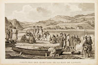
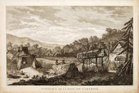
179755666Paris. 1797. Scene showing inhabitants of Lituya Bay Alaska in fishing season. From the Voyages of La Perouse who set sail from France in 1785 to continue the discoveries of Captain Cook. He was shipwrecked in 1788 but his narrative maps and views survived and were published in 1797. Atlas Du Voyage De La Pérouse. Size: 400 x 255 mm. Copper engraving. Uncoloured. Very good condition. slight browing around edges but not effecting image. unknown
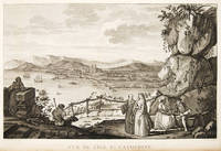
179755649Paris. 1797. View of Brazil from the Voyages of La Perouse who set sail from France in 1785 to continue the discoveries of Captain Cook. He was shipwrecked in 1788 but his narrative maps and views survived and were published in 1797. Atlas Du Voyage De La Pérouse. Copper engraving. Very good condition. slight browing around edges but not effecting image. Uncoloured. Size: 40 x 25.5 cm. unknown
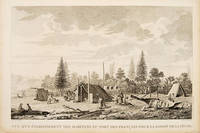
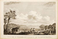
179755670Atlas Du Voyage De La Pérouse. 1797. View of St Pierre and St Paul in Kamtschatka. From the Voyages of La Pérouse who set sail from France in 1785 to continue the discoveries of Captain Cook. He was shipwrecked in 1788 but his narrative maps and views survived and were published in 1797. Size: 400 x 255 mm. Copper engraving. Uncoloured. Very good condition. slight browing around edges but not effecting image. unknown
19721770A NICE. LES EDITIONS LE CHANT DES SPHERES. 1971-1972. 3 VOLUMES IN-4 (21,5 X 27 X 17 CENTIMETRES ENVIRON), RELIURE DE L’EDITEUR PLEIN VEAU HAVANE, PLATS ENTIEREMENT ORNES D'UN DECOR MARITIME ESTAMPE A FROID ET DORE, DOS A CINQ NERFS DECORE DE MEME, TITRE ET TETE DORES, SOUS ETUI BORDE. AVEC 50 ILLUSTRATIONS EN COULEURS DANS LE GOUT DE L'ENLUMINURE: 1 TITRE ILLUSTRE (REPRIS DANS CHAQUE VOLUME), 15 PLANCHES HORS TEXTE DONT 1 PLANCHE DOUBLE, 17 BANDEAUX ET 17 CULS-DE-LAMPE. AVEC UNE CARTE REPLIEE EN COULEURS HORS TEXTE PAR DA ROS ET LA REPRODUCTION DE DOCUMENTS ANCIENS. TEXTE ENCADRE DUNE GUIRLANDE A DECOR MARITIME EN BLEU. PREMIER TIRAGE LIMITE A 2030 EXEMPLAIRES NUMEROTES, DONT 30 HORS COMMERCE ET 20 RESERVES, TOUS SUR VELIN DE LANA. UN DES 250 NUMEROTES DE 1 A 250 ET COMPORTANT: UNE ILLUSTRATION ORIGINALE EN COULEURS SIGNEE, UN DESSIN ORIGINAL EN NOIR SIGNE ET UNE SUITE EN BISTRE DE LA DOUBLE PLANCHE ET DES ILLUSTRATIONS HORS TEXTE, CELUI-CI PORTANT LE NUMERO 25, ACCOMPAGNE DE SON CERTIFICAT D'AUTHENTICITE ET ENRICHI D’UN ENVOI AUTOGRAPHE SIGNE DE L’ILLUSTRATEUR. UN DOS INSOLE PETITS DEFAUTS EXTERIEURS, SINON BON EXEMPLAIRE.
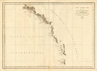
1797016791Paris: La Perouse 1797. Map. Very good condition. Unbound. First Edition. Folio. A large map in black and white. The map is included in the Atlas volume of La Perouse's Voyages. The west coast of North America is shown as south as Baja California and north to above 70 degrees latitude. Shows part of China and all of Japan and Kamtschatka and an attractive depiction of the Behring Straits and the Alaskan Archipelago. There are about a dozen small dark spots and dozens of others that are tiny but the map remains quite clean retaining large margins. La Perouse Paperback
179938451London: G.G. & J. Robinson 1799. Original copper engraving. This detailed map shows the south eastern part of Alaska.<br/> <br/> A fine copy of this engraving from Robinson's edition "usually considered to be the best one in English . and is extremely rare" Hill picturing and charting La Perouse's ill-fated voyage round the world. "La Pérouse's expedition was one of the most important scientific explorations ever undertaken to the Pacific and the west coast of North America . The charge to the expedition which took place between 1785 and 1788 was to examine such parts of the region as had not been explored by Captain Cook; to seek for an interoceanic passage; to make scientific observations on the various countries peoples and products; to obtain reliable information about the fur trade and the extent of Spanish settlements in California; and to promote the inducements for French enterprise in that quarter . La Pérouse and his men did important geographical research . The voyage also included the first foreign scientific group ever to visit California. La Pérouse sent dispatches back to France from Kamchatka and Botany Bay. The two ships then set sail from Botany Bay in 1788 and were never heard from again" Hill. It was not until the 1820s that the wrecks of his ships were discovered on a reef in the Santa Cruz group. When it became clear that something had happened to the expedition a decision was made to publish the journals he had transmitted home.<br/> <br/> Cowan p.383; Ferguson 288; Hill 2004 975; Howes L93 'b'; Lada-Mocarski 52; Sabin 38962; TPL 596; Wagner Cartography of the Northwest Coast 837-848 pp.199-201; Zamorano 49. G.G. & J. Robinson unknown
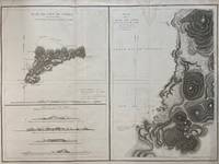
1797299774Paris: L'Imprimerie de la Republique 1797. Map. Engraving with hand coloring. Sheet measures 21 1/4" x 28"<br/> <br/> This chart depicts Easter Island with a close-up of Cook's Bay. Relief is depicted by hachure and elevation is shown from several vantage points. Points and peaks of the elevation views correspond to labels on the map. The Bay shows depths and various structures are labeled. The map appeared as Plate 10 in "Atlas du Voyage de La Perouse." It is in very good condition. Stain to upper margin minor foxing marks.<br> <br> Jean Francois de Galaup 1741-c.1788 was a French Navy officer and explorer known for his travels in Oceania. In 1787 he explored the northeast and mainland Asian coasts in the area of Korea. Other voyages included Alaska Japan Australia and the South Pacific. This map demonstrates some of the many observations and findings made on his journeys.<br/> <br/> L'Imprimerie de la Republique unknown
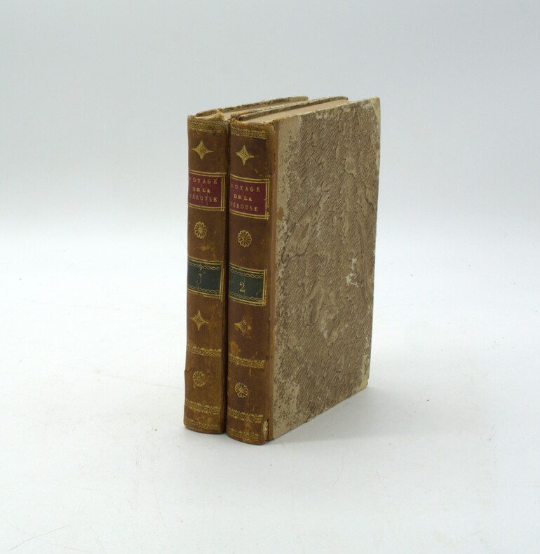
1799PHO-2288Paris, Jansen, an VIII (1799) 2 vol. in-8, demi-veau havane, dos lisse orné, avec pièces de titre rouge et tomaison verte. Tome I : xvi pp. (dont faux-titre et titre), 440 pp., Tome II : 332 pp. (dont le faux-titre et le titre), 109 pp., (1) f., quelques brunissures, frottements, coiffes absentes ou usées, début de fente (tome 1), accrocs aux dos, petit manque de matière (tome 2).
1797LBW-3733[Paris, 1797]. 684 x 492 mm.
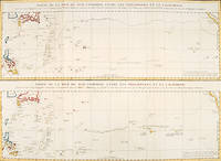
179756361Paris: 1797. An interesting large sheet with two maps covering the same area. The top chart shows the routes of the Spanish galleons from Acapulco to the Philippines. The bottom chart shows La Perouse's route from Monterey through Hawaii and the Marianas to Macao. From the Voyages of La Pérouse who set sail from France in 1785 to continue the discoveries of Captain Cook. He was shipwrecked in 1788 but his narrative maps and views survived and were published in 1797. Thirty-eight years later the scattered remains of La Boussole and L'Astrolabe was discovered wrecked on a vicious reef on an atoll in the New Hebrides. Full title: "Partie de la Mer du Sud comprise entre les Philippines et la Californie d'apres de Carte Espagnole trouvee sur le Galion pris par l'Amiral Anson en 1743 qui represente l'etat des connaissances a cette epoque et les routes que suivaient ordinairement les Galions dans leur traversee de Manille a Acapulco. Partie de la Mer du Sud comprise entre les Philippines et la California d'apres une autre Carte Espagnole communiquee a La Perouse dans sa relache a Monterey sur laquelle il avait trace sa route ainsi que les Iles qu'il avait reconnues avec des notes sur celles qu'il n'avait pas retrouvee." Copper engraving. Very good condition; some light stains along the lower horizontal fold; a tear and some foxing to the upper margin; wide margins. Hand coloured. Size: 79 x 55.5 cm. unknown
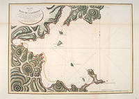
179755877Atlas Du Voyage De La Pérouse. Paris: L'Imprimerie de la Republique. 1797. From the Voyages of La Pérouse who set sail from France in 1785 to continue the discoveries of Captain Cook. He was shipwrecked in 1788 but his narrative maps and views survived and were published in 1797. An attractive sea chart showing a bay at the coast of Eastern Tartary. Relief shown by hachures; depths by soundings. This is how this part of La Pérouse's journey was described in a diary: 'On 11 August they reached the southwestern point of Sakhalin Island which La Pérouse named Cap Crillon Mys Kril'on. The ships anchored near Mys Kril'on and Vaujuas went ashore where he met more Ainu people some of whom also visited the ship. The ships began to sail through the strait the next day. La Pérouse called it Canal de Castries but it would later be called La Perouse Strait.' Copper engraving. Very good condition. Faint vertical waterstains. Some very slight browning to lower margin. Good margins. Hand coloured. Size: 68 x 49 cm. 27 x 19½ inches unknown
19713242A NICE. LES EDITIONS LE CHANT DES SPHERES. 1971-1972. 3 VOLUMES IN-4 (21,5 X 27 X 17 CENTIMETRES ENVIRON), RELIURE DE L’EDITEUR PLEIN VEAU BLEU, PLATS ENTIEREMENT ORNES D'UN DECOR MARITIME ESTAMPE A FROID ET DORE, DOS A CINQ NERFS DECORE DE MEME, TITRE ET TETE DORES, SOUS ETUI BORDE. AVEC 50 ILLUSTRATIONS EN COULEURS DANS LE GOUT DE L'ENLUMINURE: 1 TITRE ILLUSTRE (REPRIS DANS CHAQUE VOLUME), 15 PLANCHES HORS TEXTE DONT 1 PLANCHE DOUBLE, 17 BANDEAUX ET 17 CULS-DE-LAMPE. AVEC UNE CARTE REPLIEE EN COULEURS HORS TEXTE PAR DA ROS ET LA REPRODUCTION DE DOCUMENTS ANCIENS. TEXTE ENCADRE DUNE GUIRLANDE A DECOR MARITIME EN BLEU. PREMIER TIRAGE LIMITE A 2030 EXEMPLAIRES NUMEROTES, DONT 30 HORS COMMERCE ET 20 RESERVES, TOUS SUR VELIN DE LANA, CELUI-CI PORTANT LE NUMERO 1936, ACCOMPAGNE DE SON CERTIFICAT D'AUTHENTICITE. DOS ECLAIRCIS, PETITS DEFAUTS SANS AUCUNE GRAVIRE AU NIVEAU DES ETUIS, SINON BON EXEMPLAIRE.
179755668Atlas Du Voyage De La Pérouse. 1797. From the Voyages of La Pérouse who set sail from France in 1785 to continue the discoveries of Captain Cook. He was shipwrecked in 1788 but his narrative maps and views survived and were published in 1797. Size: 400 x 255 mm. Copper engraving. Uncoloured. Very good condition. slight browing around edges not affecting image. unknown
178624580Paris 1786. Other. In excellent condition. 490 by 860mm 19¼ by 33¾ inches. Copper engraving uncolored as published. unknown
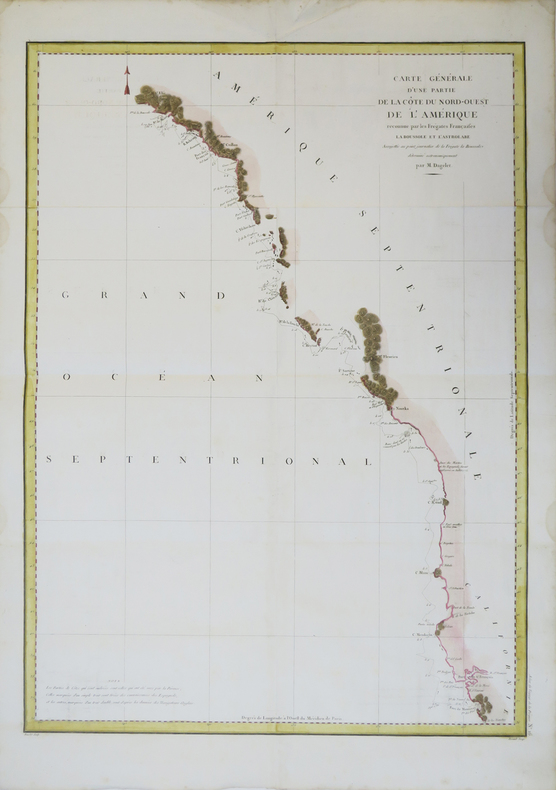
178624536Paris 1786. Other. In excellent condition. 495 by 685mm 19 by 27 inches. 495 by 685mm 19 by 27 inches. Copper Engraving uncolored by La Perouse Jean-Francois de Galup published 1786 by Paris. Image size: 495 by 685mm 19 by 27 inches. By Lapérouse among the rarest and most historically important charts of the Northwest Coast ever produced. Jean-François de Galaup Comte de Lapérouse 17411788 was the foremost French navigator and explorer of the late 18th century. Commissioned by Louis XVI to lead a major scientific and commercial expedition to the Pacific he departed Brest in 1785 with two frigates the Boussole and the Astrolabe and spent three years charting the Pacific and North American coasts with extraordinary precision. His charts of the Northwest Coast of North America 1786 were the first scientific surveys of many sections of that coastline and were published posthumously in the celebrated four-volume Voyage de Lapérouse autour du monde 1797. The expedition disappeared without trace near Vanikoro in 1788. Lapérouse's charts are among the most historically important and rarest maps of the Pacific and Northwest Coast ever produced.This antique map of Carte Particuliere de la Còte du Nord-Quest de L Amerique r was published in 1786 by Paris 495 by 685mm 19 by 27 inches. It is printed as a copper engraving uncolored. The map documents the region with careful attention to rivers settlements roads and political boundaries reflecting the geographical knowledge available at the time of publication and offering an invaluable primary source for historians and collectors of North American antique cartography. In excellent condition. 495 by 685mm 19 by 27 inches. unknown
1797M2909Paris 1797. Very Good; light dampstain on lower margin. Size : 494x677 mm 19.375x26.625 Inches Coloring: Black & White Category: Maps Polar Arctic Regions Alaska Greenland Iceland; unknown
174052760Atlas du Voyage de la Pérouse. c.1740. A beautiful picture with four people in the foreground and others in the background against a backdrop of the sea. Engraved by Thomas. Atlas du Voyage de la Pérouse. Original copper engraving. Fine condition. Black & white. Size: 39.6 x 26.5 cm. unknown
1798496London: G & T Robinson 1798. The English edition of a map published to accompany La Perouse' Voyage. G&T Robinson Nov. 1st 1798. Covers from the Gulf of Carpentaria to the Solitaire Islands to the Navigator Islands in the east and to above New Guinea. Charts Maurelle's tracks. G & T Robinson unknown
1797016788Paris: La Perouse 1797. Map. Very good condition. Unbound. First Edition. Folio. A large map beautifully decorated with original outline color. The map is included in the Atlas volume of La Perouse's Voyages but was drawn from Spanish manuscripts as it was thought that it might be a part of the Northwest Passage. The map has an extra vertical crease from mis-folding but is quite clean and has large margins which are lightly soiled here and there. La Perouse Paperback
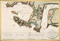
179756362Paris: 1797. Fine sea chart of the bay and Bio Bio River region with great topographical and hydrological detail. Villages and Fort St. Pierre are depicted. From the Voyages of La Pérouse who set sail from France in 1785 to continue the discoveries of Captain Cook. He was shipwrecked in 1788 but his narrative maps and views survived and were published in 1797. Thirty-eight years later the scattered remains of La Boussole and L'Astrolabe was discovered wrecked on a vicious reef on an atoll in the New Hebrides. Copper engraving. Very good condition; slight browning to the centrefold. Hand coloured. Size: 57 x 42 cm. unknown
1968208132Amsterdam. Nico Israel. 1968. 4to. 539547pp. Publisher's mylar djs on text volumes. Sl.discolouration to the spine of the atlas volume. Scarce. Bibliotheca Australiana nos. 27 28 & 29 Facsimile re-issue of the London edition of 1799. An interesting French perspective on the arrival of the First Fleet in 1788. Amsterdam. Nico Israel. unknown
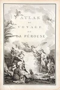
179066877Paris. c.1790. An extremely decorative title page featuring a huge scrolled map assorted angels and winged cherubs together with various seated and standing peoples of the world undoubtedly encountered during the La Perouse voyages. Size: 445 x 295 mm. Copperplate engraving. Good condition. unknown