La PerouseBiblio.com
75 résultats
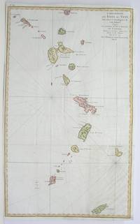
1796M3355Paris 1796. Very Good; lower margin extended. Size : 606x362 mm 23.875x14.25 Inches Coloring: Hand Colored Category: ; Maps West Indies Whole unknown
1797558961797. From the Voyages of La Pérouse who set sail from France in 1785 to continue the discoveries of Captain Cook. He was shipwrecked in 1788 but his narrative maps and views survived and were published in 1797. Thirty-eight years later the scattered remains of La Boussole and L'Astrolabe was discovered wrecked on a vicious reef on an atoll in the New Hebrides. Engraved by Le Pagelet. Size: 250 x 180 mm. Fine condition. Some foxing to the lower margin not affecting the image. unknown
179938451London: G.G. & J. Robinson 1799. Original copper engraving. This detailed map shows the south eastern part of Alaska.<br/> <br/> A fine copy of this engraving from Robinson's edition "usually considered to be the best one in English . and is extremely rare" Hill picturing and charting La Perouse's ill-fated voyage round the world. "La Pérouse's expedition was one of the most important scientific explorations ever undertaken to the Pacific and the west coast of North America . The charge to the expedition which took place between 1785 and 1788 was to examine such parts of the region as had not been explored by Captain Cook; to seek for an interoceanic passage; to make scientific observations on the various countries peoples and products; to obtain reliable information about the fur trade and the extent of Spanish settlements in California; and to promote the inducements for French enterprise in that quarter . La Pérouse and his men did important geographical research . The voyage also included the first foreign scientific group ever to visit California. La Pérouse sent dispatches back to France from Kamchatka and Botany Bay. The two ships then set sail from Botany Bay in 1788 and were never heard from again" Hill. It was not until the 1820s that the wrecks of his ships were discovered on a reef in the Santa Cruz group. When it became clear that something had happened to the expedition a decision was made to publish the journals he had transmitted home.<br/> <br/> Cowan p.383; Ferguson 288; Hill 2004 975; Howes L93 'b'; Lada-Mocarski 52; Sabin 38962; TPL 596; Wagner Cartography of the Northwest Coast 837-848 pp.199-201; Zamorano 49. G.G. & J. Robinson unknown
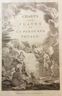
179843609London: Published as the Act directs Nov 1st 1798. by G.G.& J. Robinson 1798. Folio. 43x 27cm. 17" x 14.5". Atlas Volume First English Edition foliated engraved frontis portrait and engraved title-page 68 fine engraved plates maps charts and views many double page and include several plate illustrations on botanical and ornithological subjects. The plates are numbered 2 - 69 without the world map as usual plates are all very good to fine in contemporary half crimson morocco and marbled boards binding heavily dust worn similar wear on the edges upper hinge loose internally very good to fine condition. The map of the world is sometimes described as wanting however it would usually be in the two volume and is not call for in the list of plates <br /> <br /> ~ ~ ~ Hill #'s 972-979. "La Perouse expedition was one of the most important scientific explorations ever undertaken to the Pacific and North West Coast of North America. Hill. "Sabin 38960; Cox I-67. Fine copy of this Important 'Surveying Atlas' to the Pacific and west coast of North America. 1798. The plates are spectacular. - Atlas to the English edition of the report of the famous voyage around the world. Cook Bougainville and La Pérouse contributed decisively to the exploration of the Pacific. <br /> On the unexpected publication of this famous voyage at Paris in the previous year 1797 there was considerable competition among English publishers to bring out the English translation. Three different translations were made and published during 1798-99 and different engravers were employed for making the plates. Stockdale's appeared first in June 1798. Robinson's edition of 1799 is the most esteemed edition in English later editions being usually based on it." The atlas bears the date 1798 in the imprint but was published together with two text volumes in 1799. Published, as the Act directs, Nov, 1st, 1798. by G.G.& J. Robinson unknown
1798000252<p><strong>Atlas to the English edition of the report of the famous voyage around the world by La Pérouse who - in addition to Bougainville and Cook - contributed decisively to the exploration of the Pacific region. Without the two text volumes.</strong></p><p><strong>Description:</strong> Contemporary quarter calf with marbled paper boards. Flat spine lettered and decorated in gilt. Quarto: 44 × 28.5 cm; unpag. 1 engr. frontispiece 1 engr. title page and 67 full-page copper-engraved plates thereof are: 37 plates and 30 maps 20 fold-outs.</p><p><strong>Ref.:</strong> Boucher i p. 149-54; Cox i 67; Sabin 3896</p><p><strong>Condition:</strong> Binding a bit scuffed and with a few surface abrasions at edges. Light waterstains to the gutter of first few leaves. Contents occasionally somewhat soiled more noticeable in the first few leaves slight tanning at edges. Three small brown spots on plate 29 visible between plates 27-37. Lacking plates 1 map of the world and 36 male and female Partridge of California. Some offsetting from plates. Despite the occasional minor blemish a good copy.</p><p><strong>Notes:</strong> La Pérouse 1741-1788 a French naval officer and explorer was appointed in 1785 to lead a scientific expedition to explore the Pacific. The expedition stopped in Chile Hawaii Alaska California Mauritius Réunion Macau Japan Russia and Australia. However his journey ended tragically. In January 1788 he reached Botany Bay. He sent his final notes to France from there before sailing on towards Tonga in March. When no further reports arrived in France for a long period of time the first search expedition was launched in 1791. However it remained unsuccessful. It was not until 1826 that Peter Dillon an Irish sea captain proved that the island of Vanikoro was the site of the accident where the expedition's ships met a tragic end on the reef.</p><p>The first English edition was published in two volumes in octavo format by John Stockdale in London in 1798. Two other translations were published by two different publishers in 1798 and 1799: J. Johnson's first edition appeared in 1798 and J. Robinson's in 1799. Regarding these editions Edward Cox writes in his Reference Guide to the Literature of Travel: "On the unexpected publication of this famous voyage at Paris in the previous year 1797 there was considerable competition among English publishers to bring out the English translation. Three different translations were made and published during 1798-99 and different engravers were employed for making the plates. Stockdale's appeared first in June 1798. Robinson's edition of 1799 is the most esteemed edition in English later editions being usually based on it."</p> G. G. & J. Robinson hardcover
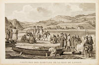
179755652Paris. 1797. Scene showing inhabitants of Lituya Bay Alaska in native costume. From the Voyages of La Perouse who set sail from France in 1785 to continue the discoveries of Captain Cook. He was shipwrecked in 1788 but his narrative maps and views survived and were published in 1797. Atlas Du Voyage De La Pérouse. Copper engraving. Very good condition. slight browing around edges but not effecting image Uncoloured. Size: 40 x 25.5 cm. 15½ x 10 inches unknown
179755667Paris. 1797. From the Voyages of La Perouse who set sail from France in 1785 to continue the discoveries of Captain Cook. He was shipwrecked in 1788 but his narrative maps and views survived and were published in 1797. Atlas Du Voyage De La Pérouse. Size: 400 x 255 mm. Copper engraving. Uncoloured. Very good condition. slight browing around edges but not effecting image. unknown
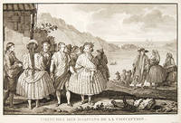
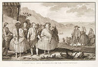
179755650Paris. 1797. View of Chile showing the costumes of its inhabitants from the Voyages of La Perouse who set sail from France in 1785 to continue the discoveries of Captain Cook. He was shipwrecked in 1788 but his narrative maps and views survived and were published in 1797. Atlas Du Voyage De La Pérouse. Copper engraving. Very good condition. slight browing around edges but not effecting image Uncoloured. Size: 40 x 25.5 cm. unknown
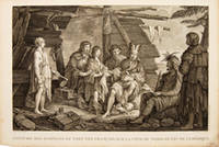
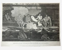
179755669Paris. 1797. Scene showing people warming themselves by a fire in a log cabin. From the Voyages of La Pérouse who set sail from France in 1785 to continue the discoveries of Captain Cook. He was shipwrecked in 1788 but his narrative maps and views survived and were published in 1797. Atlas Du Voyage De La Pérouse. Size: 40 x 25.5 mm. Copper engraving. Uncoloured. Very good condition. slight browing around edges but not effecting image. unknown
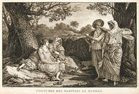
179755644Paris. 1797. A very beautiful print showing four elegant figures relaxing in a shady glade two women recline and two stand chatting. This print is from the Voyages of La Perouse who set sail from France in 1785 to continue the discoveries of Captain Cook. He was shipwrecked in 1788 but his narrative maps and views survived and were published in 1797. Atlas du Voyage de la Perouse Copper engraving. Good margins crisp clear impression very good condition. slight browning around edges but not effecting image Uncoloured. Size: 40 x 25.5 cm. unknown
174052760Atlas du Voyage de la Pérouse. c.1740. A beautiful picture with four people in the foreground and others in the background against a backdrop of the sea. Engraved by Thomas. Atlas du Voyage de la Pérouse. Original copper engraving. Fine condition. Black & white. Size: 39.6 x 26.5 cm. unknown
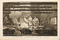
1798003682G. G & J. Robinson. LA PEROUSE Jean Francois; DUCHÉ DE VANCY Jean Baptiste; HEATH James. Dress of the Inhabitants of Baie de Castries. An engraving from the atlas volume of plates of the voyage of Jean-François de Galaup comte de La Pérouse published in London by G. G. & J. Robinson Paternoster Row 1798. Copper-engraving plate no. 54 after a drawing by the Duché de Vancy engraved by Heath with the imprint "Published as the Act directs Nov. 1st 1798". 330x220mm light uniform toning mild marginal soiling a little show-through from the verso but a clean well-defined impression with good margins. Overall very good. Image depicting domestic life costume and material culture of the Indigenous inhabitants of Baie de Castries on the north-west coast of America then described as the eastern coast of "Tartary" in contemporary French and British geographical usage. This plate forms part of the celebrated series of engravings prepared for the posthumous publication of La Pérouse's voyage 1785-1788 documenting the French expedition's survey of the North Pacific including Alaska the Sea of Japan Kamchatka and the northwest coast of America. The draughtsman Jean-Baptiste Claude Duché de Vancy served as official artist to the expedition while Heath was one of the principal London engravers engaged for the English edition of the atlas. The scene records the built environment clothing and domestic practices observed at Baie de Castries during La Pérouse's brief but historically important visit in 1786 shortly before the expedition's disappearance in the South Pacific. . Very Good. Soft cover. 1st Edition. 1st Printing. 1798. G. G & J. Robinson paperback
179755671Paris. 1797. Scene showing local woman from Alaska. From the Voyages of La Pérouse who set sail from France in 1785 to continue the discoveries of Captain Cook. He was shipwrecked in 1788 but his narrative maps and views survived and were published in 1797. Atlas Du Voyage De La Pérouse. Size: 400 x 255 mm. Copper engraving. Uncoloured. Very good condition. Slight browing around edges but not effecting image. unknown
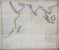
1788M7032Paris 1788. Very Good;. Notes: An 18th century mapping of the Indian Ocean. This handsome sea chart depicts magnetic needle readings along various routes in the ocean from the Cape of Good Hope le Cap des Aiguilles to the South East Asian archipelago. Size : 511x583 mm 20.12x22.95 Inches Coloring: Hand Colored in Outline Category: Maps Sea Chart; Maps Ocean Indian; unknown
1797014743Paris: L'Imprimerie de la Republique 1797. Print measures 40x25.cm. Some light surface wear stain mark on margin. Print in good clean condition. . Near Very Good. Illus. by Godefroy. L'Imprimerie de la Republique unknown
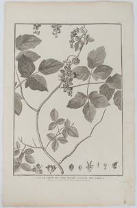
1798175968London. 1798. Engraving on watermarked wove paper 33.3 x 24.9 cm plate mark 42 x 26.6 cm sheet edges a little browned and dusty but a very good dark impression. Fine botanical illustration of the climbing chili prepared for the 'Account of the Voyage of Jean-François Galaup-La Pérouse' 1785-1788 the great but ill-fated French voyage of discovery and exploration. Guillaume Prevost was botanical artist on the ship L'Astrolabe and from a noted family of botanical artists. . unknown
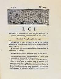
17913590A Dijon: De l'Imprimerie de Capel 1791. First edition. Woodcut headpiece. Contemporary manuscript certification at the end signed by two officials of the Département de la Côte-d'Or dated Dijon 23 avril 1791. Unbound as issued. In fine condition. First edition. Woodcut headpiece. Contemporary manuscript certification at the end signed by two officials of the Département de la Côte-d'Or dated Dijon 23 avril 1791. Unbound as issued. 3 1 blank p. <p><br /> The first formal document acknowledging fears of La Pérouse's disappearance in a rare provincial printing issued shortly after the royal decree.<br /> <p><p><br /> Very rare Dijon printing of the first formal decree acknowledging concern over the disappearance of La Pérouse's expedition. This decree issued by the Assemblée Nationale and promulgated in the name of Louis XVI on 25 February 1791 initiated the official search for La Boussole and L'Astrolabe last heard from in 1788 following their departure from Botany Bay. It instructed France's ambassadors consuls and agents abroad to solicit assistance from foreign powers and navigators-especially in the southern Pacific-"de faire toutes recherches des deux frégates Françoises La Boussole & L'Astrolabe. de même que toute perquisition qui pourroit constater leur existence ou naufrage."<br /> <p><p><br /> The decree also called for the arming of one or more vessels carrying scientists naturalists and artists tasked with both locating La Pérouse and conducting a broader exploratory mission "utile & avantageuse à la navigation à la géographie au commerce aux arts & aux sciences." This ultimately led to the voyage of Rear Admiral Bruni d'Entrecasteaux 1791-1794.<br /> <p><p><br /> La Pérouse's expedition 1785-88 commissioned by Louis XVI and modelled in part on the voyages of Cook was the most ambitious French maritime expedition of the Enlightenment. Departing from Brest in August 1785 the two frigates visited South America including Chile Easter Island Alaska California Macao the Philippines and Australia Botany Bay sending reports and scientific observations until their disappearance after March 1788. Their fate remained a mystery until the wreckage was found decades later on Vanikoro Island.<br /> <p><p><br /> The Dijon edition printed by Capel and officially certified by the departmental administration is part of a coordinated provincial dissemination of the decree alongside other issues printed in Pau Orléans Grenoble Valenciennes Auxerre and Évreux.<br /> <p><p><br /> References: cf. Ferguson 106a Auxerre ed.; Kroepelien 710; McLaren 132 Valenciennes ed.; Horner Looking for La Pérouse pp. 4-6.<br /> <p>. De l'Imprimerie de Capel unknown
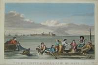
17973921Paris c. 1797. Copper engraving by Simonet after Duche de Vancy and J.M. Moreau le Jeune approx 29 x 42 cms trimmed to platemark left-hand margin extended hand-coloured blank verso. Map unknown
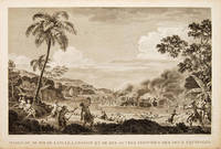
179755648Atlas Du Voyage De La Pérouse. 1797. Scene showing the locals attacking voyagers as they disembark from their boats. From the Voyages of La Pérouse who set sail from France in 1785 to continue the discoveries of Captain Cook. He was shipwrecked in 1788 but his narrative maps and views survived and were published in 1797. Copper engraving. Very good condition. slight browing around edges but not effecting image Uncoloured. Size: 40 x 25.5 cm. 15½ x 10 inches unknown
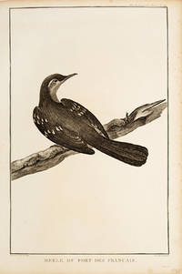
179755672Paris. 1797. Print of an Alaskan Merle Bird. From the Voyages of La Pérouse who set sail from France in 1785 to continue the discoveries of Captain Cook. He was shipwrecked in 1788 but his narrative maps and views survived and were published in 1797. Atlas Du Voyage De La Pérouse. Size: 255 x 400 mm. Copper engraving. Uncoloured. Very good condition. Slight browing around edges but not effecting image. unknown
1788M6851Paris 1788. Very Good; laid on acid-free canvas for long-term preservation. Notes: This handsome sea chart depicts magnetic needle readings along various routes in the North Pacific ocean.<br> Size : 590x1090 mm 23.23x42.91 Inches Coloring: Hand Colored in Outline Category: Maps Sea Chart; Maps Ocean Pacific; Maps United States West; unknown
1798496London: G & T Robinson 1798. The English edition of a map published to accompany La Perouse' Voyage. G&T Robinson Nov. 1st 1798. Covers from the Gulf of Carpentaria to the Solitaire Islands to the Navigator Islands in the east and to above New Guinea. Charts Maurelle's tracks. G & T Robinson unknown
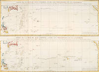
179756361Paris: 1797. An interesting large sheet with two maps covering the same area. The top chart shows the routes of the Spanish galleons from Acapulco to the Philippines. The bottom chart shows La Perouse's route from Monterey through Hawaii and the Marianas to Macao. From the Voyages of La Pérouse who set sail from France in 1785 to continue the discoveries of Captain Cook. He was shipwrecked in 1788 but his narrative maps and views survived and were published in 1797. Thirty-eight years later the scattered remains of La Boussole and L'Astrolabe was discovered wrecked on a vicious reef on an atoll in the New Hebrides. Full title: "Partie de la Mer du Sud comprise entre les Philippines et la Californie d'apres de Carte Espagnole trouvee sur le Galion pris par l'Amiral Anson en 1743 qui represente l'etat des connaissances a cette epoque et les routes que suivaient ordinairement les Galions dans leur traversee de Manille a Acapulco. Partie de la Mer du Sud comprise entre les Philippines et la California d'apres une autre Carte Espagnole communiquee a La Perouse dans sa relache a Monterey sur laquelle il avait trace sa route ainsi que les Iles qu'il avait reconnues avec des notes sur celles qu'il n'avait pas retrouvee." Copper engraving. Very good condition; some light stains along the lower horizontal fold; a tear and some foxing to the upper margin; wide margins. Hand coloured. Size: 79 x 55.5 cm. unknown
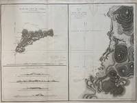
1797299774Paris: L'Imprimerie de la Republique 1797. Map. Engraving with hand coloring. Sheet measures 21 1/4" x 28"<br/> <br/> This chart depicts Easter Island with a close-up of Cook's Bay. Relief is depicted by hachure and elevation is shown from several vantage points. Points and peaks of the elevation views correspond to labels on the map. The Bay shows depths and various structures are labeled. The map appeared as Plate 10 in "Atlas du Voyage de La Perouse." It is in very good condition. Stain to upper margin minor foxing marks.<br> <br> Jean Francois de Galaup 1741-c.1788 was a French Navy officer and explorer known for his travels in Oceania. In 1787 he explored the northeast and mainland Asian coasts in the area of Korea. Other voyages included Alaska Japan Australia and the South Pacific. This map demonstrates some of the many observations and findings made on his journeys.<br/> <br/> L'Imprimerie de la Republique unknown
1797016788Paris: La Perouse 1797. Map. Very good condition. Unbound. First Edition. Folio. A large map beautifully decorated with original outline color. The map is included in the Atlas volume of La Perouse's Voyages but was drawn from Spanish manuscripts as it was thought that it might be a part of the Northwest Passage. The map has an extra vertical crease from mis-folding but is quite clean and has large margins which are lightly soiled here and there. La Perouse Paperback