La Perouse; BuffonBiblio.com
162 résultats
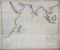
1788M7032Paris 1788. Very Good;. Notes: An 18th century mapping of the Indian Ocean. This handsome sea chart depicts magnetic needle readings along various routes in the ocean from the Cape of Good Hope le Cap des Aiguilles to the South East Asian archipelago. Size : 511x583 mm 20.12x22.95 Inches Coloring: Hand Colored in Outline Category: Maps Sea Chart; Maps Ocean Indian; unknown
QWA-15029F. Bechet, 1847, gr. in-8 rel. 1/2 peau marron (15,5 x 24), VIII-352 p., E.O., gravures h.-t., reliure d'époque modeste usagée en bordure, intérieur avec rousseurs éparses, assez bon état.
179755671Paris. 1797. Scene showing local woman from Alaska. From the Voyages of La Pérouse who set sail from France in 1785 to continue the discoveries of Captain Cook. He was shipwrecked in 1788 but his narrative maps and views survived and were published in 1797. Atlas Du Voyage De La Pérouse. Size: 400 x 255 mm. Copper engraving. Uncoloured. Very good condition. Slight browing around edges but not effecting image. unknown
1829PHO-1047Paris: Imprimerie Royale, 1829.1 vol. in-4 de 2ff-titre, table-124pp. , relié demi cuir , dos lisse avec pièce de titre ,1 grande carte trigonométrique des côtes occidentales de France, dépliante, dressée par Michel Daussy , mors frottés, intérieur à grande marge , très beau papier d’une grande fraîcheur
17956309Paris, Everat, sans date [1795]. In-8 de [4]-397-II-[1] pages [signatures: 2; A-Z8; Aa-Bb8], demi-basane rouge, dos orné de fleurons et filets dorés, pièces de titre en percaline brique, tête rouge, second plat de couverture conservé (reliure moderne).
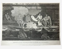
1798003682G. G & J. Robinson. LA PEROUSE Jean Francois; DUCHÉ DE VANCY Jean Baptiste; HEATH James. Dress of the Inhabitants of Baie de Castries. An engraving from the atlas volume of plates of the voyage of Jean-François de Galaup comte de La Pérouse published in London by G. G. & J. Robinson Paternoster Row 1798. Copper-engraving plate no. 54 after a drawing by the Duché de Vancy engraved by Heath with the imprint "Published as the Act directs Nov. 1st 1798". 330x220mm light uniform toning mild marginal soiling a little show-through from the verso but a clean well-defined impression with good margins. Overall very good. Image depicting domestic life costume and material culture of the Indigenous inhabitants of Baie de Castries on the north-west coast of America then described as the eastern coast of "Tartary" in contemporary French and British geographical usage. This plate forms part of the celebrated series of engravings prepared for the posthumous publication of La Pérouse's voyage 1785-1788 documenting the French expedition's survey of the North Pacific including Alaska the Sea of Japan Kamchatka and the northwest coast of America. The draughtsman Jean-Baptiste Claude Duché de Vancy served as official artist to the expedition while Heath was one of the principal London engravers engaged for the English edition of the atlas. The scene records the built environment clothing and domestic practices observed at Baie de Castries during La Pérouse's brief but historically important visit in 1786 shortly before the expedition's disappearance in the South Pacific. . Very Good. Soft cover. 1st Edition. 1st Printing. 1798. G. G & J. Robinson paperback
179755667Paris. 1797. From the Voyages of La Perouse who set sail from France in 1785 to continue the discoveries of Captain Cook. He was shipwrecked in 1788 but his narrative maps and views survived and were published in 1797. Atlas Du Voyage De La Pérouse. Size: 400 x 255 mm. Copper engraving. Uncoloured. Very good condition. slight browing around edges but not effecting image. unknown
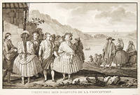
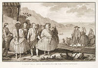
179755650Paris. 1797. View of Chile showing the costumes of its inhabitants from the Voyages of La Perouse who set sail from France in 1785 to continue the discoveries of Captain Cook. He was shipwrecked in 1788 but his narrative maps and views survived and were published in 1797. Atlas Du Voyage De La Pérouse. Copper engraving. Very good condition. slight browing around edges but not effecting image Uncoloured. Size: 40 x 25.5 cm. unknown
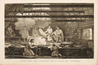
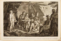
179755669Paris. 1797. Scene showing people warming themselves by a fire in a log cabin. From the Voyages of La Pérouse who set sail from France in 1785 to continue the discoveries of Captain Cook. He was shipwrecked in 1788 but his narrative maps and views survived and were published in 1797. Atlas Du Voyage De La Pérouse. Size: 40 x 25.5 mm. Copper engraving. Uncoloured. Very good condition. slight browing around edges but not effecting image. unknown
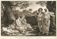
179755644Paris. 1797. A very beautiful print showing four elegant figures relaxing in a shady glade two women recline and two stand chatting. This print is from the Voyages of La Perouse who set sail from France in 1785 to continue the discoveries of Captain Cook. He was shipwrecked in 1788 but his narrative maps and views survived and were published in 1797. Atlas du Voyage de la Perouse Copper engraving. Good margins crisp clear impression very good condition. slight browning around edges but not effecting image Uncoloured. Size: 40 x 25.5 cm. unknown
174052760Atlas du Voyage de la Pérouse. c.1740. A beautiful picture with four people in the foreground and others in the background against a backdrop of the sea. Engraved by Thomas. Atlas du Voyage de la Pérouse. Original copper engraving. Fine condition. Black & white. Size: 39.6 x 26.5 cm. unknown
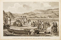
179755652Paris. 1797. Scene showing inhabitants of Lituya Bay Alaska in native costume. From the Voyages of La Perouse who set sail from France in 1785 to continue the discoveries of Captain Cook. He was shipwrecked in 1788 but his narrative maps and views survived and were published in 1797. Atlas Du Voyage De La Pérouse. Copper engraving. Very good condition. slight browing around edges but not effecting image Uncoloured. Size: 40 x 25.5 cm. 15½ x 10 inches unknown
29518Paris, Au Bureau de la Publication, s.d. (1845 ?]. 12 volumes, in-8. demi-chagrin rouge, dos à 4 nerfs, caissons richement ornés, auteur, titre et tomaison en lettres dorées. Tome 1 : LXXVI- introduction d'Aug. Duponchel. - 2 pages de Notice sur la vie de Georges Anson -363 pages. Voyage autour du monde EN 1740, 1741, 1742, 1743, et 1744, par G. Anson. Voyage autour du monde en 1764, 1765 et 1766,par le Commodore Byron, sur le vaisseau le Dauphin. Voyage autour du monde pendant les années 1766, 1767, 1768 et 1769, par Bougainville. 1 carte dépliante de L'Océanie et 8 planches.Tome II. 393 pages. Notice sur la vie du Capitaine Cook commandant le vaisseau du roi L'Endravour. Voyages autour du monde en 1768, 1769, 1770 et 1771 par J. Cook. 9 Planches.Tome III. 403 pages. Suite du premier voyage du Capitaine Cook. 8 planches.Tome IV. 396 pages. Suite du deuxième voyage du Capitaine Cook. Troisième Voyage. 8 planches.+ 2 planches signalées dans le tome V par **.Tome V. 396 pages. Troisième voyage du Capitaine Cook. 11 planches (dont 2 devant être placées dans le tome IV.Tome VI. 388 pages. Notice sur la vie de La Pérouse. Voyage autour du monde 1785-1788 par La Pérouse. Voyage de découvertes aux Terres Australes exécuté par le Capitaine Baudin. Voyage autour du monde de la Corvette L'Uranie, commandé par M. Louis de Freycinet. Voyage autour du monde de la Corvette La Coquille commandé par M. Duperrey. Voyage de la Corvette L'Astrolabe commandée par M. Dumont dUrville. Expédition de L'Astrolabe et de La Zélée par M. Dumont d'Urville. 8 planches. Tome VII. 412 pages. Notice sur la vie de James Bruce. Voyage en Nubie et en Abyssinie pendant les années 1768 a 1772. 1 carte dépliante en couleurs de l'Afrique en fin de volume. 8 planches.Tome VIII. 441 pages. Précis historique. Voyages en Afrique de 1780 a 1785, par P. F. Le Vaillant. Second voyage de Le Vaillant en Afrique. 8 planches.Tome IX. 438 pages. Voyage dans l'intérieur de l'Afrique dans les années 1795-1797 par Mungo-Park. Second voyage de Mungo-Park dans l'intérieur de l'Afrique. Voyage à Temboctou et dans l'intérieur de l'Afrique de René Caillé. Voyage en Afrique effectué dans le but d'explorer le cours et l'embouchure du Niger par Richard et John Lander .8 planches.Tome X. 439 pages. Notice sur la vie de Chardin. Voyage en Perse par Chardin. Voyage aux Indes Orientales d'après Mistriss Graham, Heber Skinner, etc. 1 carte dépliante de l'Asie. 8 planches. Planches.Tome XI. 412 pages. Voyage en Chine et en Tartarie par Lord Macartney, Ambassadeur du Roi dAngleterre. Voyage au Mont Caucase par Klaproth. Voyage en Egypte et en Arabie par Niéburth suivi dune description de l'Arabie d'après les voyages modernes de Burckardt, Rupell et Léon de Laborde. Voyage de Saint Peters Bourg Tauris par Kotzbue. 8 planches.Tome XII. 400 pages. Notice sur la vie de Christophe Colomb. Voyages de Christophe Colomb. Conquête du Mexique par Fernand Cortez. Conquête du Pérou par Pizzare.Voyage aux Etats-Unis de l'Amérique Septentrionale d'après Basil-Hall, Levasseur et Georges De Beaumont. Voyage dans l'Amérique Septentrionale et particulièrement dans les territoires de la Floride, du Ouisconsin et au Canada par le Comte de Castelnau. Voyage au Pôle Nord et aux Régions Artiques par le Capitaine Ross.Voyage en Grèce et à Constantinople par F.C.H. Pouqueville.1 carte dépliante de l'Amérique Méridionale. 1 carte dépliante de l'Amérique Septentrionale. 7 planches.Tables de Matières dans chaque tome (non paginées).
ABE-1347258033CHROMO DU MAGASIN HIGH LIFE TAILOR A PARIS-FORMAT 7 X 10 CM-(CLCHRO)
179843609London: Published as the Act directs Nov 1st 1798. by G.G.& J. Robinson 1798. Folio. 43x 27cm. 17" x 14.5". Atlas Volume First English Edition foliated engraved frontis portrait and engraved title-page 68 fine engraved plates maps charts and views many double page and include several plate illustrations on botanical and ornithological subjects. The plates are numbered 2 - 69 without the world map as usual plates are all very good to fine in contemporary half crimson morocco and marbled boards binding heavily dust worn similar wear on the edges upper hinge loose internally very good to fine condition. The map of the world is sometimes described as wanting however it would usually be in the two volume and is not call for in the list of plates <br /> <br /> ~ ~ ~ Hill #'s 972-979. "La Perouse expedition was one of the most important scientific explorations ever undertaken to the Pacific and North West Coast of North America. Hill. "Sabin 38960; Cox I-67. Fine copy of this Important 'Surveying Atlas' to the Pacific and west coast of North America. 1798. The plates are spectacular. - Atlas to the English edition of the report of the famous voyage around the world. Cook Bougainville and La Pérouse contributed decisively to the exploration of the Pacific. <br /> On the unexpected publication of this famous voyage at Paris in the previous year 1797 there was considerable competition among English publishers to bring out the English translation. Three different translations were made and published during 1798-99 and different engravers were employed for making the plates. Stockdale's appeared first in June 1798. Robinson's edition of 1799 is the most esteemed edition in English later editions being usually based on it." The atlas bears the date 1798 in the imprint but was published together with two text volumes in 1799. Published, as the Act directs, Nov, 1st, 1798. by G.G.& J. Robinson unknown
1798000252<p><strong>Atlas to the English edition of the report of the famous voyage around the world by La Pérouse who - in addition to Bougainville and Cook - contributed decisively to the exploration of the Pacific region. Without the two text volumes.</strong></p><p><strong>Description:</strong> Contemporary quarter calf with marbled paper boards. Flat spine lettered and decorated in gilt. Quarto: 44 × 28.5 cm; unpag. 1 engr. frontispiece 1 engr. title page and 67 full-page copper-engraved plates thereof are: 37 plates and 30 maps 20 fold-outs.</p><p><strong>Ref.:</strong> Boucher i p. 149-54; Cox i 67; Sabin 3896</p><p><strong>Condition:</strong> Binding a bit scuffed and with a few surface abrasions at edges. Light waterstains to the gutter of first few leaves. Contents occasionally somewhat soiled more noticeable in the first few leaves slight tanning at edges. Three small brown spots on plate 29 visible between plates 27-37. Lacking plates 1 map of the world and 36 male and female Partridge of California. Some offsetting from plates. Despite the occasional minor blemish a good copy.</p><p><strong>Notes:</strong> La Pérouse 1741-1788 a French naval officer and explorer was appointed in 1785 to lead a scientific expedition to explore the Pacific. The expedition stopped in Chile Hawaii Alaska California Mauritius Réunion Macau Japan Russia and Australia. However his journey ended tragically. In January 1788 he reached Botany Bay. He sent his final notes to France from there before sailing on towards Tonga in March. When no further reports arrived in France for a long period of time the first search expedition was launched in 1791. However it remained unsuccessful. It was not until 1826 that Peter Dillon an Irish sea captain proved that the island of Vanikoro was the site of the accident where the expedition's ships met a tragic end on the reef.</p><p>The first English edition was published in two volumes in octavo format by John Stockdale in London in 1798. Two other translations were published by two different publishers in 1798 and 1799: J. Johnson's first edition appeared in 1798 and J. Robinson's in 1799. Regarding these editions Edward Cox writes in his Reference Guide to the Literature of Travel: "On the unexpected publication of this famous voyage at Paris in the previous year 1797 there was considerable competition among English publishers to bring out the English translation. Three different translations were made and published during 1798-99 and different engravers were employed for making the plates. Stockdale's appeared first in June 1798. Robinson's edition of 1799 is the most esteemed edition in English later editions being usually based on it."</p> G. G. & J. Robinson hardcover
elala4672London: G.G. and J.Robinson 1798. cfWagner 841 & Falk Alaskan Maps 1797-9 French edition. 16 ºî x 21 ºî 41.3 x 54.3 cm. engraving paper weakness at centre fold London: G.G. and J.Robinson, 1798 unknown
elala4673London: G.G. and J.Robinson 1798. cfWagner 842 & Falk Alaskan Maps 1797-9 French edition. London. 16 ºî x 20 æî 41.3 x 52.1 cm. engraving paper weakness at centre fold London: G.G. and J.Robinson, 1798 unknown
179938451London: G.G. & J. Robinson 1799. Original copper engraving. This detailed map shows the south eastern part of Alaska.<br/> <br/> A fine copy of this engraving from Robinson's edition "usually considered to be the best one in English . and is extremely rare" Hill picturing and charting La Perouse's ill-fated voyage round the world. "La Pérouse's expedition was one of the most important scientific explorations ever undertaken to the Pacific and the west coast of North America . The charge to the expedition which took place between 1785 and 1788 was to examine such parts of the region as had not been explored by Captain Cook; to seek for an interoceanic passage; to make scientific observations on the various countries peoples and products; to obtain reliable information about the fur trade and the extent of Spanish settlements in California; and to promote the inducements for French enterprise in that quarter . La Pérouse and his men did important geographical research . The voyage also included the first foreign scientific group ever to visit California. La Pérouse sent dispatches back to France from Kamchatka and Botany Bay. The two ships then set sail from Botany Bay in 1788 and were never heard from again" Hill. It was not until the 1820s that the wrecks of his ships were discovered on a reef in the Santa Cruz group. When it became clear that something had happened to the expedition a decision was made to publish the journals he had transmitted home.<br/> <br/> Cowan p.383; Ferguson 288; Hill 2004 975; Howes L93 'b'; Lada-Mocarski 52; Sabin 38962; TPL 596; Wagner Cartography of the Northwest Coast 837-848 pp.199-201; Zamorano 49. G.G. & J. Robinson unknown
1797558961797. From the Voyages of La Pérouse who set sail from France in 1785 to continue the discoveries of Captain Cook. He was shipwrecked in 1788 but his narrative maps and views survived and were published in 1797. Thirty-eight years later the scattered remains of La Boussole and L'Astrolabe was discovered wrecked on a vicious reef on an atoll in the New Hebrides. Engraved by Le Pagelet. Size: 250 x 180 mm. Fine condition. Some foxing to the lower margin not affecting the image. unknown
1796M3355Paris 1796. Very Good; lower margin extended. Size : 606x362 mm 23.875x14.25 Inches Coloring: Hand Colored Category: ; Maps West Indies Whole unknown
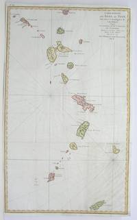
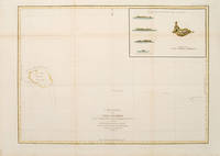
179755873Paris: 1797. From the Voyages of La Pérouse who set sail from France in 1785 to continue the discoveries of Captain Cook. He was shipwrecked in 1788 but his narrative maps and views survived and were published in 1797. Sea chart showing Necker Island a small island in the Pacific Ocean part of the Nortwestern Hawaiian Islands. La Perouse was the first European to visit the island in 1786. Map inset in the right top corner showing profiles of the island from different angles. Atlas Du Voyage De La Pérouse. Size: 680 x 485 mm. Copper engraving. Hand coloured. Very good condition. Faint waterstain to the left vertical fold. Good margins. Watermarks. Folds as issued. unknown
178624580Paris 1786. Other. In excellent condition. 490 by 860mm 19¼ by 33¾ inches. Copper engraving uncolored as published. unknown
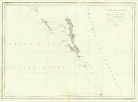
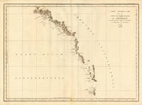
178624536Paris 1786. Other. In excellent condition. 495 by 685mm 19 by 27 inches. 495 by 685mm 19 by 27 inches. Copper Engraving uncolored by La Perouse Jean-Francois de Galup published 1786 by Paris. Image size: 495 by 685mm 19 by 27 inches. By Lapérouse among the rarest and most historically important charts of the Northwest Coast ever produced. Jean-François de Galaup Comte de Lapérouse 17411788 was the foremost French navigator and explorer of the late 18th century. Commissioned by Louis XVI to lead a major scientific and commercial expedition to the Pacific he departed Brest in 1785 with two frigates the Boussole and the Astrolabe and spent three years charting the Pacific and North American coasts with extraordinary precision. His charts of the Northwest Coast of North America 1786 were the first scientific surveys of many sections of that coastline and were published posthumously in the celebrated four-volume Voyage de Lapérouse autour du monde 1797. The expedition disappeared without trace near Vanikoro in 1788. Lapérouse's charts are among the most historically important and rarest maps of the Pacific and Northwest Coast ever produced.This antique map of Carte Particuliere de la Còte du Nord-Quest de L Amerique r was published in 1786 by Paris 495 by 685mm 19 by 27 inches. It is printed as a copper engraving uncolored. The map documents the region with careful attention to rivers settlements roads and political boundaries reflecting the geographical knowledge available at the time of publication and offering an invaluable primary source for historians and collectors of North American antique cartography. In excellent condition. 495 by 685mm 19 by 27 inches. unknown
1797M2909Paris 1797. Very Good; light dampstain on lower margin. Size : 494x677 mm 19.375x26.625 Inches Coloring: Black & White Category: Maps Polar Arctic Regions Alaska Greenland Iceland; unknown