LA BILLARDIÈRE, LABILLARDIÈRE (Jacques-Julien Houton de).Livre Rare Book
162 résultats
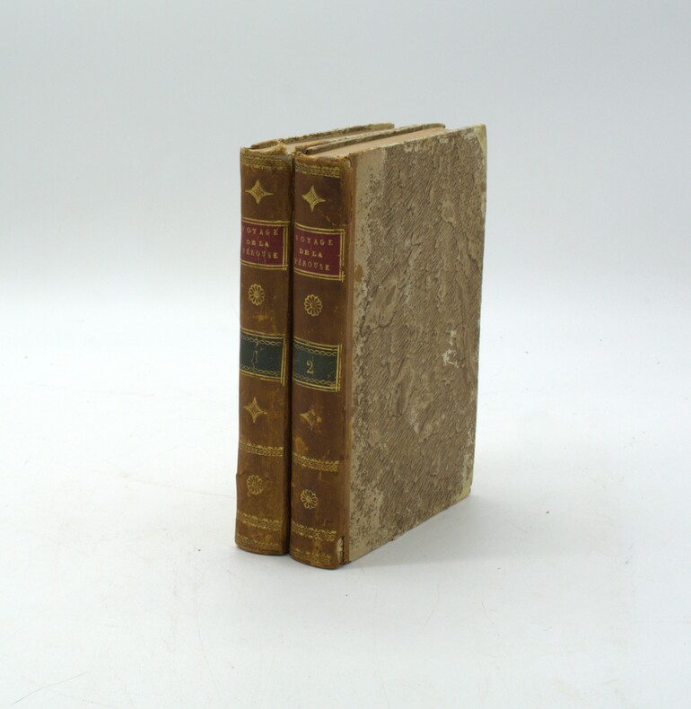
1799PHO-2288Paris, Jansen, an VIII (1799) 2 vol. in-8, demi-veau havane, dos lisse orné, avec pièces de titre rouge et tomaison verte. Tome I : xvi pp. (dont faux-titre et titre), 440 pp., Tome II : 332 pp. (dont le faux-titre et le titre), 109 pp., (1) f., quelques brunissures, frottements, coiffes absentes ou usées, début de fente (tome 1), accrocs aux dos, petit manque de matière (tome 2).
1800PHO-1086Texte In-8 (200 x 130 mm) Relié demi-basane, dos orné pièce de titre et de tomaison ,T1 manque coiffe sup.,T2 ,manque coiffes, papier bruni. 440 pp et 332 pp suivi de 109 pp de vocabulaire et table des planches contenues dans l’atlas, table des chapitres du volume et errata. ATLAS Atlas pour servir à la relation du voyage à la recherche de La Pérouse, fait par ordre de l’Assemblée constituante, Pendant les années 1791, 1792, et pendant la 1ere et 2eme année de la République Française. Paris : H. J. Jansen, An VIII de la République (1800). — In-folio, 510 x 335 : titre, 1 carte, 43 planches. Demi toile , dos lisse avec titre , planches 6 détachée et 35 détachée et émargée , dédicace «à Mr V. Rey, secrétaire général de la Nouvelle Calédonie,1903»
179953594Leipsick, No publisher, 1799. Contemp. hcalf. Spine gilt and with gilt lettering. XXXVI,562 pp., 5 engraved plates and 1 large folded engraved world map: ""Mappemonde ou Carte réduite des Parties connues du Globe pour servir au Voyage de la Pérouse..."" (52 x 42,5 cm.). A few margins of text at beginning and at end stained. The portrait lacks.
179953594Leipsick No publisher 1799. Contemp. hcalf. Spine gilt and with gilt lettering. XXXVI562 pp. 5 engraved plates and 1 large folded engraved world map: "Mappemonde ou Carte réduite des Parties connues du Globe pour servir au Voyage de la Pérouse." 52 x 425 cm. A few margins of text at beginning and at end stained. The portrait lacks. <br/><br/><em>Sabin 38959. </em> unknown
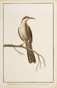
179755673Paris. 1797. Print of a Californian Cape bird. From the Voyages of La Pérouse who set sail from France in 1785 to continue the discoveries of Captain Cook. He was shipwrecked in 1788 but his narrative maps and views survived and were published in 1797. Atlas Du Voyage De La Pérouse Size: 255 x 400 mm. Copper engraving. Uncoloured. Very good condition. Slight browing around edges but not effecting image. unknown
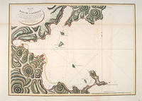
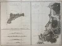
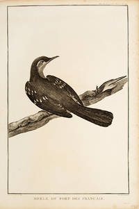
179755881Paris: 1797. From the Voyages of La Pérouse who set sail from France in 1785 to continue the discoveries of Captain Cook. He was shipwrecked in 1788 but his narrative maps and views survived and were published in 1797. Thirty-eight years later the scattered remains of La Boussole and L'Astrolabe was discovered wrecked on a vicious reef on an atoll in the New Hebrides. Attractive sea chart showing the entrance to Port des Français. Engraved by BOUCLET. Atlas Du Voyage De La Pérouse. Size: 680 x 495 mm. Copper engraving. Hand coloured. Fine condition. Good margins. unknown
1788M4779Paris 1788. Very Good. Size : 685x495 mm 27x19.5 Inches Coloring: Hand Colored Category: Maps Russia; Maps Asia Far East Japan & Korea; unknown
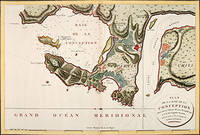
179756362Paris: 1797. Fine sea chart of the bay and Bio Bio River region with great topographical and hydrological detail. Villages and Fort St. Pierre are depicted. From the Voyages of La Pérouse who set sail from France in 1785 to continue the discoveries of Captain Cook. He was shipwrecked in 1788 but his narrative maps and views survived and were published in 1797. Thirty-eight years later the scattered remains of La Boussole and L'Astrolabe was discovered wrecked on a vicious reef on an atoll in the New Hebrides. Copper engraving. Very good condition; slight browning to the centrefold. Hand coloured. Size: 57 x 42 cm. unknown
179755877Atlas Du Voyage De La Pérouse. Paris: L'Imprimerie de la Republique. 1797. From the Voyages of La Pérouse who set sail from France in 1785 to continue the discoveries of Captain Cook. He was shipwrecked in 1788 but his narrative maps and views survived and were published in 1797. An attractive sea chart showing a bay at the coast of Eastern Tartary. Relief shown by hachures; depths by soundings. This is how this part of La Pérouse's journey was described in a diary: 'On 11 August they reached the southwestern point of Sakhalin Island which La Pérouse named Cap Crillon Mys Kril'on. The ships anchored near Mys Kril'on and Vaujuas went ashore where he met more Ainu people some of whom also visited the ship. The ships began to sail through the strait the next day. La Pérouse called it Canal de Castries but it would later be called La Perouse Strait.' Copper engraving. Very good condition. Faint vertical waterstains. Some very slight browning to lower margin. Good margins. Hand coloured. Size: 68 x 49 cm. 27 x 19½ inches unknown
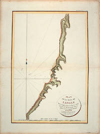
179755866Paris: L'Imprimerie de la Republique.Atlas Du Voyage De La Pérouse. 1797. From the Voyages of La Pérouse who set sail from France in 1785 to continue the discoveries of Captain Cook. He was shipwrecked in 1788 but his narrative maps and views survived and were published in 1797. Tomari Region Russia ; Sakhalin Russia Full Title: Plan de la Baie de Langle. Situee a la partie ouest de l'Ile de Tchoka par 47048'36" de latitude nord et 139057'54" de longitude orientale. L. Aubert scripsit. Atlas du Voyage de la Perouse no. 49. Paris: L'Imprimerie de la Republique An V 1797. Engraved by AUBERTL. Size: 255 x 400 mm. Copper engraving. Hand coloured. Very good condition. unknown
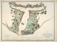
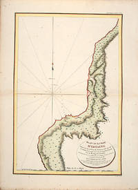
179755865Atlas Du Voyage De La Pérouse. 1797. From the Voyages of La Pérouse who set sail from France in 1785 to continue the discoveries of Captain Cook. He was shipwrecked in 1788 but his narrative maps and views survived and were published in 1797. Uglegorsk Region Russia Full Title: Plan de la Baie d'Estaing. Situee a la cote de l'ouest de Tchoka par 48059'38" de latitude nord et par 14000'42" de longitude orientale prise du mouillage de l'Astrolabe. Cette Baie fut decouverte le 20 juillet 1787 par les Fregates Francaises la Boussole et l'Astrolabe commandees par MM. de La Perouse et de Langle. L. Aubert scripsit. Atlas du Voyage de la Perouse no. 51. Paris: L'Imprimerie de la Republique An V 1797. Engraved by AUBERTL. Size: 255 x 400 mm. Copper engraving. Uncoloured. Very good condition. unknown
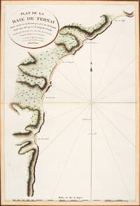
179756364Atlas Du Voyage De La Pérouse. Paris: L'Imprimerie de la Republique. 1797. A crisp clear map of the Bay of Ternai in Tartary. Relief shown by hachures; depths by soundings. From the Voyages of La Pérouse who set sail from France in 1785 to continue the discoveries of Captain Cook. He was shipwrecked in 1788 but his narrative maps and views survived and were published in 1797. Thirty-eight years later the scattered remains of La Boussole and L'Astrolabe was discovered wrecked on a vicious reef on an atoll in the New Hebrides. Copper engraving. Fine condition; slight browning and foxing to wide margins not affecting the image. Hand coloured. Size: 42.5 x 56.5 cm. 16½ x 22 inches unknown
1797299774Paris: L'Imprimerie de la Republique 1797. Map. Engraving with hand coloring. Sheet measures 21 1/4" x 28"<br/> <br/> This chart depicts Easter Island with a close-up of Cook's Bay. Relief is depicted by hachure and elevation is shown from several vantage points. Points and peaks of the elevation views correspond to labels on the map. The Bay shows depths and various structures are labeled. The map appeared as Plate 10 in "Atlas du Voyage de La Perouse." It is in very good condition. Stain to upper margin minor foxing marks.<br> <br> Jean Francois de Galaup 1741-c.1788 was a French Navy officer and explorer known for his travels in Oceania. In 1787 he explored the northeast and mainland Asian coasts in the area of Korea. Other voyages included Alaska Japan Australia and the South Pacific. This map demonstrates some of the many observations and findings made on his journeys.<br/> <br/> L'Imprimerie de la Republique unknown
1797016788Paris: La Perouse 1797. Map. Very good condition. Unbound. First Edition. Folio. A large map beautifully decorated with original outline color. The map is included in the Atlas volume of La Perouse's Voyages but was drawn from Spanish manuscripts as it was thought that it might be a part of the Northwest Passage. The map has an extra vertical crease from mis-folding but is quite clean and has large margins which are lightly soiled here and there. La Perouse Paperback
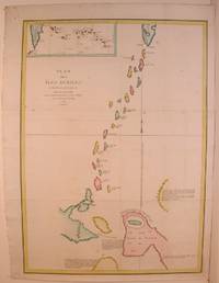
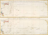
179756361Paris: 1797. An interesting large sheet with two maps covering the same area. The top chart shows the routes of the Spanish galleons from Acapulco to the Philippines. The bottom chart shows La Perouse's route from Monterey through Hawaii and the Marianas to Macao. From the Voyages of La Pérouse who set sail from France in 1785 to continue the discoveries of Captain Cook. He was shipwrecked in 1788 but his narrative maps and views survived and were published in 1797. Thirty-eight years later the scattered remains of La Boussole and L'Astrolabe was discovered wrecked on a vicious reef on an atoll in the New Hebrides. Full title: "Partie de la Mer du Sud comprise entre les Philippines et la Californie d'apres de Carte Espagnole trouvee sur le Galion pris par l'Amiral Anson en 1743 qui represente l'etat des connaissances a cette epoque et les routes que suivaient ordinairement les Galions dans leur traversee de Manille a Acapulco. Partie de la Mer du Sud comprise entre les Philippines et la California d'apres une autre Carte Espagnole communiquee a La Perouse dans sa relache a Monterey sur laquelle il avait trace sa route ainsi que les Iles qu'il avait reconnues avec des notes sur celles qu'il n'avait pas retrouvee." Copper engraving. Very good condition; some light stains along the lower horizontal fold; a tear and some foxing to the upper margin; wide margins. Hand coloured. Size: 79 x 55.5 cm. unknown
1798496London: G & T Robinson 1798. The English edition of a map published to accompany La Perouse' Voyage. G&T Robinson Nov. 1st 1798. Covers from the Gulf of Carpentaria to the Solitaire Islands to the Navigator Islands in the east and to above New Guinea. Charts Maurelle's tracks. G & T Robinson unknown
62768P., Lecointe, 1832, 4 volumes petit in 12, cartonnage de papiper crème de l'éditeur, 28-179, 212, 198 et 206 pages ; quelques rousseurs ; galeries de vers marginales au Tome II ; cartonnages légèrement fanés.
1844SEG350Paris Comptoir des Imprimeurs Unis 1844 Grands In8 - Demi-chagrins d'époque - dos à nerfs ornés - Frottements sur certains mors et coiffes sans gravité - Complet des 5 grandes cartes dépliantes rehaussées en couleurs et des 100 gravures hors texte sur acier - Rousseurs éparses particulièrement aux Tomes 1 & 2 .Belle condition Tome 1 : 1845 - 363 pages - 1 carte dépliante de l'Océanie - Voyages de George Anson , de Bougainville et du Cpt Byron Tome 2 : Sd , 393 pages - Voyages de Cook Tome 3 : 1844 - 403 pages - Voyages de Cook Tome 4 : 1844 - 396 pages - Voyages de Cook Tome 5 : 1844 - 396 pages - voyages de Cook Tome 6 : 1844 - 388 pages - Voyage de La Pérouse , du Cpt Baudin , de Freycinet et de Dumont d'Urville Tome 7 : 1845 - 412 pages - 1 carte dépliante de l'Afrique - Voyages de Bruce Tome 8 : 1845 - 441 pages - Voyage de Le Vaillant Tome 9 : 1845 - 438 pages - Voyage de Mungo-Park , de René Caillié , des frères Lander Tome 10 : 1845 - 439 pages - 1 carte dépliante de l'Asie - Voyage de Chardin , Voyages aux Indes Orientales Tome 11 : 1844 - 412 pages - Voyage de Macartney , de Klaproth , de Niebuhr , Voyage en Arabie , Voyage à Smyrne Tome 12 : 1844 - 400 pages - 2 cartes dépliantes des Amériques - Voyage de Colomb , Voyage de Cortez , Voyage aux Etats Unis , Voyage en Amérique , Voyage en Morée
1844SEG350Paris Comptoir des Imprimeurs Unis 1844 Grands In8 - Demi-chagrins d'époque - dos à nerfs ornés - Frottements sur certains mors et coiffes sans gravité - Complet des 5 grandes cartes dépliantes rehaussées en couleurs et des 100 gravures hors texte sur acier - Rousseurs éparses particulièrement aux Tomes 1 & 2 .Belle condition Tome 1 : 1845 - 363 pages - 1 carte dépliante de l'Océanie - Voyages de George Anson , de Bougainville et du Cpt Byron Tome 2 : Sd , 393 pages - Voyages de Cook Tome 3 : 1844 - 403 pages - Voyages de Cook Tome 4 : 1844 - 396 pages - Voyages de Cook Tome 5 : 1844 - 396 pages - voyages de Cook Tome 6 : 1844 - 388 pages - Voyage de La Pérouse , du Cpt Baudin , de Freycinet et de Dumont d'Urville Tome 7 : 1845 - 412 pages - 1 carte dépliante de l'Afrique - Voyages de Bruce Tome 8 : 1845 - 441 pages - Voyage de Le Vaillant Tome 9 : 1845 - 438 pages - Voyage de Mungo-Park , de René Caillié , des frères Lander Tome 10 : 1845 - 439 pages - 1 carte dépliante de l'Asie - Voyage de Chardin , Voyages aux Indes Orientales Tome 11 : 1844 - 412 pages - Voyage de Macartney , de Klaproth , de Niebuhr , Voyage en Arabie , Voyage à Smyrne Tome 12 : 1844 - 400 pages - 2 cartes dépliantes des Amériques - Voyage de Colomb , Voyage de Cortez , Voyage aux Etats Unis , Voyage en Amérique , Voyage en Morée
0259332135.Gpaperback. Good. Access codes and supplements are not guaranteed with used items. May be an ex-library book. paperback
Il saggio, da lettere inedite, su ISTANBUL, occupa 46 pagine. Il fascicolo in-8° (cm. 21,2x14,1), brossura editoriale (mancanze al dorso, ma ben cucito), contiene inoltre: 1) Tableau historique des DECOUVERTES géographiques des Scandinaves, et spécialement de celle de l'AMERIQUE AVANT Christophe COLOMB. Pp. 37, ma MANCA la carta geogr. fuori testo. 2) Mathieu FLINDERS (comandante della Marina inglese e prigioniero in Francia). Sur le banc du NAUFRAGE et sur le SORT de M. LA PEROUSE. Pp. 21. 3) Recensioni di opere storiche tedesche e dell'Accademia Celtica.
1788M6851Paris 1788. Very Good; laid on acid-free canvas for long-term preservation. Notes: This handsome sea chart depicts magnetic needle readings along various routes in the North Pacific ocean.<br> Size : 590x1090 mm 23.23x42.91 Inches Coloring: Hand Colored in Outline Category: Maps Sea Chart; Maps Ocean Pacific; Maps United States West; unknown
179755672Paris. 1797. Print of an Alaskan Merle Bird. From the Voyages of La Pérouse who set sail from France in 1785 to continue the discoveries of Captain Cook. He was shipwrecked in 1788 but his narrative maps and views survived and were published in 1797. Atlas Du Voyage De La Pérouse. Size: 255 x 400 mm. Copper engraving. Uncoloured. Very good condition. Slight browing around edges but not effecting image. unknown
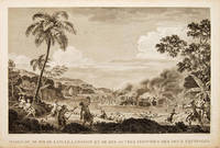
179755648Atlas Du Voyage De La Pérouse. 1797. Scene showing the locals attacking voyagers as they disembark from their boats. From the Voyages of La Pérouse who set sail from France in 1785 to continue the discoveries of Captain Cook. He was shipwrecked in 1788 but his narrative maps and views survived and were published in 1797. Copper engraving. Very good condition. slight browing around edges but not effecting image Uncoloured. Size: 40 x 25.5 cm. 15½ x 10 inches unknown