259 résultats
186161812New York: W. Schaus; printed by Sarony Major & Knapp 1861. Second Edition. 59 x 76cm open. 19.5x19cm closed. Tinted lithographic map backed in brown silk in black slipcase with printed paper label. Bookseller's ticket of Rev. A. O. Brickman Baltimore. Two ownership inscriptions of "J. M. Deems Maj. 1st MD Cav" and inscribed "Deems" on the slipcase. Trimmed; splits along half of one horizontal fold; minor stains and discoloration to verso not affecting image which is bright and generally Very Good. Hand-made slipcase worn with portion cut out but with manuscript ownership label intact. <br /> <br /> Uncommon Civil War map used by a distinguished Union Army officer. James Monroe Deems 1818-1901 was a composer and music educator from Baltimore who secured a commission as a major in 1861. He was promoted to Lieutenant Colonel in spring 1863; led the First Maryland Cavalry during the Battle of Gettysburg; retired due to rheumatism in November 1863; and was brevetted Brigadier General in 1867. He likely acquired this map in Baltimore near the beginning of his military career and certainly before his promotion in 1863 given the use of "Maj." in his ownership inscriptions. <br /> <br /> The map itself is the second edition of this design by J. Schedler despite the title it is not a bird's-eye view. The more common first edition has two insets showing the Lower Mississippi Valley and the city of Richmond see Stephenson 17.3. This version has only one inset showing the eastern United States. Stephenson describes this edition as having a Washington DC bookseller's ticket; the present copy has a Baltimore bookseller's ticket instead. <br /> <br /> This copy was mounted for use in the field: it was trimmed down to the neatline the captions removed the image cut up into segments and mounted on linen. The printed label on the slipcase appears to be a portion of the original title. This may have been done by the bookseller Brickman possibly at Deems' request. <br /> <br /> Uncommon. OCLC records about 10 similarly titled maps but few listings distinguish between the first and second editions. STEPHENSON LC Civil War Maps 2nd ed 17.35. 61812. [W. Schaus; printed by Sarony, Major & Knapp] unknown
1888J4KDIGIVEPWUFrance 1888. Brown and black ink watercolour chalk and gold paint on paper mounted on several laminated sheets of paper 69.5 x 52.5 cm. Charming trompe-l'oeil of maps of European countries on a decorated background somewhat reminiscent of a church ceiling. It contains a French inscription "to my beloved parents" which together with some inconsistencies in the use of perspective suggest a young French artist. The maps show some interesting departures from reality: in the Netherlands parts of the province of Gelderland are shifted 50 kilometres to the north replacing Zwolle with Arnhem and Sweden lacks Stockholm but includes Copenhagen in place of Malmö. However the most humorous is in the map of Germany which lacks its western neighbours - the Netherlands Belgium Luxemburg and France - giving it an extensive North Sea coast. The gothic lettering is inconsistent in style with the artist apparently improvising an alphabet for each inscription in the process forgetting Denmark.Somewhat soiled and browned at the edges with several white spots due to overpainting; the sheets are coming loose from one another. unknown
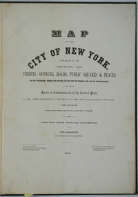
187226020New York 1872. Hardcover. Very good condition. Maps of Manhattan's west side prior to the completion of Central Park which was finished in 1876. The maps were compiled by longtime New York City Department of Public Works map clerk and city surveyor Otto Sackersdorff noted for his 'Maps of Farms Commonly called The Blue Book 1815". The Blue Book was not published until 1868 as a demonstration of northern economic might at the end of the Civil War. <br /> <br /> The real estate maps show property lines existing roads parks shorelines wetlands and the Manhattan grid extending from west of 8th Avenue at 59th Street and Columbus Circle up to 222nd Street and Spuyten Duyvil & Kingsbridge. Parks and major thoroughfares include: Central Park St. Nicholas Avenue Fort Washington Park Kingsbridge Road and High Bridge Park.<br /> <br /> Folio 15 x 20 1/2" 14 maps in total: 1 full page and 13 double page 28 x 20" hand colored lithographed map sheets. Each map contiguous with one another. Period quarter green gilt leather and dark green buckram boards. Spine gently rubbed; the maps exceptionally bright and clean. <br /> <br /> Previous owner inscription in pencil E. B. Van Winkle from Chas. H. Myers July 1875. Van Winkle was a civil engineer with an interest in road construction and drainage having written a report on the drainage of the 23rd & 24th wards of New York City. Myers was an Assistant Engineer in Charge of Sewers for New York City.<br /> <br /> OCLC: 41175506 at Princeton and OCLC: 40671892 at Columbia and the New York Public Library. hardcover
184987523Washington D.C.: Government Printing Office 1849. Hardcover. Very Good. Octavo 9.2 in. x 6 in. pp. 678 1 index. Personal copy with gilt ownership plate to front board of DeWitt C. Lawrence Chief Clerk of the Patent Office. Illustrated with sixteen folding maps. Black half calf with decorative gilt chain rule over marbled boards. Rebacked spine. Gilt name on black ownership panel to front board. Black title on paper panel to spine. Marbled endpapers. Front free endpaper detached but present. Detailed pencil notes presumably from DeWitt Lawrence to preliminary pages index and rear endpapers and to occasional penciled comments on margins of main text providing reference and guidance. Fremont Preuss's maps #II-VIII in VG condition. Other maps in G condition with additional creases a few short closed tears at seams and light browning to several edges. <br /> <br /> ALL16 maps detached as they were removed for preservation and study. Maps I IX-XVI folded in archival pocket. The PREUSS Maps II-VIII "The Rockwell Maps" are laying flat preserved in archival sheath and will be mailed separately under cover. Includes additional copy of Rockwell's map of "Section III". The 16 folded maps include: #I. Map of the Country Between the Atlantic and Pacific Oceans. 1848. Rob Mills. Pencil notes on map. #II-VIII. Road from Missouri to Oregon in 7 Sections 1848. Charles Preuss. Includes two identical copies of Section #III map. All eight Preuss maps in VG condition #IX. Republica Mexicana Plano del Curso del Rio Coatzacoalcos. 1843 #X. Profils en Long et en Traviors du Canal. L'Isthme de Panama1841. Garella. #XI. Profile of That Section of the Country between Nicaragua and the South Sea 1838. Based on Thompson's Guatamala. #XII. Nicaragua Realejo Harbour Edward Belcher Harbour of San Juan de Nicaragua George Peacock 1832 #XIII. Chart of the Bay of Limon or Navy Bay 1829. J.A. Lloyd. #XIV. Republica Mexicana Pano de la Parte Austral del Istmo de Tehuantepec 1843. Jose de Garay. #XV. Panama Canal Longitudinal Section. J.A. Lloyd. Four inch closed tear with 1/2 inch chip to seam. #XVI. Carte Topographique de la Partie De L'Isthme de Panama comprise entre Panama Chagres. 1845. Garella. Uniquely annotated copy. <br /> <br /> The "first major government report devoted to interoceanic communication.Rockwell in addition to his prime focus on Central American canals compiled memorable documents on the suddenly urgent need for more directly binding California to the Union.Foremost.was the matchless seven-section map of the Oregon Trail made by Charles Preuss Fremont's gifted cartographer. Lieut. G.K. Warren in his 1859 memoir wrote that Preuss's 'skill in sketching topography in the field and in representing it on the map has probably never been surpassed in this country.' <br /> <br /> ".The Senate had issued this map separately in 1846; now the House was trying to make available to the Forty-0niners what was by far the best trail map of them all.this treasure was so deeply buried in this report that but few gold seekers found it and it is still so rare in both editions that Wheat lamented that it ' has been insufficiently appreciated by students of Western history.' ." Plains & Rockies 1800-1865: Supplemental volume to the series News of the Plains and Rockies; 2001 Arthur H. Clark Spokane. [Government Printing Office] hardcover
182342750London: T. Cadell and W. Davies 1823. First edition. Hardcover. g to vg. Large quarto 11 1/4 x 9". 2 xxviii xxiii 1 812pp; xix 13 715pp 1pp Errata 2pp Publisher's advertisement; 2 xv 12 20 822pp; 2 xx 14 735pp 1pp Errata; xii 14 763pp 1pp Errata; 2 iv 14 555 1pp. Modern half black morocco over dark grey cloth with gold lettering and ruling to spines. Raised bands. First volume with a striking tissue-guarded frontispiece portrait of the author engraved by Richard Golding after a painting by John Opie. Tissue-guarded engraved frontispiece in each volume.<br /> <br /> First edition of Edward Daniel Clarke's magnum opus "Travels in Various Countries of Europe Asia and Africa" the author's personal account of a fascinating journey throughout three continents. <br /> <br /> Following a tour of Scandinavia in 1799 Edward Daniel Clarke 1769-1822 travelled through Russia and the Crimea before proceeding to Constantinople Rhodes and afterwards Egypt and Palestine. Greece was the country next visited. While touring this country Clarke as a mineralogist and antiquary collected marbles coins and vases and purchased a large ancient statue at Eleusis. From Athens he proceeded by land to Constantinople and after a short stay in that city directed his course homewards through Rumelia Austria Germany and France.<br /> <br /> Each of the six volumes is lavishly illustrated throughout with numerous in-text vignettes and woodcuts as well as full-page copper plates many folded depicting views monuments natives in traditional costume ceremonies and processions antiquities etc. Includes several folded maps and charts. All the 185 copper plates and 157 vignettes and cuts are accounted for.<br /> <br /> Plates engraved by Joseph Skelton R. Pollard Laetitia and Elizabeth Byrne F. R. Hay J. Fittler and R. Cooper after illustrations by E. D. Clarke Angelica Clarke Guarenghi Martin Dreier W. Havell Camporesi J. B. Lusieri Morritt W. Harraden Grelot Fauvel G. Wilkins Henry Wrighte and Preaux. Most of the delightful vignettes were engraved by Elizabeth and Laetitia Byrne. The maps and plans were engraved by S. I. Neele and H. Mutlow.<br /> <br /> Some offsetting to text pages facing plates. Moderate to heavy foxing to plates throughout. Minor foxing to text pages. Sporadic clear water-staining along edges of plates in second volume Part 2 section 1. Ex-library copy with perforating library stamp to each title page and small reference stamp at inner gutter of the first text leaf of each volume not affecting lettering. Bindings in overall very good interior in good to very good condition. T. Cadell and W. Davies hardcover
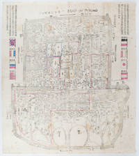
1900169765Circa1900. Large illustrated map of Beijing showing the city in the period following the invasion of the military forces of the Eight National Alliance old folds scale not given. Some scattered light foxing particularly at edges short closed tear at fold lower edge neat non acidic tape repair short section upper edge wear along folds and a couple of small unobtrusive holes with minor image loss. Blocks of text in traditional Chinese right and left upper sections stating each nation's occupied zone Japanese text title accompanies the English title along the upper section of the map. 63.7 x 56.9cm. Very good overall. A rare and significant large Japanese woodblock map of Peking Beijing issued just after the suppression of the Boxer Rebellion. Centred on the Forbidden City the map depicts Peking following the multinational suppression of the Boxer Rebellion or Yihetuan Movement of 1900. The map was issued to illustrate the areas of occupation associated with each of the powers in the Eight Nation Alliance. <br> <br>The map gives measurements of the city walls detailed names of streets and buildings and the boundaries of the inner and outer city including the forbidden city are shown with demarcation lines in pink yellow and blue. The hand coloured eight national flags of the occupation powers are featured at the right and left. <br> <br>This map is essentially a later edition of 京城内外首善全圖 a map of Beijing issued by the Qing for administrative purposes in the mid-19th century. The Japanese seized the wood blocks during the suppression of the Rebellion and subsequently pulled new impressions overprinting them additional details including flags and demarcations of areas of the city held by members of the Alliance. Versions are known in French German Japanese and as with the present example English. An attractive map of great historical interest. . unknown
1838021038London: T. McLean D.& P. Colnaghi and John F. Lewis 1838. 1838. Book. Illus. by John F. Lewis. Near Fine. Hardcover. First Edition. Folio approx. 55 x 36.5cm. Complete with all Lithographic plates as called for; tinted frontispiece tinted title-vignette further 27 tinted views on 25 leaves all by Lewis after Coke Smyth. A very clean bright copy. Finely bound in modern brown morocco to style with gilt lettering to the spine and gilt bands to the top and bottom of the spine. Contents clean and tight new light brown endpapers in keeping with the new binding two blank leaves to the front and rear all pages have been professionally cleaned and restored by a paper conservator minimal and unobtrusive water staining remains to some pages and plates mostly confined to the margins and blank areas most plates unaffected new archival paper guards to all plates no inscriptions. A fine complete copy beautifully rebound. References -. Abbey Travel II 394; Atabey 722; Blackmer 1015; Contominas 413; RIBA 1886. T. McLean, D.& P. Colnaghi and John F. Lewis [1838]. Hardcover
18295146264London, The Trustees of the British Museum 1820-1829. Mit 2 Schabkunst-Porträts und 2 Holzschnitt-Vignetten. Gr.-2° (46 x 33,5 cm). Professionell restaurierte Pappbände der Zeit mit gedruckten Orig.-Papierrückenschildern.