HORN, GeorgAntiquariat.de
[AMERICANA / ATLAS]Biblio.com
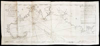
The English Pilot. The Fourth Book. Describing The West-India Navigation from Hudson's Bay to the River Amazones.
17945887<p>THE FIRST ENGLISH SEA ATLAS OF AMERICA</p><p>Folio 47.7 x 31 cm 66 pp. with pagination errors with 26 engraved maps 21 of which are double-page or folding the first chart with letterpress text attached as called for numerous woodcuts in the text. Bound in contemporary sheep rebacked blind-tooled borders to upper and lower covers. Minor rubbing to covers. Some spotting to the fourth map Verner no. 62 and adjacent letterpress pages small tear to fold of map 10 Verner no. 60 two small circular mends to title page not affecting text otherwise remarkably well preserved.</p><p>A spectacular copy of the final edition of the <em>English Pilot</em> <em>The Fourth Book</em> the first wholly English sea atlas of American waters. The work was sufficiently in demand to justify 37 legitimate editions from 1689 to 1794 and three pirated editions. All editions are rare. During the history of this title its charts underwent numerous changes. The first edition contained only 18 maps whereas this 1794 final edition contained 26.</p><p>"<em>The English Pilot</em> was the first major sea-atlas produced in England. In its final form it consisted of five separate books and <em>The Fourth Book</em> was the first wholly English sea-atlas of American waters. Although the idea originated with John Seller he was involved in producing only the first two books. William Fisher and John Thornton produced <em>The Fourth Book</em> in 1689 and their successors Mount and Page continued to print it for over 100 years Seller's proposal for a 'Sea Waggoner' resulted in the production of <em>The English Pilot</em> which consisted of five separate volumes with a common generic title. Book One included the southern navigation and Book Two the northern. Book Three was concerned with the Orient Book Four with America and Book Five contained Africa. Each book or volume has its own independent publishing history and appeared in numerous editions. The five separate books constitute a set only by virtue of the general title and under that title <em>The English Pilot</em> is the first great sea-atlas produced in England. Of the five books the fourth has the longest publication history and is the best known" Verner p. v.</p><p>Throughout its history <em>The Fourth Book</em> showed very few changes in textual matter and the content of the volume was established between the editions of 1706 and 1721.</p><p>The present example of the 1794 edition is complete and contains the following maps see Verner pp. xv-xx for full list of editions and charts from 1689 to 1794:</p><p>1. A New and Correct Chart of the Western and Southern Oceans Showing the Variations of the Compass with letterpress text attached</p><p>2. A New and Correct Chart of the North Part of America from New Found Land to Hudson's Bay</p><p>3. A New Generall Chart for the West Indies of E. Wright's Projection</p><p>4. A New and Accurate Chart of the Vast Atlantic or Western Ocean by Eman. Bowen</p><p>5. Harbour of Casco Bay Capt. Cyprian Southicke 1720 Em. Bowen</p><p>6. A New and Correct Chart of the Coast Line of Newfoundland from Cape Raze to Cape Bionavista</p><p>7. Island of St. Peters </p><p>8. Chart of the South East Coast of Newfoundland</p><p>9. New and Correct Chart of the Sea Coast of New-England from Cape Cod to Casco Bay Henry Barnsley</p><p>10. A Map of the Coast of New England from Staten Island to the Island of Breton Capt. Cyprian Southack</p><p>11. A Chart of New York Harbour with the Banks </p><p>12. Virginia Maryland Pennsylvania East & West New Jersey </p><p>13. A Draught of Virginia by Mark Tiddeman</p><p>14. Barbados copperplate in text</p><p>15. A New Mapp of the Island of St. Christophers Survey taken by Mr. Andrew Norwood</p><p>16. A Large Draft of the Island of Antegua copperplate in the text</p><p>17. A Draught of South Carolina and Georgia from Sewee to St. Estaca by Andrew Hughes</p><p>18. A Correct Chart of the Caribee Islands</p><p>19. A Correct Chart of Hispaniola with the Windward Passage by C. Price</p><p>20. A Draught of the West End of the Island of Porto Rico </p><p>21. A New & Correct Chart of Cuba Streights of Bahama Windward Passage </p><p>22. A New and Correct Draught of the Bay of Matanzas by Rob.t Pearson</p><p>23. Bermudas copperplate in text</p><p>24. A New and Correct Chart of the Island of Jamaica</p><p>25. A Chart of the Coast of Guayana By R. Waddington</p><p>26. A New and Correct Chart of the Trading Part of the West Indies</p><p> <em>The English Pilot: The Fourth Book</em> Amsterdam 1967 with an introduction by Coolie Verner.</p> Printed for Mount and Davidson hardcover
Martayan Lan, Inc. · États-Unis22 500,00 $US≈ 19 037,25 €
