Allan W Atlas,Biblio.com

990 résultats
5746545-nnew. unknown
5746545like new. unknown
B9780521088305Paperback / softback. New. This book deals with various aspects of musical life at the Aragonese court of Naples from its establishment in 1442 to its demise in the opening years of the sixteenth century. paperback
6414962Cambridge University Press CUP pp. 284 . Papeback. New. Cambridge University Press CUP unknown
19762859.1973<p>1976 Institute of Mediaeval Music hardcover; no dust jacket; lightcover wear; pages clean/tight; good condition</p> Institute of Mediaeval Music hardcover
1849azgsWilliam Blackwood and Sons Edinburgh and London 1849. 5th or later Edition. Hardcover. Very Good/No Jacket. 14 volumes plus atlas complete. All fully bound in leather with gilt decoration - to fascias spines and edges - and titling. All have marbled papertrims and frontis and end papers. This is a FABULOUS set of this popular loquacious history of Europe with the first major account of the French Revolution. It is smart handsome gentlemanly and very clubbable. Some of the books have wear from shelving and are scuffed but this only adds a genial dignity and character. All have binder labels T. Sowler Manchester - the very model of a Victorian businessman on the front pastedowns. Spines have five ridges and six panels. The Atlas 108 pages - published 1850 contains maps of countries and towns and plans of 'battles and sieges &c.' The covers are worn and scuffed. Within there are some small storage marks about. The pages are clean startlingly bright and clear finely detailed and the colours for various regiments fresh. Volume 1 633 pgs; 1849: wear to edges and spine but dignified and secure. The contents are tight and clean. Covers 1774-1789. Vol 2 693 pgs; 1849. In very good handsome condition. Light wear bright gilt. Inside the contents are clean and fresh. There is a silk bookmark. 1789 - 1793. Vol 3 635 pgs; 1749. The stamped decoration as with all other volumes is neat and unworn. The spine has some wear but is benign and kindly. The pages are clean and comfortable. Covers 1795. Vol. 4 654 pages; 1849. A lovely atmospheric copy. At last the story moves on beyond France. The pages are fresh. 1795-1799. Vol V 658 pgs. Neat contented bright. 1799 -1801. Vol 6 670 pgs. Nelson Pitt Napoleon! The odd storage stain. Otherwise very clean. 1801-05. Vol 7 690 pgs. Some age related marks. Tidy and handsome. Fox Prussia Clive of India! 1805-07. Vol 8 696 pgs. Tight confident clean. Some cover wear. Wellesley Napoleon Peninsula Wars. 1807-09. Vol 9. A happy book. Some wear. Spain George III! Pages exceptional. Vol. 10 630 pgs. Some scuffing and wear. Wellington the Emperor South America Turks Russians! Pages very clean. 1810-12. Vol 11 637 pgs. Some wear to the covers. Contents are smart. Moscow Germany Generals! 1812-13. Vol 12 640 pgs. Confident benign copy with some spine wear. Pages very secure and certain. Wellington in France Blucher Napoleon on the run. 1813-14. Vol 13 664 pgs. Edge and spine wear. Pages vigorous and healthy. Come-uppances America Vienna decides! 1814-1815 1814 is the date when Alison had the idea of this history. Vol 14 644 pgs. Some aged wear to the covers. The pages are startlingly healthy. Waterloo St Helena The First Reform Bill contemporary judgements. 1815 and index. Oh happy person who owns this THRILLING story as told in these wonderful and REMARKABLE volumes. fk. Our orders are shipped using tracked courier delivery services. William Blackwood and Sons, Edinburgh and London hardcover
1334032505.Gpaperback. Good. Access codes and supplements are not guaranteed with used items. May be an ex-library book. paperback
1527749126.Gpaperback. Good. Access codes and supplements are not guaranteed with used items. May be an ex-library book. paperback
0366091522.Gpaperback. Good. Access codes and supplements are not guaranteed with used items. May be an ex-library book. paperback
1332772846.Gpaperback. Good. Access codes and supplements are not guaranteed with used items. May be an ex-library book. paperback
1790D19541London 1790. Twelfth Edition. Hardcover. Very Good. Thick quarto. 22 engraved maps after Thomas Kitchin georgrapher to the King. A colorful hodgepodge of a binding with parts contemporary and other bits newer. Contents typically toned. <br/><br/> hardcover
188162541Neillsville & Wasau WI: Bussell & Holway Civil Engineers 1881. 8vo. 180 pp unpaginated. with double-page engraved title plat maps throughout primarily on facing recto & verso of leaves while some are overlapping and on next blank continuing w/ laid-in Township Range Plat Map MS on form 4-590 demarcating Government Land and dated March 6 1895 inserted into rear pocket annotations demarcating plat changes red ink markings of “Government Land†w/ V’s and other annotations on several of the maps in Marathon County by former real estate land surveyor. Contemporary black calf rebacked hinges restored w/ thumbing some edgewear still a VG- copy. First edition of this detailed and compact pocket plat map atlas issued by Bussell b. 1854 was a surveyor/civil engineer based out of nearby Neillsville Clark WI and his partner Holway for lands platted through Marathon County Wisconsin in the 19th-Century as the centrally located County opened for logging and settlement on lands driven by the Wisconsin Central Railroad and the Wisconsin Valley Railroad later the Wisconsin Valley Land Company. This exceptional reference provides names of all the original homesteaders and plat-holders as of the time of publication as well as demarcating houses churches schools mills U.S. Government lands state lands as well as the lines for the Lake Shore Traffic Co. Dundee Land Co. and development lands of the C.P. Haseltine Co. Worldcat locates only 1 physical copy at Library of Congress Wisconsin Historical Society does have a scanned searchable copy available online; See: Louise Marchetti History of Marathon County Wisconsin and Representative Citizens 1913. Bussell & Holway, Civil Engineers, unknown
1831D19539Karlsruhe: Verlag Von Gottlieb Braun 1831. Neue Ausgabe. Hardcover. Good. Two volumes bound in one. Oblong with cloth spine and corners marbled paper boards printed label to upper board. 45 21 & 24 hand-colored lithographed maps some folding. Rubbing and wear to boards spotting throughout but hardly untypical. A rather scarce student atlas. <br/><br/> Verlag Von Gottlieb Braun hardcover
194764270Portland OR: Oregon Blue Print Co. 1947-1959. Oblong atlas folio. 21 x 17.5 in. 52 leaves not contiguously numbered. all dyazo-print whjteprint maps w/ first consisting of a large folding “Oswego Oregon Street Map†many leaves w/ creasing corners worn some with closed tears secured at gutter margin w/ 4 brass split-pins over thick brown paper stock still a VG- exemplar. First edition thus of this exceedingly rare realty atlas for Oswego Oregon chronicling its’ explosive growth following World War II prior to the consolidation with surrounding suburbs and renaming as the City of Lake Oswego in 1960. These real estate atlases were sold in installments to Lake Oswego & Portland area real estate agents land use boards and public institutions with installments appearing from 1947-1959 but the Oswego atlas sheets are far scarcer than even the very rare Portland issues. Oswego and surrounding suburbs such as Alto Park Acres Forest Hills Lake Grove Rainbow Terrace Uplands Crest and Woodmont were all developed initially by the Ladd Estate Company which first platted the area with Paul C. Murphy overseeing the design with the aid of of Frederick & John Olmsted to create a park like setting around the Lake. This atlas with key map opening details the evolution from 1947-1959 the street-by-street and plat-by-plat of the surrounding area providing essential information on the emergence of these suburbs from the original donation land claims as the city grew from about 1500 to over 10000 by 1959. The more than 100 new residential plats created from the original donation land claims throughout the Lake Oswego area including the plats on the south side of South Shore Drive which created the Palisades Neighborhood and just prior to the July 2 1959 annexation which brought all of Oswego Lake parts of Lake Grove Palisades and others in the Lake Grove Sanitary District all evolve through these maps. Researchers can trace the evolution of the Portland-Salem Expressway later called the Baldock Freeway and further developed into the I-5 corridor alongside Lake Oswego along with the rapid growth of the area. Original Donation Land Claims are clearly demarcated including those of Charles Brown Bryant Waters Carman Albert Durham and many others. Oregon Blue Print Co. was established on SE Hawthorne in Portland OR by the early 1940’s and were the printers for the Pittmon maps which were extensively used and continually updated in the Portland area. Under Walter & Min Underwood the company focused on blueprinting and engineering plans as well as land promotion brochures and street maps. Company still remains family owned. It appears that later versions of the Oswego Oregon Street Map were used as land promotion brochures and some early versions do survive in holdings of Lake Oswego City Government and 1 in OHS but no other examples are located in Worldcat. No similar versions of this atlas have survived in institutional holdings that this cataloguer could identify accurately. See: Mid-Century Lake Oswego: A Look at Lake Oswego’s Modern Developments 1935-1965 August 2010. Oregon Blue Print Co., hardcover
190953081Seattle & Berkeley CA: Ellis A. Davis 1909. Folio. 190 pp. Illust. & decorated title 100s of photo illusts. over 100 colour maps many double page 1 very large folding colour map tipped-in on rear pastedown a couple minor closed tears at creases. Red cloth silver lettering & decoration embossed on front cover minor bumping to corners bumping & minor fraying head & foot of spine very faint tidemark to fore-edges still a VG- copy very clean and bright textblock. First edition of this well-illustrated commercial atlas intended to promote the Pacific Northwest during the Alaska-Yukon Exposition carefully listing most of the major and minor cities their counties industries local products and 100s of photos of buildings logging railroads shipping and more. The atlas includes detailed economic statistical maps of Oregon Washington and Idaho; street maps of Spokane WA Portland OR Seattle WA Boise ID and more. The large folding colour map at rear is of Oregon State -- these atlases were also issued with Idaho Washington and Oregon & Washington colour maps separately. Ellis A. Davis, hardcover
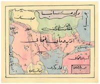
1910ABC_47241Ottoman Empire 1910. Gold-stamped cloth with the tughra of Mehmed V ruled 1908-18 on the front board when reading right to left and "Album" on the back board the front when reading left to right with an inscription below the tughra and the European numerals 16 and 2 flanking an ornament below the inscription the whole framed by 4 large floral cornerpieces. Oblong 4to 26.5 x 19.5 cm. 14 leaves with 10 pen-and-ink maps hand coloured with watercolours. Tissue guards. An album of hand-drawn maps forming an atlas of the western mostly European parts of the Ottoman Empire with legends in Ottoman Turkish written in the Arabic script. The overview map shows Albania Kosovo Macedonia and the Ottoman controlled northern parts of Greece coloured together with Thrace and the northwest parts of Anatolia shown treating them as a single unit while Serbia and Bulgaria like the small parts of territories outside Ottoman control are coloured separately. Most of the other maps give more detailed views of some of these regions including the Bosporus the Dardanelles Halkidiki Chalcidice Albania etc. but there is also a map of Crete not in the overview map.In fine condition. hardcover
195059129Portland OR: Multnomah County Assessor’s Office ca. 1950. Oblong folio. 21 x 13.5 in. 1 1-71 74 leaves as issued. Including Multnomah County key map w/ 73 whiteprint diazo process maps all w/ borders key map w/ small closed tear at lower fore-edge w/ ghosting from old removed scotch tape now neatly repaired on verso. Original black cloth post-binder gilt lettering stamped on front cover 3 nickel-plates screwposts at gutter margin minor rubbing still VG copy. First edition thus of this exceedingly scarce plat map atlas for Multnomah County Oregon surveyed and issued after the famed May 30 1948 Memorial Day flood destroyed Vanport the Wartime Housing Authority of Portland project still existing following V-J Day 3 years earlier. The Vanport community housed the majority of African-American residents in Oregon who were prevented through racist real estate covenants and local ordinances from moving elsewhere prior to the flood and afterwards 1000’s were confined to the Albina area of North Portland. In addition the ongoing highway project for Highway 99 or the Pacific Highway is still demarcated without reference to I-5 which after the 1956 Highway Act would eventually serve to sever North Portland and eliminate entire neighborhoods when later completed. These maps offer an essential snapshot of development in Post-War Portland and guide to neighborhoods and land developments radically changed by expansion of the Portland Airport Interstate Construction and more. Worldcat locates 1 copy OR Hist. Soc. Lib. incorrect collation. Multnomah County Assessor’s Office, hardcover
192955692Portland OR & Tacoma WA: Metsker the Map Man 1929. Oblong atlas folio. 18 x 14.5 in. 45 leaves cyanotype blueprints. Including 44 detailed blueprint plat maps consistently dated 1929 1 large folding key map sized 24.5 x 14.25 in. Publisher’s flexible simulated calf post-binder gilt lettering title stamped on front cover burgundy-coloured silk more pastedowns neat typed label affixed to upper fore-edge of spine minor rubbing shelfwear NF copy. First edition thus of this exceedingly scarce Marion County Metsker plat map atlas providing invaluable historical and genealogical data for 1920s Salem Turner Silverton Stayton and as far north as the area around Aurora Oregon. The index provides specific names and locations for Donation Land Claims Fruit Farms and Tracts including logging and sawmill tracts as well as cities towns and suburban additions. Metsker 1881-1966 civil engineer and mapmaker began working as a teenager with his father in a Winlock WA sawmill by 1900 and later by 1910 ahd become a draftsman in an engineering office in Tacoma WA followed during the next 15 years by stints at engineering firms in Seattle Tacoma and Portland before striking out on his own as a mapmaker surveyor and mapmaker during the Roaring 20s. Metsker’s maps were sold by subscription and updated on an ongoing basis so the subscribers were supposed to throw out the earlier versions of the maps and replace them in the succeeding decades. They all received heavy use and the earliest versions created in the 1920s and 1930s are by far the scarcest of the atlases produced by the firm. Worldcat locates 3 copies of the 1929 Multnomah County Library OHS State Library of Oregon. Metsker the Map Man, unknown
187961342Chicago: J.H. Beers & Co. Publishers Lakeside Building Cr. of Clarks & Adams 1879. Atlas folio. 15 x 17.5 in. 82 pp fairly continuous pagination including maps & lithographs. With 39 hand-coloured lithographed maps several double-page Indiana United States World Columbus Township Columbus Plat Sand Creek & Wayne numerous lithographed plates some large double-page tables charts. Quarter-sheep over black embossed publisher’s cloth gilt lettering stamped on front cover borders embossed in blind wear & bumping to corners some chipping head & foot of spine some wear to fore-edges somewhat shaken still a G copy. First edition of this uncommon original 19th-Century plat map atlas for Bartholomew County Indiana during the Gilded Age. J.H. Beers specialized in County Plat Map atlases and histories from 1878-1900 and also focused on producing municipal history and biographical history titles primarily in and around the Midwest. Their well-executed lithograph birds-eye views of businesses towns family farms and more were quite popular were generally pre-sold through subscription and prosperous towns businesses and farms who paid extra were able to secure a biographical section or view within the volumes. Bartholomew County located about 40 miles south of Indianapolis was originally established in 1821 and named for Lt. Col. Joseph Bartholomew a militia officer wounded at the battle of Tippecanoe. The County featured such companies as the Reeves Pulley Co. Ceraline Manufacturing Orinoco Furniture and others in the 19th Century and as of this publication the population was about 30000 inhabitants and today the County features approximately 82000 inhabitants. The atlas was later reprinted in 1969 1979 and 1986 in very poor smaller reproductions. J.H. Beers & Co., Publishers, Lakeside Building Cr. of Clarks & Adams, hardcover
190763122Chicago & New York: George F. Cram 55-61 Market Street 1907. Folio. 12.25 x 15 in. 160 pp. Illustrated title in blue. Over 100 photo illustrations maps colour maps many double-page with Cram’s Kansas 51.5 x 31.5 inch map in full colour laid-in minor soiling faint markings from glue offsetting where previously attached to rear pastedown. Dark forest-green coloured publisher’s cloth silver lettering & decoration embossed on front cover minor soiling minor wear to corners slight bumping head & foot of spine light restoration back cover still a VG- copy. First edition of this rare Cram’s reference atlas replete with colour World maps and maps of the individual states and many different local cities including Omaha Minneapolis St. Paul St. Louis Chicago and others. The section on Kansas includes two colour maps depicting manufacturing and mechanical industries by counties as well as statistical map showing live stock and dairy products. The photos depict the Kansas oil fields brick yards in Pittsburg KS; oil tank farms in Neodesha Strawboard Factory in Coffeyville streets in Atchison and other areas across the state. The atlas is also unusually complete with the very scarce giant oversize colour Kansas map typically missing from these Cram’s local history reference atlases. George F. Cram, 55-61 Market Street, hardcover
1837891931837. JAPANESE ATLAS Ichikawa Tokei. KOKUGUN ZENZU 2 volumes. Nagoya Edo Osaka Kyoto. Eirakuya Toshiro et al. Preface dated 1837. String-bound Japanese-style fukuro-toji printed paper title labels. Original yellow covers. Covers are a bit soiled with ownership labels. Internal occasional marginal worming. Printed in color woodblock throughout an interesting atlas of the traditional governing divisions of Edo-era Japan. unknown
189056329Yamada Village Japan: n.p. ca. 1890. 4to. 7.5 x 11 in. 354 pp index maps & sections separately paginated. entirely in original manuscript with over 250 plat and section maps many double-page some folding many w/ additions tipped-in or laid-in as supplemental overlays and many w/ additional manuscript annotations most hand-coloured throughout. Original beige limp boards punch-sewn at gutter margin title in manuscript on front cover some scuffing wear occasional internal worming mildly affecting some maps still a VG- exemplar. An extraordinary Meiji-era manuscript real estate plat map atlas for the Yamada Village and environs of the Keta District in present-day northern Hyogo Prefecture. Traditionally ruled over by descendants of the Miwabe-no-Atai clan this real estate atlas volume encompasses hundreds of plat maps tied to outline maps with the plats all numbered and many colour-coded with colour coding to the opening index. The creator of this map atlas appears to have been commissioned by local land agents following the economic expansion after the opening of the Hyogo Harbor in 1867 for foreign trade while quickly became one of the largest trading ports in Japan. The Tajima province is perhaps best known as the birthplace of Kobe Beef or Tajima Wagyu traditionally compact working cattle with a calm nature but which quickly came into high demand as Kobe Beef in the late 1880s as the large foreign trading and tourist community desired beef and the Tajima cattle were especially desired. This also contributed to a rising demand for land in which to raise the Tajima Wagyu cattle and land prices. At the same time the nearby coast also began slowly developing a small tourist trade and coastal resorts. The map sections include No. 5 -- Kitakami no machi; No. 11 -- Sampo no matsu; No. 12 - Shita takimiya; No. 13 - Okawahara; No. 14 - Takimiya; No. 30 - Kita shitaya as well as No. 36 - Kawahara. In April 1896 the Keta District was dissolved and merged into the Kinosaki District along with the Mikumi District and became the Hyogo Prefecture anchored by the city of Kobe. The additional supplemental pieces tipped-in others laid-in and the many add-ons to the folding map with many bearing annotations indicate that this was a meticulously maintained working document for Meiji land agents. We have been unable to locate any similar manuscript or printed real estate atlases for this era and geographical location. See: Mochizuki Kotaro Japan To-Day: A Souvenir of the Anglo-Japanese Exhibition Held in London 1910 Special Number of the “Japan Financial and Economic Monthly;†Mike Buchanan Hyogo Prefecture Tajima Wagyu History Australian Wagyu Forum 2018; Masanobu Suzuki Development and Dispersal Process of Ancient Japanese Clans 2003. [n.p.], hardcover
187354200Chicago IL: Warner & Beers 62 & 64 Lake Street 1873. Atlas folio. 16 x 18.7 in. 3 3 5-91 1 pp. Woodcut-engraved title page 42 hand-coloured steel-engraved maps all w/ nicely executed engraved borders couple double-page additional steel-engraved “Family Records†page filled-out in manuscript inserted. Original front panel stamped in decorative gilt lettering mounted on recent black cloth binding occasional edgewear minor soiling to fore-edges of textblock couple very minor closed tears still VG copy from the library of John Inkster 1828-1908 Scottish-American farmer who immigrated in 1860 to Pilot Township Kankakee IL to farm with his brother James and then continued West to farm in Coast Fork Lane Co. Oregon and finally the Washington Territory in 1881 where he homesteaded near Davenport WT assisted in building Fort Spokane and served as County Commissioner from 1886-1892. First edition of this exceedingly scarce Illinois Atlas published just after the great Chicago Fire of 1871 featuring an unrecorded platt map of Pilot Township in Kankakee County Illinois showing all the properties and property owners in 1872. This atlas also features the Railway map of Illinois City Map of Chicago maps of all the Illinois Counties and large map of the United States. Of special interest are the excellent early western maps of Texas; Minnesota Nebraska and the Dakota Territory; Wyoming Montana and Idaho Territories; Nevada and California along with map of Oregon and Washington and Alaska Territories. The Beers and Warners were successful map publishers in Chicago IL from about 1850 to 1886 and often publishing as Warner & Beers the cartographers produced a series of early state and county atlases and regional maps which were considered the most detailed maps produced at the time of the respective regions. As their Township and County maps often detailed individual homes and landowners they provide invaluable reference tools to researchers historians and genealogists. No copies located of this specific Warner & Beers Atlas in Worldcat; No individual copies located of the Pilot Township Map; See: Portrait & Biographical Record of Kankakee County Illinois 1893 pp. 390-391; An Illustrated History of the Big Bend Country embracing Lincoln Douglas Adams & Franklin Counties 1904 pp. 421-425. Warner & Beers, 62 & 64 Lake Street, hardcover
1780D19540Lyon: Chez Bernuset 1780. Hardcover. Very Good. Nouvelle Edition revue corrigee & augmentee. Contemporary calf. 515 pp. 17 maps. <br/><br/> Chez Bernuset hardcover
1865291807New York: J. H. Colton 1865. Second Edition. Colored engraved map with a bit of creasing at the fold. 11 3/4 x 9 1/2â€. From the second edition of Colton’s Condensed Octavo Atlas of the Union. J. H. Colton unknown