SPRUNER, KARL AND MENKE,THEODORBiblio.com
190 résultats
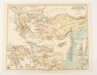
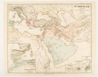
1877174916Gotha: Justus Perthes. 1877. Map with original colour and outline hand-colour 33.1 x 40.2 cm four inset maps text in German central fold slight marginal edge wear and spotting to the verso but in very good condition. A handsome map detailing the lands of Islam from Hegra in AD 622 to the fall of the Umayyads in AD 750. The inset maps depict a western extension to the main map and city plans for Damascus Jathrib & Medina and Mecca issued for the "Hand-Atlas für die Geschichte des Mittelatters und die Neueren Zeit". . Justus Perthes unknown
1876174910Gotha: Justus Perthes. 1876. Map with original colour and outline hand-colour 32.2 x 40 cm seven inset maps text in German central fold slight marginal toning in very good condition. A most handsome and highly detailed map detailing provinces of the Latin Empire in the wake of the Crusades. The inset maps depict Achaia in Greece Divisions of the Empire and a city plan of Constantinople issued for the "Hand-Atlas für die Geschichte des Mittelatters und die Neueren Zeit" . Justus Perthes unknown
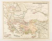
1877174915Gotha: Justus Perthes. 1877. Map with original colour and outline hand-colour 32.2 x 40 cm two inset maps text in German central fold in very good condition. A most handsome map detailing countries on the Aegean and Black Seas 1311 to 1390. The inset maps depict the kingdom of Stephan Duschan Serbia and the land of the Crimean Goths issued for the "Hand-Atlas für die Geschichte des Mittelatters und die Neueren Zeit". . Justus Perthes unknown
1855173439Gotha.: Perthes Justus. Circa1855. Engraved map 44.1 x 36.3 cm sheet size 35.8 x 29.7cm map size plate mark map with original hand colouring and hand coloured key noting Islamic "Mohammedanische" Buddhist "Buddhaistische" and European territories by country. Unusual map in an early issue. It was included as map 39 in Stieler's "Hand-Atlas uber alle Theile der Erde und uber das Weltgebaude by Frederic von Stulpnagel" revised by Hermann Berghaus in 1855. The issue is noted to the top right: Ausg. in 63BI. no XIV. Fine outline hand colouring denotes territories by religion and Chinese ports open to European trade and Japanese ports open to American trade. . Perthes, Justus. unknown
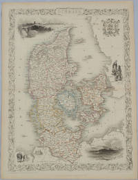
1850175779London & New York.: John Tallis & Company. Circa1850s. Lithographed map with original outline hand colour 34.5 x 24.7 cm including border and captionsfive fine vignette illustrations decorative border central fold edges with light toning in very good condition. Attractive decorative map with fine vignettes of Copenhagen Sleswig and Elsinore figures in costume the coat of arms of Denmark and an amiable equine pair by the great mapmaker and publisher John Tallis. . John Tallis & Company. unknown
185275654Buffalo:: Jewett Thomas & Co. 1852. First edition. original gilt-lettered cloth. Tear to the folding map neatly repaired on verso with Japanese tissue; slight use and fading to the cloth; very attractive. 12mo. Illustrated with maps and numerous engravings from original sketches including a folding map of the "Northern Route U. S. Mail Line.Steamers.New York and Rochester.and Routes from Albany to Niagara Falls Buffalo and Montreal" with inset view of Niagara Falls. Jewett, Thomas & Co., hardcover
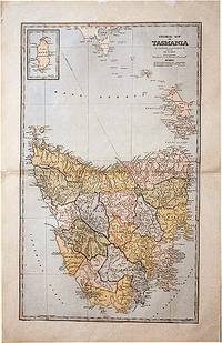
188861874Sydney.: The Picturesque Atlas Publishing Company. 1888. A large and detailed map of Tasmania from The Picturesque Atlas Publishing Company showing railroads existing as well as under construction and coloured regions dividing the island into districts. Hachures depict landforms detailed index to place names on verso small inset upper left corner showing Kind Island printed colour 70 x 45.5 cm. . The Picturesque Atlas Publishing Company. unknown
1890H22859Battle Creek MI: Wm. C. Gage & Son 1890. Paperback. Very Good. Stated Third Edition Revised. 8.25 x 5.5 inches gray printed wraps very good contents tanning. 108 pp full page map on inside front cover no other illustrations. A more substantial 264 pp. version seems also to have been issued interspersed with many ads. This promotional pamphlet is rarer. Wm. C. Gage & Son paperback
180819195Bern, Stämpfli et J. J. Burgdorfer, 1808. In-8 de 48 pages, cartonnage de papier marbré.
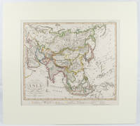
1830175250London.: Society for the Diffusion of Useful Knowledge. Baldwin & Cradock. 1830. Engraved map wth outline hand colour 29.7 x 42 cm relief shown in hachures key to abbreviations including "Ancient Ruins" the west and east extremities attactively engraved to burst through the border original folds map with occasional spotting more pronounced at the lower corner edges a little ragged small chip to the inner margin no loss to the map manuscript pagination in the lower corner but in good condition. . Society for the Diffusion of Useful Knowledge. Baldwin & Cradock. unknown
1893175715New York.: Hunt & Eaton. Circa1893. Printed colour map 24 x 28 cm four thumbnail inset maps: Banana; Boma; Matadi & Environs; Stanley Pool named for the explorer; and below a lozenge inset of the road from Matadi to Leopoldville marginal toning and small edge tears one corner creased but in very good condition and on the verso explanatory text and line engravings in two columns for this map and partial description for the previous entry for the Suez Canal from Hunt & Eaton's school atlas published in 1893. . (Hunt & Eaton). unknown
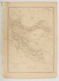
1863177017London.: Cassell Petter and Galpin. circa1863. Engraved map 43.1 x 30.3 cm 50.7 x 34.5 cm sheet central fold small edge tears one neatly repaired lower corner chipped slight age toning but in very good condition. Impressive large map of Persia Iran by noted map maker Edward Weller in original uncoloured state re-issued by the publisher for inclusion as map 26 in Cassell's Atlas. . Cassell, Petter and Galpin. unknown
1836016450Boston: Dutton & Wentworth Printers 1836. Book. Very good condition. Hardcover. First Edition. Octavo 8vo. A bound volume containing a collection of ten publications relating to the Western Rail-Road Corporation from the incorporation in 1836 to 1840. The First Annual Report from 1836 is included twice. Bound in contemporary original three quarter leather which is moderately to heavily worn with the front board nearly detached. There is minor to moderate foxing and the final half of the text is lightly stained at the top corner. The 1836-37 Reports of the Engineers is complete with two fold-out maps which were printed on very thin onion-skin paper. These two maps have been detached and are misfolded with minor tearing as well as some foxing. A ready-made collection of the founding documents of this railroad company which starts in Boston winding its way across the state where it enters New York State at West Stockbridge. Dutton & Wentworth, Printers Hardcover books
185130464Portland ME: Printed by Order of the Directors 1851. 64pp stitched. Wrappers absent else Very Good. <br /> <br /> A.P. Robinson was removed from the office of Chief Engineer of the York and Cumberland Rail Road Company in May 1851; F.O.J. Smith was removed as President in August. Each was removed after discovery of financial discrepancies. Smith retaliated with a pamphlet assailing the Board's conduct. This Statement by the Board thoroughly explains the reasons for his dismissal with detailed lists of costs and estimates and reports from Board meetings. Page 29 begins the thirty-page "Reply" to Smith's pamphlet by Daniel Emery of the Company's Treasury Office. He elaborates on the facts which led to Robinson's and Smith's dismissals. <br /> Sabin 82569. BRE 280. OCLC 13636503 9 as of August 2013. Printed by Order of the Directors unknown
185130464Portland ME: Printed by Order of the Directors 1851. 64pp stitched. Wrappers absent else Very Good. <br/><br/> A.P. Robinson was removed from the office of Chief Engineer of the York and Cumberland Rail Road Company in May 1851; F.O.J. Smith was removed as President in August. Each was removed after discovery of financial discrepancies. Smith retaliated with a pamphlet assailing the Board's conduct. This Statement by the Board thoroughly explains the reasons for his dismissal with detailed lists of costs and estimates and reports from Board meetings. Page 29 begins the thirty-page "Reply" to Smith's pamphlet by Daniel Emery of the Company's Treasury Office. He elaborates on the facts which led to Robinson's and Smith's dismissals. <br/>Sabin 82569. BRE 280. OCLC 13636503 9 as of August 2013. Printed by Order of the Directors unknown books