Livre Rare Book

190 résultats
1811SPN-782Paris : Imprimerie impériale, s.d. [1811]. Brochure de 16 pages en feuilles (113-128).
1823SPN-781Paris : Imprimerie royale, 23 mai 1823. Brochure de 16 pages en feuilles (433-448).
188830736Chicago: The J. M. W. Jones Stationery and Printing Co 1888. 1st edition. Original pictorial wrappers. Some chipping to paper at spine ends with front wrapper starting to detach. Nevertheless a VG copy. 98 pp. Illustrated. 7-3/4" x 5-1/4" <br/><br/> The J. M. W. Jones Stationery and Printing Co unknown books
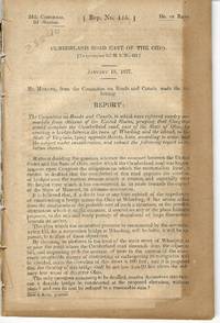
183016204Washington: Other. Very Good. 1830. Hardcover. Disbound; 17; 17 pages light foxing; backstrip splitting; charts and tables and reports regarding construction of the Cumberland Road; Good . Other hardcover books
19002097933[Edinburgh & London: Gall & Inglis ca. 1900]. 848, 23, (5) Seiten. Dünndruckpapier / Bible paper. Mit zahlreichen Karten im Text sowie einer großen Faltkarte im Anhang. Kl. 8° (16 x 9 cm) Orig.-Lederband mit goldgeprägtem Rückentitel und goldgeprägter Deckelvignette (KFZ / automobile). [Hardcover / fest gebunden].
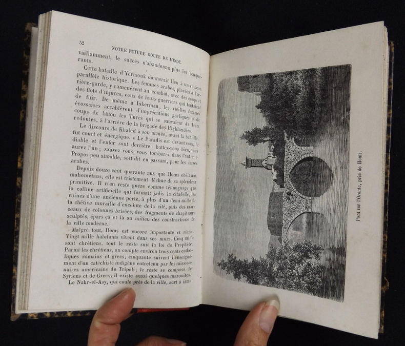
1883pq2305Librairie Hachette et Cie Relié 1883 In-8 (17.5 x 11.5 cm.), relié demi-toile rouge grainée, 269 pages, 29 illustrations en noir et blanc (gravures sur bois), gouttière tachetée ; coin supérieur découpé sur la page de faux-titres, dos légèrement insolé et incurvé, bords inférieurs frottés, quelques traces d'usage aux plats, intérieur frais, bon état. Livraison a domicile (La Poste) ou en Mondial Relay sur simple demande.
1898203128Wien, Luksch, 1898. 96 Seiten. Mit 49 Illustrationen. 20 cm. Originalbroschur.
185830160Lyon Scheuring ( Imprimerie Louis Perrin ) 1858 In-8 108 pp
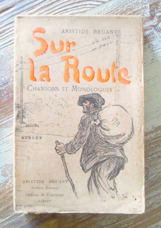
189733510Paris, Château de Courternay, sans date, 1897 in 12 broché (18 x 12,5 cm), (18x12,5) couverture illustrée en couleurs, 206 pages, avec des dessins de Borgex. Première édition illustrée. Plis au dos, bon exemplaire.
1847JC12825Buffalo 1847. Ephemera. Very Good. Single leaf 244x200mm printed in numerous types; with flattened creases from folding and postmarked Buffalo. Notice regarding shares of stock payable 1 January 1848 to Samuel Henshaw & Son in Boston the Bank of the State of New York in NYC the Albany City Bank or to the treasurer of the company in Buffalo. The recipient has added a handwritten note at the bottom "Dec. 14th wrote to them to pay both installements." <br/><br/> unknown books
186525787Maryland 1865. 20pp. Original printed wrappers light dustsoiling and discoloration remnant of postal stamp on rear wrap accession number in ink at head of from wrap stitched. Very Good. <br/><br/> A boy was killed while trying to board a moving freight train and another injured. "It was in proof that these boys had again and again been driven from the cars on other occasions and their parents informed of their conduct. It was admitted that there was no employee of the Company on the end car and that the engineman and conductor did not know of the accident till some time after it happened." The Court examines the duty of care that the railroad owed to children whose judgment was not so fully formed as that of an adult. unknown books
18297369Bourg, P.F. Bottier ; in-8, broché ; 188 pp. SUIVI DE : Quelques idées sur les moyens de conserver les routes de la France et d’ajouter celles qui sont encore nécessaires ; par l’ingénieur en chef (M. Cherrier ainé). Même imprimeur, supplément à l’Annuaire ; 11 pp., (1 bl.), (4) pp., couverture gris-bleu imprimée.
189028246isere 1890 2 photographies originales albuminées en noir, insérées par les angles sur une feuille de papier beige, format : 32 x 23,5 cm, format de chaque photographie : 12 x 17 cm, 2 photos prises à 2 endroits différents sur la "ROUTE DES GOULETS", sans date (1890), noté à l'encre brune sous les 2 photos : Route des goulets et noté aussi à l'encre brune en haut à gauche Photo Joseph Allard ,
1884ca771Imprimerie Nationale Cartonné 1884 In-4, (33x26.5 cm), cartonné, atlas, 10 cartes en couleurs sur planches dépliantes, notice explicative en début d'ouvrage ; tampon sur la page de titre, traces dans le texte et sur les plats frottés, état correct. Livraison a domicile (La Poste) ou en Mondial Relay sur simple demande.
183728840Washington 1837. 24th Cong. 2d Sess. H. Rep. 135. 38pp disbound folding sketch of wire suspension bridge across the Ohio River at Wheeling. Some leaves browned else Very Good. unknown
183728840Washington 1837. 24th Cong. 2d Sess. H. Rep. 135. 38pp disbound folding sketch of wire suspension bridge across the Ohio River at Wheeling. Some leaves browned else Very Good. unknown books
18481814030th Cong. 1st Sess.: HR99. 1848. 47 1 blank pp disbound loosening. Scattered foxing. Good. HR99. unknown books
18381646325th Cong. 2nd Sess. HD278. Washington 1838. 21 1 blank pp. Uncut untrimmed stitched. Scattered foxing. Good. unknown books
18272422619th Cong. 2nd Sess. HD105 Washington: Gales & Seaton 1827. 1827. 39 1 blank pp plus folding charts. Stitched as issued untrimmed and uncut. Very Good plus.<br/>OCLC 191257879 1-AAS. unknown books
1862969821862 A Lyon, Imprimerie Administrative de Chanoine - 1862 - In-8, demi basane marron, titre et année en doré au dos - 104 p.
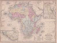
1869176603Philadelphia.: E. H. Butler. circa1869. Lithographed map with original hand-colour 21.2 x 27.6 cm two inset maps of Liberia and Sierra Leone; and Egypt showing the Suez Canal text and engravings for an unrelated entry on the verso; margins dusty top edge worn with small edge tears one affecting the border and marginal chip but in good condition. Detailed map of Africa before the escalation of colonial acquisition in the 1880s. . (E. H. Butler). unknown
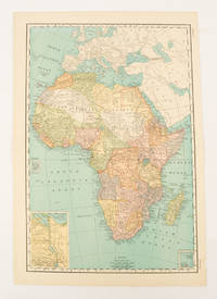
1894177068Chicago.: Geo. F. Cram. 1894. Chromolithographed maps 54.3 x 34.1 cm sheet central fold a few small edge tears and marginal age toning but in very good condition. Detailed maps prepared for George F. Cram's 1894 "Standard American Atlas": one of the first American firms to publish a world atlas. Maps of Oceania and South Africa printed on the verso. . Geo. F. Cram. unknown
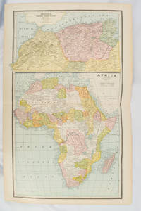
1877177229New York.: Ivison Blakeman Taylor & Co. circa1877. Printed colour map 27.5 x 21.7 cm large inset of Northern Africa and a smaller of Southern Africa two small edge tears lower corner neatly strengthened the sheet toned but the map in good condition unrelated text printed on the verso. Map of Africa as a whole before the Imperial race for colonies in the 1880s with interesting insets of Northern and Southern Africa. . Ivison, Blakeman, Taylor & Co. unknown
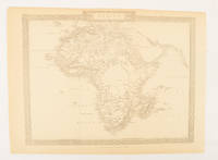
1880174956London.: The London Printing and Publishing Company. Circa1880s. Printed map 24 x 32.1 cm decorative border two original vertical folds paper toned mainly at the edges inner margin of the sheet ragged but in good order. A late edition of the map used for the well-known Tallis map this without the characteristic vignettes and on thinner paper. . The London Printing and Publishing Company. unknown
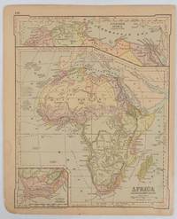
1899174902New York.: Rand McNally & Co. 1899. Printed colour map 36.3 x 24.3 cm inset map of the Suez Canal and two smaller insets of the Cardagos Crayos Islands Mascarene Islands and Cape Verde Islands central fold and on the verso a printed panel listing the countries in Africa with their territorial governance area and population lower corner creased at the outer margin but in very good condition. An interesting late nineteenth-century map noting colonial governance. . Rand, McNally & Co. unknown