[AFRICA - MAP].Biblio.com
190 résultats
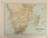
1877177228Edinburgh & London.: W. & A. K. Johnston. circa1877. Printed colour map 25 x 32.5 cm edge tears one affecting the lower border only two small chips from the upper margin corner repaired the map in very good condition. Map of North America with a small inset of the British Isles on the verso. Map of Southern Africa before the Scramble for Africa in the late 19th Century. . W. & A. K. Johnston. unknown
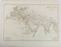
1820177230Paris. circa1820. Engraved map with original outline hand-colour 21.1 x 31.5cm original folds a few spots and a little creased but in very good condition. Latin map of the Ancient world encompassing Europe India Arabia the Middle East and North Africa by the French cartographer Jean Baptiste Poirson 1761-1831 finely engraved. . unknown
1875174830New York.: Harper & Brothers. 1875. Map printed in colour polar projection 21 x 27.1 cm marginal spotting and toning small edge tears to the inner margin but in god condition. Prepared for "Harper's School Geography" first published by Harper & Brothers in 1875. The map shows physical features mountains steppes plains rivers and deserts etc. together with sources of primary production: whale fisheries furs coffe tea minerals etc.The verso of the map with references and attractive line engravings part of the entry for Netherlands and Belgium. . Harper & Brothers. unknown
1900174904circa1900. Map printed in colour text in English provinces shaded in colour 28.3 x 23.2 cm central fold paper toned a small edge tear confined to the outer margin but in good condition. . unknown
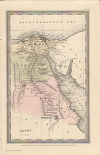
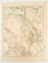
1833174939London.: Published for the Proprietors by Mr. Bull. 1833. Engraved map 14.1 x 8.8 cm original hand colour in very good condition. Fine miniature map with appealing hand colour denoting Lower Central and Upper Egypt. . Published for the Proprietors by Mr. Bull. unknown
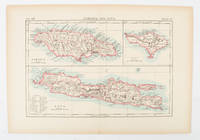
1900174875London and New York.: Encyclopedia Britannica. circa1900. Map in three insets after W & AK Johnston engravers with printed outline colour 18.9 x 28.9 cm central fold paper age-toned but in very good condition. Interesting map which first appeared in the ninth edition of Encyclopedia Britannica. . [Encyclopedia Britannica] unknown
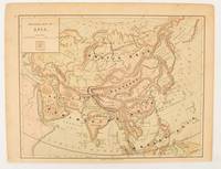
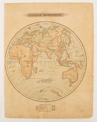
1875175128Harper & Brothers. 1875. Spherical map printed in colour 21.3 x 21.2 cm with shaded key to elevation and ocean currents unrelated text on the verso paper toned and margins soiled bottom edge ragged small sealed to to the inner margin but in sound condition. Map showing the five continents of Asia Africa Antarctica Europe and Australia. Published by Harper & Brothers for inclusion in their "School Geography". Plateau of Tibet very prominently marked. Gobi Desert and Plateau of Mongolia also marked India described as Hindostan Indo-China includes Thailand. . Harper & Brothers. unknown
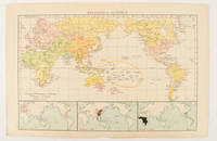
1895175135London.: Times Atlas of the World. 1895. Map printed in colour 23.2 x 35.9 cm. two edges gilt with three inset maps key to religions outlined in colour bottom margin chipped edges browned a few silverfish abrasions affecting the verso but in good condition. . (Times Atlas of the World) unknown
1874174897London.: Virtue & Co. circa1874. Printed colour map 18.4 x 24.1 cm edge wear marginal spotting and on the verso but the map in very good condition. Unusual map showing time differences east and west of Greenwich before the atomic clock and well before satellites! The explanatory text notes aso that: "The space comprehended between the meridiens of 120 & 160 E. is repeated in order to show the relative position of England to Australia both eastward and westward." . Virtue & Co. unknown
1830009582Paris - 21 Quai Voltaire: Rosselin 1830. Map. Fine. Map. A fine map hand-coloured in outline folding into original marbled paper boards with title label to the front board. Boards rubbed conrners worn. The map measures 74 x 55cm and is in very good condition with the paper bright. A very good to fine copy of this rare map. Rosselin hardcover
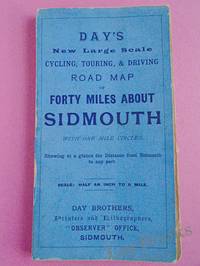
1900033970Sidmouth: Day Brothers 1900. Map. Very Good. Unframed. New Edition. Undated but circa 1900 Engraved map main roads coloured orange 445 x 575 mm folding down to 150 x 85 mm with printed blue covers published by Day Brothers "Printers Stationers & Booksellers Observer Office Sidmouth". Generally in very good condition with light general wear and some rubbing to edges of covers. An attractive map. Scarce. Day Brothers unknown
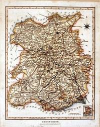
182761872London.: J. Wilkes. 1827. Attractive hand coloured map of Shropshire 27.5 x 21.5 cm. very occasional light foxing on reverse but not visible on the image itself. A most attractive map. . [J. Wilkes.] unknown
186496045Mine Hill and Schuylkill Haven Rail Road Company 1864. Pamphlet. Used - Very Good. 13-31 pages each. Large folding map. 9 x 6" printed wrappers. Lacking 1 lower wrap 1 creased few edge chips soiling tear else VG. Mine Hill and Schuylkill Haven Rail Road Company unknown
184719019Auxerre Perriquet 1847 In-8 146 + 296 pp + 2planches , rousseurs d'usage ; traces de frottements au dos Il manque probablement une grande planche dépliante d'après Belleforest
1820705531820. unknown
1827ZB311596Washington: gales & Seaton 1827. 7 pp issued as 19th Congress 2d Session S 14; extraction roughness and sewing stabs at spine previous owner's name on title age staining good only in self wrappers; one and three quarter million dollars were expended since 1811 a considerable sum at the time. - If you are reading this this item is actually physically in our stock and ready for shipment once ordered. We are not bookjackers. Buyer is responsible for any additional duties taxes or fees required by recipient's country. Washington: gales & Seaton, unknown
18860011204Chicago: Percival Lowell General Passenger Agent C. B. & Q. R.R. 1886. Revised and Enlarged Edition. Sewn wrappers. Good. 16mo 88 pages dedication page chipped lacks 99% of its flexible covers <br/><br/>The prior 1885 edition had only 80 pages. This has its frontispiece and numerous small maps other illustratios throughout. This includes travel to Mexico. Percival Lowell, General Passenger Agent, C. B. & Q. R.R. unknown
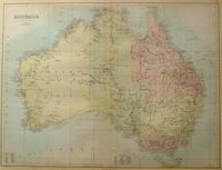
188456997Edinburgh.: A & C Black. 1884. Printed colour map of Australia some light foxing few minor tears browned edges still a clear and bright image. Map measures approximately 42 x 55cm. . A & C Black unknown
184719060Auxerre Perriquet 1847 In-8 146 + 296 pp + 3 planches , DONT une grande planche dépliante d'après Belle-forest en 1575? Cette planche est complète mais séparée à la pliure supérieure, morceau volant dos légèrement passé
187912414Lyon, Imprimerie typographique H. Albert, 1879 ; petit in-8 carré, broché ; 242, (6) pp., couverture gris-bleu imprimée.
1832ZB348420Washington: 1832. 5 pp issued as 22d Congress 1st Session HD 52; untrimmed in self wrappers but tattered at margins and with an overall wrinkle no text lost but good only; repairs will cost a little over $230000 shortly thereafter the decision was made that the individual states should be responsible for maintenance in their own sections. - If you are reading this this item is actually physically in our stock and ready for shipment once ordered. We are not bookjackers. Buyer is responsible for any additional duties taxes or fees required by recipient's country. Washington: unknown
1895175108London.: Times Atlas of the World. 1895. Double-page folding map printed in colour 46.5 x 36.5 cm. edges gilt central fold with an inset map of Somaliland Somalia and the island of Sokotra key to European possessions outlined in colour small edge fold tears affecting the margin only and two other small edge tears slight toning at the edgaes but in very good condition. Attractive and detailed map prepared for the first edition of "The Times Atlas of the World". . (Times Atlas of the World). unknown
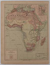
1877176015New York.: Harper & Brothers. circa1877. Chromolithographed map with outlne handcolour 27.1 x 21 cm major towns marked with a red cross relief by hachures ocean currents marked two inset maps of the Suez canal and Mascarene Island two very small marginal edge tears not affecting the map slight toning unrelated text on the verso prepared for "Harper's School Geography" in very good condition Interesting map of Africa before the escalation of the European race for colonial possessions from 1880. The map shows: the European possessions of the Cape Colony Transvaal Republic Orange River Republic and Natal; regions of the continent as fertile belts and desert belts; and indicates agricultural and other production such as palm oil ivory skins and cattle. Major cities are shown with important trade centers highlighted with a red cross. Prepared for US students in "Harper's School Geography" longitude is shown from the Greenwich prime meridian at the head of the map and from the Washington prime meridian at the foot. A small outline map of Ohio is included for relative scale. . Harper & Brothers. unknown
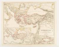
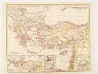
1874174914Gotha: Justus Perthes. 1874. Map with original colour and outline hand-colour 32.2 x 40 cm three inset maps text in German central fold slight marginal toning in very good condition. A most handsome map detailing the Eastern Roman Empire from the immigration of Hungarians in Ponnonia around 895 to the subjugation of the Bulgarian Empire by Emperor Basilius in 1019. The inset maps depict Divisions of the Empire Palestine and the Themata around Propontis present day Sea of Marmara issued for the "Hand-Atlas für die Geschichte des Mittelatters und die Neueren Zeit". . Justus Perthes unknown
1876174911Gotha: Justus Perthes. 1876. Map with original colour and outline hand-colour 32.2 x 40 cm text in German four inset maps central fold slight marginal toning and spotting on the verso but in very good condition. A most handsome and highly detailed map detailing the Eastern provinces of the Byzantine/Roman Empire before the Fourth Crusade. The inset maps depict Constantinople Divisions of the Empire and Antioch issued for the "Hand-Atlas für die Geschichte des Mittelatters und die Neueren Zeit" . Justus Perthes unknown