190 résultats
1823ST20595London: Longman Hurst Rees Orme and Brown 1823. Seventh Edition. 237 x 145. 9 3/8 x 5 3/4". 3 p.l. vii 1 viii 1 6-236 pp. <br/> Publisher's blue paper boards and brown paper backstrip original printed paper label EDGES UNTRIMMED AND MOSTLY UNOPENED. A Large Paper Copy. Just the faintest evidence of foxing at very beginning and very end corners with slight wear as always superficial chafing to covers but AN EXCEPTIONALLY FINE COPY the binding remarkably clean and with no significant signs of use and the wide-margined text unusually fresh and nearly as white as snow.<br/> <br/> In its original boards untrimmed and partly unopened this is a wonderful contemporary copy of an important later edition of the magnum opus of a man whose name came to be synonymous with road improvement. DNB tells us that Scottish-born John Loudon McAdam 1756-1836 was "the first systematic builder and administrator of roads in Britain since Roman times" and his impact was so great that his name lives on to the present day in connection with paved surfaces. The use of "macadam" or "macadamized" to mean a good road surface began in the 1820s and continued through the invention of the automobile when dusty roads began to be improved with tar. At first "tar" was combined with "macadam" producing the term "tarmacadam" when referring to these improved roads; eventually this became shortened to "tarmac" which still is broadly understood to refer to road surfaces and more specifically to airport runways. Our author first published "Remarks on the Present System of Road Making" in 1816 to deliver his suggestions for an improved paving method following his extensive survey of the roads of Britain. His system--in which roads were built with a cambered surface for drainage using layers of consistent sizes of stones and gravel--soon caught on both within Britain and abroad. The present seventh edition features a variety of new material much of which deals with McAdam's efforts to encourage legislation for improving roads; this includes a new preface and advertisement as well as the "Minutes of Evidence" given by witnesses regarding turnpike improvement from March to May 1819 and the report of the Select Committee of the House of Commons on McAdam's system from June 1823. As evidenced by its appearance in multiple printings McAdam's "Remarks" was a widely used book but our remarkably well-preserved copy in its publisher's boards--obviously and decidedly--was not. Longman, Hurst, Rees, Orme, and Brown unknown
1844GD012817okBC1S5Manchester: Wetmore & Wallace 1844. Manchester: Wetmore & Wallace Rare Americana 1844 First Printing. 8vo. 16 pages with folding map at rear of wrappers. The folding map titled :Plan and Profile of the Route Surveyed for the Northern Railroad from Concord to Lebanon N.H." measuring approxinately 28" long and 9" wide. The map is in extremely nice condition. The spine shows some wear but remains a very nice copy. A signature of S.Chase" appears on the front wrapper. There is an institional rubber stamp on the margin of page 3. Vermont Historical Society Montpelier Vermont. This report printed by Wetmore & Wallace Printers in Manchester New Hampshire presents the findings of an engineer's survey for the Northern Railroad route. It covers the planned railroad connections between Concord Franklin and complete with Lebanon along the Connecticut River. Published in 1844 this document provides historical insight into the development of New Hampshire early railroad infrastructure and the engineering challenges faced in the region at that time. Scarce copy last auction records 1930. First Printing. Paperback. Good/No Jacket. 8vo - over 7¾" - 9¾" tall. Manchester: Wetmore & Wallace
1846WRCAM17477New Braunfels 1846. Printed indenture 10 1/2 x 8 1/2 inches executed in ink. Some old folds light soiling. "55" written in red pencil in top blank margin. Very good. Printed indenture executed in ink and signed in full by John O. Meusebach as Trustee of the German Emigration and Rail-Road Company drawing on the banking firm of H. Flersheim in Frankfurt for the sum of $3000 to be deposited to the account of the Company dated December 12. Meusebach a highly educated and civilized man came to Texas from Germany in 1845 to succeed Prince Carl of Solms-Braunfels as commissioner-general of the Verein zum Shutze Deutscher Einwanderer in Texas in the course of which he assumed Texas citizenship oversaw the affairs of the colonists and accomplished the 1847 treaty with the Comanche chiefs which made colonization possible. This document coming from the period of his service to the Verein no doubt represents a draft for funds to further the establishment of the colony the cities of New Braunfels and Fredericksburg and the attempted settlement of the financial horror show which Prince Carl left behind. A superb piece signed by one of the major figures of early Texas colonization. unknown books
1824PHO-2191Paris, Everat, 1824, in-4 (260x210mm), 2ff-LIV-568pp-1ff , avec en fin d’ouvrage la liste des membres de la Société de Géographie, relié demi toile, dos lisse avec étiquette de titre, éditeur et tomaison, frottements aux plats et étiquette usée, vieille mouillure claire en coin, piqures.
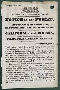
1850List2416Great Britain 1850. Broadside measuring 9 ⅞ x 15 ⅜ inches. Some chipping and wear to edge ink number written in corner two small section of loss due to improper mounting very good overall. Coat of arms of the United Kingdom above printed text. Very Good. A scarce broadside relating to British postal rates across the Panama Route through the Chagres River which supplied mail to California and Oregon beginning in 1848 before eventually being replaced by the Overland route in 1860. The service was characterized by long delay times as steamships on either side of the isthmus were often not coordinated causing major delays in the delivery. Several different steamship companies operated privately some carrying express mail. The letters were transported by canoe or pack animal across the isthmus. Postmaster General Cave Johnson began establishing post offices in California in 1848. Johnson also oversaw the transition to the prepaid delivery system. The broadside here of which we find no other records does state that postage must be prepaid and that the route can be accessed by writing “via New York†on the letters. A scarce postal history item relating to the expansion of mail services to California. We find no other records of this institutionally or in the trade. unknown
18462090502128300687Not Available 1846. Soft Cover. Fine. The book is in fine condition. Not Available paperback
1840018232London: Printed and Published By J. Barfield 1840. Book. Very Good. Hardcover. Fourth Edition. Folio 30 x 46cm. "Revised Collated and Considerably Enlarged by John Satchell Esq." Seventy-four double-page engraved genealogical tables and geographical maps all with original hand colouring contemporary . half black morocco gilt with green cloth boards. Binding good with some general wear and rubbing leather chipped with loss to the base of the spine joints rubbed but still strong corners worn. All edges gilt./ Contents clean and tight contemporary ink stain effecting the fore-edges of the first few pages but not affecting text or maps most noticeable to the front end papers with also have a pencil inscription dated 30 November 1935. All maps and charts in very good condition. Notwitstanding wear to the binding a very good copy. Printed and Published By J. Barfield Hardcover
183523580MÉXICO: Impreso por Ignacio Cumplido 1835. Primera edición.- 4º.- Plena piel jaspeada de época lomera con filetes y florones dorados.- 2 tomos en 1 volumen.- I: 32 páginas.- II: 56 páginas.- III: 44 páginas. El Apéndice de documentos no indica lugar ni año. El primer documento lleva la fecha de México 24 de febrero de 1835 y el último es de 23 de mayo del mismo año. Procedencia: Ejemplar de Joaquín Gómez de la Cortina Marqués de Morante. Palau 111572 para la segunda edición y 74785 Impreso por Ignacio Cumplido unknown
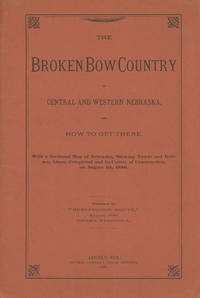
188647038Lincoln: Journal Company State Printers 1886. 1886. NEBRASKA RAILROAD. First edition. 8vo. Original orange printed wrappers 16 pp. folding map: Map of Nebraska 1886. 59 x 99 cm. 23 1/4" x 41" 12 miles to one inch. The map was the project of the Burlington Route for selling land. Very detailed and routes outlined in bright red. Broken Bow was to be the new center of life in Nebraska. The map is in fine condition some splitting at the bottom two inches of the spine due to the folded size of the map and a tiny closed tear and a few minor nicks to the rear cover fore-edge overall a near fine copy. Journal Company, State Printers, 1886. unknown
18822111902160200908Ikaho bussan 1882. Soft Cover. Fine. Volume: 1 Ikaho bussan paperback
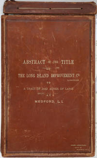
188525162Riverhead New York 1885. Hardcover. Very good condition. The original manuscript title to a very large tract of land near Brookhaven Long Island acquired by John A. Bowman from the individual proprietors and conveyed here by Bowman in its entirety to the Long Island Improvement Company Ltd. <br /> <br /> The Long Island Improvement Company was formed by Austin Corbin then president of the L. I. Rail Road and others in 1881. Corbin sought the land in order to develop expensive summer residences on Long Island; Bowman was acting as Corbin's agent in the acquisition of this valuable property. Austin Corbin 1827 – 1896 was an American railroad executive plantation owner resort operator banker and robber baron. In Iowa as a bank president he engaged in mortgage scams. Later through theft and corruption he consolidated the individual rail lines into the profitable Long Island Rail Road. He was widely despised in his day: Puck Sept 1882 printed a caricature in which Corbin appears at a Louis XIV styled party where he carouses with Jay Gould and other robber barons. <br /> <br /> The Abstract a bound sml. folio volume records that Bowman paid $5 per acre for most of the parcels in 1882 then conveyed January of 1883 the incalculably valuable entire tract to the LI Improvement Co for $1. The Abstract volume concludes with the Suffolk County embossed seal and is signed by the Clerk at Riverhead 1st June 1885. It includes the ownership history of each parcel as well as a history of the town of Brookhaven from its founding.<br /> <br /> The Abstract volume is accompanied by the original hand colored manuscript map on architectural vellum of the entire tract with silk ribbon binding showing the 25 property owner names and parcel sizes. Surveys were conducted by Justus Roe. The map is titled "Map of Property of the Long Island Improvement Company Limited at Medford LI". The scale is 300 feet to the inch. The northern boundary of the tract shows the Brewster Terry Property and Horse Block Road; the western edge defined by Tunnel and Progues Road and the Austin Roe and Daniel Gerard property; the southern boundary with Georgianna Rider property and Canaan and Medford Roads; the eastern boundary with the Robinson property and Lime Road. The Long Island RR can be seen running from east to west at approximately one third of the way through the tract at the north side. The map signed in ink at the lower right corner E. H. H. Forder.<br /> <br /> The Abstract bound in full gilt tan leather 9 x 14 3/4" attorney's name stamped in gilt at lower corner James Armstrong Attny 115 B'Way N. Y. Boards slightly rubbed; front board detached but present. Pages very bright and clean. The map 67 x 44" a few short splits at folds but very bright and clean in very good condition.<br /> <br /> A remarkable record of Long Island land speculation in the late 1880s. hardcover
18572234Genève, Impr. de Gme Fick, 1857. In-folio broché de IX-69 pages, 29 planches. Coupes légèrement déchirées sur les plats, deux petits manques au bas et haut du dos, quelques rousseurs.
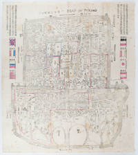
1900169765Circa1900. Large illustrated map of Beijing showing the city in the period following the invasion of the military forces of the Eight National Alliance old folds scale not given. Some scattered light foxing particularly at edges short closed tear at fold lower edge neat non acidic tape repair short section upper edge wear along folds and a couple of small unobtrusive holes with minor image loss. Blocks of text in traditional Chinese right and left upper sections stating each nation's occupied zone Japanese text title accompanies the English title along the upper section of the map. 63.7 x 56.9cm. Very good overall. A rare and significant large Japanese woodblock map of Peking Beijing issued just after the suppression of the Boxer Rebellion. Centred on the Forbidden City the map depicts Peking following the multinational suppression of the Boxer Rebellion or Yihetuan Movement of 1900. The map was issued to illustrate the areas of occupation associated with each of the powers in the Eight Nation Alliance. <br> <br>The map gives measurements of the city walls detailed names of streets and buildings and the boundaries of the inner and outer city including the forbidden city are shown with demarcation lines in pink yellow and blue. The hand coloured eight national flags of the occupation powers are featured at the right and left. <br> <br>This map is essentially a later edition of 京城内外首善全圖 a map of Beijing issued by the Qing for administrative purposes in the mid-19th century. The Japanese seized the wood blocks during the suppression of the Rebellion and subsequently pulled new impressions overprinting them additional details including flags and demarcations of areas of the city held by members of the Alliance. Versions are known in French German Japanese and as with the present example English. An attractive map of great historical interest. . unknown
1838021038London: T. McLean D.& P. Colnaghi and John F. Lewis 1838. 1838. Book. Illus. by John F. Lewis. Near Fine. Hardcover. First Edition. Folio approx. 55 x 36.5cm. Complete with all Lithographic plates as called for; tinted frontispiece tinted title-vignette further 27 tinted views on 25 leaves all by Lewis after Coke Smyth. A very clean bright copy. Finely bound in modern brown morocco to style with gilt lettering to the spine and gilt bands to the top and bottom of the spine. Contents clean and tight new light brown endpapers in keeping with the new binding two blank leaves to the front and rear all pages have been professionally cleaned and restored by a paper conservator minimal and unobtrusive water staining remains to some pages and plates mostly confined to the margins and blank areas most plates unaffected new archival paper guards to all plates no inscriptions. A fine complete copy beautifully rebound. References -. Abbey Travel II 394; Atabey 722; Blackmer 1015; Contominas 413; RIBA 1886. T. McLean, D.& P. Colnaghi and John F. Lewis [1838]. Hardcover
1835377678Mexico 1835. 1. plus integral blank. Signed in print by Estrada. Folio. Unbound. 1. plus integral blank. Signed in print by Estrada. Folio. A broadside decree issued by Migual Barragan giving city status to Pueblo de Nuestra Se ora la Reina de Los Angeles and naming it the provisional capital rather than Monterey. The Mexican congress declares: "The town of Los Angeles of Alta California is elevated to the rank of city and it will be from now on the capital of this territory." However representatives from Monterey would block moving the capital. <br /> <br /> "This decree was largely due to the efforts of Carlos Antonio Carrillo the deputy from California to the Mexican Congress and the author of the Exposicion of 1831" Streeter. Streeter's copy sold for $200 to Dawson's in 1968. Eberstadt 133-187; Streeter sale 2476; Rocq 4223 unknown