Estrada, PauBiblio.com
Turner, Reverend MrBiblio.com
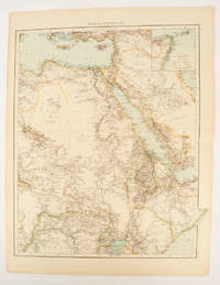
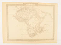
A VIEW OF THE EARTH: Being a Short But Comprehensive System of Modern Geography
1766016077London: Printed for S. Crowder 1766. Book. Very Good. Hardcover. The Second Edition. Folio 21 x 32cm. The second edition with additions and improvements; pp. iv 45 iii publisher's adverts; engraved frontispiece map of the world five further engraved plates of maps and one engraved plate of globes ten engraved figures and diagrams within the text. Contemporary half textured calf binding with marbled paper boards expertly restored with a new spine in matching style re-corned. contents clean and tight a few small marks/reading wear; frontispiece plate with a couple of short edge-tears expertly and inconspicuously repaired a few corners re-tipped. A very good well-presented copy. Scarce. Printed for S. Crowder Hardcover

Loe Books · Royaume-Uni495,00 £GB≈ 565,19 €