Speed, HaroldBiblio.com
1 203 résultats
9353896452.Gpaperback. Good. Access codes and supplements are not guaranteed with used items. May be an ex-library book. paperback
1025970144.Ghardcover. Good. Access codes and supplements are not guaranteed with used items. May be an ex-library book. hardcover
aly1568London: Chapman and Hall Ltd. 1926. Second Impression. 8vo. pp. 8vo. pp. xii 275. 58 plates. Cloth ex lib. with rubber stamps edges rubbed with some fraying front joint loose London: Chapman and Hall Ltd., 1926 hardcover
1804508098.Gpaperback. Good. Access codes and supplements are not guaranteed with used items. May be an ex-library book. paperback
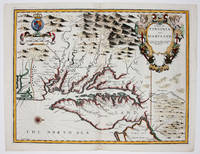
16769394London 1676. No Binding. Near Fine. 14 3/4 x 19 ¼ inches. Fine hand color; wear to bottom of centerfold else fine condition. A very attractive near-mint example. Speed's handsomely engraved work is one of the earliest English maps of the area and one of the first to demarcate the borders of colonial Virginia and Maryland. Just three years before the publication of Speed's map Augustine Herrman had conducted the first thorough surveys of Maryland at the behest of Lord Baltimore. Speed's was one of the first maps to adopt this groundbreaking cartography. However in general outline Speed still followed the prototype of Captain John Smith who conducted the first European survey of Chesapeake Bay. Speed's map "is the last major derivative of the Smith map and it is unique as an example of the transition from one basic prototype map to another. The delineation of the land area follows Smith while the toponymic prototype was the Herrman map of 1673." Verner in Tooley Mapping of America p.170 A particularly important feature derived from Herrman by Speed is the boundary line indicated by a double row of trees between Virginia and Maryland on the Eastern Shore. English text on the verso contains extensive descriptions of Virginia and Maryland. unknown
0243446640.Gpaperback. Good. Access codes and supplements are not guaranteed with used items. May be an ex-library book. paperback
1164245686.Ghardcover. Good. Access codes and supplements are not guaranteed with used items. May be an ex-library book. hardcover
134205198X.Ghardcover. Good. Access codes and supplements are not guaranteed with used items. May be an ex-library book. hardcover
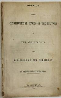
186532612Washington 1865. 16pp disbound. Front wrapper only light waterstain running through outer edges of text. Good.<br /> <br /> Speed was a Kentuckian appointed as Lincoln's Attorney General in 1864. Though a Border State moderate he quickly became an all-out Union man with the outbreak of war. Here he opines that trial of the alleged presidential assassins should occur by military commission rather than civil courts: the law of war as part of the law of nations has implicitly been adopted in the Constitution. <br /> "When lawless wretches become so impudent and powerful as not to be controlled and governed by the ordinary tribunals of a country armies are called out and the laws of war invoked." The laws of war do not require different treatment of "secret active enemies" and "open active enemies" who would be tried by military tribunal. Under these circumstances the alleged assassins may be tried by military court without a jury. <br /> FIRST EDITION. Monaghan 739. II Harv. Law Cat. 634. 165 Eberstadt 471. Not in LCP. unknown
1340195844.Ghardcover. Good. Access codes and supplements are not guaranteed with used items. May be an ex-library book. hardcover
0877971447New. New. Satisfaction Guaranteed or your money back. unknown
0877971447.Ghardcover. Good. Access codes and supplements are not guaranteed with used items. May be an ex-library book. hardcover
200045232Waddesdon: Map Collector Publications 2000. First edition. Large oblong 8vo. 172 pp. Publisher's green cloth gilt lettered to the spine dust jacket. Colour reproductions of the original plans throughout. Sunning to the jacket at slightly unusual angles else very good. Waddesdon: Map Collector Publications unknown
0906430232.Gpaperback. Good. Access codes and supplements are not guaranteed with used items. May be an ex-library book. paperback
1169038611.Ghardcover. Good. Access codes and supplements are not guaranteed with used items. May be an ex-library book. hardcover
1340912384.Ghardcover. Good. Access codes and supplements are not guaranteed with used items. May be an ex-library book. hardcover
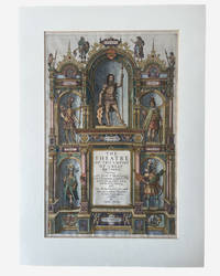
1627003914George Humble. SPEED John. A hand coloured title page from 'The Theatre of the Empire of Great Britaine'. London: George Humble 1627. Hand-coloured engraved allegorical title page from Speed's celebrated atlas of Great Britain. Image size approximately 390 x 250 mm. Mounted for display. Overall an excellent near fine example mounted verso with archival tape. This title page is from the 1627 edition on laid paper with attractive early hand-colouring depicting allegorical and historical figures representing the successive peoples of Britain including the Britons Romans Saxons Danes and Normans surrounding the architectural title framework. Imprint at foot: "Are to be sold by George Humble at the White Horse in Popes-head Alley." The engraved title page formed part of John Speed's monumental The Theatre of the Empire of Great Britaine first issued in 1611 and regarded as the first major atlas of the British Isles produced by an English cartographer. . Very Good. Soft cover. 1st Edition. 1st Printing. 1627. George Humble paperback
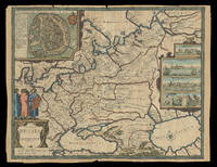
167621930<p>London: Sold by Tho: Basset in Fleet Street and Richard Chiswell in St. Pauls Church yard 1676. 405 by 515mm. 16 by 20.25 inches. Speed's map of Russia Double-page engraved map with hand-colour. A map of Russia one of the nine new maps added to the 1676 edition of Speed's 'Prospect' the first atlas compiled and published by an Englishman. Unusually this map is not in the carte-à-figure style that characterizes the 'Prospect'. Instead set in the top left-hand corner of the map is a detailed plan of Moscow with points of particular interest such as 'The Emperours Palace' and 'The Horse market' labelled. On the right-hand side is an elaborate cartouche containing views including 'Archangel' Arkhangelsk and 'A Hott House'. Accompanying text in English 'The Description of Russia' is printed on the reverse. John Speed 1552-1629 was the outstanding cartographer of his age. By trade a merchant tailor but by proclivity a historian it was the patronage of Sir Fulke Greville poet and statesman that allowed him to pursue this interest in earnest. His 'Theatre of Great Britain' first published in 1611 or 1612 was the first large-scale printed atlas of the British Isles. The 'Prospect of the Most Famous Parts of the World' from which the present work is drawn appeared in 1627 bound with the 'Theatre' and is the first world atlas compiled by an Englishman to be published in England. Engraved in Amsterdam many of the maps are anglicized versions of works by Dutch makers in distinctive carte-à-figure style featuring borders with figures in local costume and city views. This map is from the 1676 edition of the 'Prospect' published by Thomas Bassett and Richard Chiswell. While not as rare as the earlier publications this edition is perhaps the most important given that it is the first to include the nine new maps: among them Virginia and Maryland Barbados and the present example Russia. It is also the last time that the 'Prospect' was printed as an atlas. Shirley Atlases T.SPE-2f.</p> Sold by Tho: Basset in Fleet Street and Richard Chiswell in St. Pauls Church yard,
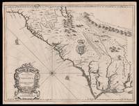
167615098London: Thomas Bassett and Richard Chiswell 1676. 380 by 505mm. 15 by 20 inches. Sheet size 408 by 530mm 19 x 21 inches. Engraved map with text on verso. A fine and attractive map of the Carolina colony. Publishers Thomas Bassett and Richard Chiswell republished English cartographer John Speed's 1552-1629 popular 1611 atlas "The Theatre of the Empire of Great Britain" in 1676. As a supplement they included new section "A Prospect of the most Famous parts of the World" which contained maps engraved by Francis Lamb of the English colonies of New England and New York Virginia and Maryland Carolina and Florida and Jamaica and Barbados. This map depicts the Carolina colony in 1676 drawing from the Lord Proprietor's Map by royal geographer John Ogilby and the explorations of John Lederer fl. 1670-1675. The map orients the West to the top and depicts the coastline from Cape Charles at the mouth of the Chesapeake Bay to the north and St Augustine Florida to the south. Looking inland the Appalachian Mountains marked as "Apalathean Mountains" cut across the top right section of the map. The present map features a cartouche where the Ogilby publication had an inset map of the Ashley and Cooper Rivers. This map is one of the first to name Charleston "Charles Town" on the banks of the Ashley River. The map correctly identifies the town on the south bank of the Ashley River whereas Speed's smaller format map of Carolina incorrectly places the town on the north banks of the river. King Charles II granted eight Lord Proprietors land in North America that extended between 31 and 36 degrees latitude later extended to 29 degrees. Lederer was a German explorer who travelled West from the East coast of Virginia in hopes of finding the Pacific and the "Sea of China" with its associated riches. He never did reach the Pacific - unsurprisingly - but his personal records of his travels influenced contemporary maps. His description of the "Arenosa Desert" reflects Lederer's memory of crossing the Carolina pine barrens in the blistering summer heat. The "Great Lake" is likely the Catawba flooded which he mistook as permanent. In total Lederer traipsed across Virginia and the Eastern coast three times making it as far as the Blue Ridge mountains. Lederer's discoveries are recorded in Sir William Talbot's translation of the explorer's account from Latin to English and published in London in 1672 as "The Discoveries of John Lederer in three several Marches from Virginia To the West of Carolina." On the verso the text describes Lederer's journeys and discoveries. Burden 457 Cumming 77 Thomas Bassett and Richard Chiswell, unknown
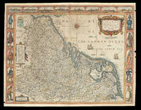
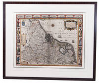
167621920<p>London: Are to be sold by Thomas Bassett in Fleet Street and Richard Chiswell in St. Pauls Churchyard 1676. 420 by 540mm. 16.5 by 21.25 inches. Speed's map of 'Low Germanie' Double-page engraved map with hand-colour. A map of 'Low Germanie' the modern-day Netherlands from the 1676 edition of the first atlas compiled and published by an Englishman Speed's 'Prospect'. A decorative border along the top of the map depicts views of major cities among them Amsterdam and Utrecht. Along each side of the map are illustrated figures in regional costume. Accompanying text in English 'The Description of Belgia' is printed on the reverse. John Speed 1552-1629 was the outstanding cartographer of his age. By trade a merchant tailor but by proclivity a historian it was the patronage of Sir Fulke Greville poet and statesman that allowed him to pursue this interest in earnest. His 'Theatre of Great Britain' first published in 1611 or 1612 was the first large-scale printed atlas of the British Isles. The 'Prospect of the Most Famous Parts of the World' from which the present work is drawn appeared in 1627 bound with the 'Theatre' and is the first world atlas compiled by an Englishman to be published in England. Engraved in Amsterdam many of the maps are anglicized versions of works by Dutch makers in distinctive carte-à-figure style featuring borders with figures in local costume and city views. This map is from the 1676 edition of the 'Prospect' published by Thomas Bassett and Richard Chiswell. While not as rare as the earlier publications this edition is perhaps the most important given that it is the first to include the nine new maps: among them Virginia and Maryland Barbados and Russia. It is also the last time that the 'Prospect' was printed as an atlas. Shirley Atlases T.SPE-2f.</p> Are to be sold by Thomas Bassett in Fleet Street and Richard Chiswell in St. Pauls Churchyard,
1626ACH8NIO8K9DULondon: George Humble 1626. Framed. 41 x 53 cm. Engraved map with hand coloured borders probably by Pieter van den Keere 1571-after 1646. Incorporating a fine compass-rose with 32 rhumb lines and names of the wind-directions a coat of arms of France a title-cartouche a legend "A catalogue of the cities et ! villages in everie Province" and an indication of scale ca. 1:1.120.000. The map is topped by 8 hand coloured miniature profiles of major cities and bordered by hand coloured figures in local costume at the left 5 male figures and right 5 female figures. Very fine and attractive map in its first edition as published in John Speed's A Prospect of the most famous Parts of the World London 1627. The very successful map was republished in 1654 in two different states and 1674. Its decorative border incorporates profiles of Amsterdam Antwerp Ghent Middelburg Groningen Zutphen Utrecht and Atrecht and figures depicting "a Gentle woman" "a Brabanders wiffe!" "a Hollanders wiffe !" "a Fishers wiffe!" "a Contreywoman!" and their male counterparts.Slightly creased with restored tears along the head and foot of the central fold. Otherwise a very good copy.l Van der Heijden 88 first state of 4. George Humble, unknown
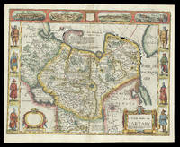
167621929<p>London: and are to be sold by Tho: Bassett in Fleet Street & Richard Chiswell in St. Pauls Churchyard 1676. 395 by 510mm. 15.5 by 20 inches. Speed's map of 'Tartary' Double-page engraved map with hand-colour. A map of Tartary encompassing parts of modern-day Siberia and Central Asia from the 1676 edition of the first atlas compiled and published by an Englishman Speed's 'Prospect'. The decorative border that runs along the top of the map depicts views of major cities as well as the house built on 'Nova Zemla' Novaya Zemlya by the explorer Willem Barentsz and his crew stranded there in 1596 here presented fending off a polar bear. Along each side are illustrated figures in regional costume. Accompanying text in English 'The Description of the Kingdom of Tartary' is printed on the reverse. John Speed 1552-1629 was the outstanding cartographer of his age. By trade a merchant tailor but by proclivity a historian it was the patronage of Sir Fulke Greville poet and statesman that allowed him to pursue this interest in earnest. His 'Theatre of Great Britain' first published in 1611 or 1612 was the first large-scale printed atlas of the British Isles. The 'Prospect of the Most Famous Parts of the World' from which the present work is drawn appeared in 1627 bound with the 'Theatre' and is the first world atlas compiled by an Englishman to be published in England. Engraved in Amsterdam many of the maps are anglicized versions of works by Dutch makers in distinctive carte-à-figure style featuring borders with figures in local costume and city views. This map is from the 1676 edition of the 'Prospect' published by Thomas Bassett and Richard Chiswell. While not as rare as the earlier publications this edition is perhaps the most important given that it is the first to include the nine new maps: among them Virginia and Maryland Barbados and Russia. It is also the last time that the 'Prospect' was printed as an atlas. Shirley Atlases T.SPE-2f.</p> and are to be sold by Tho: Bassett in Fleet Street & Richard Chiswell in St. Pauls Churchyard,
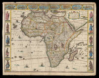
162621913<p>London: published at the charges of G. Humble 1626 but 1627-1632. 390 by 500mm. 15.25 by 19.75 inches. The first English map of Africa Double-page engraved map with hand-colour. The first English map of Africa from the first atlas compiled and published by an Englishman Speed's 'Prospect'. The map was engraved by Abraham Goos for Speed's 'Prospect of the Most Famous Parts of the World'. Along the top border are eight inset views of cities mainly in North Africa for example Alexandria Tangier and Tunis; along the side margins are inset engravings of people from different regions. The map is dense with place names rivers mountains and lakes many fictitious. While ships and sea-monsters populate the sea inland are depicted animals including zebras elephants lions and monkeys. The source of the Nile is given to the Lakes Zaire and Zaflan as according to Ptolemy. Accompanying text in English 'The Description of Africa' is printed on the reverse. John Speed 1552-1629 was the outstanding cartographer of his age. By trade a merchant tailor but by proclivity a historian it was the patronage of Sir Fulke Greville poet and statesman that allowed him to pursue this interest in earnest. His 'Theatre of Great Britain' first published in 1611 or 1612 was the first large-scale printed atlas of the British Isles. The 'Prospect of the Most Famous Parts of the World' from which the present work is drawn appeared in 1627 bound with the 'Theatre' and is the first world atlas compiled by an Englishman to be published in England. Engraved in Amsterdam many of the maps are anglicized versions of works by Dutch makers in distinctive carte-à-figure style featuring borders with figures in local costume and city views. Norwich 30; Shirley Atlases T.SPE-2a.</p> published at the charges of G. Humble,
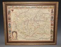
97473Are to be sold by Ric. Chiswell on St. Pauls Church yard and by The: Bassett in Fleetstreet. 1676. Lg.map engr.surface ca 55 cm x 42 cm. Frame 61.5cm x 50cm Nicely hand-coloured. An attractive and decorative map Featured "carte a figure" map adorned with side panels depicting costumed figures and further enhanced with a row of city views along the top. Prague is at the centre. The Danube River flows from west to east along the bottom of the map. An inset at right explains the symbols used. Very good. Framed in double glazed Mount. English text on verso. From: A Prospect of the Most Famous Parts of the World London Th. Bassett & R. Chiswell 1676. Are to be sold by Ric. Chiswell on St. Pauls Church yard and by The: Bassett in Fleetstreet. 1676 unknown
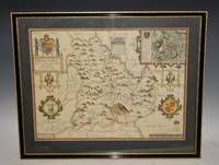
87950Bassett & Chiswell 1676. Lg. map engr.surface ca 51 cm x 37 cm. English text on verso. A nice example of this decorative County map by John Speed. Includes inset of Breknoke with the coat of arms for James Butler Earle of Breknoke and three other coasts of arms plus and early battle scene. FRAMED in double Glazed Hogarth Frame. Strong impression with the detail in the engraving clear and black. Overall in very good condition. Imprint on left- hand corner giving publishers: “Performed by John Speede. And are to be solde by Thomas Bassett in Fleetstreet and Richard Chiswell in St Pauls Churchyard”. The maps by J.Speed are "the best known and most popular of all English county maps" Tooley. Despite competition from maps of the English counties by Blaeu and Jansson Speed’ maps were “bestsellers”. A beautifully coloured map of the historic county of Brecknockshire with an inset map of the city of Brecon. Bassett & Chiswell, 1676 unknown