GONZALEZ-ALLER HIERRO, Jose IgnacioBiblio.com
2 067 résultats
200447348Madrid: Fundación Iberdrola D.L. 2004.- 282 p. 3 h.: Profusión de ilustraciones y 42 láminas por error se indican 43 a todo color; 4º mayor apaisado 307 x 406 cm; Encuadernado en Plena Tela Ed. ilustrada. Ejemplar en excelente estado de conservación. MARINA PIRATAS CORSARIOS BUCANEROS Libro en español Fundación Iberdrola hardcover
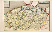
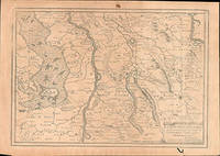
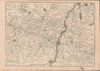
170566131Paris. c.1705. A charming map of Spanish and Dutch Flanders in the early eighteenth century. A number of the larger cities and towns are highlighted together with local physical features in the form of rivers canals woodlands and marshland. Published in de Fer's 'Atlas Curieux ou Le Monde'. Size: 275 x 400 mm. Copperplate engraving with later hand colour. Fine condition. unknown
6207231228.Gpaperback. Good. Access codes and supplements are not guaranteed with used items. May be an ex-library book. paperback
6207231252.Gpaperback. Good. Access codes and supplements are not guaranteed with used items. May be an ex-library book. paperback
9500519445.Gpaperback. Good. Access codes and supplements are not guaranteed with used items. May be an ex-library book. paperback
1931239968Paris : Compagnie des chemins de fer de l'Est 1931. First Edition. Softcover. Near fine copy in the original stiff-card wrappers; edges very slightly dust-dulled and toned. Remains particularly and surprisingly well-preserved; tight bright clean and especially sharp-cornered. Physical description; 52 p. : ill. maps plans ; 27 cm. Notes; French text. Subjects; Railroad stations — France — Paris. Gare de l'Est Paris France. Architecture. France. Compagnie des chemins de fer de l'Est. Stations. Paris. Genre; Illustrated. Paris : Compagnie des chemins de fer de l'Est paperback
2070325830.Gmass_market. Good. Access codes and supplements are not guaranteed with used items. May be an ex-library book. unknown
51-6448Paris: chez l'auteur dans l'Isle du Palais sur le quay de l'orloge a la Sphére Royale avec privilége du Roy 1705-1717. Engraved map. One fold. Worm hole in lower margin 27.3 x 38 cm. Contemporary laid paper uniformly time aged.Published in "L'atlas curieux ou Le monde reÌpreseÌnteÌ dans des cartes geÌneÌrales et particulieres du ciel et de la terre : diviseÌ tant en ses quatre principales parties que par eÌtats et provinces et orneÌ par des plans et descriptions des villes capitales et principales et des plus superbes edifices qui les embelissent comme sont les eglises les palais les maisons de plaisance les iardins les fontaines &c. ". OCLC Number / Unique Identifier:79022119.LThe Atlas Curieux is geographic encyclopedia of images and maps of France with detailed views of the grand waterworks at Marly views of the great palaces and chateaux views and plans of the Paris Observatory and samples of military architecture. Issued in six annual parts from 1700-1705 the maps are based on the new observations of the Académie des Sciences and drawn up with the assistance of Philipe de La Hire.ibrary of Congress:The French cartographer and engraver Nicolas de Fer was a master at creating maps that were works of art. The maps that he published were printed during the Baroque period when the decorative arts were characterized by ornate detail. De Fer’s detailed maps and atlases were valued more for their decorative content than their geographical accuracy.Nicolas de Fer was born in 1646. His father Antoine de Fer owned a mapmaking firm. At the age of twelve Nicolas was apprenticed to a Parisian engraver named Louis Spirinx. The family business was starting to decline when his father died in 1673. Nicolas de Fer’s mother Genevieve took over the business after the death of her husband. In 1687 the business was passed on to Nicolas and the profits increased after he took over the firm. Nicolas de Fer was a prolific cartographer who produced atlases and hundreds of single maps. He eventually became the official geographer to King Louis XIV of France and King Philip V of Spain.One of de Fer’s major works is an atlas titled L’atlas curieux The curious atlas. Paris: chez l'auteur dans l'Isle du Palais sur le quay de l'orloge a la Sphére Royale avec privilége du Roy, 1705-1717 unknown
20192-0368959767Blurb 2019. Hardcover. New. 174 pages. Spanish language. 8.27x5.28x0.71 inches. Blurb hardcover
20192-036897443XBlurb 2019. Hardcover. New. 460 pages. Spanish language. 8.23x5.32x1.34 inches. Blurb hardcover
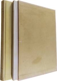
194922.1439Santander: Taller de Artes Gráficas de los Hermanos Bedia 1949 - 1952. 1ª ed. Once volúmenes encuadernados en plena piel verde. 17.5x25. Taller de Artes Gráficas de los Hermanos Bedia unknown
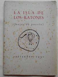
195117.930Santander: Tall de Artes Gráficas de los Hermanos Bedia 1951. 17.5x25. Camisas originales. Tall de Artes Gráficas de los Hermanos Bedia unknown
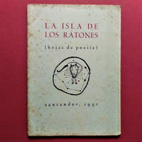
195122.1437Santander: Tall de Artes Gráficas de los Hermanos Bedia 1951. 17.5x25. Camisas originales. Tall de Artes Gráficas de los Hermanos Bedia unknown
20192-0464120543Blurb 2019. Hardcover. New. 476 pages. Spanish language. 8.31x5.32x1.42 inches. Blurb hardcover
1401JC071<p>Nuova Raccolta Colombiana. XI. Con la colaborazzione. di Pietro Barozzi Daniella Galassi Stefanella Guardo Maria Pia Rota. Ministero per i Beni Culturali e Ambientali. Comitato Nazionale per le Celebrazioni del V Centenario della Scoperta dellAmerica. Istituto Poligrafico e Zecca dello Stato. Roma. 1988.</p>_x000d_<p>Obra em 2 volumes. De 30x21 cm. Com 282 pags volume de ilustrações.</p>_x000d_<p>O 1º volume com encadernação do editor em pergaminho rígido com ferros a ouro na lombada e nas pastas e o segundo volume brochado acondicionados em caixa. </p>_x000d_<p>Obra impressa em papel de linho filigranado produzido especialmente para esta edição e apresentando marca-de-água com a efigie de Colombo em todos os fólios. Inclui bibliografia e índice.</p>_x000d_<p>Exemplar nº 47 de uma tiragem de 100 exemplares.</p>_x000d_<p>Ilustrado no segundo volume de Illustrazioni com mapas desdobráveis com a reconstituição estatística e gráfica de Ligúria e de Génova no tempo do navegador. Obra completa pertencente à colecção editada pelo Estado Italiano com o título de <em>Nuova Racolta Colombiana</em>.</p> I-28-D-3 unknown
2003Q-185974916XNew Holland Pub 2003-01-01. Hardcover. New. In shrink wrap. Looks like an interesting title! New Holland Pub hardcover
20121-3848468042Editorial Académica Española 2012. Paperback. New. 332 pages. Spanish language. 8.66x5.91x0.75 inches. Editorial Académica Española paperback
51-6449Paris: chez l'auteur dans l'Isle du Palais sur le quay de l'orloge a la Sphére Royale avec privilége du Roy 1705-1717. Engraved map. One fold. Worm hole in lower margin 27.3 x 38 cm. Contemporary laid paper uniformly time aged.Published in "L'atlas curieux ou Le monde reÌpreseÌnteÌ dans des cartes geÌneÌrales et particulieres du ciel et de la terre : diviseÌ tant en ses quatre principales parties que par eÌtats et provinces et orneÌ par des plans et descriptions des villes capitales et principales et des plus superbes edifices qui les embelissent comme sont les eglises les palais les maisons de plaisance les iardins les fontaines &c. ". OCLC Number / Unique Identifier:79022119.LThe Atlas Curieux is geographic encyclopedia of images and maps of France with detailed views of the grand waterworks at Marly views of the great palaces and chateaux views and plans of the Paris Observatory and samples of military architecture. Issued in six annual parts from 1700-1705 the maps are based on the new observations of the Académie des Sciences and drawn up with the assistance of Philipe de La Hire.ibrary of Congress:The French cartographer and engraver Nicolas de Fer was a master at creating maps that were works of art. The maps that he published were printed during the Baroque period when the decorative arts were characterized by ornate detail. De Fer’s detailed maps and atlases were valued more for their decorative content than their geographical accuracy.Nicolas de Fer was born in 1646. His father Antoine de Fer owned a mapmaking firm. At the age of twelve Nicolas was apprenticed to a Parisian engraver named Louis Spirinx. The family business was starting to decline when his father died in 1673. Nicolas de Fer’s mother Genevieve took over the business after the death of her husband. In 1687 the business was passed on to Nicolas and the profits increased after he took over the firm. Nicolas de Fer was a prolific cartographer who produced atlases and hundreds of single maps. He eventually became the official geographer to King Louis XIV of France and King Philip V of Spain.One of de Fer’s major works is an atlas titled L’atlas curieux The curious atlas. Paris: chez l'auteur dans l'Isle du Palais sur le quay de l'orloge a la Sphére Royale avec privilége du Roy, 1705-1717 unknown
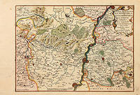
170578854Paris: 1705. Map of the Bishopric of Liege and the surrounding areas of Maastricht. Published in "Atlas Curieux ou le Monde". Copper engraving. Hand coloured. Size: 273 x 402 mm Very good condition. unknown
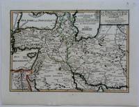
1703M5176Paris 1703. Excellent. Size : 230x335 mm 9x13.125 Inches Coloring: Original Outline Coloring Category: Maps Asia Near East Turkey; Maps Asia Middle East Iran Iraq; Maps Asia Middle East Caucasus.; unknown
0656840609.Ghardcover. Good. Access codes and supplements are not guaranteed with used items. May be an ex-library book. hardcover
0270800131.Ghardcover. Good. Access codes and supplements are not guaranteed with used items. May be an ex-library book. hardcover
1332396267.Gpaperback. Good. Access codes and supplements are not guaranteed with used items. May be an ex-library book. paperback
2226093214.Gpaperback. Good. Access codes and supplements are not guaranteed with used items. May be an ex-library book. paperback
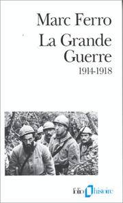
2007I-318-563Denoël 2007. Paperback. Good. Former library book. Ammareal gives back up to 15% of this item's net price to charity organizations. Denoël paperback