88 résultats
1898247238London: Rowland Ward 1898. First edition. Illustrated with photographs by the author and two folding maps in back pocket. 506 pp. 1 vols. 8vo. Mulberry cloth titled in silver. Lower inner hinge cracked spine ends rubbed. Very good. First edition. Illustrated with photographs by the author and two folding maps in back pocket. 506 pp. 1 vols. 8vo. Presentation Copy. A lively account of the author's adventures during an eight-month shooting trip in Baltistan Ladakh and Kashmir.<br/><br/>Very scarce.<br/><br/>A presentation copy inscribed on the half title: "Robert Frazer from his old schoolfellow the writer February 1898". Czech Asia 58 Rowland Ward unknown books
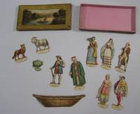
182518320French: n.p. 1825. Very good. 11 engraved cut-out figures or objects including ferryman three couples wolf goat cabbage and boat to be slotted into boat original box with engraved pictorial label colored by hand A rare children's game possibly printed by the Parisian publisher Nepveau. Contained in the box measuring 14cm x 7cm x 1cm is a complete set of figures for the two river crossing puzzles known as the 'Jealous Husbands Problem' and 'Goat Wolf and Cabbage'. The earliest account of these puzzles is in the 9th century manuscript "Propositionnes ad Acuendos Juvenes" Problems to Sharpen the Young attributed to Alcuin. In both puzzles there are only two places in the boat. In the Jealous Husbands Problem no woman can be with another man unless also accompanied by her husband. In Goat Wolf and Cabbage the wolf will eat the goat and the goat will eat the cabbage unless they are guarded by the boatman. Originally accompanied by counters and an instruction sheet now lost. The box is lightly worn else in very good condition; the figures are in fine condition except the boat which has been repaired and the cabbage which lacks the lower part of its insertion tab and one female figure lacks a hand. Rare. n.p. unknown books
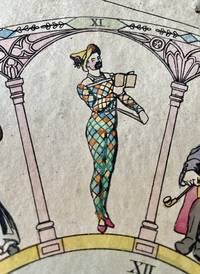
18405201<p>GAME. Arlequin und Columbine oder Arlequins Hochzeit. Nach der bekannten Pantomime gleichen Namens stellen bei diesem Spiele sämtliche Mitspieler Freier um Pantolons Tochter Columbine vor. n.p. n.p. ca 1830. </p><p> VAT in EU & UK</p><p>Lithograph broadside mounted on board 365 x 325 mm hand-coloured; board showing some staining and edges a little frayed; numbered 222 at bottom.</p><p>A well preserved board game played with two dice relating to the marriage of Harlequin and Columbine. Based on the well-known pantomime of the same name in this game all the players introduce suitors for Pantolon's daughter Columbine etc. The central circular field depicts the wedding couple surrounded by a number of acrobats. The surrounding twelve numbered arches show twelve stock male courtship figures all vying for Columbine's attention. The four corners show Commedia dell'arte figures.</p><p>Clockwise from the top the arches are numbered 2 7 5 4 10 2 8 3 6 9 2 11 while the central circle is numbered 12. The numbers thus represent all chances upon double dice with double 1 appearing three times. The rules give pay or take instructions for the various throws. The rules of the game are printed below. One participant is the 'banker' who organises the game and takes the pawns from all participants and arranges for the money to be distributed. The players throw dice andmove along according to their results.</p><p>This board game is number 222 from the fund of an unknown German publisher printed about 1840.</p><p>See Plock Phillippa and Adrian Seville "The Rothschild Collection of printed board games at Waddesdon Manor" in XIIIth Board Game Studies Colloquium Paris 14-17 April 2010; Buijnsters P.J. Papertoys. Speelprenten en papieren speelgoed in Nederland 1640-1920. Waanders Uitgevers-Zwolle 2005.</p> n.p.
189578554August 1895 - 1978. original padded leather. The album's spine is perished with light wear at edges; contents sound and fine. 8vo. Illustrated throughout. The first page is an amusing original hand-colored cartoon of a Victorian couple cowering in front of a pig initialled "A.T." Following are 175 pig drawings all signed and most dated and many with a location. Dozens are neatly filled in in black and one is flesh-colored. 117 drawings were made between 1895-1900; 26 from 1900-1910 . hardcover
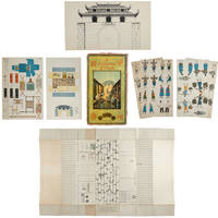
1900159678London.: Church of England Zenana Missionary Society. No date. circa1900. Nine printed sheets each printed with people or items and showing the cut lines. Original chromolithograph card box archivally repaired along seams. Some occasional light foxing on sheets card covers browned and worn in places a few other minor signs of wear but generally very good. 43 x 24cm. Rare. We have found no other copies of this game. The first two sheets show Chinese people in clothes appropriate to their age occupation etc. Those illustrated include The Opium Smoker School-master The General Shopkeeper Native Biblewoman etc. Other sheets show furniture and fittings a coloured illustration of the street a black and white image of the city gate and a much larger sheet 50 x 87.5cm which is an illustration of the street and onto which the other cut-outs when coloured and cut out are placed. . Church of England Zenana Missionary Society. hardcover
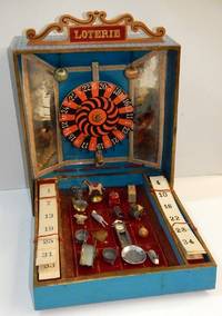
19002210013<p><i>Wooden box 32 x 26 x 8 cm with light blue patterned paper covering; the lid with a label lettered 'Loterie' and a hinged pierced wooden sign with the words 'Loterie' lettered in gilt paper on red; the lined paper interior with a central mounted wheel between mirrored sides and two hanging silk balls; the fall front where the prizes are held with two spaces left and right containing six lottery cards one from another set together with 16 toy prizes as listed below.</i></p><p>Lottery or carnival wheels games became popular at the end of the nineteenth century. Their construction was more complicated than heretofore with the addition of a rotating wheel with pins with a 'clack' mechanism sounding as the wheel is spun. The numbers on the wheel are randomly arranged from 0 through to 25 in white on alternating in black and red ground - clearly based on the 'single zero' form of roulette wheel that became the norm in Europe from the middle of the nineteenth century. The design has a second purpose as the box is hinged so that open it is given the form of a fairground entertainment with an assortment of prizes laid out in a display on squares below the wheel that each have a number too. </p><p>The idea of the game is twofold firstly as the wheel is spun and numbers called out the player who first completes a card of numbers is the winner. In the second game when the numbers 1 to 16 are called out and a player has the number on one of the cards they can then claim one of the small toy prizes. The sixteen twenty assorted of toy prizes include: a handcart wall clock bracelet scales pram wooden top bracelet fairground horse two rabbits a chicken a dish a parcel a metal top metal puzzle pair antimony jardinieres and a heart broach.</p><p>There is no makers name and the design although of a solid construction is nevertheless probably a bespoke production possibly made in order to be sold through fairgrounds and market stalls rather than the more salubrious emporia for children. The interior is lined in turquoise paper with bevelled mirrored silvered card sides and although simple the idea was glittery enough to catch any passing child's attention.</p>
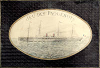
18972210164<p><i>Comprising two coloured map board 66 x 99 cm folding down to 32.5 x 49.5 cm one cloth hinge broken; 14 route cards; a barometer dial 19 x 19 cm with gilt metal spinning arrow some abrading from use; eight painted white metal playing pieces in the form of ships contained in the original small box one piece not original; 16pp booklet of instructions bound in original light green printed wrappers; all contained in the original box 35 x 52 x 5 cm; the hinged lid with a large coloured lithograph title label showing the 'Normandie' leaving port at full steam some minor abrasions but overall in good condition.</i><br /></p><p><i>Jue des Paquebots</i> was something new to games when it was published in 1897 as each player moves their boats on large maps exactly replicating the routes taken by two major French shipping lines. </p><p>The game includes two large folding boards designated 'Carte A' which illustrates the Atlantic shipping lines the other 'Carte B' with the shipping lines leaving Marseilles in the direction of the Black Sea the Indian Ocean and the Pacific. Rather pointedly the instructions state that the two maps include only the French shipping lines of the Messageries Maritimes and the Cie Générale Transatlantique the United Kingdom then the leading maritime nation is neither shown on the maps nor mentioned. </p><p>The players first decide which map they are going use and then select or bid one of the Itinerary cards 8 for map A and 6 for map B. The aim of each player is to complete the journey indicated by their itinerary and then make the return voyage; the first player to complete this double crossing wins. However the number of stopovers is not equal for each different itinerary in play. In order to equalise the chances of winning the players with the fewer ports of call have to repeat their journey a second or even a third time if necessary until the number of ports visited or passed by them in these different routes equates to the number of ports of the busiest route.</p><p>The routes all follow those which the two major French shipping companies plied. These include final destinations at Yokohama Australia New Zealand Zanzibar Odessa Buenos Ayres New York and the Antilles. </p><p>Each player places a ship playing piece at port at the beginning of their route. The first player now spins the Barometer Dial which has outer and inner instructions that allows them to advance out of port when their turn come around again the arrow is again spun and the player can read the inner line of instructions and so advance 1 2 or 3 ports along their route. However there are also stops on the Barometer Dial that include Damage - where you go back to the previous port and pay a token to the bank; Heavy Fog - where you are left stranded until the next round; Collision - this allows another turn of the dial but it the result is 50/50 chance of being sunk and thrown out of the game - you can pay for another ships so all is not lost; Call for Distress - also misses a turn; Shipwreck - something like collision although you can start out again with a new ship and no fine; Rescue - also causes the player to miss a turn; lastly and somewhat topical there is Quarantine - here the player misses a turn and also has a second spin of the arrow to determine if you can go into port or not.</p><p>The lid of the box illustrates the Cie Général Transatlantique liner La Normandie that plied the North Atlantic to New York in the summer and the south Atlantic in the winter - the ship sports a US flag on the foremast and the makers initials on the aft mast. Built in 1886 it was the largest and fastest liner of the company and was originally named 'Ville de New York.' It was also lit by electricity and could carry 1000 passengers and became the model for several sister ships built to the same plan.</p><p>The maker Charles Watilliaux succeeded the games manufacturer Coqueret in 1874 and for the next 35 years became a major publisher and manufacturer of board games and toys until their acquisition by Revenaz & Tabernat. His registered initials were 'W.X.' which is slightly modified for the flag on the box lid as C.W.X.</p> Watilliaux, éditeur.
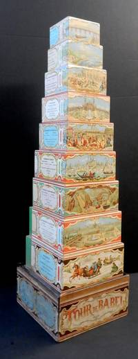
18823220299<i>A nest of nine wooden blocks ranging in size from 78 x78 x 46 mm to 182 x 182 x 60 mm each with a chromolithograph wrap-around illustration depicting European countries with statistical information; contained in the original box with a wrap around title label including four cartouche scenes printed in blue; with a sliding lid replaced.</i><br /><br />Each of the blocks is illustrated with a typical scene from European countries Russia the largest block showing a number of troikas in a winter landscape Germany & Austria with a view of Vienna Sweden and Denmark with mining for iron Turkey & Greece with a view of Istanbul etc. Also included are cartouches with basic information on the population and chief products of each country. <br /><br />The now ubiquitous graduated nested set of blocks for children was quite a late development in toy design with the earliest known patent being applied for in the US in 1881. Watilliaux's Tour of Babel was first marketed as interlocking jigsaw like pieces that could be joined together as hexagons and then stacked to form a tower that was issued at the time of the 1878 Paris Exposition here depicted as the illustration representing France. However when first American nested blocks began to appear Watilliaux evidently adapted the printed design and applied it to his own set of graduated blocks. Unfortunately this reworking did not quite fit the increased surface area of the blocks and a blank section has perforce had to be filled by a section of green glazed paper. It also necessitated the dropping the country of Switzerland and in that case the original pattern was too large to be adapted without their being some lose to the design.<br /><br />No doubt the original design had some educational value although this is somewhat lessened as there is no dexterity needed to correctly interlock the jigsaw pieces and instead only to stack and knock down the Tour de Babel.<br /><br />In 1874 Charles Watelliaux took over the publisher and manufacturer of many board games and toys Bernard Coudert and became a major producer until its sale in 1908 to Revenaz & Tabernat. Watilliaux, Editeur, Lith. J. Marie, Faub St Denis, 61.
18760041461876 Paris, J. Rothschild, 1876. Petit in-folio (288 X 362) demi-chagrin vert lierre, dos cinq nerfs, fleuron doré dans les compartiments, auteur et titre dorés, nom de l'éditeur en queue, tranches dorées (reliure de l'époque); (1) f. blanc, (2) ff. de faux-titre et titre imprimé en rouge et noir, frontispice, 140 pages, 45 planches couleurs hors-texte sous serpente, (1) f. blanc. Quelques rares rousseurs, principalement aux serpentes, trois taches sur le cuir du plat supérieur, sans gravité.
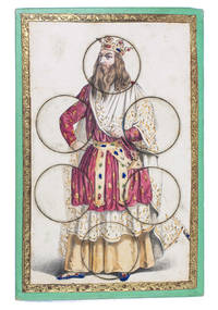
184017799Paris 1840. 19.5 x 13 cm. R. Lacouchin With 3 finely lithographed plates mounted on 3 thick green paperboard cards. The lithographs are framed with a gold-coloured ornamental border. The images on the cards are all beautifully hand coloured and the 3 cards depict respectively a crowned king in ornate robes a beautiful young lady in a green dress and a young man or possibly a court jester in an extravagant yellow and green outfit. Each card has 6 large circular movable pieces to be removed or inserted as the game demands in various circumstances. 3 puzzles. Three beautiful and complete puzzle cards with round movable pieces for example for a game of metamorphosis or lotto. While no rules are present or other specific indications given the cards with their beautiful coloured illustrations are quite intriguing by themselves.The illustration of the young man in the yellow and green outfit is signed "R. Lacouchin". Slightly foxed otherwise in very good condition. unknown
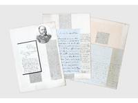
1837156409Kabul and elsewhere: 1837-41 & 1859. Correspondence chess A carefully assembled collection of material connected to players in the "great game" including Colonel Stoddart and Captain Arthur Conolly both famously beheaded at Bukhara Major Henry Rawlinson the political agent at Kandahar and Captain Sir Alexander "Bukhara" Burns. The material mounted on album leaves with accompanying newspaper clippings and other ephemera is tied together by Connolly and Stoddart's dramatic death. Sent on a mission to secure an agreement of friendship between Britain and the Emir of Bukhara in 1838 Stoddart was arrested by the emir on charges of spying and imprisoned. Conolly the intelligence agent credited with coining the term "great game" in an 1840 letter to Rawlinson arrived in Bukhara in late 1841 to negotiate his compatriot's release. Both men were killed in June 1842 and became household names back home. In the first two letters Burns writing about a year before he was killed by a mob in Kabul shares his views with Rawlinson on the latest moves in the "great game". He writes of Stoddart's short-lived release from prison and of the importance of Conolly's current intelligence-gathering in Central Asia. Shah Shuja "is surrounded by a parcel of harpies" and Burns advises caution about the use of British troops to prop up the Shah's rule: "Nothing contributes so much to lower the King's power as the employment of our troops against Afghans & I would avoid it if possible." As for Lord Auckland the governor-general "does not have great faith in the sincerity of Russia in abandoning her Khiva designs but it gives us time." The third letter from Conolly to Rawlinson discusses local news and offers a lighter-hearted window onto the life of a political agent far from home. He has swapped the diplomatic chessboard for the card table: "We miss you very much - especially at whist" the previous night's rubber being "stale and flat but not unprofitable for I won 9 rupees." This letter is mounted with a page of Stoddart's notes on taking navigational bearings which Stoddart gave to Rawlinson before departing for Central Asia in 1837. The final piece touches on the wider appeal of the Stoddart-Conolly story. Writing to the Cornish baronet Sir Hugh Molesworth almost two decades later Dr Joseph Wolff mentions his second expedition to Bokhara mounted to ascertain the fate of the two men and how the profits from the two editions of his best-selling Narrative of a mission to Bokhara 1845 were sufficient to finance a parsonage and schoolhouse in his living. a Sir Alexander Burns to Major Henry Rawlinson 21 December 1840 Kabul. ALS bifolium written across all sides. b Sir Alexander Burns to Major Henry Rawlinson 20 January 1841 Kabul. ALS bifolium written across all sides. c Captain Arthur Conolly to Major Henry Rawlinson 1840 Kabul. ALS bifolium and single sheet written across 5 sides addressed on final side remains of wax seal. d Colonel Stoddart's autograph notes on taking navigational bearings single sheet written one side. Endorsed on verso by Rawlinson "Given to me by Col. Stoddart on his departure for Bokhara in 1837. H. Rawlinson"; later note to the same effect but in a different hand below. e Revd Dr Joseph Wolff to Revd Sir Hugh H. Molesworth 31 August 1859 Taunton Somerset. ALS bifolium written across 3 sides. 4 autograph letters and single sheet of notes totalling 17 sides of manuscript tipped to or mounted on stubs to card album leaves 370 x 265 mm with laid-down material 11 newspaper clippings 2 printed illustrations sheet of manuscript later brief captions in manuscript. Letters and sheet of notes generally well preserved staining and creasing as expected stubs occasionally just touching text but no loss to sense: a very good collection. unknown
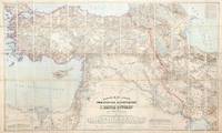
1899155664Dehra Dún India & Berlin: Photozincographed at the Office of the Trigonometrical Branch Survey of India & Dietrich Reimer 1899-1904. Remarkable assemblage of three important and superbly detailed maps A rare opportunity to acquire three exceptionally impressive and uncommon maps together forming the finest contemporary cartographic overview of the Great Game's central theatre. Spanning from the Mediterranean to Afghanistan and from the Caspian to Sir Baniyas Island they present a striking synoptic view of the region at a moment of intense strategic interest. All three share the same provenance each bearing the distinguished bookplate of the officers' mess library of the 85th Foot later part of The King's Light Infantry. Likely acquired as a group by an officer attuned to imperial affairs in the run-up to or immediate aftermath of the 1907 Anglo-Russian Convention they reflect the period's effort as Hopkirk notes to resolve regional rivalries and curb Germany's eastward ambitions. The Persia map is a landmark Survey of India production and the most comprehensive rendering of the region then available incorporating the latest British and Russian surveys and reconnoitres. Only 300 copies of this August 1904 issue were printed and institutional locations are limited to the British Library Deutsche Nationalbibliothek and Sächsische Landesbibliothek. The impressive wall map of Afghanistan June 1901 produced under Strahan and Gore and executed at the Frontier Drawing Office under Colonel R. A. Wahab is equally rare with copies recorded only at the British Library Wisconsin and the Bayerische Staatsbibliothek. Its authority rests on extensive British and Russian sources including work by Robertson Trotter Sykes Ney Elias and the Afghan Boundary Commission. These maps exemplify the Survey of India's exacting standards during the era of photozincographic production when officers were required to vet every detail under magnification. Kiepert's map of the Ottoman Empire complements the two Survey of India sheets representing the best contemporary mapping of a region Britain could not itself survey. Kiepert one of the foremost scholarly cartographers of the 19th century travelled widely in Ottoman territories producing clear and remarkably accurate maps that remain valuable records of the period. This map is comparatively well represented institutionally with around 17 holdings recorded in Europe the US and the UK. Persia: scale 1:1013760 six-sheet coloured map divided into four linen-backed quadrants each measuring approx. 976 x 963 mm when assembled measuring 1952 x 1926 mm North West North East South West South East each backed with Nonpareil pattern marbled paper each section dissected into 20; Afghanistan: scale 1:1013760 coloured map dissected into 45 sections linen backed measuring approx. 1035 x 1640 mm; Turkey: scale 1:1500000 coloured map dissected into 65 sections linen backed measuring approx. 1016 x 1700 mm; together with the "Apercu general" measuring 412 x 570 mm showing the administrative division of the same area intended to accompany the map; dissected into 10 sections linen backed. Each map housed in the original dull purple morocco-grain cloth case Stanford's printed label to front. Cases a little worn with some loss of fabric light toning to maps otherwise in excellent condition. Cases a little worn with some loss of fabric occasional light toning to maps otherwise in excellent condition. Kourosh Ahmadi Islands and International Politics in the Persian Gulf: Abu Musa and the Tunbs in Strategic Perspective 2008; Kyle J. Gardner The Frontier Complex: Geopolitics and the Making of the Indo-China Border 1846-1962 2021; Peter Hopkirk The Great Game: On Secret Service in High Asia 1992. hardcover
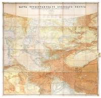
1881149774St Petersburg: Cartographic Institute of the Military-Topographic Department of the General Staff 1881. The cartographic climax of the "great game" Second edition significantly improved from the first edition 1877 to incorporate the latest military intelligence from field surveys. This magisterial work of "great game" cartography was presented at Russia's Tashkent military headquarters to the daring French explorer Stanislas Benoist-Méchin during his epic 1881-3 overland journey from Beijing to Europe. We have traced no other copies. A presentation inscription on the verso of the map reads in French "To Mr Baron Benoist-Méchin from Generals Kouropatkine and Levaschew October 1882 Tashkent." Benoist-Méchin 1854-1923 began travelling the world as a young man and then served as the French cultural attaché in Tokyo 1880-1. In 1881 he decided to return to Europe via the daring route through Central Asia. Leaving Beijing on 15 September with his regular travelling companion Comte Humbert Adrien de Mailly-Chalon 1853-1921 he journeyed through Manchuria and across Russian Siberia. In 1882 having reached Kashgar they received permission to cross Russian Turkestan spending six weeks in Tashkent as the honoured guests of General Mikhail Tchernayev the architect of Russian's expansion across Central Asia General Aleksey Nikolayevich Kuropatkin 1848-1925 and the aforementioned General Levaschov likely the artillery officer Vladimir Levaschov 1834-1898. After reaching Samarkand they travelled in extreme cold through Bukhara and via Khiva to Tehran reaching Moscow in October 1883 where they were accorded a hero's welcome. Their descriptions of this feat of exploration were published in 1885 in the Bulletin de la Société de géographie. This map was made for the use of the Russian military high command in St Petersburg and in the Turkestan Military District which had been established in the 1860s amid the occupation of Tashkent and Bokhara and dates from a period following the Second Anglo-Afghan War and the Battle of Geok Tepe when tensions were at their height. It encompasses almost the entire playing surface of the "great game" extending east-west from Xinjiang and Tibet to the Caspian Sea and Afghanistan and north-south from Siberia to northern India. Unparalleled in terms of accuracy and detail it names every city town and village and the legend has entries for such features as fortifications railways mail and caravan roads and mines. Spot heights are given in feet and deserts are marked with a light red pattern. It is much improved on the first edition which had only 48 panels and did not extend as far south. Chromolithograph map 195 x 200 cm dissected onto 64 sections and mounted on linen as issued laid-down printed slip stating "corrected up to 1881" small folding tab at right edge. Folding away to 28.5 x 28 cm. Housed in green quarter morocco solander box with chemise by the Chelsea Bindery. Map surface generally clean and brighta few stains toning and soiling at edges small repair at top-left edge verso foxed and with couple of areas of linen reinforcement: very good. unknown